

Recomendados
Mais conteúdo relacionado
Mais procurados
Mais procurados (20)
Semelhante a Physical GEOG: Chapter 6 - Elements of Weather
Semelhante a Physical GEOG: Chapter 6 - Elements of Weather (20)
Mais de Sofian Muhd
Mais de Sofian Muhd (20)
Último
Último (20)
Physical GEOG: Chapter 6 - Elements of Weather
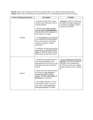
- 1. Weather refers to the conditions of the atm at a specific place over a relatively short period of time. Climate refers to the atm conditions of a specific place over a considerable period of time (30-35 years) Factors affecting temperature Description Example - In general, temperatures experi- - Singapore, which is located near enced at a place decreases with in- the equator, has high temperature creasing latitudes. as compared to Canada, which is located near the Poles. - The sun’s rays strike countries near the equator perpendicularly, but strike those at the temperate or polar regions at an angle. Latitude - As solar radiation is concentrated over a small area near the equator, heat is more intense, hence these countries experience a higher temperature. - In addition, the sun’s rays travel a greater distance through the atmo- sphere to reach the region near the Poles, hence are less intense there. - Temperature generally decreases - Cameron Highlands and Genting with increasing altitude in the Highlands in Peninsular Malaysia troposphere, the lowest layer of the experience lower temperatures atmosphere just above the Earth’s (15-22°C) since they are at higher surface. altitudes than most cities in Malay- sia. - Places nearer the sea level tend to be warmer as solar radiation is Altitude absorbed the Earth’s surface directly. Air above the surface is heated up via conduction. - Air at higher altitudes is thinner and contains smaller concentrat- ions of gases, hence heat is less effectively absorbed or trapped.
- 2. - Coastal areas in temperate - San Diego in USA experiences regions tend to experience more moderate winters and moderate climates due to the summers and has a smaller difference in the rates of heating temperature range than Winnipeg and cooling of land and sea. in Canada as the former is near the coast. - During summer, air over the land heats up faster than the air over the sea as the sea has a higher heat capacity. The cooler air over the sea hence lowers the temperature of areas along the coast. Distance from sea - Conversely, during winter, air over the sea remains warm compared to air over the land. This raises the temperature of coastal areas. - Due to maritime effect, coastal areas tend to experience warmer winters and cooler summers than inland areas which experiences continental effect that tends to have cooler winters and warmer summers. - In arid regions with low RH and relatively cloud-free skies, such as the Sahara Desert, large amounts of solar radiation can reach the Earth’s surface in the day, causing the temperature to rise quickly. - At night, lack of cloud cover allows heat to escape easily into outer space, leading to a sharp decrease in temperature. Cloud cover - Conversely, places with thick cloud cover reflect part of the -------- incoming solar radiation in the day back into outer space, hence decreasing the amount of solar radiation absorbed by the Earth’s surface. - Also, at night, cloud cover prevents heat from escaping into outer space, keeping the temperature of the ground relatively high.
- 3. - Warm ocean currents originate - Vancouver, Canada has a from the Equator while cold ocean generally cooler temperature than currents originate from the Poles. Brest, France as Vancouver Ocean currents - Cold ocean currents exert a experiences the cool California cooling effect on coastal cities Current while Brest experiences while warm ocean currents exert a the warm North Atlantic Drift. warming effect in coastal cities. - A city with buildings with - Temperatures experienced in concrete walls and little trees are parks and nature reserves in warmer than a village made with Singapore are generally lower natural materials and a lot of trees. than those experienced in the Microclimatic factors - This is because concrete traps industrial and built-up residential hear and makes the place warmer or city areas. while trees release water vapour thru evapotranspiration that cools the temperature down. Formation of convectional rain 1. The Sun heats up the Earth’s surface and this causes the air above it to be heated up as well, causing it to rise quickly. 2. At high altitudes, temperature drops and condensation occurs after RH exceeds 100% / beyond saturation point. Clouds begin to form when water droplets merge together. 3. When clouds get too heavy, heavy rain falls and is usually accompanied by thunder and lightning. 4. At the same time, warm air continues rising and condensation continues to occur. However, when clouds lose their moisture, rain will ease. Formation of relief/orographic rain 1. When wind blows over a sea or large lake, it picks up large amounts of water vapour from above the surface of the lake. This increases the RH of the air. 2. Air is then forced to rise up the mountain in the direction of the prevailing winds. 3. At high altitudes, temperature drops and condensation occurs after RH exceeds 100% / beyond saturation point. Clouds begin to form when water droplets merge together. 4. When clouds get too heavy, relief rain falls mostly on the windward side (the sea side). By the time the air reaches the leeward side (the not-facing-the-sea side), the air would have lost most or all of it moisture. 5. The air then descends and is warmed by heat near the Earth’s surface and become a dry wind. Rain shadow effect occurs.
- 4. Formation of Southwest Monsoon (June-Sep) Formation of Northeast Monsoon (Oct-Jan) 1. During June-September, the NH experiences 1. During October-January, the NH experiences summer while the SH experiences winter. winter while the SH experiences summer. 2. Hence, the Asian continent/ Indian sub- 2. Hence, the Asian continent/ Indian sub- continent is warmed and hot air rises forming a continent is cooled and cold air sinks forming a region of low pressure. In the Australia region of high pressure. In the Australia continent, the continent is cooled and cold air continent, the continent is warmed and hot air sinks forming a region of high pressure. rises forming a region of low pressure. 3. Generally, winds blow from S to N (High Low) 3. Generally, winds blow from N to S (High Low) 4. In SH, winds are deflected to the left and in the NH, winds are deflected to the right due to 4. In NH, winds are deflected to the right and in the Coriolis effect. the SH, winds are deflected to the left due to the Coriolis effect. TO EXPLAIN RAIN TO INDIA: 5. As the Southwest Monsoon winds pass the TO EXPLAIN RAIN TO MALAYSIA: Indian Ocean, it picks up large amounts of 5. As the Northeast Monsoon winds pass the moisture which falls as rain on India esp to cities South China Sea, it picks up large amounts of on the western coast of India. moisture which falls as rain on India esp to cities on the eastern coast of Malaysia.