Results of 3 regional cigs
•
0 gostou•72 visualizações

This document summarizes a national project to develop phosphorus indices and assess phosphorus loss for four regions across the United States. It involved establishing benchmark watersheds, identifying agricultural practices of concern, and comparing models like APEX, APLE and Drainmod to measured water quality data. The project found that calibrating models was challenging due to limited data and issues with model codes. It also found that modeled phosphorus loss estimates did not always match measured data and that developing a single national phosphorus index framework remains difficult. Models need updates to better represent regional hydrology and subsurface phosphorus loss.

Recomendados
Recomendados
Mais conteúdo relacionado
Destaque
Destaque (10)
Semelhante a Results of 3 regional cigs
Semelhante a Results of 3 regional cigs (20)
Mais de Soil and Water Conservation Society
Mais de Soil and Water Conservation Society (20)
Último
Último (20)
Results of 3 regional cigs
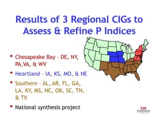
- 1. • Chesapeake Bay – DE, NY, PA,VA, & WV • Heartland – IA, KS, MO, & NE • Southern – AL, AR, FL, GA, LA, KY, MS, NC, OK, SC, TN, & TX • National synthesis project
- 2. Peter Kleinman & Doug Beegle• Establish 11 benchmark watersheds Water quality information Land treatment information • Identify practices of concern in physiographic regions (4) using expert panels composed of Farmers & farm advisors State and local agencies & environmental groups • Compare P Indices to water quality data & water quality modeling data using APEX, APLE & Drainmod
- 3. • All fate & transport models need to be updated to better represent Site-specific hydrology (dependent on region)
- 4. This is what we must represe 177 144 44 1 < Soil P – mg kg-1 Runoff – liters P loss – kg P ha-1 y 92 Buda et al. JEQ, 20 Lowest field is now a CREP buffer that continues to yield largest P load 4620 DPDPDP 8 DPDPDP78
- 5. Application rate Collick et al. JEQ, 2016 6000 gal ac-1 9000 gal ac-1 NewOld NewOld 6 3 0 Runoff total P, kg ha-1 Field 1 Field 2 P routines must be updated in ALL MODELS Application timing New Old 1/15 1/31 2/14 0.1 0 0.2 6000 gal ac-1 Runoff total P, kg ha-1
- 6. 0.00 0.25 0.50 0.75 1.00 1/1/2010 2/20/2010 4/11/2010 0.0 1.0 2.0 3.0 4.0 1/1/2010 2/20/2010 4/11/2010 0 10 20 30 40 50 Measured Old New No manure applied Poultry litter applied, January (2 tons ac-1) Runoff P, mg L-1 Rainfall, mm
- 7. John Lory, Nathan Nelson & Claire Baffaut • Assess rigor required in calibrating APEX Use data from existing runoff studies Compare “out-of-the-box” versus fully calibrated model • Use calibrated model to assess & modify P Indices • Develop & assess regional P Index for state consideration • Work with stakeholders throughout project
- 8. • Team vastly under-estimated time & challenges with Accessing & validating available water quality data Fixing problems identified in model code Delineating boundaries where use of APEX can be trusted based on available water quality data These challenges not unique to Heartland effort • Success promoting “team” approach to problem solving Transdisciplinary team with different approaches learned to work together was rewarding
- 9. Deanna Osmond & David Radcliffe • Collate water quality & land treatment data for plots & watersheds 7 AR, 1 GA, 4 NC, 4 OK, and 4 TX • Compare P-Index ratings against water quality data Using both measured sediment & RUSLE2 soil loss
- 10. 0 20 40 60 80 • RUSLE 2 estimates of erosion were up to an order of magnitude greater than measured values • NRCS loss ratings Low < 2.2 kg ha-1 yr-1 Moderate 2.2 to 5.5 kg ha-1 yr-1 High > 5.5 kg ha-1 yr-1 • How did tools compare with NRCS P loss ratings? Percent correspondence with NRCS loss rating 34 61 52 48 60 64 P INDICES TBET APLEAPEX Added Multiply Comp
- 11. • TBET Modeling TBET very time consuming with uncertain outcomes TBET almost always over-estimates total P loss • APEX Model setup requires information not available to most producers APEX use was time consuming with uncertain outcomes Modeled results almost always under-estimates total P loss • APLE Modeling APLE less time consuming than TBET & APEX Modeled results almost always over-estimates total P loss • None appropriate as field-based tool, if uncalibrated
- 12. •Invaluable network among NRCS, Land Grants, & stakeholders developed •Estimating P transport (surface & leaching) still major limitation •There is considerable “uncertainty” with all models and Indices •Variation in model estimates can be ±100% •Soliciting expert knowledge & converting it to models very difficult
- 13. •Models can arrive at the right conclusions for the wrong reasons •To a certain extent model calibration & validation detracted from P Index assessment
- 14. • We are far from developing framework of single national P Index • If a field advisory tool, must be simple to use & interpret • If a model, then we have many nonpoint source models • But…. • All fate & transport models need to be updated to better represent Site-specific hydrology (dependent on region) Subsurface P loss is high priority 4R’s of nutrient stewardship