SlideShare uma empresa Scribd logo
1 de 2
U.S. GEOLOGICAL SURVEY
Fact Sheet 2004-3060

Mapping a Flood...Before It Happens
By J. L. Jones

What's missing from flood forecasts?

Maps—The only maps generally available today are maps used for
planning. They are maps of theoretical floods, not maps of flooding
forecast for an approaching storm. The U.S. Geological Survey (USGS)
and the National Weather Service (NWS) have developed a way to bring
flood forecasting and flood mapping together, producing flood maps for
tomorrow's flood today...and getting them on the Internet in time for
those in harm's way to react.


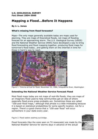
Figure 1. Time-to-arrival for flood, November 23, 1986, Snoqualmie River, Washington

Extending the National Weather Service Forecast Flood

Most flood maps today are not maps of real-life floods; they are maps of
an imaginary flood used to help communities get an idea of where
especially flood prone areas probably are. Sometimes these are called
"100-year flood maps," although that phrase is a little misleading because
it is based on statistical probabilities for some specific location, not for a
region. There's a good chance that a "100-year flood" will occur
somewhere in your state every year.


Figure 2. Flood waters washing out bridge.

Flood forecasts (like the ones seen on TV newscasts) are made by the
National Weather Service for storms days in advance of the actual
flooding. These forecasts estimate the highest level the river will get,
based mainly on how much rain is expected. Unfortunately, the forecasts
are made only for a few specific places; they don't predict flood levels for
anywhere except those specific places. So, unless you live near one of
these "forecast points," the predictions are good only as a rough measure
of how large the flood is predicted to be. They don't tell you whether your
house, or a school, or your local sewage treatment plant is in danger of
being flooded. Even if you do live near a forecast point, the forecast is still
only an elevation describing the highest expected river level. It doesn't
mean a lot to you unless you know your elevation compared to the
reference elevation, or "datum," of the forecast point. What you want if
you live in a floodplain, whether you live near a forecast point or not, is a
map that shows where flooding is expected.

When the NWS issues a forecast flood hydrograph (plot of flow vs. time)
for a particular location, the USGS uses the hydrograph to create a flood-
inundation map. The USGS has developed methods to make maps of
these forecast floods for long stretches of a river near forecast points.
These maps fill a critical information gap in flood forecasting: information
on when and where floodwater from an approaching storm will arrive. The
maps also show how deep the water is expected to be all across the
floodplain. In essence, these methods combine to make a somewhat
obscure "peak forecast elevation" into a map with flooded areas, times-of-
arrival, and flood depths.

A number of new technologies and methods make the creation of flood
forecast maps possible. First is the ability to get very accurate elevations
throughout the floodplain quickly and affordably. This is done with
"LIDAR" technology (see more below). Second is a computer program
(TRIMR2D) that can simulate flood flows all across the floodplain and
many, many miles downstream from the forecast point. Third is spatial
analysis software (GIS) that turns the model results into maps and
overlays them on other maps, like a map of a neighborhood, or even onto
an aerial photograph. Last is software (IMS) that makes the maps
available on the Internet in a flexible and user-friendly way. (You can see
a demonstration of the system on the Web at
http://wa.water.usgs.gov/projects/pugethazards/urbanhaz/MappingNWS.
htm.)

Mais conteúdo relacionado

Mais procurados

Sunu (1) kopyası kopyası (1)
Sunu (1) kopyası kopyası (1)Sunu (1) kopyası kopyası (1)
Sunu (1) kopyası kopyası (1)demirdemirel
 
Ch. 1.2--Geographer's Tools
Ch. 1.2--Geographer's ToolsCh. 1.2--Geographer's Tools
Ch. 1.2--Geographer's ToolsJohn Hext
 
1.2 - The Geographer’s Tools
1.2 - The Geographer’s Tools1.2 - The Geographer’s Tools
1.2 - The Geographer’s ToolsDan Ewert
 
Using GIS for effective flood management
Using GIS for effective flood managementUsing GIS for effective flood management
Using GIS for effective flood managementJames Thompson
 
GEOGRAPHIC SKILLS: CHOROPLETH MAPS
GEOGRAPHIC SKILLS: CHOROPLETH MAPSGEOGRAPHIC SKILLS: CHOROPLETH MAPS
GEOGRAPHIC SKILLS: CHOROPLETH MAPSGeorge Dumitrache
 
Geography Skills - Thematic Maps & Climate
Geography Skills - Thematic Maps & Climate Geography Skills - Thematic Maps & Climate
Geography Skills - Thematic Maps & Climate Tim Bonnar
 
The geographer’s tools
The geographer’s toolsThe geographer’s tools
The geographer’s toolsAaron Carn
 
Disaster management Past, Present, and Future
Disaster management Past, Present, and FutureDisaster management Past, Present, and Future
Disaster management Past, Present, and FutureParthPatel1613
 
UROP Symposium Poster
UROP Symposium PosterUROP Symposium Poster
UROP Symposium PosterNeil Schwartz
 
Geographic Information System(GIS) and Remote Sensing(RS) in Disaster Managem...
Geographic Information System(GIS) and Remote Sensing(RS) in Disaster Managem...Geographic Information System(GIS) and Remote Sensing(RS) in Disaster Managem...
Geographic Information System(GIS) and Remote Sensing(RS) in Disaster Managem...Our slides
 
ICI-RAFT (presented at AMS 2012)
ICI-RAFT (presented at AMS 2012)ICI-RAFT (presented at AMS 2012)
ICI-RAFT (presented at AMS 2012)giovanja
 
Globes and maps for class 6
Globes and maps for class 6Globes and maps for class 6
Globes and maps for class 6Akanksha
 
How Does GPS Work? And Why Do You Need To Understand It?
How Does GPS Work? And Why Do You Need To Understand It?How Does GPS Work? And Why Do You Need To Understand It?
How Does GPS Work? And Why Do You Need To Understand It?Bob Mayer
 

Mais procurados (20)

Sunu (1) kopyası kopyası (1)
Sunu (1) kopyası kopyası (1)Sunu (1) kopyası kopyası (1)
Sunu (1) kopyası kopyası (1)
 
Ch. 1.2--Geographer's Tools
Ch. 1.2--Geographer's ToolsCh. 1.2--Geographer's Tools
Ch. 1.2--Geographer's Tools
 
GEOGRAPHIC SKILLS: DOT MAPS
GEOGRAPHIC SKILLS: DOT MAPSGEOGRAPHIC SKILLS: DOT MAPS
GEOGRAPHIC SKILLS: DOT MAPS
 
1.2 - The Geographer’s Tools
1.2 - The Geographer’s Tools1.2 - The Geographer’s Tools
1.2 - The Geographer’s Tools
 
Using GIS for effective flood management
Using GIS for effective flood managementUsing GIS for effective flood management
Using GIS for effective flood management
 
Themating maping
Themating mapingThemating maping
Themating maping
 
World At Night
World At NightWorld At Night
World At Night
 
Risk_CA
Risk_CARisk_CA
Risk_CA
 
GEOGRAPHIC SKILLS: CHOROPLETH MAPS
GEOGRAPHIC SKILLS: CHOROPLETH MAPSGEOGRAPHIC SKILLS: CHOROPLETH MAPS
GEOGRAPHIC SKILLS: CHOROPLETH MAPS
 
Geography Skills - Thematic Maps & Climate
Geography Skills - Thematic Maps & Climate Geography Skills - Thematic Maps & Climate
Geography Skills - Thematic Maps & Climate
 
The geographer’s tools
The geographer’s toolsThe geographer’s tools
The geographer’s tools
 
Disaster management Past, Present, and Future
Disaster management Past, Present, and FutureDisaster management Past, Present, and Future
Disaster management Past, Present, and Future
 
UROP Symposium Poster
UROP Symposium PosterUROP Symposium Poster
UROP Symposium Poster
 
Geographic Information System(GIS) and Remote Sensing(RS) in Disaster Managem...
Geographic Information System(GIS) and Remote Sensing(RS) in Disaster Managem...Geographic Information System(GIS) and Remote Sensing(RS) in Disaster Managem...
Geographic Information System(GIS) and Remote Sensing(RS) in Disaster Managem...
 
ICI-RAFT (presented at AMS 2012)
ICI-RAFT (presented at AMS 2012)ICI-RAFT (presented at AMS 2012)
ICI-RAFT (presented at AMS 2012)
 
Globes and maps for class 6
Globes and maps for class 6Globes and maps for class 6
Globes and maps for class 6
 
Flood
FloodFlood
Flood
 
How Does GPS Work? And Why Do You Need To Understand It?
How Does GPS Work? And Why Do You Need To Understand It?How Does GPS Work? And Why Do You Need To Understand It?
How Does GPS Work? And Why Do You Need To Understand It?
 
MODELLING THE IMPACT OF FLOODING USING GEOGRAPHIC INFORMATION SYSTEM AND REMO...
MODELLING THE IMPACT OF FLOODING USING GEOGRAPHIC INFORMATION SYSTEM AND REMO...MODELLING THE IMPACT OF FLOODING USING GEOGRAPHIC INFORMATION SYSTEM AND REMO...
MODELLING THE IMPACT OF FLOODING USING GEOGRAPHIC INFORMATION SYSTEM AND REMO...
 
Climate Maps
Climate MapsClimate Maps
Climate Maps
 

Destaque

Hydrograph, hair string type
Hydrograph, hair string typeHydrograph, hair string type
Hydrograph, hair string typehydrologyproject0
 
Hydrographs tcm4 134116
Hydrographs tcm4 134116Hydrographs tcm4 134116
Hydrographs tcm4 134116angelabentley
 
Runoff and Hydrograph
Runoff and HydrographRunoff and Hydrograph
Runoff and HydrographSajjad Ahmad
 
River Discharge and Hydrographs
River Discharge and HydrographsRiver Discharge and Hydrographs
River Discharge and HydrographsSteven Heath
 
Hydrographs task sheet vle
Hydrographs task sheet vleHydrographs task sheet vle
Hydrographs task sheet vleAlex C G Cooper
 
Presentation Hydrology
Presentation HydrologyPresentation Hydrology
Presentation HydrologyMalia Damit
 
Runoff and Hydrograph
Runoff and HydrographRunoff and Hydrograph
Runoff and HydrographSajjad Ahmad
 
Explaining floods with hydrographs
Explaining floods with hydrographsExplaining floods with hydrographs
Explaining floods with hydrographsTom McLean
 
Lesson 6 factors affecting discharge (hydrographs)
Lesson 6 factors affecting discharge (hydrographs)Lesson 6 factors affecting discharge (hydrographs)
Lesson 6 factors affecting discharge (hydrographs)lesliehome
 
Hydrograph explanation and animation
Hydrograph explanation and animationHydrograph explanation and animation
Hydrograph explanation and animationDuncanAshton
 

Destaque (11)

Hydrograph, hair string type
Hydrograph, hair string typeHydrograph, hair string type
Hydrograph, hair string type
 
Hydrographs tcm4 134116
Hydrographs tcm4 134116Hydrographs tcm4 134116
Hydrographs tcm4 134116
 
Hydrographs VLE
Hydrographs VLEHydrographs VLE
Hydrographs VLE
 
Runoff and Hydrograph
Runoff and HydrographRunoff and Hydrograph
Runoff and Hydrograph
 
River Discharge and Hydrographs
River Discharge and HydrographsRiver Discharge and Hydrographs
River Discharge and Hydrographs
 
Hydrographs task sheet vle
Hydrographs task sheet vleHydrographs task sheet vle
Hydrographs task sheet vle
 
Presentation Hydrology
Presentation HydrologyPresentation Hydrology
Presentation Hydrology
 
Runoff and Hydrograph
Runoff and HydrographRunoff and Hydrograph
Runoff and Hydrograph
 
Explaining floods with hydrographs
Explaining floods with hydrographsExplaining floods with hydrographs
Explaining floods with hydrographs
 
Lesson 6 factors affecting discharge (hydrographs)
Lesson 6 factors affecting discharge (hydrographs)Lesson 6 factors affecting discharge (hydrographs)
Lesson 6 factors affecting discharge (hydrographs)
 
Hydrograph explanation and animation
Hydrograph explanation and animationHydrograph explanation and animation
Hydrograph explanation and animation
 

Semelhante a Hydrographs prediction

NISAR NASA-ISRO Synthetic Aperture Radar (NISAR) Floods
NISAR NASA-ISRO Synthetic Aperture Radar (NISAR) FloodsNISAR NASA-ISRO Synthetic Aperture Radar (NISAR) Floods
NISAR NASA-ISRO Synthetic Aperture Radar (NISAR) FloodsDr. Pankaj Dhussa
 
NISAR NASA-ISRO Synthetic Aperture Radar (NISAR)Subsidence
NISAR NASA-ISRO Synthetic Aperture Radar (NISAR)SubsidenceNISAR NASA-ISRO Synthetic Aperture Radar (NISAR)Subsidence
NISAR NASA-ISRO Synthetic Aperture Radar (NISAR)SubsidenceDr. Pankaj Dhussa
 
Basics of Disater And its Management.pdf
Basics of Disater And its Management.pdfBasics of Disater And its Management.pdf
Basics of Disater And its Management.pdfRanjitZende2
 
DISASTER PREDICTION
DISASTER PREDICTIONDISASTER PREDICTION
DISASTER PREDICTIONLibcorpio
 
NISAR NASA-ISRO Synthetic Aperture Radar (NISAR) Flood Forecasting
NISAR NASA-ISRO Synthetic Aperture Radar (NISAR)  Flood ForecastingNISAR NASA-ISRO Synthetic Aperture Radar (NISAR)  Flood Forecasting
NISAR NASA-ISRO Synthetic Aperture Radar (NISAR) Flood ForecastingDr. Pankaj Dhussa
 
Flood Detection Using Empirical Bayesian Networks
Flood Detection Using Empirical Bayesian NetworksFlood Detection Using Empirical Bayesian Networks
Flood Detection Using Empirical Bayesian NetworksIOSRJECE
 
A 3D Visualization System For Hurricane Storm-Surge Flooding
A 3D Visualization System For Hurricane Storm-Surge FloodingA 3D Visualization System For Hurricane Storm-Surge Flooding
A 3D Visualization System For Hurricane Storm-Surge FloodingFelicia Clark
 
flood prediction.pptx
flood prediction.pptxflood prediction.pptx
flood prediction.pptxsonalshitole
 
Santillan assessing the-impacts_of_flooding_caused_by_extreme_rainfall_events...
Santillan assessing the-impacts_of_flooding_caused_by_extreme_rainfall_events...Santillan assessing the-impacts_of_flooding_caused_by_extreme_rainfall_events...
Santillan assessing the-impacts_of_flooding_caused_by_extreme_rainfall_events...Vanrosco
 
Math in the News: Issue 65
Math in the News: Issue 65Math in the News: Issue 65
Math in the News: Issue 65Media4math
 
NISAR NASA-ISRO Synthetic Aperture Radar (NISAR) Levees and Dams
NISAR NASA-ISRO Synthetic Aperture Radar (NISAR)  Levees and DamsNISAR NASA-ISRO Synthetic Aperture Radar (NISAR)  Levees and Dams
NISAR NASA-ISRO Synthetic Aperture Radar (NISAR) Levees and DamsDr. Pankaj Dhussa
 
NISAR Oil, Gas, and Water Underground Reservoirs
NISAR Oil, Gas, and Water Underground ReservoirsNISAR Oil, Gas, and Water Underground Reservoirs
NISAR Oil, Gas, and Water Underground ReservoirsDr. Pankaj Dhussa
 
Getting the Most From Weather Data - Daniel Pearson, Mark Lenz, Nelun Fernand...
Getting the Most From Weather Data - Daniel Pearson, Mark Lenz, Nelun Fernand...Getting the Most From Weather Data - Daniel Pearson, Mark Lenz, Nelun Fernand...
Getting the Most From Weather Data - Daniel Pearson, Mark Lenz, Nelun Fernand...TWCA
 
ADAM PARRISHowHurricane SandyTamed tneBureaucracy.docx
ADAM PARRISHowHurricane SandyTamed tneBureaucracy.docxADAM PARRISHowHurricane SandyTamed tneBureaucracy.docx
ADAM PARRISHowHurricane SandyTamed tneBureaucracy.docxcoubroughcosta
 
Application Of Deep Learning On UAV-Based Aerial Images For Flood Detection
Application Of Deep Learning On UAV-Based Aerial Images For Flood DetectionApplication Of Deep Learning On UAV-Based Aerial Images For Flood Detection
Application Of Deep Learning On UAV-Based Aerial Images For Flood DetectionTodd Turner
 
Remote sensing in Disaster management
Remote sensing in Disaster managementRemote sensing in Disaster management
Remote sensing in Disaster managementDebasis Ray
 

Semelhante a Hydrographs prediction (20)

NISAR NASA-ISRO Synthetic Aperture Radar (NISAR) Floods
NISAR NASA-ISRO Synthetic Aperture Radar (NISAR) FloodsNISAR NASA-ISRO Synthetic Aperture Radar (NISAR) Floods
NISAR NASA-ISRO Synthetic Aperture Radar (NISAR) Floods
 
NISAR NASA-ISRO Synthetic Aperture Radar (NISAR)Subsidence
NISAR NASA-ISRO Synthetic Aperture Radar (NISAR)SubsidenceNISAR NASA-ISRO Synthetic Aperture Radar (NISAR)Subsidence
NISAR NASA-ISRO Synthetic Aperture Radar (NISAR)Subsidence
 
Basics of Disater And its Management.pdf
Basics of Disater And its Management.pdfBasics of Disater And its Management.pdf
Basics of Disater And its Management.pdf
 
DISASTER PREDICTION
DISASTER PREDICTIONDISASTER PREDICTION
DISASTER PREDICTION
 
NISAR NASA-ISRO Synthetic Aperture Radar (NISAR) Flood Forecasting
NISAR NASA-ISRO Synthetic Aperture Radar (NISAR)  Flood ForecastingNISAR NASA-ISRO Synthetic Aperture Radar (NISAR)  Flood Forecasting
NISAR NASA-ISRO Synthetic Aperture Radar (NISAR) Flood Forecasting
 
Flash flood
Flash floodFlash flood
Flash flood
 
Flood Detection Using Empirical Bayesian Networks
Flood Detection Using Empirical Bayesian NetworksFlood Detection Using Empirical Bayesian Networks
Flood Detection Using Empirical Bayesian Networks
 
A 3D Visualization System For Hurricane Storm-Surge Flooding
A 3D Visualization System For Hurricane Storm-Surge FloodingA 3D Visualization System For Hurricane Storm-Surge Flooding
A 3D Visualization System For Hurricane Storm-Surge Flooding
 
flood prediction.pptx
flood prediction.pptxflood prediction.pptx
flood prediction.pptx
 
Santillan assessing the-impacts_of_flooding_caused_by_extreme_rainfall_events...
Santillan assessing the-impacts_of_flooding_caused_by_extreme_rainfall_events...Santillan assessing the-impacts_of_flooding_caused_by_extreme_rainfall_events...
Santillan assessing the-impacts_of_flooding_caused_by_extreme_rainfall_events...
 
Math in the News: Issue 65
Math in the News: Issue 65Math in the News: Issue 65
Math in the News: Issue 65
 
NISAR NASA-ISRO Synthetic Aperture Radar (NISAR) Levees and Dams
NISAR NASA-ISRO Synthetic Aperture Radar (NISAR)  Levees and DamsNISAR NASA-ISRO Synthetic Aperture Radar (NISAR)  Levees and Dams
NISAR NASA-ISRO Synthetic Aperture Radar (NISAR) Levees and Dams
 
NISAR Oil, Gas, and Water Underground Reservoirs
NISAR Oil, Gas, and Water Underground ReservoirsNISAR Oil, Gas, and Water Underground Reservoirs
NISAR Oil, Gas, and Water Underground Reservoirs
 
Trend_sheets_EN.pdf
Trend_sheets_EN.pdfTrend_sheets_EN.pdf
Trend_sheets_EN.pdf
 
Technologies for natural disaster
Technologies for natural disasterTechnologies for natural disaster
Technologies for natural disaster
 
Getting the Most From Weather Data - Daniel Pearson, Mark Lenz, Nelun Fernand...
Getting the Most From Weather Data - Daniel Pearson, Mark Lenz, Nelun Fernand...Getting the Most From Weather Data - Daniel Pearson, Mark Lenz, Nelun Fernand...
Getting the Most From Weather Data - Daniel Pearson, Mark Lenz, Nelun Fernand...
 
ADAM PARRISHowHurricane SandyTamed tneBureaucracy.docx
ADAM PARRISHowHurricane SandyTamed tneBureaucracy.docxADAM PARRISHowHurricane SandyTamed tneBureaucracy.docx
ADAM PARRISHowHurricane SandyTamed tneBureaucracy.docx
 
Application Of Deep Learning On UAV-Based Aerial Images For Flood Detection
Application Of Deep Learning On UAV-Based Aerial Images For Flood DetectionApplication Of Deep Learning On UAV-Based Aerial Images For Flood Detection
Application Of Deep Learning On UAV-Based Aerial Images For Flood Detection
 
Remote sensing in Disaster management
Remote sensing in Disaster managementRemote sensing in Disaster management
Remote sensing in Disaster management
 
The Nature of Mother Nature
The Nature of Mother NatureThe Nature of Mother Nature
The Nature of Mother Nature
 

Mais de geographypods

Hazards Revision A3 Sheet for OCR B GCSE Geography
Hazards Revision A3 Sheet for OCR B GCSE GeographyHazards Revision A3 Sheet for OCR B GCSE Geography
Hazards Revision A3 Sheet for OCR B GCSE Geographygeographypods
 
Timetable for controlled assessment Y10
Timetable for controlled assessment Y10 Timetable for controlled assessment Y10
Timetable for controlled assessment Y10 geographypods
 
IB Revision Weekend - Memory Game Created by IB Student. Patterns & Change
IB Revision Weekend - Memory Game Created by IB Student. Patterns & ChangeIB Revision Weekend - Memory Game Created by IB Student. Patterns & Change
IB Revision Weekend - Memory Game Created by IB Student. Patterns & Changegeographypods
 
IB Geography Revision Weekend - Learning Ideas
IB Geography Revision Weekend - Learning IdeasIB Geography Revision Weekend - Learning Ideas
IB Geography Revision Weekend - Learning Ideasgeographypods
 
IB Geography - Tourism management in rural areas
IB Geography - Tourism management in rural areasIB Geography - Tourism management in rural areas
IB Geography - Tourism management in rural areasgeographypods
 
IB Geography - Tourism management in rural areas
IB Geography - Tourism management in rural areasIB Geography - Tourism management in rural areas
IB Geography - Tourism management in rural areasgeographypods
 
Economic Development - Lesson 1 OCR B Geography
Economic Development - Lesson 1 OCR B GeographyEconomic Development - Lesson 1 OCR B Geography
Economic Development - Lesson 1 OCR B Geographygeographypods
 
Introduction to Economic Development OCR B Geography
Introduction to Economic Development OCR B GeographyIntroduction to Economic Development OCR B Geography
Introduction to Economic Development OCR B Geographygeographypods
 
Great japanese earthquake - Resource Sheet - Geography
Great japanese earthquake - Resource Sheet - GeographyGreat japanese earthquake - Resource Sheet - Geography
Great japanese earthquake - Resource Sheet - Geographygeographypods
 
Formation of tornadoes story board higher - Use with BBC Animation
Formation of tornadoes story board higher - Use with BBC Animation Formation of tornadoes story board higher - Use with BBC Animation
Formation of tornadoes story board higher - Use with BBC Animation geographypods
 
Fujita Tornado Intensity - Cartoon Storyboard
Fujita Tornado Intensity - Cartoon StoryboardFujita Tornado Intensity - Cartoon Storyboard
Fujita Tornado Intensity - Cartoon Storyboardgeographypods
 
Year 7 Geography - Tornadoes
Year 7 Geography - TornadoesYear 7 Geography - Tornadoes
Year 7 Geography - Tornadoesgeographypods
 
River Management in Toulouse - GCSE Geography Case Study
River Management in Toulouse - GCSE Geography Case StudyRiver Management in Toulouse - GCSE Geography Case Study
River Management in Toulouse - GCSE Geography Case Studygeographypods
 
Geography Revision Weekend Quiz
Geography Revision Weekend QuizGeography Revision Weekend Quiz
Geography Revision Weekend Quizgeographypods
 
Year 7 Map Skills Test - Geography
Year 7 Map Skills Test - GeographyYear 7 Map Skills Test - Geography
Year 7 Map Skills Test - Geographygeographypods
 
Grand Prix - Sports, Leisure & Tourism IB Geography
Grand Prix - Sports, Leisure & Tourism IB GeographyGrand Prix - Sports, Leisure & Tourism IB Geography
Grand Prix - Sports, Leisure & Tourism IB Geographygeographypods
 
Migration - IB Geography Labour Flows
Migration - IB Geography Labour FlowsMigration - IB Geography Labour Flows
Migration - IB Geography Labour Flowsgeographypods
 
Nevado del ruiz 1985
Nevado del ruiz 1985Nevado del ruiz 1985
Nevado del ruiz 1985geographypods
 
Venice case study - Information Sheet
Venice case study - Information SheetVenice case study - Information Sheet
Venice case study - Information Sheetgeographypods
 
Venice translation sheet.
Venice translation sheet.Venice translation sheet.
Venice translation sheet.geographypods
 

Mais de geographypods (20)

Hazards Revision A3 Sheet for OCR B GCSE Geography
Hazards Revision A3 Sheet for OCR B GCSE GeographyHazards Revision A3 Sheet for OCR B GCSE Geography
Hazards Revision A3 Sheet for OCR B GCSE Geography
 
Timetable for controlled assessment Y10
Timetable for controlled assessment Y10 Timetable for controlled assessment Y10
Timetable for controlled assessment Y10
 
IB Revision Weekend - Memory Game Created by IB Student. Patterns & Change
IB Revision Weekend - Memory Game Created by IB Student. Patterns & ChangeIB Revision Weekend - Memory Game Created by IB Student. Patterns & Change
IB Revision Weekend - Memory Game Created by IB Student. Patterns & Change
 
IB Geography Revision Weekend - Learning Ideas
IB Geography Revision Weekend - Learning IdeasIB Geography Revision Weekend - Learning Ideas
IB Geography Revision Weekend - Learning Ideas
 
IB Geography - Tourism management in rural areas
IB Geography - Tourism management in rural areasIB Geography - Tourism management in rural areas
IB Geography - Tourism management in rural areas
 
IB Geography - Tourism management in rural areas
IB Geography - Tourism management in rural areasIB Geography - Tourism management in rural areas
IB Geography - Tourism management in rural areas
 
Economic Development - Lesson 1 OCR B Geography
Economic Development - Lesson 1 OCR B GeographyEconomic Development - Lesson 1 OCR B Geography
Economic Development - Lesson 1 OCR B Geography
 
Introduction to Economic Development OCR B Geography
Introduction to Economic Development OCR B GeographyIntroduction to Economic Development OCR B Geography
Introduction to Economic Development OCR B Geography
 
Great japanese earthquake - Resource Sheet - Geography
Great japanese earthquake - Resource Sheet - GeographyGreat japanese earthquake - Resource Sheet - Geography
Great japanese earthquake - Resource Sheet - Geography
 
Formation of tornadoes story board higher - Use with BBC Animation
Formation of tornadoes story board higher - Use with BBC Animation Formation of tornadoes story board higher - Use with BBC Animation
Formation of tornadoes story board higher - Use with BBC Animation
 
Fujita Tornado Intensity - Cartoon Storyboard
Fujita Tornado Intensity - Cartoon StoryboardFujita Tornado Intensity - Cartoon Storyboard
Fujita Tornado Intensity - Cartoon Storyboard
 
Year 7 Geography - Tornadoes
Year 7 Geography - TornadoesYear 7 Geography - Tornadoes
Year 7 Geography - Tornadoes
 
River Management in Toulouse - GCSE Geography Case Study
River Management in Toulouse - GCSE Geography Case StudyRiver Management in Toulouse - GCSE Geography Case Study
River Management in Toulouse - GCSE Geography Case Study
 
Geography Revision Weekend Quiz
Geography Revision Weekend QuizGeography Revision Weekend Quiz
Geography Revision Weekend Quiz
 
Year 7 Map Skills Test - Geography
Year 7 Map Skills Test - GeographyYear 7 Map Skills Test - Geography
Year 7 Map Skills Test - Geography
 
Grand Prix - Sports, Leisure & Tourism IB Geography
Grand Prix - Sports, Leisure & Tourism IB GeographyGrand Prix - Sports, Leisure & Tourism IB Geography
Grand Prix - Sports, Leisure & Tourism IB Geography
 
Migration - IB Geography Labour Flows
Migration - IB Geography Labour FlowsMigration - IB Geography Labour Flows
Migration - IB Geography Labour Flows
 
Nevado del ruiz 1985
Nevado del ruiz 1985Nevado del ruiz 1985
Nevado del ruiz 1985
 
Venice case study - Information Sheet
Venice case study - Information SheetVenice case study - Information Sheet
Venice case study - Information Sheet
 
Venice translation sheet.
Venice translation sheet.Venice translation sheet.
Venice translation sheet.
 

Hydrographs prediction

  • 1. U.S. GEOLOGICAL SURVEY Fact Sheet 2004-3060 Mapping a Flood...Before It Happens By J. L. Jones What's missing from flood forecasts? Maps—The only maps generally available today are maps used for planning. They are maps of theoretical floods, not maps of flooding forecast for an approaching storm. The U.S. Geological Survey (USGS) and the National Weather Service (NWS) have developed a way to bring flood forecasting and flood mapping together, producing flood maps for tomorrow's flood today...and getting them on the Internet in time for those in harm's way to react. Figure 1. Time-to-arrival for flood, November 23, 1986, Snoqualmie River, Washington Extending the National Weather Service Forecast Flood Most flood maps today are not maps of real-life floods; they are maps of an imaginary flood used to help communities get an idea of where especially flood prone areas probably are. Sometimes these are called "100-year flood maps," although that phrase is a little misleading because it is based on statistical probabilities for some specific location, not for a region. There's a good chance that a "100-year flood" will occur somewhere in your state every year. Figure 2. Flood waters washing out bridge. Flood forecasts (like the ones seen on TV newscasts) are made by the National Weather Service for storms days in advance of the actual
  • 2. flooding. These forecasts estimate the highest level the river will get, based mainly on how much rain is expected. Unfortunately, the forecasts are made only for a few specific places; they don't predict flood levels for anywhere except those specific places. So, unless you live near one of these "forecast points," the predictions are good only as a rough measure of how large the flood is predicted to be. They don't tell you whether your house, or a school, or your local sewage treatment plant is in danger of being flooded. Even if you do live near a forecast point, the forecast is still only an elevation describing the highest expected river level. It doesn't mean a lot to you unless you know your elevation compared to the reference elevation, or "datum," of the forecast point. What you want if you live in a floodplain, whether you live near a forecast point or not, is a map that shows where flooding is expected. When the NWS issues a forecast flood hydrograph (plot of flow vs. time) for a particular location, the USGS uses the hydrograph to create a flood- inundation map. The USGS has developed methods to make maps of these forecast floods for long stretches of a river near forecast points. These maps fill a critical information gap in flood forecasting: information on when and where floodwater from an approaching storm will arrive. The maps also show how deep the water is expected to be all across the floodplain. In essence, these methods combine to make a somewhat obscure "peak forecast elevation" into a map with flooded areas, times-of- arrival, and flood depths. A number of new technologies and methods make the creation of flood forecast maps possible. First is the ability to get very accurate elevations throughout the floodplain quickly and affordably. This is done with "LIDAR" technology (see more below). Second is a computer program (TRIMR2D) that can simulate flood flows all across the floodplain and many, many miles downstream from the forecast point. Third is spatial analysis software (GIS) that turns the model results into maps and overlays them on other maps, like a map of a neighborhood, or even onto an aerial photograph. Last is software (IMS) that makes the maps available on the Internet in a flexible and user-friendly way. (You can see a demonstration of the system on the Web at http://wa.water.usgs.gov/projects/pugethazards/urbanhaz/MappingNWS. htm.)