NISAR NASA-ISRO Synthetic Aperture Radar (NISAR) Timber and Forest Disturbance
•
0 gostou•10 visualizações

The document discusses the NASA-ISRO SAR Mission (NISAR) which will monitor and map global forest resources using synthetic aperture radar (SAR). NISAR's orbiting radars will image the Earth's land and sea ice at high resolutions of 5-10 meters to track subtle changes. This will provide information on forest disturbance from factors like fires, diseases, and harvesting. The frequent imaging capability of NISAR will allow it to monitor forest changes reliably even under cloud cover, providing timely data for applications like sustainable forest management and response to natural disasters.

Recomendados
Recomendados
Mais conteúdo relacionado
Semelhante a NISAR NASA-ISRO Synthetic Aperture Radar (NISAR) Timber and Forest Disturbance
Semelhante a NISAR NASA-ISRO Synthetic Aperture Radar (NISAR) Timber and Forest Disturbance (20)
Mais de Dr. Pankaj Dhussa
Mais de Dr. Pankaj Dhussa (20)
Último
Último (20)
NISAR NASA-ISRO Synthetic Aperture Radar (NISAR) Timber and Forest Disturbance
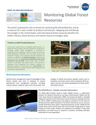
- 1. ã2017 California Institute of Technology. Government sponsorship acknowledged. NISAR: The NASA-ISRO SAR Mission Monitoring Forest Disturbance Optimal forest management requires knowledge of how forests change over time in response to natural disturbances and management activities, including invasive species; diseases; plant and animal pests; fire; changes in climate and serious weather events such as tornadoes, hurricanes and ice storms; pollution of the air, water, and soil; real estate development of forest lands; and timber harvest. Monitoring Global Forest Resources The world’s populations rely on forests for sustaining life and biodiversity, and as a resource for a vast number of products and services. Mapping and monitoring the changes in the United States’ and international forest resources benefits the timber industry, forest services, and natural resource managers alike. Forests as a Multi-Faceted Resource Forests have a pivotal role as a renewable natural resource. As demand for forest products and the competition for forest land is increasing, modern timber management is committed to sustainable forest management. Currently, timber has more than 30,000 applications worldwide. Also, non-timber products are harvested in forests, such as plants for food and medicines, fish and game. In addition to the productive function of forests, they have a central role in the protection and stabilization of the natural environment and real estate. Forests protect water resources, provide air purification, and reduce erosion. They are key to sustaining crucial biodiversity and enhance conditions for agricultural production. Forests also serve a social function as a recreational resource, an important labor market, living space, and they enhance national defense. The NISAR Mission – Reliable, Consistent Observations The NASA–ISRO Synthetic Aperture Radar (NISAR) mission, a collaboration between the National Aeronautics and Space Administration (NASA) and the Indian Space Research Organization (ISRO), will provide all-weather, day/night imaging of nearly the entire land and ice masses of the Earth repeated 4-6 times per month. NISAR’s orbiting radars will image at resolutions of 5-10 meters to identify and track subtle movement of the Earth’s land and its sea ice, and even provide information about what is happening below the surface. NISAR will also provide forest volume and biomass over time and with enough detail to reveal changes on human scales. Products are expected to be available 1-2 days after observation, and within hours in response to disasters, providing actionable, timely data for many applications. Image credits: U.S. Department of Agriculture and National Park Service
- 2. ã2017 California Institute of Technology. Government sponsorship acknowledged. Continued from front page With the world’s population critically dependent on sustainably managed and utilized forest resources, the need is greater now than ever before for the application of modern technology to provide detailed and timely informational map data to the timber industry, resource managers and forest policy makers. Satellite sensors provide synoptic views of the globe from space. This information is routinely used to guide policy both decision-makers and commercial interests. Examples include planning forest management activities, supporting preparation of information for forest real estate transactions domestically and in foreign countries, and monitoring the effects of forest policy changes, such as logging concessions or illegal logging activities. The upcoming NISAR mission will address these needs through a dependable observing strategy that will collect high resolution imagery over 90% of the Earth’s land surfaces. The use of actively generated microwave signals (L- and S-band, or equivalently, 24 cm and 10 cm wavelength) on board the satellite means that the observations will be able to be reliably planned, collected and distributed at time scales that are commensurate with the satellite’s 12- repeat cycle of the full set of orbits, which images each forest at least once every 6 days. Radar images from satellites, such as NISAR, are known for their ability to penetrate through clouds and their day/night imaging capability. Hence, even under near-perpetual dense tropical or frequent temperate cloud cover that are characteristics of global forest ecosystems, NISAR will provide bi-weekly observations that complement optical data and provide independent information that is sensitive to the mapping of forest disturbance, including below- canopy inundation from natural and catastrophic flooding events. National Aeronautics and Space Administration For more information, visit http://nisar.jpl.nasa.gov/applications Jet Propulsion Laboratory / California Institute of Technology / Pasadena, California / www.jpl.nasa.gov Image Data © JAXA/METI 2007-2009. Image Processing: Earth Big Data, LLC. Observations of the Earth’s land surfaces from space using active microwave sensors allows for reliable and repeated measurements to be made even under dense cloud cover. When forests canopies are disturbed, such that standing trees are partially or wholly felled or removed, or significant fractions of the upper canopy are lost, e.g. in a forest fire, the changes are reflected in a rich variety of radar signals that can be measured. The time history of changes shows when, where, and by how much the woods were altered. Shown at right are data collected by the Japanese ALOS satellite mission operating from 2006 to 2011. The image is a three-date color composite, where radar signatures result in color combinations that are directly related to various types of forest disturbance and regrowth. The NISAR mission will provide data of similar quality, yet at greater observation frequency and with easy data access by U.S. timber industry, natural resource managers, natural disaster prevention and response teams, researchers, and decision makers. The data will be a critical complement to the U.S. global land observing system by providing routine, global, cloud-free forest monitoring capacity. Three-date (2007, 2008, 2009) L-Band radar image of timber production land in southern Louisiana, one of the most intensive timber production areas of the United States. Red and yellow colors readily show various dates and intensities of forest management activities (clear-cut and selective logging). Blue and purple colors show areas and stage of re-growing forest plantations. Radar Imaging of Forest Disturbance