
Recomendados
Recomendados
Mais conteúdo relacionado
Mais procurados
Mais procurados (11)
Destaque
Destaque (12)
Semelhante a FinalProject
Semelhante a FinalProject (20)
FinalProject
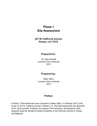
- 1. Phase 1 Site Assessment 321 W. California Avenue Ruston, LA 71272 Prepared for: Dr. Gary Zumwalt Louisiana Tech University 2015 Prepared by: Nolan Glenn Louisiana Tech University 2015 Preface A Phase 1 Site Assessment was conducted by Nolan Glenn, in February 2015, at the corner of 321 W. California Avenue in Ruston, LA. This Site Assessment was approved by Dr. Gary Zumwalt, Professor at Louisiana Tech University. All evaluations were prepared using the Standard Practice Guidelines of the American Society of Testing and Materials.
- 2. The assessment was conducted using the appropriate judgement in accordance with the guidelines given to him. The findings recorded in this assessment are appropriate to this specific property and the surrounding liabilities that may be associated with it. There may be other environmental risks that are not listed in this assessment and Nolan Glenn is not responsible for any unreported liabilities. Further testing may be required by the client after analyzing the report and understanding the liabilities. By: _______________________________ __________ Nolan Glenn, Environmental Science Student Date Phase 1 Field Inspector Louisiana Tech University Summary The 12 acre property of 321 W California Ave. was visited to inspect all parts of the property and the surrounding property. A full walk around the property was done first while recording any possible problems. Then, to ensure the entire boundary was inspected, the team used a spiral search pattern to cover more ground. The apparent and/or possible problem that were found at the site are listed below. To assist the reader in visualizing these problems the site map is provided on the following page and will be labelled according to the list below. 1
- 3. 1. Transformers with no PCB label 2. There is a patch of dirt that is used by the auto shop for parking. Vehicle tracks indicate frequent trips through the property where it was not intended. This also suggests gasoline leakage in that patch. 3. Parking lot used by 18 wheelers possibly carrying connate water. 4. There is an auto shop uphill from property which could possibly mean downgradient flow of vehicle fluids. 5. Site of past UST removal is found on the corner opposite of Taco Bell. There is an auto shop at this location currently. 6. A waterway drainage pipe is in the southwest corner of the property. On some visits to the site, there was trash in and around the pipe (see Appendix 7.4). 7. A railroad once passed through the north and south ends of the property. It is unknown what type of product was carried through the site. 8. There is a foundation in the southwest corner of the property that is unidentified. 9. An accumulation of vegetation is found all along the south border of the property. It was later discovered that this section of the site was once a series of buildings that included a cinema, a real estate office, a clothing store, a supermarket, and a drug store. No foundation is apparent however the possibility of remains is likely. 10.The waterway is downstream from an old fertilizer plant downtown. This plant has long been shut down but remains from the discharge may be harmful. 11.California Ave. runs along the northern border of the site and is the waste transport route. Recommendations: Addressing the environmental problems in this site will require various tests. Soil testing around the transformers will be required to search for any polychlorinated biphenyls. By law all transformers must now be labelled if there are no PCBs used in the electrical transformer. The two transformers in this property (one on the west end and one on the east end) lack the PCB label and therefore they could be potentially dangerous. The parking areas in this lot need to be sampled for any spilled contaminants. This is specifically important for the parking sites of 18 wheelers that could have spilled connate water. Another concern in regards to vehicle spillage is the dirt patch in the southeast corner. Samples will be needed to determine if any damaging fluids have entered the soil and to what extent. These samples can also measure to what extent the downgradient spillage occurs from the auto shop. 2
- 4. There were no USTs found on this site in any records. However, the auto shop on the corner diagonal from Taco Bell once held a LUST. It has since been removed from the site but the reason for removal was a widespread leak that could have possibly invaded the property and those surrounding it. It is therefore recommended to have samples taken from both the site of the LUST and the corner across from it. Lasting deposits could be left along the banks of the waterway through the west side of the property. It is recommended that multiple samples be taken along the sides of the water to test for any insecticide remains as well as any leaks from the gas line adjacent to it. When the agrochemical factory upstream from the site was still in operation, DDTs may not have been banned yet. It is also necessary to take samples along the waste transport route to calculate for any waste deposits. Table of Contents Preface .. . . . . . . . . . . . . . . . . . . . . . . . . . . . . . . . . . . . . . . . . . . . . . . . . .1 Summary.. . . . . . . . . . . . . . . . . . . . . . . . . . . . . . . . . . . . . . . . . . . . . . . . 2 Site Map.. . . . . . . . . . . . . . . . . . . . . . . . . . . . . . . . . . . . . . . . . . . . . . . . . 4 1.0 Scope.. . . . . . . . . . . . . . . . . . . . . . . . . . . . . . . . . . . . . . . . . . . . . . .6 1.1 Purpose . . . . . . . . . . . . . . . . . . . . . . . . . . . . . . . . . . . . . . . . . . . . . . .6 1.2 Objectives. . . . . . . . . . . . . . . . . . . . . . . . . . . . . . . . . . . . . . . . . . . . . .6 1.3 Considerations Beyond the Scope . . . . . . . . . . . . . . . . . . . . . . . . . . . . . .6 3
- 5. 1.4 Organization of This Practice. . . . . . . . . . . . . . . . . . . . . . . . . . . . . . . . . .6 2.0 Referenced Documents.. . . . . . . . . . . . . . . . . . . . . . . . . . . . . . . .7 2.0 ASTM Standards . . . . . . . . . . . . . . . . . . . . . . . . . . . . . . . . . . . . . . . . .7 3.0 Terminology.. . . . . . . . . . . . . . . . . . . . . . . . . . . . . . . . . . . . . . . . . 7 3.1 Definitions. . . . . . . . . . . . . . . . . . . . . . . . . . . . . . . . . . . . . . . . . . . . . .7 3.2 Acronyms. . . . . . . . . . . . . . . . . . . . . . . . . . . . . . . . . . . . . . . . . . . . . . 7 4.0 Significanceand Use. . . . . . . . . . . . . . . . . . . . . . . . . . . . . . . . . . 7 4.1 Uses. . . . . . . . . . . . . . . . . . . . . . . . . . . . . . . . . . . . . . . . . . . . . . . . . 7 4.2 Two Related Practices. . . . . . . . . . . . . . . . . . . . . . . . . . . . . . . . . . . . . .8 4.3 Additional Services. . . . . . . . . . . . . . . . . . . . . . . . . . . . . . . . . . . . . . . .8 4.4 Continued Viability of Environmental Site Assessment . . . . . . . . . . . . . . . . 8 4.5 Prior Assessment Usage . . . . . . . . . . . . . . . . . . . . . . . . . . . . . . . . . . .8 5.0 User’s Responsibility . . . . . . . . . . . . . . . . . . . . . . . . . . . . . . . . . 8 5.1 Scope . . . . . . . . . . . . . . . . . . . . . . . . . . . . . . . . . . . . . . . . . . . . . . . .8 5.2 Checking Title Records . . . . . . . . . . . . . . . . . . . . . . . . . . . . . . . . . . . .8 5.3 Specialized Knowledge or Experience of the User . . . . . . . . . . . . . . . . . . .9 6.0 Records Review.. . . . . . . . . . . . . . . . . . . . . . . . . . . . . . . . . . . . . 9 6.1 Introduction . . . . . . . . . . . . . . . . . . . . . . . . . . . . . . . . . . . . . . . . . . . .9 6.2 Environmental Information . . . . . . . . . . . . . . . . . . . . . . . . . . . . . . . . . .9 6.3 Historical Use Information . . . . . . . . . . . . . . . . . . . . . . . . . . . . . . . . . . 9 6.4 Prior Assessment Usage . . . . . . . . . . . . . . . . . . . . . . . . . . . . . . . . . . 10 7.0 Appendices . . . . . . . . . . . . . . . . . . . . . . . . . . . . . . . . . . . . . . . . . 11 7.1 Aerial Photos . . . . . . . . . . . . . . . . . . . . . . . . . . . . . . . . . . . . . . . . . . .12 7.2 Fire Map (1922) . . . . . . . . . . . . . . . . . . . . . . . . . . . . . . . . . . . . . . . . . 14 7.3 Historical Photos . . . . . . . . . . . . . . . . . . . . . . . . . . . . . . . . . . . . . . . . .15
- 6. 7.4 Site Reconnaissance Photos . . . . . . . . . . . . . . . . . . . . . . . . . . . . . . . . .15 7.5 Soil Map. . . . . . . . . . . . . . . . . . . . . . . . . . . . . . . . . . . . . . . . . . . . . . .17 7.6 East-West Geohydrologic Section. . . . . . . . . . . . . . . . . . . . . . . . . . . . . .18 1.0 Scope 1.1 Purpose The purpose of this document is to provide an accurate and detailed Phase I Environmental Site Assessment Process in accordance with ASTM standards. This means that all liabilities associated with the 321 W. California Avenue property will be reported and evaluated in accordance with the scope of CERCLA. Accomplishing this will allow for the client to determine if they would like to continue to pursue this property and if so, allow them to take remedial measures. 1.2 Objectives The clear objectives in this assessment are (1) to give the client a written document of all reported problems, (2) to provide visuals to aid the reader in understanding the problems, and (3) to give professional recommendations on how to clean up the problems. 1.3 Considerations Beyond the Scope The specific site in this assessment, and environmental conditions with it, are defined by the scope in this report. There may be some investigation that goes beyond the scope defined by the assessor if it is in relation to this property. Any additional off-site research must be agreed upon between the environmental professional and the client. 1.4 Organization of This Practice
- 7. This report follows a specific structure to ensure the reader can follow and understand the potential liabilities. This report first gives a summary of the property to openly address the problems found. A sitemap is given to help visualize the problems. Then, a detailed report follows this introduction with the scope of the assessment. The rest of the document follows standard Phase I Environmental Site Assessment Processes. It ends with appendices that include any referenced maps of photos. 2.0 Referenced Documents 2.1 ASTM Standards To emphasize accuracy, this document was written in reference to the ASTM Standards: E 1528 Practice for Environmental Site Assessment Transaction Screen Process 3.0 Terminology 3.1 Definitions liability- any environmental problem that is associated with the property can be legally applied to any current or past owners. basemap- a map of the property drawn by the site assessor that clearly shows all problems associated with the property cistern- an underground holding cell for liquid (usually water); often referred to as a well. 3.2 Acronyms ASTM- American Society for Testing and Materials CERCLA- Comprehensive Environmental Response, Compensation, and Liability Act UST- underground storage tank LUST- leaking underground storage tank PCB- polychlorinated biphenyls DDT- dichlorodiphenyltrichloroethane TB- Taco Bell 4.0 Significance and Use 6
- 8. 4.1 Uses The use of this practice is to refer to a professional analysis of the property of 321 W. California Avenue and those liabilities associated with it. It is understood and trusted that this practice took all aspects of the property and surrounding property into evaluation. This report is site-specific and is not mainly concerned with business history other than to confirm an environmental suspicion. 4.2 Two related Practices The two practices used in this assessment are the Phase I Site Assessment and the E 1528 Transaction Screen Process. Together these practices allow for an official document that follow legal standards. 4.3 Additional Services Some additional services may be desired by the client. It is therefore stated that further services may be conducted if agreed upon by the assessor and the client that address areas outside of this scope. 4.4 Continued Viability of Environmental Site Assessment The length to which this assessment is valid is defined by the ASTM Standards of 180 days. 4.5 Prior Assessment Usage This practices may be desired by previous owners or subsequent persons involved with this property to ensure legal awareness and appropriate liability information. 5.0 User’s Responsibility 5.1 Scope The purpose of this section is to define the responsibilities of the user of this practice. The person using these remediation strategies will need to familiarize themselves with the terminology used this report. No professional environmental knowledge will be necessary for the user to understand the implied environmental liabilities.
- 9. 5.2 Checking Title Records The environmental professional conducting this assessment is only required to report the possible problems. It is then recommended that the user request and obtain any titlerecords associated with the property. This will help to confirm any implications by the assessor as well as inform the user of any blatant land use limitations. 5.3 Specialized Knowledge or Experience of the User This section defines the responsibility of the user to communicate any specialized knowledge to the environmental professional. This specialized knowledge includes any previous information pertaining to the property that will assist the professional in conducting the assessment. Another example of this action would be if there were any safety hazards that the professional should know about prior to conducting the report. 6.0 Records Review 6.1 Introduction This section begins the specific evaluation of the 321 W. California Avenue site. There are historical records in this section to help support any reported liabilities. Many of these report have already been stated in the summary of this document but, they must be report to support the ASTM Standards. 6.2 Environmental Information The environmental uses of this property were researched as far back as 1922. This was done by using the Lincoln Parish GIS District website. This site included many historical maps as well as aerial view photos taken from the past (see Appendix 7.2). Additional environmental information about this site was found when researching the soil. Our team used the Web Soil Survey website to find that this property sits on a 12 acre Angie very fine sandy loam (see Appendix 7.5). 6.3 Historical Use Information The historical use of this property was determined using a fire map from 1922. This information was found on the Lincoln Parish GIS District website. This specific property once had a railroad running through from the north and south edges of the property. Further sample need to be taken to determine if any traces of this railway is left.
- 10. This website also showed a school on the west side of the property. A photo from 1922 was also given to show the exact location of the building. This fire map also shows more than 10 residential buildings in 1922 as well as 3 industrial buildings. The uses of these industrial buildings were not found in the research in this assessment (see Appendix 7.2). The south end ot the property was revealed to be a strip mall containing a cinema, a real estate office, a clothing store, a supermarket, and a drug store. This information was obtained from an interview with Dr. Zumwalt after class. Soil samples are recommended at these locations to test for improper chemical disposal. The property is currently occupied by a Taco Bell, a Dollar General, and a closed bank. It is also being used by a local auto shop business for parking. 6.4 Prior Assessment Usage The only prior assessment usage that was reported to the environmental professionals in this assessment was the knowledge of the stip mall on the southh end of the property. It was assumed to be a field of overgrown vegetation until the client (Dr. Zumwalt) informed the team that there used to be business there. 7.0 Appendices 7.1 Aerial Photos 10
- 11. most recent aerial view
- 12. aerial view from 1949 7.2 Fire Map (1922)
- 13. historical map created from fire maps (1922) 7.3 Historical Photos
- 14. historical school that stood on the property in 1922 7.4 Site Reconnaissance Photos view from the southeast corner of the property
- 15. view from south center of the site view of waterway drainage ditch 7.5 Soil Map