Great Smoky Mountain National Park- Cades Cove CampGround Map
1. Cades Cove
Campground Map
E X P E R I E N C E Y O U R A M E R I C A
NORTH
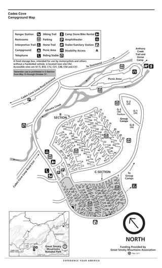
Ranger Station
Restrooms
Interpretive Trail
Campground
Telephone
Hiking Trail
Parking
Horse Trail
Picnic Area
Riding Stable
Camp Store/Bike Rental
Amphitheater
Trailer/Sanitary Station
Disability Access AA
1
3
5
7
11
13
15
17
19
2
4
6
8
10
12
14
16
18
20
22
24
26
28
30
32
34
36
38
40
42
44
21
23
25
27
29
31
33
35
37
39
41 43
45
47
49
51
53
55
57
59
61
63
65
67
46
48
50
52
54
56
58
60
62
64
66
68
69
71
73
75
77
79
81
83
70
72
74
76
78
80
84
85
1
2
3
4
5
6
7
8
9
29 101112 13
14
15
16
17
18
19
20
21
22
232425
262728
31
33
35
37
39
41
43
44
30
32
34
36
38
40
42
45
47
49
51
53
55
57
60
61
59
46
48
50
52
54
56
58
62
64
66
68
70
72
74
75
76
73
71
69
67
65
63
ea
Cades Cove Loop Road Entrance
To Townsend
Group
Camps
G-3
(30)
Pavilion
G-2
(20)
G-1
(20)
G-4
(30)
To
Group
Camps
C-SECTION
B
SECTION
Abrams Creek
CadesCove
Loop
Road
Exit
oneway
oneway
oneway
oneway
one
w
ay
one
w
ay
one
w
ay
Funding Provided by
Great Smoky Mountains Association0 1
miles
Great Smoky
Mountains
National Park
North
4A
5A
3A
2A
1A
Cades Cove
Campground Map
Generator use is prohibited in C-Section
from May 15 through October 31.
Rev. 2/11
Anthony
Creek
Trail and
Horse
Camp
Picnic Ar
A food storage box, intended for use by motorcyclists and others
without a hardsided vehicle, is located near site C42.
Accessible sites are A1-5, B33, C12, C31, C48, C50 and C57.