SlideShare uma empresa Scribd logo
1 de 1
Baixar para ler offline
Acknowledgement -
The author is grateful to the staff of NASA Dryden Flight Center facility, in particular Meteorology Team Edward Teets, Franzeska F Houtas,
and Scott Davis. Special thanks to Christopher Busby for coding help among other things. The data was collected by the NCCS at Goddard.
The author also thank STAR program through Cal Poly for the opportunity and the support.
Earth’s Atmosphere, Altitude, and Water Vapor
Existence:
Earth’s atmosphere reaches over 600 km (≈2 million ft)
from the surface of the Earth. Only the lower atmospheric
layer, Troposphere, contains the most of water vapor.
This is the reason why SOFIA is flying above the
Troposphere.
Formulae to Calculate Water Vapor Loading
Where 980.616 = acceleration of gravity (cm/s^2)
W = mixing ratio in grams per kilogram
P = pressure (millibars)
i = index ranging from the surface to the current level
Tool – weather balloon atmospheric global model:
A weather balloon is used to measure the
atmospheric parameter of pressure, temperature,
humidity, and wind speed in the atmosphere. In order
to obtain wind data, it is tracked by radar or
navigation system, such as satellite based Global
Positioning System (GPS).
Filling up the weather balloon in Mojave desert in NASA Spaceward
Bound 2010, Zzyzxrd, CA
Resources:
Roberts, E. R., Biberman, L. M., Selby, J. E.A. (1976). Infrared Continuum Absorption by Atmospheric Water Vapor in the 8 – 12 µm Window. Institute for Defense Analyses
science and Technology Division, paper P-1134
Varanais, P., Prasad, C.R. (1998). Measurement of Absorption Characteristics of Water Vapor Near Saturation, Climate Research Facility, 777.
http://www.nasa.gov/mission_pages/SOFIA/page2new_rd.html
http://en.wikipedia.org/wiki/Water_vapor#Water_vapor_in_Earth.27s_atmosphere
Results & Discussion:
Most of the upper air data provided in the United States are taken by the weather
balloons. However, there isn’t a lot data from the ocean.
Once the flying region of SOFIA expands globally, water vapor loading in the
atmosphere may become a concern because of the lack of measurements of
atmospheric parameters needed to calculate water vapor loading.
With more satellites being added to the space constellation and many to provide
data on the earths atmosphere, it won’t be long until satellites will be an additional
source of atmospheric data.
Conclusion:
•SOFIA may need to fly higher in order to reduce water vapor loading
under 20μm.
•There is always a difference between model and actual data.
•Data from the model will be used to determine the amount of water
vapor loading from the aircraft flight level to the top of the model (75km).
When the project is completed, it will provide an alternative atmospheric
profile along the trajectory with the water vapor loading highlights.
Christopher’s contribution: list
the atmospheric parameter and
show the path of the flight.
About SOFIA:
The world largest airborne observatory that will complement the Hubble, Spitzer, Herschel and James Webb
space telescopes and major Earth-based telescopes. It’ll provide better image quality and vastly increased
observational sensitivity.
a joint program by NASA and DLR (German Aerospace Center).
It is based out of NASA Dryden Palmdale Facility and will be flying globally.
NASA's Stratospheric Observatory for Infrared Astronomy 747SP reached a milestone Dec. 18, 2009,
when the doors covering the aircraft's German-built infrared astronomy telescope were fully opened
during flight. Dec. 18, 2009
NASA Photo / Carla Thomas
http://www.nasa.gov/mission_pages/SOFIA/multimedia/imagegallery/index.html#
With a protective cover over its primary mirror, the high-tech German-built infrared telescope is nested in its framework
inside the 19-foot-deep, 12-foot-wide telescope cavity in the rear fuselage of NASA's SOFIA flying observatory. April 20,
2010 NASA Photo / Tom Tschida
http://www.nasa.gov/mission_pages/SOFIA/multimedia/imagegallery/index.html#
Our mission:
Is to accurately predict the water vapor loading is in the atmosphere which may further designate
trajectory of SOFIA in order to have the best results in infrared astronomy observation.
The role of Water Vapor absorption in IR Astronomy
Water vapor = greenhouse gas, absorbs IR energy and re-emits the
energy in all direction.
Strong absorbance by water vapor occurs at wavelengths around 2900,
1950, and 1450 (nm), with other absorption all in the infrared
spectrum.
*Important* small percentage of water vapor in the atmosphere can
still have a large influence on infrared absorption
The effect of water vapor absorption is important consideration because
infrared astronomy is detecting infrared radiation emission.
Method
•The current atmospheric model used for this project is the Global atmosphere
model ( Goddard Earth Observing System Model, Version 5(GEOS-5))from NASA
Goddard Space Flight Center to determine the water loading.
•This is the comparison of two data sources: GEOS-5 (High Resolution as 0.5°
latitude, 0.66° longitude ) v.s. Actual Sounding Data (@ U. of Wyoming as 2°
latitude, 2° longitude )
GEOS-5 vs. Actual Data from Wyoming WVL Above SOFIA flying range775 km(2483ft)
from GEOS5 & Wyoming
WVL Above SOFIA flying range11.5 km (38000ft)
from GEOS5 & Wyoming
WVL Above SOFIA flying range13.1 km (41000ft)
from GEOS5 & Wyoming
Simulated data along a flight path from
Florida to Alaska.
Actual data from SOFIA and its flight path.


 
1
11 )()(
616.980
5 i
i
iiii PPWWLoadingVaporWater

Mais conteúdo relacionado

Mais procurados

TU2.L10 - THE AQUARIUS/SAC-D MISSION OVERVIEW
TU2.L10 - THE AQUARIUS/SAC-D MISSION OVERVIEWTU2.L10 - THE AQUARIUS/SAC-D MISSION OVERVIEW
TU2.L10 - THE AQUARIUS/SAC-D MISSION OVERVIEWgrssieee
 
Meterological Technology International, Nov 2010
Meterological Technology International, Nov 2010Meterological Technology International, Nov 2010
Meterological Technology International, Nov 2010laurajairam
 
Seismic reflection at lang kawi
Seismic reflection at lang kawiSeismic reflection at lang kawi
Seismic reflection at lang kawiAmin khalil
 
TU2.L10 - NEXT-GENERATION GLOBAL PRECIPITATION PRODUCTS AND THEIR APPLICATIONS
TU2.L10 - NEXT-GENERATION GLOBAL PRECIPITATION PRODUCTS AND THEIR APPLICATIONSTU2.L10 - NEXT-GENERATION GLOBAL PRECIPITATION PRODUCTS AND THEIR APPLICATIONS
TU2.L10 - NEXT-GENERATION GLOBAL PRECIPITATION PRODUCTS AND THEIR APPLICATIONSgrssieee
 
IUKWC Workshop Nov16: Developing Hydro-climatic Services for Water Security –...
IUKWC Workshop Nov16: Developing Hydro-climatic Services for Water Security –...IUKWC Workshop Nov16: Developing Hydro-climatic Services for Water Security –...
IUKWC Workshop Nov16: Developing Hydro-climatic Services for Water Security –...India UK Water Centre (IUKWC)
 
Meteorological Satellites
Meteorological SatellitesMeteorological Satellites
Meteorological SatellitesManoj Barman
 
Envi sat satellite
Envi sat satelliteEnvi sat satellite
Envi sat satelliteEhsanYousaf1
 
170123Seattle_AMS_OLYMPEXposter_Rowe
170123Seattle_AMS_OLYMPEXposter_Rowe170123Seattle_AMS_OLYMPEXposter_Rowe
170123Seattle_AMS_OLYMPEXposter_RoweMegan Chaplin
 
A highly magnetized twin-jet base pinpoints a supermassive black hole
A highly magnetized twin-jet base pinpoints a supermassive black holeA highly magnetized twin-jet base pinpoints a supermassive black hole
A highly magnetized twin-jet base pinpoints a supermassive black holeSérgio Sacani
 
TU4.T10.4.pptx
TU4.T10.4.pptxTU4.T10.4.pptx
TU4.T10.4.pptxgrssieee
 
Remote Sensing Methods for operational ET determinations in the NENA region, ...
Remote Sensing Methods for operational ET determinations in the NENA region, ...Remote Sensing Methods for operational ET determinations in the NENA region, ...
Remote Sensing Methods for operational ET determinations in the NENA region, ...NENAwaterscarcity
 
Time integration of evapotranspiration using a two source surface energy bala...
Time integration of evapotranspiration using a two source surface energy bala...Time integration of evapotranspiration using a two source surface energy bala...
Time integration of evapotranspiration using a two source surface energy bala...Ramesh Dhungel
 
Presentation on Aerosols, cloud properties
Presentation on Aerosols, cloud properties Presentation on Aerosols, cloud properties
Presentation on Aerosols, cloud properties Esayas Meresa
 
TIME INTEGRATION OF EVAPOTRANSPIRATION USING A TWO SOURCE SURFACE ENERGY BALA...
TIME INTEGRATION OF EVAPOTRANSPIRATION USING A TWO SOURCE SURFACE ENERGY BALA...TIME INTEGRATION OF EVAPOTRANSPIRATION USING A TWO SOURCE SURFACE ENERGY BALA...
TIME INTEGRATION OF EVAPOTRANSPIRATION USING A TWO SOURCE SURFACE ENERGY BALA...Ramesh Dhungel
 
2013 ASPRS Track, Developing an ArcGIS Toolbox for Estimating EvapoTranspirat...
2013 ASPRS Track, Developing an ArcGIS Toolbox for Estimating EvapoTranspirat...2013 ASPRS Track, Developing an ArcGIS Toolbox for Estimating EvapoTranspirat...
2013 ASPRS Track, Developing an ArcGIS Toolbox for Estimating EvapoTranspirat...GIS in the Rockies
 
Galaxy dynamics and the mass density of the universe
Galaxy dynamics and the mass density of the universeGalaxy dynamics and the mass density of the universe
Galaxy dynamics and the mass density of the universeSérgio Sacani
 

Mais procurados (20)

TU2.L10 - THE AQUARIUS/SAC-D MISSION OVERVIEW
TU2.L10 - THE AQUARIUS/SAC-D MISSION OVERVIEWTU2.L10 - THE AQUARIUS/SAC-D MISSION OVERVIEW
TU2.L10 - THE AQUARIUS/SAC-D MISSION OVERVIEW
 
Meterological Technology International, Nov 2010
Meterological Technology International, Nov 2010Meterological Technology International, Nov 2010
Meterological Technology International, Nov 2010
 
Seismic reflection at lang kawi
Seismic reflection at lang kawiSeismic reflection at lang kawi
Seismic reflection at lang kawi
 
GPS Orbits
GPS OrbitsGPS Orbits
GPS Orbits
 
TU2.L10 - NEXT-GENERATION GLOBAL PRECIPITATION PRODUCTS AND THEIR APPLICATIONS
TU2.L10 - NEXT-GENERATION GLOBAL PRECIPITATION PRODUCTS AND THEIR APPLICATIONSTU2.L10 - NEXT-GENERATION GLOBAL PRECIPITATION PRODUCTS AND THEIR APPLICATIONS
TU2.L10 - NEXT-GENERATION GLOBAL PRECIPITATION PRODUCTS AND THEIR APPLICATIONS
 
IUKWC Workshop Nov16: Developing Hydro-climatic Services for Water Security –...
IUKWC Workshop Nov16: Developing Hydro-climatic Services for Water Security –...IUKWC Workshop Nov16: Developing Hydro-climatic Services for Water Security –...
IUKWC Workshop Nov16: Developing Hydro-climatic Services for Water Security –...
 
Meteorological Satellites
Meteorological SatellitesMeteorological Satellites
Meteorological Satellites
 
Presentation
PresentationPresentation
Presentation
 
FLARE_Brief
FLARE_BriefFLARE_Brief
FLARE_Brief
 
Envi sat satellite
Envi sat satelliteEnvi sat satellite
Envi sat satellite
 
AGU_Poster_Fahringer
AGU_Poster_FahringerAGU_Poster_Fahringer
AGU_Poster_Fahringer
 
170123Seattle_AMS_OLYMPEXposter_Rowe
170123Seattle_AMS_OLYMPEXposter_Rowe170123Seattle_AMS_OLYMPEXposter_Rowe
170123Seattle_AMS_OLYMPEXposter_Rowe
 
A highly magnetized twin-jet base pinpoints a supermassive black hole
A highly magnetized twin-jet base pinpoints a supermassive black holeA highly magnetized twin-jet base pinpoints a supermassive black hole
A highly magnetized twin-jet base pinpoints a supermassive black hole
 
TU4.T10.4.pptx
TU4.T10.4.pptxTU4.T10.4.pptx
TU4.T10.4.pptx
 
Remote Sensing Methods for operational ET determinations in the NENA region, ...
Remote Sensing Methods for operational ET determinations in the NENA region, ...Remote Sensing Methods for operational ET determinations in the NENA region, ...
Remote Sensing Methods for operational ET determinations in the NENA region, ...
 
Time integration of evapotranspiration using a two source surface energy bala...
Time integration of evapotranspiration using a two source surface energy bala...Time integration of evapotranspiration using a two source surface energy bala...
Time integration of evapotranspiration using a two source surface energy bala...
 
Presentation on Aerosols, cloud properties
Presentation on Aerosols, cloud properties Presentation on Aerosols, cloud properties
Presentation on Aerosols, cloud properties
 
TIME INTEGRATION OF EVAPOTRANSPIRATION USING A TWO SOURCE SURFACE ENERGY BALA...
TIME INTEGRATION OF EVAPOTRANSPIRATION USING A TWO SOURCE SURFACE ENERGY BALA...TIME INTEGRATION OF EVAPOTRANSPIRATION USING A TWO SOURCE SURFACE ENERGY BALA...
TIME INTEGRATION OF EVAPOTRANSPIRATION USING A TWO SOURCE SURFACE ENERGY BALA...
 
2013 ASPRS Track, Developing an ArcGIS Toolbox for Estimating EvapoTranspirat...
2013 ASPRS Track, Developing an ArcGIS Toolbox for Estimating EvapoTranspirat...2013 ASPRS Track, Developing an ArcGIS Toolbox for Estimating EvapoTranspirat...
2013 ASPRS Track, Developing an ArcGIS Toolbox for Estimating EvapoTranspirat...
 
Galaxy dynamics and the mass density of the universe
Galaxy dynamics and the mass density of the universeGalaxy dynamics and the mass density of the universe
Galaxy dynamics and the mass density of the universe
 

Destaque

"VISITA A SECHURA-MANGLARES DE SAN PEDRO I.E.AMERICANO"
"VISITA A SECHURA-MANGLARES DE SAN PEDRO I.E.AMERICANO""VISITA A SECHURA-MANGLARES DE SAN PEDRO I.E.AMERICANO"
"VISITA A SECHURA-MANGLARES DE SAN PEDRO I.E.AMERICANO"I.E.P Americano
 
Organizacion de los tribunales agrario
Organizacion de los tribunales agrarioOrganizacion de los tribunales agrario
Organizacion de los tribunales agrarioLuanse Gómez
 
Plan Vacacional Inversiones Porcina
Plan Vacacional Inversiones PorcinaPlan Vacacional Inversiones Porcina
Plan Vacacional Inversiones PorcinaCalidad de Vida
 
6A - A dengue evelyn e beatriz vitória
6A - A dengue evelyn e beatriz vitória6A - A dengue evelyn e beatriz vitória
6A - A dengue evelyn e beatriz vitóriaviannota
 
Registral y notarial marisela
Registral y notarial mariselaRegistral y notarial marisela
Registral y notarial mariselaWilmary Gonzalez
 
Abhishek Resume
Abhishek ResumeAbhishek Resume
Abhishek ResumeInfosys
 
"The Modern Concept of History"
"The Modern Concept of History""The Modern Concept of History"
"The Modern Concept of History"akatzkinko
 
SAP TechED Las Vegas 2016- OEM Partners- SAP HANA Cloud Platform Agenda
SAP TechED Las Vegas 2016- OEM Partners- SAP HANA Cloud Platform AgendaSAP TechED Las Vegas 2016- OEM Partners- SAP HANA Cloud Platform Agenda
SAP TechED Las Vegas 2016- OEM Partners- SAP HANA Cloud Platform AgendaShivakumar Vishwanath
 

Destaque (16)

"VISITA A SECHURA-MANGLARES DE SAN PEDRO I.E.AMERICANO"
"VISITA A SECHURA-MANGLARES DE SAN PEDRO I.E.AMERICANO""VISITA A SECHURA-MANGLARES DE SAN PEDRO I.E.AMERICANO"
"VISITA A SECHURA-MANGLARES DE SAN PEDRO I.E.AMERICANO"
 
Organizacion de los tribunales agrario
Organizacion de los tribunales agrarioOrganizacion de los tribunales agrario
Organizacion de los tribunales agrario
 
Plan Vacacional Inversiones Porcina
Plan Vacacional Inversiones PorcinaPlan Vacacional Inversiones Porcina
Plan Vacacional Inversiones Porcina
 
6A - A dengue evelyn e beatriz vitória
6A - A dengue evelyn e beatriz vitória6A - A dengue evelyn e beatriz vitória
6A - A dengue evelyn e beatriz vitória
 
Registral y notarial marisela
Registral y notarial mariselaRegistral y notarial marisela
Registral y notarial marisela
 
Acuerdo CapacitacióN
Acuerdo CapacitacióNAcuerdo CapacitacióN
Acuerdo CapacitacióN
 
Notam2
Notam2Notam2
Notam2
 
Padre De Familia
Padre De FamiliaPadre De Familia
Padre De Familia
 
9
99
9
 
Abhishek Resume
Abhishek ResumeAbhishek Resume
Abhishek Resume
 
"The Modern Concept of History"
"The Modern Concept of History""The Modern Concept of History"
"The Modern Concept of History"
 
Zeytin
ZeytinZeytin
Zeytin
 
Donación de órganos
Donación de órganosDonación de órganos
Donación de órganos
 
Italy
Italy Italy
Italy
 
SAP TechED Las Vegas 2016- OEM Partners- SAP HANA Cloud Platform Agenda
SAP TechED Las Vegas 2016- OEM Partners- SAP HANA Cloud Platform AgendaSAP TechED Las Vegas 2016- OEM Partners- SAP HANA Cloud Platform Agenda
SAP TechED Las Vegas 2016- OEM Partners- SAP HANA Cloud Platform Agenda
 
Aprenem a navegar (mestre)
Aprenem a navegar (mestre)Aprenem a navegar (mestre)
Aprenem a navegar (mestre)
 

Semelhante a Dryden2011Poster

Embedded Audio_Video OCO-2 Clips
Embedded Audio_Video OCO-2 ClipsEmbedded Audio_Video OCO-2 Clips
Embedded Audio_Video OCO-2 ClipsStefano Coledan
 
Dare for planetaryexploration
Dare for planetaryexplorationDare for planetaryexploration
Dare for planetaryexplorationClifford Stone
 
Airships as an Earth and Space Science Platform - Jason Rhodes
Airships as an Earth and Space Science Platform - Jason RhodesAirships as an Earth and Space Science Platform - Jason Rhodes
Airships as an Earth and Space Science Platform - Jason RhodesAdvanced-Concepts-Team
 
Describe and explain satellite remote sensing mission for monitoring.pdf
Describe and explain satellite remote sensing mission for monitoring.pdfDescribe and explain satellite remote sensing mission for monitoring.pdf
Describe and explain satellite remote sensing mission for monitoring.pdfalshaikhkhanzariarts
 
PROBING FOR EVIDENCE OF PLUMES ON EUROPA WITH HST/STIS
PROBING FOR EVIDENCE OF PLUMES ON EUROPA WITH HST/STISPROBING FOR EVIDENCE OF PLUMES ON EUROPA WITH HST/STIS
PROBING FOR EVIDENCE OF PLUMES ON EUROPA WITH HST/STISSérgio Sacani
 
The 2013 NRC Decadal Survey in Solar and Space Physics (Heliophysics)
The 2013 NRC Decadal Survey in Solar and Space Physics (Heliophysics)The 2013 NRC Decadal Survey in Solar and Space Physics (Heliophysics)
The 2013 NRC Decadal Survey in Solar and Space Physics (Heliophysics)Art Charo
 
Retrieval & monitoring of atmospheric green house gases (gh gs) through remot...
Retrieval & monitoring of atmospheric green house gases (gh gs) through remot...Retrieval & monitoring of atmospheric green house gases (gh gs) through remot...
Retrieval & monitoring of atmospheric green house gases (gh gs) through remot...debasishagri
 
TH3.L10.1: THE NASA SOIL MOISTURE ACTIVE PASSIVE (SMAP) MISSION: OVERVIEW
TH3.L10.1: THE NASA SOIL MOISTURE ACTIVE PASSIVE (SMAP) MISSION: OVERVIEWTH3.L10.1: THE NASA SOIL MOISTURE ACTIVE PASSIVE (SMAP) MISSION: OVERVIEW
TH3.L10.1: THE NASA SOIL MOISTURE ACTIVE PASSIVE (SMAP) MISSION: OVERVIEWgrssieee
 
Weather how to read the weather maps 6.3
Weather how to read the weather maps 6.3Weather how to read the weather maps 6.3
Weather how to read the weather maps 6.3Kella Randolph
 
Butterfly Satellite Mission Overview
Butterfly Satellite Mission OverviewButterfly Satellite Mission Overview
Butterfly Satellite Mission OverviewChelle Gentemann
 

Semelhante a Dryden2011Poster (20)

Microwave remote sensing
Microwave remote sensingMicrowave remote sensing
Microwave remote sensing
 
Embedded Audio_Video OCO-2 Clips
Embedded Audio_Video OCO-2 ClipsEmbedded Audio_Video OCO-2 Clips
Embedded Audio_Video OCO-2 Clips
 
915 pankine[1]
915 pankine[1]915 pankine[1]
915 pankine[1]
 
Poster_jayson_v3
Poster_jayson_v3Poster_jayson_v3
Poster_jayson_v3
 
Dare for planetaryexploration
Dare for planetaryexplorationDare for planetaryexploration
Dare for planetaryexploration
 
Airships as an Earth and Space Science Platform - Jason Rhodes
Airships as an Earth and Space Science Platform - Jason RhodesAirships as an Earth and Space Science Platform - Jason Rhodes
Airships as an Earth and Space Science Platform - Jason Rhodes
 
Describe and explain satellite remote sensing mission for monitoring.pdf
Describe and explain satellite remote sensing mission for monitoring.pdfDescribe and explain satellite remote sensing mission for monitoring.pdf
Describe and explain satellite remote sensing mission for monitoring.pdf
 
PROBING FOR EVIDENCE OF PLUMES ON EUROPA WITH HST/STIS
PROBING FOR EVIDENCE OF PLUMES ON EUROPA WITH HST/STISPROBING FOR EVIDENCE OF PLUMES ON EUROPA WITH HST/STIS
PROBING FOR EVIDENCE OF PLUMES ON EUROPA WITH HST/STIS
 
6%2E2017-2021
6%2E2017-20216%2E2017-2021
6%2E2017-2021
 
Nock nov99
Nock nov99Nock nov99
Nock nov99
 
The 2013 NRC Decadal Survey in Solar and Space Physics (Heliophysics)
The 2013 NRC Decadal Survey in Solar and Space Physics (Heliophysics)The 2013 NRC Decadal Survey in Solar and Space Physics (Heliophysics)
The 2013 NRC Decadal Survey in Solar and Space Physics (Heliophysics)
 
Retrieval & monitoring of atmospheric green house gases (gh gs) through remot...
Retrieval & monitoring of atmospheric green house gases (gh gs) through remot...Retrieval & monitoring of atmospheric green house gases (gh gs) through remot...
Retrieval & monitoring of atmospheric green house gases (gh gs) through remot...
 
Haris Haralambous
Haris HaralambousHaris Haralambous
Haris Haralambous
 
TH3.L10.1: THE NASA SOIL MOISTURE ACTIVE PASSIVE (SMAP) MISSION: OVERVIEW
TH3.L10.1: THE NASA SOIL MOISTURE ACTIVE PASSIVE (SMAP) MISSION: OVERVIEWTH3.L10.1: THE NASA SOIL MOISTURE ACTIVE PASSIVE (SMAP) MISSION: OVERVIEW
TH3.L10.1: THE NASA SOIL MOISTURE ACTIVE PASSIVE (SMAP) MISSION: OVERVIEW
 
Weather how to read the weather maps 6.3
Weather how to read the weather maps 6.3Weather how to read the weather maps 6.3
Weather how to read the weather maps 6.3
 
Semester Project
Semester ProjectSemester Project
Semester Project
 
PARABLE POSTER
PARABLE POSTERPARABLE POSTER
PARABLE POSTER
 
2003 cospar casey
2003 cospar casey2003 cospar casey
2003 cospar casey
 
Sofia astronomy
Sofia astronomySofia astronomy
Sofia astronomy
 
Butterfly Satellite Mission Overview
Butterfly Satellite Mission OverviewButterfly Satellite Mission Overview
Butterfly Satellite Mission Overview
 

Dryden2011Poster

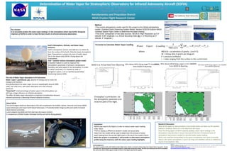
  • 1. Acknowledgement - The author is grateful to the staff of NASA Dryden Flight Center facility, in particular Meteorology Team Edward Teets, Franzeska F Houtas, and Scott Davis. Special thanks to Christopher Busby for coding help among other things. The data was collected by the NCCS at Goddard. The author also thank STAR program through Cal Poly for the opportunity and the support. Earth’s Atmosphere, Altitude, and Water Vapor Existence: Earth’s atmosphere reaches over 600 km (≈2 million ft) from the surface of the Earth. Only the lower atmospheric layer, Troposphere, contains the most of water vapor. This is the reason why SOFIA is flying above the Troposphere. Formulae to Calculate Water Vapor Loading Where 980.616 = acceleration of gravity (cm/s^2) W = mixing ratio in grams per kilogram P = pressure (millibars) i = index ranging from the surface to the current level Tool – weather balloon atmospheric global model: A weather balloon is used to measure the atmospheric parameter of pressure, temperature, humidity, and wind speed in the atmosphere. In order to obtain wind data, it is tracked by radar or navigation system, such as satellite based Global Positioning System (GPS). Filling up the weather balloon in Mojave desert in NASA Spaceward Bound 2010, Zzyzxrd, CA Resources: Roberts, E. R., Biberman, L. M., Selby, J. E.A. (1976). Infrared Continuum Absorption by Atmospheric Water Vapor in the 8 – 12 µm Window. Institute for Defense Analyses science and Technology Division, paper P-1134 Varanais, P., Prasad, C.R. (1998). Measurement of Absorption Characteristics of Water Vapor Near Saturation, Climate Research Facility, 777. http://www.nasa.gov/mission_pages/SOFIA/page2new_rd.html http://en.wikipedia.org/wiki/Water_vapor#Water_vapor_in_Earth.27s_atmosphere Results & Discussion: Most of the upper air data provided in the United States are taken by the weather balloons. However, there isn’t a lot data from the ocean. Once the flying region of SOFIA expands globally, water vapor loading in the atmosphere may become a concern because of the lack of measurements of atmospheric parameters needed to calculate water vapor loading. With more satellites being added to the space constellation and many to provide data on the earths atmosphere, it won’t be long until satellites will be an additional source of atmospheric data. Conclusion: •SOFIA may need to fly higher in order to reduce water vapor loading under 20μm. •There is always a difference between model and actual data. •Data from the model will be used to determine the amount of water vapor loading from the aircraft flight level to the top of the model (75km). When the project is completed, it will provide an alternative atmospheric profile along the trajectory with the water vapor loading highlights. Christopher’s contribution: list the atmospheric parameter and show the path of the flight. About SOFIA: The world largest airborne observatory that will complement the Hubble, Spitzer, Herschel and James Webb space telescopes and major Earth-based telescopes. It’ll provide better image quality and vastly increased observational sensitivity. a joint program by NASA and DLR (German Aerospace Center). It is based out of NASA Dryden Palmdale Facility and will be flying globally. NASA's Stratospheric Observatory for Infrared Astronomy 747SP reached a milestone Dec. 18, 2009, when the doors covering the aircraft's German-built infrared astronomy telescope were fully opened during flight. Dec. 18, 2009 NASA Photo / Carla Thomas http://www.nasa.gov/mission_pages/SOFIA/multimedia/imagegallery/index.html# With a protective cover over its primary mirror, the high-tech German-built infrared telescope is nested in its framework inside the 19-foot-deep, 12-foot-wide telescope cavity in the rear fuselage of NASA's SOFIA flying observatory. April 20, 2010 NASA Photo / Tom Tschida http://www.nasa.gov/mission_pages/SOFIA/multimedia/imagegallery/index.html# Our mission: Is to accurately predict the water vapor loading is in the atmosphere which may further designate trajectory of SOFIA in order to have the best results in infrared astronomy observation. The role of Water Vapor absorption in IR Astronomy Water vapor = greenhouse gas, absorbs IR energy and re-emits the energy in all direction. Strong absorbance by water vapor occurs at wavelengths around 2900, 1950, and 1450 (nm), with other absorption all in the infrared spectrum. *Important* small percentage of water vapor in the atmosphere can still have a large influence on infrared absorption The effect of water vapor absorption is important consideration because infrared astronomy is detecting infrared radiation emission. Method •The current atmospheric model used for this project is the Global atmosphere model ( Goddard Earth Observing System Model, Version 5(GEOS-5))from NASA Goddard Space Flight Center to determine the water loading. •This is the comparison of two data sources: GEOS-5 (High Resolution as 0.5° latitude, 0.66° longitude ) v.s. Actual Sounding Data (@ U. of Wyoming as 2° latitude, 2° longitude ) GEOS-5 vs. Actual Data from Wyoming WVL Above SOFIA flying range775 km(2483ft) from GEOS5 & Wyoming WVL Above SOFIA flying range11.5 km (38000ft) from GEOS5 & Wyoming WVL Above SOFIA flying range13.1 km (41000ft) from GEOS5 & Wyoming Simulated data along a flight path from Florida to Alaska. Actual data from SOFIA and its flight path.     1 11 )()( 616.980 5 i i iiii PPWWLoadingVaporWater