LTC, Annual Forum, Greener California: Impacts of Senate Bill 375 and Winning Strategies for Southern California, 05/22/2009, Boykin Witherspoon
•
1 gostou•195 visualizações

Boykin Witherspoon III; Center for Geographic Information Science Research, Cal Poly Pomona

Recomendados
Recomendados
Mais conteúdo relacionado
Destaque
Destaque (20)
Mais de LTC @ CSUSB
Mais de LTC @ CSUSB (20)
Último
Último (20)
LTC, Annual Forum, Greener California: Impacts of Senate Bill 375 and Winning Strategies for Southern California, 05/22/2009, Boykin Witherspoon
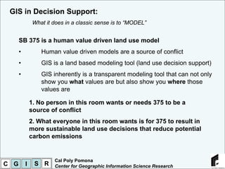
- 1. GIS in Decision Support: What it does in a classic sense is to “MODEL” SB 375 is a human value driven land use model • Human value driven models are a source of conflict • GIS is a land based modeling tool (land use decision support) • GIS inherently is a transparent modeling tool that can not only show you what values are but also show you where those values are 1. No person in this room wants or needs 375 to be a source of conflict 2. What everyone in this room wants is for 375 to result in more sustainable land use decisions that reduce potential carbon emissions Cal Poly Pomona C G I S R Center for Geographic Information Science Research
- 2. GIS in Decision Support: The fundamental GIS models, Overlay and Attribute GIS overlay modeling, all 6 maps are represented as one map http://www.suitabilitymap.org/ Cal Poly Pomona C G I S R Center for Geographic Information Science Research
- 3. GIS in Decision Support: The fundamental GIS models, Overlay and Attribute Cal Poly Pomona C G I S R Center for Geographic Information Science Research
- 4. GIS in Decision Support: 1 2 Case Study Map of: Alluvial Fan Flooding Zones / AFTF LCU Land Class Unit 1 3 4 Active Infrequent 5 8 Low Multi Hazard Value GIS Medium Beneficial Value 9 6 Overlay Suggested Practices for LCU 1 7 1 Modeling Planning Scale 2 Housing density ratio 3 Roadway alignment 4 LCU_NAME 5 Conveyance thresholds 8 Early warning systems active LCU_1 Site Scale 1 9 6 active-infreq Pile supported structure 2 Grading with existing topography not-active LCU_2 7 3 4 use of natural material 5 disturbed baseboards to foundation 8 scour protection 9 6 LCU_3 LCU_4 Land Class Unit 2 7 Active S t hw H LCU_5 a t ay ig High Multi Hazard Value e High Beneficial Value LCU_8 Suggested practices for LCU 2 LCU_9 Planning Scale High conveyance thresholds LCU_6 Passive land use Early warning systems 1 Aquifer recharge 2 Habitat 3 4 Site Scale LCU_7 No grading 5 8 Permeable paving 9 Use of natural material 6 Use of local plants 7 0 0.15 0.3 0.6 Miles Cal Poly Pomona C G I S R Center for Geographic Information Science Research
- 5. GIS in Decision Support: The fundamental GIS models, Overlay and Attribute Dr S.L. Cutter Social Vulnerability Index for California The index synthesizes 42 socioeconomic and built environment variables Cal Poly Pomona C G I S R Center for Geographic Information Science Research
- 6. GIS in Decision Support: The fundamental GIS models, Overlay and Attribute in action GIS decision support example: http://www.ranchocucamongaprospector.com/ed .asp?bhcp=1 Overlays a neighborhood size buffer polygon based on drive time from a point location with parcel level polygons and tax assessors attribute data Parcel Map 1 Cal Poly Pomona C G I S R Center for Geographic Information Science Research