Travis Armbrister Thesis project (2016 Department of Architecture alumni)
•
1 gostou•5,168 visualizações

The following work was developed by 2016 Architecture alumni Travis Armbrister. This thesis project was developed in order to find solutions to the housing needs in Nassau, Bahamas.

Recomendados
Recomendados
Mais conteúdo relacionado
Mais procurados
Mais procurados (17)
Semelhante a Travis Armbrister Thesis project (2016 Department of Architecture alumni)
Semelhante a Travis Armbrister Thesis project (2016 Department of Architecture alumni) (20)
Último
Último (20)
Travis Armbrister Thesis project (2016 Department of Architecture alumni)
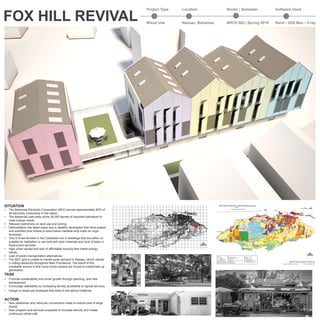
- 1. SITUATION • The Bahamas Electricity Corporation (BEC) serves approximately 85% of all electricity consumers in the nation. • The Bahamas uses daily some 26,000 barrels of imported petroleum to meet energy needs. • Relaxed restrictions on land use and zoning • Deforestation has taken place due to wealthy developers that have erased and scarified pine forests to erect banal roadside strip malls on virgin territories. • One in three families in the Caribbean live in dwellings that are either un suitable for habitation or are built with poor materials and lack of basic in frastructure services. • High urban sprawl and lack of affordable housing that meets energy needs. • Lack of public transportation alternatives. • The BEC grid is unable to handle peak demand in Nassau, which results in rolling blackouts throughout New Providence. The result of this unreliable service is that many home owners are forced to install back up generators. TASK • Promote sustainability and smart growth through planning. and new development • Encourage walkability by increasing density accesibilty to typical services. • Design a mixed-use prototype that adds to the above initiatives. ACTION • New pedestrian and vehicular connections made to reduce size of large blocks • New program and services proposed to increase density and create continuous street wall. Lake Killarney Millars Sound Lake Cunningham Bone Fish Pond Corry Sound Harold Wilson Pond Big Pond Malcolm Creek Legend Coastline Water Bodies Low Density (R1) Low/Medium Density (R2) Medium Density (R3) Medium/High Density (R4) High Density Residential (R5) Commercial - General (C1) Commercial- Tourist (C2) City of Nassau Revitalization (C3) Agriculture (AG) Airport Zone (AZ) Institutional - Public, Semi-Public, Community (INSTIT) Heritage Site (HS) Commercial/Industrial (M1) Industrial- Light (M2) Industrial - Heavy (M3) Forest (F) Conservation Forest (CF) Forest Reserve (FR) Restricted Development/ Mangroves (MG) National Park (NATL PARK) Public Parks/Green Spaces (PPGS) Vector Data Sets Provided by the Department of Lands & Surveys, Department of Physical Planning and The BNGIS Centre Prepared by: Ministry of The Environment Printed: 17th September 2010 FIRST ORDER ZONING MAP OF NEW PROVIDENCE, BAHAMAS 0 4 82 Miles 1:75,000 1 inch equals 1.183712 miles GLADSTONERD BLUEHILLRD EASTST C O W P E N R D W ESTERN RD o LPIA C A R M I C H E A L RD JOE FARRINGTON RD PRINCE CHARLES DR BERNARD RD WULFF RD SHIRLEY ST BAY ST ADELAIDE RD Project Type Location Studio | Semester Software Used Mixed Use Nassau, Bahamas ARCH 502 | Spring 2016 Revit • 3DS Max • V-ray FOX HILL REVIVAL
- 2. EXISTING EXISTING STREETS PROPOSED PEDESTRIAN + VEHICULAR CONNECTIONS PROPOSED PROGRAM MIXED USE RESIDENTIAL CLINIC GROCERY STORE LIBRARY HOMELESS SHELTER A LAND FOR ARCHITECURE FOREST TO BE PRESERVED OPEN SPACE + PEDESTRIAN PATHS LEGEND NEW STREETS SITE MASTER PLAN
- 3. STEP 1 STEP 2 STEP 3 STEP 6 STEP 7 Duplex Retail 2-Bedrm Apt. Mechanical Fitness Center Laundry Lobby LEGEND 1. Louvered Shutters - redirect north east and sout east trade winds through building for cross ventilation. 2. Sun from the south powers photovoltaic panels and heats water. 3. Cisterns store rain water for reuse. 4. Cespit stores sewage until maximum capacity is exceeded. 5. Reinforeced concrete one-way slab construction. (6” floor slabs) 6. 2x12 glulam rafters form gables. 7. Wooden shakes 8. Skylight allow indirect daylight from the north. STEP 5 STEP 8 STEP 9 STEP 4 21 3 768 5 4
- 4. LEVEL 1 SCALE 3/32” = 1’-0” WEST ELEVATION SCALE 3/32” = 1’-0” EAST ELEVATION SCALE 3/32” = 1’-0” LEVEL 2 SCALE 3/32” = 1’-0” LEVEL 3 SCALE: 3/32” = 1’-0” 1. 1. 2. 2. 2. 3. 4. 8.8. 8. 7.7.7. 5. 5. 5. 6.6. 9. 12. 2. 10. 11. 5. 9. 10. 11. 12. 12. 2. 13.13. 14. 9. 10. 11. 12. 12. 2. 13. 9. 10. 11. 12. 12. 2. 13. 15. 10. FOXHILLRD FOX HILL ROUNDABOUT ROSE ST LEGEND 1. VENDOR 2. RETAIL 3. LAUNDRY 4. LOBBY 5. OFFICE 6. PARKING 7. BATHROOM 8. STORAGE 12. 7. 7. 16. 10. 9. 11. 7. 7. 12. 12. 12. 12. 7. 7. 7. 12. 12. 10. 11. 9. 13.13.13. 13. 13. 9. LIVING ROOM 10. DINING ROOM 11. KITCHEN 12. BEDROOM 13. PATIO 14. OPEN SPACE 15. FITNESS ROOM 16. MECHANICAL SITE PLAN SCALE 1/32” = 1’-0”