Discovery of an Accretion Streamer and a Slow Wide-angle Outflow around FUOri...
Peatland monitoring iucn conference v.4
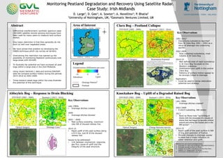
1. Monitoring Peatland Degradation and Recovery Using Satellite Radar.
Case Study: Irish Midlands
Overview Map (Sentinel-1)
• Differential interferometric synthetic aperture radar
(DInSAR) satellite remote sensing techniques have
been used for many years to measure land surface
motion.
• One major restriction is that they generally do not
work so well over vegetated areas.
• We have solved that problem by developing the
ISBAS technique which can survey all terrains.
• Overcoming this restriction has opened up the
possibility of monitoring Peatland continuously over
large areas with DInSAR.
• To illustrate the potential we have surveyed all peat
bogs within a large area in the Irish Midlands
• Using recent Sentinel-1 data and archive ENVISAT
data we compare surface motion during the periods
2015-2016 to 2002-2009.
• Three lowland raised bogs within the area illustrate
the potential of this technique.
D. Large1; D. Gee²; A. Sowter²; A. Novellino²; P. Bhatia2
1University of Nottingham, UK; 2Geomatic Ventures Limited, UK
Key Observations
Clara Bog – Peatland Collapse
1991-20023
• Intensifying subsidence reported3
from W Clara Bog 1991 – 2002 as a
result of drainage into underlying
aquifer.
2002-2009
• Slow sustained subsidence, most
notable in W Clara Bog
2014-15
• Well defined area of rapid subsidence
in W Clara Bog focussed on the
Western soakaway
• Stabilisation and uplift in the central
Clara Bog.
• Patterns of surface motion appear to
be strongly linked to drainage.
Application:
• Could be used to revise restoration
potential and strategy
Abbeyleix Bog – Response to Drain Blocking
Key Observations
Late 1980s
• Drainage ditches created
2009
• Drainage ditches blocked
2002 – 2009
• Peat surface subsiding. maximum
rate SW of disused railway line.
2014-15
• Rapid uplift of the peat surface along
a N-S line, just W of the disused
railway line.
Issues to be addressed:
• Link between mechanical, response,
gas flux, cause of uplift and the
integrity of the peat structure
Knockahaw Bog – Uplift of a Degraded Raised Bog
Key Observations
Late 1980s
• Drainage ditches created4
2002-2009
• S and E subsiding. NW stable
2013
• Bord na Mona note “no infilling of
drains with the exception of a couple of
drains that had begun to become infilled
around and within the flushes and in the
NW section”. 4
2014-15
• Rapid uplift of the peat surface in NW
of bog and upstream of flushes.
• Minimal changes to drainage appear
to have had a major influence on
water retention and uplift.
Legend
Abstract Area of Interest
1
2
References and acknowledgements:
1. Drainage for Clara acknowledges LIFE14NATIE000032.
2. Drainage provide by Bord na Mona
3. Heggler et al 2005, Subsidence of Clara Bog West...
Rapport 121 Wageningen University
4. Knockahaw rehabilitation plan, Bord na Mona