Introduction to Multilingual Retrieval Augmented Generation (RAG)
Background Material
1. RELIABLE, TIMELY, QUALITY, CONSISTENT, PUBLIC DATA
1 What is the Hydrology Project?
The Hydrology Project has been running since 1995 and has led
to a significant change in the availability and reliability of hydro-
meteorological data in India. This should mean that in the
future water resources development projects (such as hydraulic
structure construction, irrigation development through surface
water and/or groundwater) will be based on accurate
information, and thus designed appropriately and economically.
It will also mean that the operation of existing reservoirs, canal
systems and the like can be more efficient as there will be better
knowledge of the likelihood of future inflows, and the actual
operational requirements. Droughts will be more accurately
forecast, and drought management measures will be
better focused.
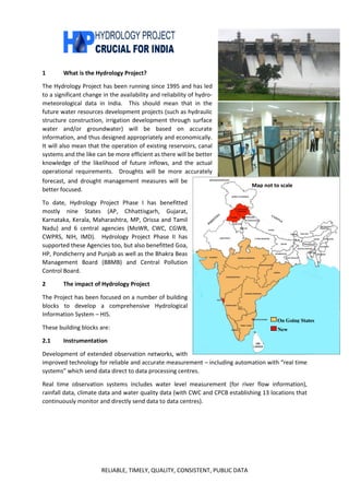
To date, Hydrology Project Phase I has benefitted
mostly nine States (AP, Chhattisgarh, Gujarat,
Karnataka, Kerala, Maharashtra, MP, Orissa and Tamil
Nadu) and 6 central agencies (MoWR, CWC, CGWB,
CWPRS, NIH, IMD). Hydrology Project Phase II has
supported these Agencies too, but also benefitted Goa,
HP, Pondicherry and Punjab as well as the Bhakra Beas
Management Board (BBMB) and Central Pollution
Control Board.
2 The impact of Hydrology Project
The Project has been focused on a number of building
blocks to develop a comprehensive Hydrological
Information System – HIS.
These building blocks are:
2.1 Instrumentation
Development of extended observation networks, with
improved technology for reliable and accurate measurement – including automation with “real time
systems” which send data direct to data processing centres.
Real time observation systems includes water level measurement (for river flow information),
rainfall data, climate data and water quality data (with CWC and CPCB establishing 13 locations that
continuously monitor and directly send data to data centres).
On Going States
New
Map not to scale
2. RELIABLE, TIMELY, QUALITY, CONSISTENT, PUBLIC DATA
2.2 Data Processing
Computer-based systems for reliable and permanent storage of data and detailed data quality
control systems to improve accuracy and reliability. This includes establishment of data centres in
appropriate locations, with computers and specially trained staff, equipped with extensive guidance
manuals and links with central organisations (CWC, CGWB and IMD) for exchange of data and data
validation. Development of centralised, web-based data storage systems for added reliability and
information security (eGEMS for groundwater data, and eSWIS for surface water data).
2.3 Data Use and Application
Development of tools for simpler dissemination of data to users through improved software systems
and fully-computerised records. Development of software systems to make use of data easier - such
as the hydrological design aids (HDA). Development of a system of Hydrological Data User Groups
to improve interaction between data users and the data providers to make sure all requirements are
met appropriately.
3. RELIABLE, TIMELY, QUALITY, CONSISTENT, PUBLIC DATA
2.4 Specific Applications
Under HP II there has been further development of systems to use improved data availability for
specific applications including:
2.4.1 River Basin Planning Tools
Extensive software for data management, catchment modelling and water resources management
modelling to fully understand water resources issues within a river basin. The tools included in
modelling system are surface water planning, groundwater planning, reservoir operation, irrigation
management, drought monitoring and analysis/management, conjunctive use of surface and ground
water and water quality. With the support of consultant the framework is ready and has been setup
for 13 river basins in nine States. The setup basically includes a dashboard to display, analyse, and
allow testing of various scenarios displaying results in both GIS and tabular platforms. Programme
management by the National Institute of Hydrology (NIH).
2.4.2 Flood Management and Reservoir
Operation Support Tools
These tools are used to support operational
decisions required at daily or shorter time
intervals and have been developed for the first
time in India under the project. Such decisions
relate to the scheduling of reservoir releases
and hydropower turbines, the operation of
spillway gates, the issuance of flood warnings,
and the deployment of area evacuation
measures. The tools comprise data
management, catchment modelling and water
resources operation modelling to provide up-
to-the-minute monitoring of water resources /
flood information, together with forecasting
the likely future situation for expected
operational actions. This allows evaluation of
the effect of changing operational decisions to
improve management of floods (such as
system developed for Maharashtra) or
management of reservoirs for maximising operational efficiency (such as system for BBMB).
2.4.3 Purpose-driven Studies
Over 40 studies have been undertaken across the HP II agencies by the agencies themselves
(supported by external consultancies or universities where needed) to showcase the use of
improved hydrological data to improve understanding of water management issues, and provide
advice for resolution of these issues. These studies have included groundwater management, water
quality issues, reservoir sedimentation problems and improved water management to address crop
water needs. Many of the studies have benefitted from the involvement of NIH specialists.
4. RELIABLE, TIMELY, QUALITY, CONSISTENT, PUBLIC DATA
2.4.4 Aquifer Management Pilot Study
The CGWB has undertaken a comprehensive pilot
study in six environments in India to better
understand how to quantify groundwater resources
and facilitate local management of groundwater
through appropriate local knowledge and guidance.
This research and development work is required for
efficient implementation of the programme of work
needed under the 12th
five year plan to develop local
aquifer management plans throughout India.
3 Beyond the Hydrology Project
The revised National Water Policy 2012 stresses the
need for a national level information system for
water resources planning and management by (i) creating a modern water information system with
free exchange of data and by (ii) upgrading the country’s technological ability to collect, process and
disseminate hydrological and environmental data.
While great steps have been taken under the Hydrology Project towards these goals, there is still a
significant way to go to make sure there is sufficient good quality data for the management of India’s
water resources. There are experience and knowledge to be gained from the rest of the world, and
the further development of networks and data quality improvement programmes to improve the
information available to planners and managers of water resources. The value of good data on
water resources for optimising water resources management within the country is so great that the
importance of such further work is hard to over-emphasise.