Enviar pesquisa
Carregar
City farmers
•
Transferir como PPT, PDF
•
0 gostou
•
258 visualizações
Geovation
Seguir
Denunciar
Compartilhar
Denunciar
Compartilhar
1 de 2
Baixar agora
Recomendados
Foodnation
Foodnation
Geovation
CPRE foodmapping
CPRE foodmapping
Geovation
A summary of the Problem Pow Wow facilitated at Sport England
Active liifestyles problem Pow Wow output
Active liifestyles problem Pow Wow output
Geovation
GeoVation Challenge Environment Problem PowWow 2012
GeoVation Challenge Environment Problem PowWow 2012
Geovation
A summary of the process for the GeoVation Environment Challenge - from discovering the problems to idea generation and pitching at GeoVation Camp
How can we help business improve their environmental performance from probl...
How can we help business improve their environmental performance from probl...
Geovation
GeoVation problem Pow Wow Output 23 April 2013, Shoreditch
GeoVation - Digital Shoreditch problem Pow Wow
GeoVation - Digital Shoreditch problem Pow Wow
Geovation
Presentations from the GeoVation event - "Collaboration and User Innovation in Transport" held on 24 September 2012
GeoVation - Collaboration and User Innovation in Transport
GeoVation - Collaboration and User Innovation in Transport
Geovation
Results of the PowWow for Wales Coast Path Challenge - Welsh Language
Wales Coast Path pow wow output final welsh
Wales Coast Path pow wow output final welsh
Geovation
Problems identified at the Wales Coast Path Pow Wow
Wales coast path pow wow output final
Wales coast path pow wow output final
Geovation
Presentation given at The Society for Location Analysis, Winchester, UK 21 February 2012
The power of open data
The power of open data
Geovation
GeoVation How can we transform neightbourhoods in Britain together? Powwow ou...
GeoVation How can we transform neightbourhoods in Britain together? Powwow ou...
Geovation
Foodmapper at ordnance survey
Foodmapper at ordnance survey
Geovation
How can we improve transport in Britain GeoVation camp summary
How can we improve transport in Britain GeoVation camp summary
Geovation
Summary of the output from the problem framing workshop for the GeoVation Challenge 'How can we improve transport in Britain?' held at the London Transport Museum on 19 January 2011.
Final geovation transport pow wow output
Final geovation transport pow wow output
Geovation
Summary of output from GeoVation Powwow held on 19 January 2010 at the London Transport Museum
Final geovation transport pow wow output
Final geovation transport pow wow output
Geovation
A summary of the iScout facilitated support of the GeoVation challenge: ‘How can Britain feed itself?’. November 2010
GeoVation: How can Britain feed itself? camp summary
GeoVation: How can Britain feed itself? camp summary
Geovation
From Problem to Pitch A summary of the iScout facilitated support of the GeoVation Challenge: “How can Britain feed itself?” November 2010
GeoVation: How can Britain feed itself? camp summary
GeoVation: How can Britain feed itself? camp summary
Geovation
Presentation from Sam Henderson, co-founder of Agrarian Renaissance on the need for a radical approach to farming and food and how clever use of geographical information may help address the question: "Can Britain feed itself?" Presented at Ordnance Survey hosted Science and Innovation 2010 Seminar: Underpinning innovation with geography launching this year's GeoVation Challenge - "How can Britain feed itself?"
C:\documents and settings\cparker\desktop\agrarian renaissance
C:\documents and settings\cparker\desktop\agrarian renaissance
Geovation
Presentation from David Simoes-Brown, Strategy Partner at 100%Open on: The Do's and Dont's of Opening Up Data. Seminar summary slide. Presented at Ordnance Survey hosted Science and Innovation 2010 Seminar: Underpinning innovation with geography, launching this year's GeoVation Challenge - "How can Britain feed itself?"
The do's and dont's of opening up data
The do's and dont's of opening up data
Geovation
Presentation from Huw Davies, Warwickshire County Council on the Warwickshire OpenData Project and Hack Warwickshire Competition. Presented at Ordnance Survey hosted Science and Innovation 2010 Seminar: Underpinning innovation with geography launching this year's GeoVation Challenge - "How can Britain feed itself?"
Warwickshire open data project
Warwickshire open data project
Geovation
Presentation from David Simoes-Brown, Strategy Partner at 100%Open, and Chris Parker, Ordnance Survey on open innovation with geographic data. With Seminar summary outcome slide: "Do's and Dont's of opening up data. Presented at Ordnance Survey hosted Science and Innovation 2010 Seminar: Underpinning innovation with geography launching this year's GeoVation Challenge - "How can Britain feed itself?"
Underpinning innovation through geography 16062010
Underpinning innovation through geography 16062010
Geovation
Mais conteúdo relacionado
Mais de Geovation
Problems identified at the Wales Coast Path Pow Wow
Wales coast path pow wow output final
Wales coast path pow wow output final
Geovation
Presentation given at The Society for Location Analysis, Winchester, UK 21 February 2012
The power of open data
The power of open data
Geovation
GeoVation How can we transform neightbourhoods in Britain together? Powwow ou...
GeoVation How can we transform neightbourhoods in Britain together? Powwow ou...
Geovation
Foodmapper at ordnance survey
Foodmapper at ordnance survey
Geovation
How can we improve transport in Britain GeoVation camp summary
How can we improve transport in Britain GeoVation camp summary
Geovation
Summary of the output from the problem framing workshop for the GeoVation Challenge 'How can we improve transport in Britain?' held at the London Transport Museum on 19 January 2011.
Final geovation transport pow wow output
Final geovation transport pow wow output
Geovation
Summary of output from GeoVation Powwow held on 19 January 2010 at the London Transport Museum
Final geovation transport pow wow output
Final geovation transport pow wow output
Geovation
A summary of the iScout facilitated support of the GeoVation challenge: ‘How can Britain feed itself?’. November 2010
GeoVation: How can Britain feed itself? camp summary
GeoVation: How can Britain feed itself? camp summary
Geovation
From Problem to Pitch A summary of the iScout facilitated support of the GeoVation Challenge: “How can Britain feed itself?” November 2010
GeoVation: How can Britain feed itself? camp summary
GeoVation: How can Britain feed itself? camp summary
Geovation
Presentation from Sam Henderson, co-founder of Agrarian Renaissance on the need for a radical approach to farming and food and how clever use of geographical information may help address the question: "Can Britain feed itself?" Presented at Ordnance Survey hosted Science and Innovation 2010 Seminar: Underpinning innovation with geography launching this year's GeoVation Challenge - "How can Britain feed itself?"
C:\documents and settings\cparker\desktop\agrarian renaissance
C:\documents and settings\cparker\desktop\agrarian renaissance
Geovation
Presentation from David Simoes-Brown, Strategy Partner at 100%Open on: The Do's and Dont's of Opening Up Data. Seminar summary slide. Presented at Ordnance Survey hosted Science and Innovation 2010 Seminar: Underpinning innovation with geography, launching this year's GeoVation Challenge - "How can Britain feed itself?"
The do's and dont's of opening up data
The do's and dont's of opening up data
Geovation
Presentation from Huw Davies, Warwickshire County Council on the Warwickshire OpenData Project and Hack Warwickshire Competition. Presented at Ordnance Survey hosted Science and Innovation 2010 Seminar: Underpinning innovation with geography launching this year's GeoVation Challenge - "How can Britain feed itself?"
Warwickshire open data project
Warwickshire open data project
Geovation
Presentation from David Simoes-Brown, Strategy Partner at 100%Open, and Chris Parker, Ordnance Survey on open innovation with geographic data. With Seminar summary outcome slide: "Do's and Dont's of opening up data. Presented at Ordnance Survey hosted Science and Innovation 2010 Seminar: Underpinning innovation with geography launching this year's GeoVation Challenge - "How can Britain feed itself?"
Underpinning innovation through geography 16062010
Underpinning innovation through geography 16062010
Geovation
Mais de Geovation
(13)
Wales coast path pow wow output final
Wales coast path pow wow output final
The power of open data
The power of open data
GeoVation How can we transform neightbourhoods in Britain together? Powwow ou...
GeoVation How can we transform neightbourhoods in Britain together? Powwow ou...
Foodmapper at ordnance survey
Foodmapper at ordnance survey
How can we improve transport in Britain GeoVation camp summary
How can we improve transport in Britain GeoVation camp summary
Final geovation transport pow wow output
Final geovation transport pow wow output
Final geovation transport pow wow output
Final geovation transport pow wow output
GeoVation: How can Britain feed itself? camp summary
GeoVation: How can Britain feed itself? camp summary
GeoVation: How can Britain feed itself? camp summary
GeoVation: How can Britain feed itself? camp summary
C:\documents and settings\cparker\desktop\agrarian renaissance
C:\documents and settings\cparker\desktop\agrarian renaissance
The do's and dont's of opening up data
The do's and dont's of opening up data
Warwickshire open data project
Warwickshire open data project
Underpinning innovation through geography 16062010
Underpinning innovation through geography 16062010
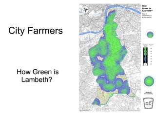
City farmers
1.
City Farmers How
Green is Lambeth?
2.
Incredible Edible Lambeth
City Farmers
Baixar agora