1. The development and use of Collaborative Response Graphics™
(CRG™) in public safety planning and emergency response operations:
By Michael Bruno, Chief of Police, (Ret.)
Copyright 2016 Critical Response Group | All Rights Reserved
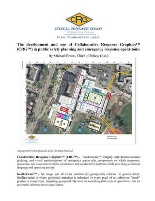
Collaborative Response Graphics™ (CRG™) - GeoRelevant™ imagery with known-distance
gridding, and visual representations of emergency action plan components on which responses,
operations, and assessments can be coordinated and conducted in real time while providing a common
language and operating picture.
GeoRelevant™ - An image and all of its contents are geospatially relevant. In greater detail,
GeoRelevance is where geospatial metadata is imbedded in every pixel of an otherwise "dumb"
graphic or image layer, imparting geospatial relevance on something that, in its original form, had no
geospatial information or significance.
2. 2
CRITICAL RESPONSE GROUP WHITEPAPER
1. Introduction 3-4
2. What exactly are Collaborative Response Graphics ? 5
2.1 Issues and/or problems faced. 6-7
2.2 GXP OpsView™ Solution 7-8
2.3 A Summary of Benefits 8-9
2.4 Law Enforcement/Private Sector Applications 9-10
3. Conclusion 10
4. About Critical Response Group 10
5. About the Author 11
3. 3
CRITICAL RESPONSE GROUP WHITEPAPER
1. Introduction
Law enforcement has a long history of adopting new techniques, tools and tactics to
keep pace with an ever-changing world. Technological advances have made public
safety professionals more efficient, better equipped and have increased their capability
of addressing complex problems in an increasingly complex world.
Critical Response Group Inc. (CRG) is uniquely positioned to pave the way for a
paradigm shift in the way public safety professionals conduct contingency planning,
emergency response and critical infrastructure assessments by providing them with
cutting edge technology and techniques they need in a reliable, expedient manner. CRG
leverages lessons that were learned by the U.S. military’s Special Operation forces by
transforming written emergency operations plans into highly-usable, GeoRelevant
(SMART) visual plans known as Collaborative Response Graphics. The plans are made
available to first responders through GXP OnScene, a secure, web-based application on
their smart phones/devices or computers. The application allows first responders to
visualize their location on the actual plan, and incident commanders can better
coordinate the scene because assets can be tracked in real time (regardless of the agency
or public safety discipline they represent).
Public safety professionals must adapt to the rapidly evolving threats our communities
encounter. That requires our first responders to be quick and efficient at the onset of an
emergency response situation. The complexity of crisis events must be considered,
therefore, some method of simplifying the initial response must be implemented. CRG
operates under the premise that for any emergency operations plan to be useful or real,
two factors must exist: 1) The plan must be accessible to the emergency responders;
and 2) The plan must be understandable. CRG recognizes that organizations take great
care to develop written plans because of policy or statutory requirements, but in most
instances those emergency plans are contained in binders in an office and inaccessible
to first responders when a crisis strikes. To be truly effective, an emergency operations
plan must quickly establish a common operating picture and communication method
because in many instances responders will be unfamiliar with the interior and/or exterior
of a particular facility.
Extensive and time consuming planning processes will soon be a thing of the past.
Collaborative Response Graphics (CRGs) are now providing the ability to share assets,
information, operation plans, logistics and changing conditions of an event across a
variety of platforms. The techniques discussed herein are adaptable and allow the many
4. 4
CRITICAL RESPONSE GROUP WHITEPAPER
different agencies that respond to emergencies to coalesce around what truly is the most
effective method of planning for and responding to emergencies.
The integration of CRGs into the law enforcement planning and emergency response
function will dramatically improve response capabilities and overall efficiency. CRGs
will benefit first responders of all types (police, fire, EMS, OEM, etc.) as well as tactical
units, search and rescue teams and more. The value in the planning process cannot be
overstated. In short, their use will increase the safety of the public as well as the safety
of emergency responders of all types. Their use will greatly benefit risk management
professionals and will also be invaluable to investigators when a critical incident has
occurred.
Critical response Group, Inc. (CRG) was launched with the specific purpose of
establishing a business focused on integrating and implementing the principles of visual
planning and collaborative emergency responses to critical events. The CRG team
consists of Police Chiefs, SWAT team commanders, Fire Chiefs, Emergency
Management Coordinators, Fusion Center Directors and former members of the U.S.
Military Special Operations Command who have served numerous tours in combat.
Working in cooperation with BAE Systems Electronic Systems Inc. and in particular its
Geospatial eXploitation Products™
(GXP®) business unit, our team is implementing the
most contemporary and evolutionary business practices ever designed to ensure
collaboration, shared situational awareness and, most importantly, better critical
incident management.
President Barack Obama, Vice President Joe Biden, and the national-security team monitoring Operation Neptune
Spear (the Osama Bin Laden raid) in real time and referencing Collaborative Response Graphics.
Source: Pete Souza/Official White House photo
5. 5
CRITICAL RESPONSE GROUP WHITEPAPER
2.What Exactly Are Collaborative Response
Graphics™?
Simply put, they are the GeoRelevant products that are created using BAE Systems’
SOCET GXP® software that result from taking images drawn from any number of
sources and “exploiting” the metadata contained therein for a wide variety of uses.
SOCET GXP is a data agnostic software system that is able to exploit data collected by
satellites, aircraft, drones, pictures gleaned from news agency coverage or taken on-
scene with digital cameras or smartphones. Even photographs of relevant persons,
vehicles or structures can be added from the scene in mere seconds.
These images are enhanced by overlaying a GeoRelevant coordinate gridding system
that divides an image of an area or building into easily identifiable sections (Lettered
horizontally and numbered vertically). This allows users to quickly pinpoint specific
locations on that image, even if they have no prior knowledge of the building or area.
This grid system creates a common operating picture, or language, that facilitates
communication across all disciplines.
Using BAE Systems’ SOCET GXP software, Critical Response Group analysts
precisely integrate scale floor plans into the product. This means the floor plans are
“registered” on top of the imagery and the geospatial metadata from the base layer seeps
through the layers of imagery making them GeoRelevant. Additional overlays, or
features, are incorporated into the image and may include the labeling of street names,
buildings and parking lots, hallways or stairways (Numbered and/or color-coded),
critical features (e.g. locations of gas line shutoffs, the nurse’s office, or gymnasiums)
and even specific terrain information. Locations of emergency action plan components
and equipment required by OSHA Part 1910 standards can also be rendered within the
imagery. In addition to identifying Critical features, the CRGs also use the Incident
Command System and the National Incident Management System labeling conventions
to convert the written Emergency Action Plan into a visual format. This technique
allows first responders of all disciplines to understand and act on the Emergency Plan
in seconds. The intent of the CRG is not to replace the written plan but to enhance the
plan by enabling it be understood by all parties in seconds.
Aside from the obvious benefits to schools, places of worship and private buildings
when planning for emergency responses, CRGs are ideal for preplanning major events
including concerts, parades, sporting events and other large or small scale gatherings.
When used in conducting field searches for missing persons, suspects or evidence,
CRGs take large unfamiliar areas and allow responders to navigate them easily while
also tracking personnel movements and communicating location.
6. 6
CRITICAL RESPONSE GROUP WHITEPAPER
2.1. Issues and/or Problems Faced
In today’s world, critical incidents require law enforcement to deploy a variety of
resources when responding to assist. Consider the examples of an active shooter in a
school or the search of a large area for a missing person or fleeing suspect. These events
will probably require the response of multiple agencies including police, fire, EMS,
mutual aid agencies and perhaps local, county, state and federal assets may also be
needed.
Issue 1: Responders being unfamiliar with the location: It is unrealistic to think that
all of the people responding to a particular scene to provide assistance will have
sufficient familiarity of the buildings, streets, residences, fields, etc. Therefore,
consideration must be given to decide what should be the best means to bridge this gap
in knowledge. Consider the large facilities and buildings (malls, hospitals, colleges,
office complexes, schools, etc…) in your jurisdiction and the challenge they present to
first responders. Even local emergency responders may not be intimately familiar with
the layout of the facility, much less mutual aid responders who have never been at that
location. This presents a critical gap for a timely and effective response to a crisis event
Issue 2: Communication: Interoperable communication has been a problem with
which public safety personnel continue to grapple. More than 15 years after 9/11,
implementing systems that allow for true interoperable communication remains a
challenge. Even when the technical interface issue is resolved, first responders are
unable to actually communicate because they are not oriented on a common operating
picture for reference (they are not on the same page). Consequently, this inhibits true
communication because although first responders may be able to talk, they are
essentially speaking different languages. In other words, first responders must quickly,
(and literally) get on the same page in order to truly communicate. As an example, with
today’s commonly used planning and response methods, people with direct knowledge
of a particular school might transmit information about an incident in a school by saying
“….they’re in the Guidance Office”. The problem is that “Guidance Office” is a
meaningless descriptor for someone with no knowledge of the building’s layout.
However using a CRG, responders will immediately be oriented to their surroundings
and will be able to identify, locate and respond to any part of a building with ease and
expediency because they will have a common frame of reference between all
communicating parties. Regardless of your profession or knowledge of a building, when
told that the problem is in grid square H5 or at the intersection of the red and green
hallways, you know where to go.
7. 7
CRITICAL RESPONSE GROUP WHITEPAPER
Issue 3: Impractical Emergency Plans: Most written emergency plans are
cumbersome and impractical. They are often volumes of written information kept in
binders, in a few specific locations, and are often inaccessible or obsolete. Even if the
information is accessible, it often cannot be distributed to critical personnel in a timely
manner. CRGs reduce an entire plan into an easily accessed, single-page, GeoRelevant
graphic that can be quickly accessed and distributed to every first responder.
Issue 4: Command and Control: Anyone who has ever managed a crime scene, major
storm, hazardous situation or other significant event realizes the difficulty of
maintaining continuity of the scene and keeping resources properly aligned. Typically,
those first critical moments are spent orienting people to the scene and dealing with a
variety of unplanned variables (i.e. people self-deploying to a scene).
Can you honestly say you currently have the ability to manage a scene involving
numerous first responders from different agencies (who handle a variety of different
functions and responsibilities) as they converge on a single location in your jurisdiction?
Do you currently have the ability to immediately provide all those responders with
copies of the emergency plan relevant to their responsibilities, a full set of blueprints
for the building and surrounding area and are you able to track their movements to
ensure proper coverage of a scene, perimeter or search area?
The Solution: The introduction of CRGs into your emergency plans and scene
management will eliminate most of these issues resulting in a far more efficient overall
response, more concise planning capabilities and an increase in the safety of all
involved. It will allow first responders to quickly take control of a scene and for incident
commanders to manage an event over extended periods of time. Simplifying the early
stages of an event through the use of a CRG will allow public safety professionals to
tend to more pressing issues.
2.2. GXP OpsView™ Solution
GXP OpsView is the “cloud-based” server that securely stores the CRGs for reference
when needed. Separate folders can be used to differentiate between different groups,
jurisdictions or agencies so each group can provide access as needed to anyone
responding to or involved with a particular incident or event. It can limit or eliminate
anyone’s ability to view files that they are not appropriately cleared to access.
GXP OnScene is a mobile application that can be downloaded onto any Android or iOS
smartphone/tablet at no cost and provides on the go access to authenticated users. In
addition to enabling real-time access of the CRGs, the application also allows for
authenticated users to display their location to other first responders participating in the
incident.
8. 8
CRITICAL RESPONSE GROUP WHITEPAPER
Most smart phones today have a GPS chip that uses satellite data along with Wi-Fi and
cellular signal strength to calculate your location. The GXP OnScene mobile application
uses that location information to enable a responder to be tracked (when they want to
be) as he/she moves about on a scene or as they are enroute to an incident. The
application can also be used to document their movements during an incident which can
be an invaluable tool when conducting field searches and other missions where an
analysis of the terrain that was covered is relevant. This feature can also be helpful in
establishing “safe zones” when dealing with hazardous materials, explosives and other
dangerous items or situations. A known safe distance from a particular substance or
hazardous material can be placed on the CRG and transmitted to responders within
minutes, allowing them to establish perimeters to keep people safe. Finally, this feature
allows a responder with the GXP OnScene mobile app to upload GeoRelevant photos
and videos from the field immediately to their Commander’s digital map.
2.3. A Summary of the Benefits
A. Emergency plans become instantly accessible, living documents that are capable
of being changed “on the fly” and instantly disseminated to responders across all
specialties. Hundreds of pages can be reduced to a single, easily understood and
GeoRelevant plan.
B. CRGs eliminate confusion and provide everyone involved in a particular event
or incident with immediate situational awareness and access to the information
that is relevant to their response. Emergency plans, evacuation routes, staging
areas and assignment positions are instantly available.
C. Using BAEs GXP OpsView, command personnel have the ability to visualize the
location of all key first responders logged into the free and secure smart device
application GXP OnScene and instantly communicate in a common language,
changes in plans, critical safety updates and adjust resources with pinpoint
accuracy.
D. Every CRG is completely customized to the building, facility or location for
which it was developed, and with the use of BAE Systems’ GXP OpsView the
specific characteristics of that location become immediately available to an
emergency responder having access to that information in the field via the free
iOS or Android app.
E. First responders from other agencies or jurisdictions arriving at a scene can be
quickly added to an organization’s server (for free) which gives them access to
9. 9
CRITICAL RESPONSE GROUP WHITEPAPER
critical planning elements that an incident commander needs disseminated. This
minimizes wasted time and allows them to begin dealing with any given situation
more quickly and efficiently.
F. This business practice has been fully vetted and adopted by our nation’s most
elite military/intelligence planners and tacticians. Not a single operation is even
contemplated by those forces which is not planned, coordinated in real time, and
later assessed with this methodology.
G. The costs associated with implementing this simple but critical shift in the way
public safety planning and critical incident coordination is conducted is
inexpensive. In fact, it is so inexpensive that continuing to plan for and conduct
responses to emergencies in a manner that is inconsistent with the lessons our
country has learned and implemented at the highest level, creates a liability for
those tasked with these responsibilities.
2.4. Law Enforcement/Private Sector Applications
A. Law Enforcement: Emergency action plans, critical infrastructure protection,
SWAT operations, crime scene processing, mutual aid responses, executive
protection and aviation support.
B. Prosecutors & District Attorneys: Courtroom presentations, storyboards and
enhanced crime scene documentation.
C. OEM: Disaster planning, response & recovery, flood evacuation coordination
and prioritization and interoperability among a variety of agencies.
D. Fire/Rescue: Emergency action plans, safety perimeter establishment, wildfire
risk assessment, dive team support and search & rescue operations. Hydrant
locations, GPS information, gas shutoff, electrical panel location, location of
hazardous materials. All available real time to firefighters on the same hand held
smart devices they use in their daily chores.
E. Private sector: Emergency plan creation and training, GPS routing, map-based
collaboration, custom mapping, executive protection, building management,
maintenance documentation and much more.
F. Emergency Planning Enhancement: Real time access and understanding to the
critical elements of emergency plans for local schools, hospitals, houses of
10. 10
CRITICAL RESPONSE GROUP WHITEPAPER
worship, critical infrastructures or any other location. The time saved planning
for and coordinating responses to critical incidents has and will continue to save
lives.
3. Conclusion
The United States Military Special Operations and Intelligence Communities have
relied on the use of visual planning technology to improve and enhance its planning
processes and coordinate the execution of critical tasks throughout the war on terror. It
is the standard platform for a wide range of sensitive tasks from drafting plans for
routine operations to the most complex tasks of deploying munitions and planning high-
risk, high-profile raids and attacks on strategic targets.
Law enforcement and all emergency services have been seeking solutions to the myriad
of problems that come with emergency planning, multi-jurisdictional mutual aid
response and working across the many layers of response involved with critical
incidents. Implementing the use of CRGs is a single solution that resolves most of those
issues and it will revolutionize the way public safety professionals plan, respond and
share information.
4. About Critical Response Group, Inc.
Formed in 2016 and formerly the Geospatial Intelligence Division of The Rodgers
Group, LLC, Critical Response Group is a team of dedicated, experienced and proven
professionals from the U.S. Military Special Operations and domestic public safety
communities. Our team members are tenacious problem solvers and tireless advocates
for leveraging best practices and cutting edge technology to protect the public and
critical infrastructure.
Members of our team have served as Police Chiefs, SWAT team commanders, Fire
Chiefs, Emergency Management Coordinators, Fusion Center Directors and former
members U.S. Military Special Operations Command who have served on numerous
tours in combat.
They have a proven record of success operating in environments ranging from the war
on terror overseas to man-made and natural disasters here at home.
To learn more about our company and the services we offer, please visit our website at
www.CRGplans.com or email us at - Info@CRGplans.com
11. 11
CRITICAL RESPONSE GROUP WHITEPAPER
5. About the Author
Chief Michael Bruno retired as Chief of Police in Tenafly, New Jersey after 28 years
of service with 11 years as Chief. His focus throughout his career was on improving the
training of police officers. He holds more than a dozen separate instructor certifications
and has been a featured instructor in a number of events including the statewide Police
Conference in Atlantic City, NJ, instructing active shooter and terrorism response.
He is a graduate of the NJSACOP West Point Command and Leadership Program, the
FBI Law Enforcement Executive Development Program at Princeton University and is
an FBI-certified Crisis Negotiator. He holds ICS Certifications I-100, 200 & 300 from
the N.J. State Police, IS 700 NIMS and IS 800 National Response Framework
certifications through FEMA. He is the recipient of the US Department of Justice/FBI
Investigative Award, the Chiefs Achievement Award and multiple Honorable,
Meritorious Service and Lifesaving Awards.
While Chief, he served as Chairman of the Bergen County New Jersey Police Chiefs
Association SWAT Committee and authored the SWAT team standards that still apply
to all tactical teams in the county. He was appointed by the County Prosecutor as
Chairman of the SWAT Regionalization and Specialized Services Committee which
was tasked with regionalizing and streamlining all tactical teams in the county. The
committee was instrumental in forming the Bergen County Regional SWAT team that
is responsible for handling SWAT calls for a county with over one million residents.
Upon his retirement he was appointed and still serves as the Executive Director of the
largest suburban food pantry in Essex County, providing food, clothing and other
services for people in need.
To contact Chief Bruno, please email him at - MBruno@CRGplans.com