Field Activity Planner - A cloud based digital energy platform

Field Activity Planner offers a cloud based digital platform for enabling rapid visual workflows for your offshore engineering work. The platform allows you to easily integrate with other backend systems and offshore engineering software already in use in your organization either for field design, field planning, or activity scheduling to name a few key areas. If you are looking at different offshore software solutions to improve your day to day activities we use modern browser and cloud technology to deliver a state of the art collaborative field planning software platform that excels in easy to use 2D and 3D field layout and design of your subsea and topside projects. By using a real-time database, we ensure that you can collaborate on field design and planning with your colleagues around the globe to save both time and money by avoiding multiple revisions of proposed layouts. We also support the most common data sources, and formats used for typical offshore software solutions e.g. bathymetry, reservoir, and well paths. Using our SaaS software, you can direct from your browser quickly design a field layout where you load up your bathymetry and/or survey data. Then simply add 3D reservoir and well data for a complete overview and start to finalize you subsea layout by placing generic or company specific subsea and topside assets in the correct locations. And while you design, modify, and collaborate on possible field layouts you will see that cost calculations are constantly updated when the design changes. All this data is securely uploaded and processed in our cloud service and is viewable in both 2D and 3D, and you can invite coworkers into you project, and directly create a shareable URL for view only purposes that can be sent outside your organization to prospective clients and partners.

Recomendados
Recomendados
Mais conteúdo relacionado
Mais procurados
Mais procurados (20)
Semelhante a Field Activity Planner - A cloud based digital energy platform
Semelhante a Field Activity Planner - A cloud based digital energy platform (20)
Último
Último (20)
Field Activity Planner - A cloud based digital energy platform
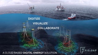
- 1. DIGITIZE VISUALIZE COLLABORATE A CLOUD BASED DIGITAL ENERGY SOLUTION
- 3. FIELD PLANNING REVISIONS APPROVAL SUPPLIERS OPERATORS TODAY’S CONVENTIONAL FIELD PLANNING
- 4. APPROVAL DOMAIN EXPERT PROJECT OWNER EXPEDITED COLLABORATIVE DIGITAL FIELD PLANNING DEVELOPMENT REVIEW & REFINEMENT
- 5. SPECIALISTS INDUSTRY EVERYBODY CREATING IMMEDIATE UNDERSTANDING FOR EVERYBODY WITH VISUALIZATION
- 6. REAL-TIME TEAM COLLABORATION MARINE OPERATOR PLATFORM EPC OPERATOR PARTNERS SPS EPC
- 7. ENSURE ALWAYS UP TO DATE PROJECT DATA ACCESSIBLE FROM ANYWHERE, ANYTIME
- 8. “A DOMAIN EXPERT CAN NOW TAKE THE PROJECT OF THE WAY” Industry expert 90%
- 10. REDUCED TIME TO MARKET Faster design process More efficient design iterations SUBSTANTIALLY REDUCING COST in the design process for the whole value chain by finding the best solution in the design phase STRENGTHENED RISK MANAGEMENT Improving the quality of coordination Securing zero accidents tolerance IMPROVED OPERABILITY Enabling digital working environment Instant global collaboration Cloud based and secure access
- 11. STANDARDIZATION COLLABORATION COSTING DIGITAL OIL SIMPLIFICATION CLOUD TECHNOLOGY REAL TIME DATA API CONTEXTUAL DASHBOARD IoT SENSORS
- 12. LIFE CYCLE PERSPECTIVE Field and Well Planning Equipment design and selection Installation, completion & Intervention Operation P & A - Optimise your field layout - Predict installation types & costs - Schedule P&As according to risk picture - Decommissioning plan - Familiarization - Training - Forecast planned activities - Avoid unplanned interventions/ downtime - Minimize planned downtime - Benchmark your installation success rate - Optimise installation, modifications, intervention and maintenance - Connecting information - Activity tracking and measuring - Control - Benchmark to select the best equipment for your environment - Fabrication; plan logistics and locations
- 13. SOFTWARE as a SERVICE (SaaS) RUNS IN YOUR BROWSER MULTI TENANT OR SINGLE TENANT 24/7/365 AVAILABILITY SECURE, SCALEABLE & RELIABLE OPEN ARCHITECTURE / POWERFUL REST API
- 14. CONTINUOUS DELIVERY OF NEW FEATURES
- 15. BUILD YOUR FIELD
- 16. DRAG AND DROP
- 19. CREATE PRIVATE ASSET LIBRARIES FROM YOUR 3D CAD MODELS
- 21. DATA DRIVEN DESIGN Use Meta-Data to build or link your own data model to your private Asset Library or use the Generic library for equipment and costing options while designing the field. ATTRIBUTES Wide range of data types, units, and input options for user selection on assets, connectors and connections. REST API Populate, update, edit or delete the assigned attributes programmatically with your own data from your backend system to integrate with your workflow. META DATA EDITOR Easy to use UI allows you to define your various equipment configurations and options and link them to your VendorID, cost specifications etc.
- 25. INSTANT COST ESTIMATES Changes in the field layout are immediately visible in the cost module, allowing for interactive analysis. IMPORT/EXPORT DATA TO ANY FORMAT Export cost and Bill Of Materials to MS Excel from the cost module with the click of a button. Or use the API direct with Excel macros. COST SERVER INTERFACE Interface with your own back-end on premise cost/calculation software for instant and accurate up to date cost calculations. COST TABS & CATEGORIES Separate Tabs for Cost Equipment & Operations. Costs are automatically grouped into categories; SPS, SPP, PIPING & INFRASTRUCTURE, etc.
- 31. VISUAL TIMELINE WITH GANTT Once your field is complete, start organizing the installation and other field activities. Bring your GANNT chart to life for immediate understanding by your entire project team.
- 33. PROJECT PLANNING Full planning functionality with status, activity groups and dependencies. Import or Export MS Project files directly.
- 34. FIELD PLANNING Plan installation, drilling, intervention, surveying, pipelaying, tie-ins and all other activities in your field. ASSIGN ACTIVITIES TO ASSETS Keep track of your resources and optimize the sequence of operations. ANIMATE THE FIELD COMING TO LIFE Bring your GANNT plan to life visually. Let all stakeholders see the equipment being installed and connected and keep track of all your vessel locations. Play back the entire timeline day by day. MARINE OPERATIONS Create ports and assign your available vessels to them for mobilization and other port bound activities.
- 37. LOAD YOUR BATHYMETRY OR SURVEY DATA
- 38. USE GENERIC OR YOUR OWN SUBSEA EQUIPMENT
- 39. PLACE YOUR TOPSIDE RIGS & VESSELS
- 40. ADD YOUR 3D RESERVOIR DATA
- 41. AND YOUR WELL PATHS
- 42. INTEGRATE WITH SENSOR / IoT DATA
- 43. SEE YOUR ACTUAL FIELD REPRESENTATION
- 44. SHARE PROJECT Use Field Activity Planner to easily share and discuss your field layout or marine operation plans with your customers/partners by sending a link. REAL TIME MODIFICATIONS When the user clicks on the link they will see the 2D layout view, and you can then make changes or navigate through the project and your recipient will see changes in real time.
- 47. Application Programming Interface REST API Integrate with your own backend software systems and/or services Programmatically Add/Edit/Update Attributes, Metadata allowing easy equipment specification and configuration of all assets Populate or retrieve cost values direct from MS Excel or your own on premise backend costing software such as SAP
- 48. INTEGRATE SIMULATION SERVICES BPT Hydraulics Direct API Integration with Field Activity Planner Adds well fluid properties to well head and template objects automatically BPT-MWF processes these well fluid data inside Petro-SIM to produce a realistic reservoir fluid. Enables quick conceptual Well Fluid Phase Analysis for your various field layout options
- 49. EMBEDDED VISUAL CONTEXT DASHBOARDS See your dashboards linked to your field layout
- 51. Extract 3D geometry from FieldAP to generate high quality rendering of field layouts, or as a starting point for your Engineering CAD work.
- 53. WebVR SUPPORT View your projects directly in immersive 3D VR without any additional processing steps. Interact with the equipment using the controllers. Easily plan ROV operations etc. HTC VIVE SUPPORTED
- 56. WIND POWER ASSET LIBRARY
- 57. Plan Offshore Wind Energy Field Development
- 58. Arnljot Skogvang, Lundin Norway Joakim Bremnes Øian, Senior Manager at Aker Solutions ASA.
- 60. Olav Sylthe olav@fieldap.com +47 484 00 464 Jostein Lien jostein@fieldap.com +47 480 90 903 Darrell Knight darrell@fieldap.com +1 (800) 720-0826 +1 (713) 512-4240 Martin Sorensen martin@fieldap.com +47 91 36 90 43 Pål Roppen paal@fieldap.com +47 90 12 80 05 Oslo Office Houston Office Thornton Brewer thorton@fieldap.com +1 (800) 720-0826 +1 (713) 512-4240