HMCS Vancouver Pre-Deployment Brief - May 2024 (Web Version).pptx
Siddarth Luxembourg city site and situation
1. 16.12.16
Luxembourg City Report
Luxembourg City is the capital of the smallEuropean nation of Luxembourg. A
center for bankers and investors, Luxembourg City is home to people from all
around the world. But it was settled as a fortress, builtas a strategic outpost
for defence and offence, populated by knights and kings.
Here is a reporton the site and situation of the city.
Section A: The Site
Basic Facts:
‘’Luxembourg, alsoknown as Luxembourg City, is the capital city of the Grand
Duchy of Luxembourg and its most populous
commune.’’
Luxembourg City is located atop a rocky
sandstonepromontory overlooking thevalley of
the Alzette River. In ancient times, it had had a
Roman outpostatop it. After purchasing it from
some monks, CountSiegfried of the Ardennes
turned the site into a formidable fortress. Itwas
built and chosen as a settlement by Siegfried for
its sheer defensivemight, as it was atop a high
valley with a sheer drop to its cliffs, with the
drop being 70 m in height.
Being a fortress town with defence as its
priority, the city is built at different levels to
make it harder for enemies to climb it to
attack. The city has a mildly oceanic climate with the averagetemperature
being 17°C, with winters not too cold and summers not too hot. Luxembourg
City is approximately 300 mabove sea level. In total, the land area is around
51.46 km².
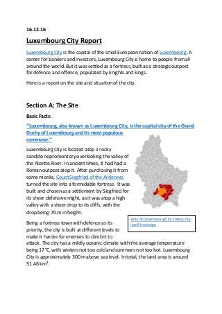
Wiki of LuxembourgCityToday;city
itself inorange
2. SanderusMaps of Luxembourg
City(old)
Site Type:
‘’The city centre occupies apicturesquesiteona
salient, perchedhighonprecipitous cliffs that dropinto
the narrow valleys of the Alzette.’’
The city appears to haveelements of five site types; a
Valley Site, a Gap Town, a Defence Site, a Bridging
Point and a Route ConvergenceSite. The houses and
main fort for the warriors and Counts werearranged
similarly to a Gap Town, however the commoners lived
on the banks of the Alzette, making their homes similar to a Valley Site. The
valley has many bridges built across it as well with settlements on both sides,
making it have elements of a Bridging Point. Its elements of a Route
ConvergenceSite come fromthe fact that it was built at a junction of two
Roman roads, meaning trade and wealth gathering for the knights could be
easier.
Its Defence Site elements are foundinthe fact that it is in the meander of the
River Alzette, atypical feature for a defensive siteas it gave the advantage of
a natural barrier on3 out of 4 sides. As mentionedmany times, the city was
chosen specifically for its defensive capabilities and its arrangement as a
defence site is showninthe map above.
I think that the dominant site type is a mix of Gap Town, as the main
settlement as well as the remains of the fortress of Lucilinburhuc (the fortress
of Siegfried) are locatedatopthe valley insteadof in it and the fact that the
valley is not a part of the site itself, whichpredominantly makes it a Gap
Town as the main city and the fortress bothfit intothe aforementioned
category. It has a river (the Alzette) anda valley nearby to qualify as a Gap
Town and a river meander for a Defense Site, andsince the mainsettlement
is atop a promontory overlooking the valley it thereby becomes a mix of a
Gap Town and a Defense Site.
Access toResources:
‘’The agricultural resourcesof Luxembourg are quite modest’’
The site itself has access to a variety of resources essentialto maintain a
successfulsettlement. Itboasts arable land, meaning that growing crops and
3. feeding animals (cattle, sheep and fowl) would be easy. Crops could flourish at
or around the site, and thus not only could the inhabitants remain fed, the
remaining crops could be sold or traded for valuable resources from other
towns. However, mostof the crops would not be grown in the city itself, but at
the houses towards theedges of it.
The city overlooks thebanks of a river, meaning water for drinking, cleaning or
sewagedraining is easy to fetch and meaning nourishmentand hygiene are
easily taken care of. Paintings suchas the one below TIME PERIOD? alsoshow
that the city had and exploitedgood soil, as large portions of healthy land are
scatteredaroundthe city and some land has clearly beengivenover for
farming by the inhabitants.
The city has a small but sufficient measureof
wood around it, useful for fuel or for buildings,
and the rocky sandstonecliffs of the plateau
could providestone for larger constructs such as
the fortress of Lucilinburhuc itself.
The city is also built on a junction of two
Roman roads, partof a huge network of
roads that spread across Europeand bits
of Africa and Asia, allowing for an immense trading route and meaning
resources thatcould not be obtained on-site could be traded for by passing
traders, soldiers or travellers.
The closest cities onthe roads were Trier and Metz, twomajor cities for both
Frankishand Germanic tribes, meaning that traders andmerchants could
make short journeys tothese major cities tosell goods at the local markets to
people from all over modern France, Belgiumand Germany. Trier in particular
was a powerful city at the time, making it an ideal place to have a connection
withthrough a road.
Benefits for Inhabitants:
Peasants and farmers could thrive with the rich soil for their crops and animals,
artists could be attracted by the promontory’s picturesqueview of the valley
below for their art, travellers and traders for the site’s convenient location
upon a road junction, and mercenaries could come for work in the employ of
the lords and knights.
Wiki of LuxembourgCityinoldendays
4. Section B: The Situation
Soil:
‘’(The) termGutland arises fromthe fertile soil andwarm, dry summers’’
Luxembourg City is part of the Gutland (Good
Country) area, an area known for its fertile and well-
drained land. This gave rise to the many vineyards
that we find surrounding thecity. The fertile soil
would have been of great interest to Siegfried as it
meant that he could grow various crops and animals
for meat to satisfy himself and his men’s appetites.
The site would be excellent for soil as well as cattle,
and the soil’s condition was key to a successfulsettlement.
Metal Deposits andWater:
The area has plentiful iron ore deposits, meaning that if Siegfried had
discovered the metal, he and his men could havefashioned weapons for
themselves without having to use precious resources to purchaseweapons
fromtraders.
The woods around the city (as mentioned before) had fuel for the inhabitants
to cook food and to keep warmand the wood combined from the rock from
the cliff sides could be used to build walls and houses.
The River Alzette that runs through the city can be used for water and if
possiblefishing, so the peasants living in the valley could find someway to
make a living other than justfarming and selling crops to the higher classes.
Defensive Capacity:
‘’Luxembourg took pride in the flattering historical epithet of ‘’Gibraltar of
the North’’ as a result of its allegedimpregnability.’’
Perhaps the most important factor and the sole reason for Siegfried’s choice of
the site is becauseof its defensive strength. Luxembourg, in particular the city,
Wiki of Lucilinburhuc
TrekEarthof part of the Gutland
5. is the ‘’Gibraltar of the North’’, as was declared by many
great powers of the time. Luxembourg City is high atop a
valley, the Pfaffenthal, with a steep climb and a long drop
to it, so access for Siegfried’s enemies would be extremely
tricky, if not impossible. The site has uneven heights,
meaning that enemies would waste their energy climbing
the rises while they wereshot down by archers from the giant fort’s turrets.
The need of bridges to invade the whole fort for enemies was also another
advantage, as the bridges could be destroyed to preventenemies from
crossing, effectively trapping them until they were captured or killed.
Photographs of old maps reveal that Luxembourg alsohad the river as a kind
of moat, and soonly neededheavy walls on one side of the city while all
others were automatically coveredby the river
Alzette, alsomeaning that building resources
would not be wastedon expanding the walls. The
place was excellent defensively and if the natural
strengths didn’tward off or cut down enemies, then
Siegfried’s powerfulfortdid.
Modern Growth:
Defensive Prestige:
Luxembourg City’s famed reputation as a powerfulnaturalfortification made it
a key target for many nations or empires to conquer. As a result, its history up
until 1944 has been one of war and conquering, as nearly all the countries
around it tried to grab Luxembourg for themselves. Luxembourg ended up
being taken over or settled by the Treveri, the Romans, Siegfried, Burgundy,
the Bourbons, theHohenzollerns, the Habsburgs, theFrench, Prussia, the
Netherlands and finally the Nazis. Over the years the fortress was gradually
strengthened until it became an incredibly strong outpostfor whichever
country ruled it at the time. However, in the 19th
century, after French rule
ended, Luxembourg City’s fortifications gradually became less and less
prominent until the Nazis finally put an end to Luxembourg City’s great history
as a fortress town.
Wiki of Oldmap of the city
6. Steel andIron Mining:
‘’Luxembourg owes its wealthtothe presence of a powerful steel industry’’
Shortly after the Nazis weredefeated in WWII,
massivedeposits of iron ore were uncovered in
Luxembourg. Soon, people fromall over Europe
were flocking into the Grand Duchy to mine the
iron and steel fromthe country’s soils. The‘60s
nearly saw an economic decline for
Luxembourg as thousands of people started
to depend on the rapidly fading steel deposits
for a sourcefor economic flow within Luxembourg, and the city, as the capital,
was affected by it most. Soon enough, the world steel market quickly collapsed
due to too much mining and from that point on Luxembourg started to depend
lesser and lesser on its own natural resources.
Banking and Economics:
‘’The country has one of the highest GDP per capita
in the world’’
Now, Luxembourg city is home to people of multiple
cultures who havecome here as expats or
permanent residents to work for numerous
international businesses thathave set up offices
here. The city has grown into a center for bankers,
investors and businessmen and the prosperous
economy that it has come to enjoy comes not from
the benefits of natural resources, butfrom the
constantflow of wealth happening in the city.
Luxembourg is now the world’s second richestcountry and the old forthas
largely been demolished. The country, as well as the city, now gain their
economy fromthe various businessmen who enter and exit the nation.
Limiting Factors:
Travelerguidance blog
of LuxembourgCity
Wiki of Steel Mine inLuxembourg
7. There are indeed very few limiting factors in the situation that could possibly
hinder Luxembourg’s growth, butthere is one prominentfactor that stands out
among them; the country’s (and thecity’s) size.
Luxembourg has always been a small
country, but now, with the constant
flow of people coming in to the
country, it is in danger of
overpopulation. The city’s natural
features such as trees and fields are
slowly being destroyed to build tightly-
packed apartments and offices to
supportthe vastnumber of people entering the country. The Oesling remains
largely untamed and undeveloped, so builders are building more and more on
the Gutland, particularly the city, and now
people moving in are starting to have to live in
tiny establishments crammed in along the city
and the surrounding communes.
The country’s other natural features, sadly
enough, can only be truly seen if one goes out
to the Oesling, which is incredibly ruraland in complete contrastto the
Gutland, a heavily-urbanized economic area.
The capital, Luxembourg City, is now being
covered with buildings and the valley bottom
remains a rural, local area, with no one even
bothering to try building moredown there.
Conclusion
Overall, Luxembourg City has had a complex history. Its uniquesituation led it
to become one of the most prosperous cities in the world. Its natural
fortifications made it a desirable target and the principal reason why Count
Siegfried settled in it years ago. Now, all of that has beenforgotten, but
Luxembourg City continues torise andgrow, withmore and more people
from all over the worldflowing in. All of this was startedby its desirable
geographical strengths, whichyouhave learnedabout through this essay.
Thank you for reading this essay.
Google Maps of Luxembourg Cityasof 2009
Google Maps of Luxembourg Cityas
of 2016