Continental Mapping Projects - USACE Cleveland Levee
•
1 gostou•658 visualizações

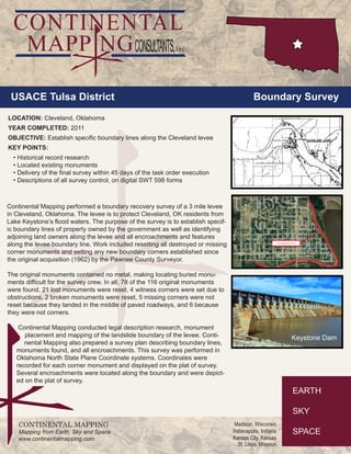
The USACE Tulsa District commissioned a boundary survey of the Cleveland, Oklahoma levee in 2011. Continental Mapping performed the survey to establish the specific boundary lines and identify adjoining landowners. They located existing monuments, reset missing monuments, and delivered the final survey within the required timeframe. The purpose of the survey was to clearly define the property boundaries along the 3 mile levee protecting Cleveland from flood waters of Lake Keystone.
Recomendados

Recomendados
Mais conteúdo relacionado
Mais procurados
Mais procurados (19)
Destaque
Destaque (19)
Semelhante a Continental Mapping Projects - USACE Cleveland Levee
Semelhante a Continental Mapping Projects - USACE Cleveland Levee (6)
Mais de Continental Mapping Consultants
Mais de Continental Mapping Consultants (20)
Último
Último (20)
Continental Mapping Projects - USACE Cleveland Levee
- 1. USACE Tulsa District Boundary Survey LOCATION: Cleveland, Oklahoma YEAR COMPLETED: 2011 OBJECTIVE: Establish specific boundary lines along the Cleveland levee KEY POINTS: • Historical record research • Located existing monuments • Delivery of the final survey within 45 days of the task order execution • Descriptions of all survey control, on digital SWT 598 forms CONTINENTAL MAPPING Mapping from Earth, Sky and Space www.continentalmapping.com Madison, Wisconsin Indianapolis, Indiana Kansas City, Kansas St. Louis, Missouri Continental Mapping performed a boundary recovery survey of a 3 mile levee in Cleveland, Oklahoma. The levee is to protect Cleveland, OK residents from Lake Keystone’s flood waters. The purpose of the survey is to establish specif-ic boundary lines of property owned by the government as well as identifying adjoining land owners along the levee and all encroachments and features along the levee boundary line. Work included resetting all destroyed or missing corner monuments and setting any new boundary corners established since the original acquisition (1962) by the Pawnee County Surveyor. The original monuments contained no metal, making locating buried monu-ments difficult for the survey crew. In all, 78 of the 116 original monuments were found, 21 lost monuments were reset, 4 witness corners were set due to obstructions, 2 broken monuments were reset, 5 missing corners were not reset because they landed in the middle of paved roadways, and 6 because they were not corners. Continental Mapping conducted legal description research, monument placement and mapping of the landslide boundary of the levee. Conti-nental Mapping also prepared a survey plan describing boundary lines, monuments found, and all encroachments. This survey was performed in Oklahoma North State Plane Coordinate systems. Coordinates were recorded for each corner monument and displayed on the plat of survey. Several encroachments were located along the boundary and were depict-ed on the plat of survey.