Eops 2015 2_17
•
0 gostou•541 visualizações

The ocean and air remain warm with sunshine and dry weather across the region. As a result, Puget Sound is a lot warmer going into the new year. Hood Canal is responding with temperatures warmer than previous measurements, breaking its low temperature stint. First signs of growing phytoplankton are coloring the water green. Patches of jellyfish are overwintering in finger inlets of South Sound. Tidal fronts and suspended sediment are visible amidst the stunning San Juan Islands scenery. A sediment-rich water mass is trapped in Rosario Strait. Check out the South Sound Estuarium and the many reasons we love Puget Sound!

Recomendados
Mais conteúdo relacionado
Mais procurados
Mais procurados (19)
Destaque
Semelhante a Eops 2015 2_17
Mais de Christopher Krembs
Mais de Christopher Krembs (8)
Último
Último (20)
Eops 2015 2_17
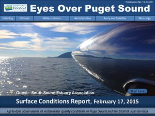
- 1. Surface Conditions Report, February 17, 2015 Eyes Over Puget Sound Fieldlog Climate Water column Aerial photos Ferry andSatellite Moorings Publication No. 15-03-071 Start here Up-to-date observations of visiblewater quality conditions in Puget Sound and the Strait of Juan de Fuca Picture credit: Joe Leatherman Guest: South Sound Estuary Association
- 2. Personalfieldlog p.4 Why do I love Puget Sound? Climateconditions p.6 The air temperatures andoceanconditions remainwarm. Rivers are above normal except at the coast (Chehalis). The past week has generally beensunny and dry across the region. Watercolumn p.7 Puget Sound is a lot warmer at the end of 2014 with new maximumtemperatures observedthroughout the Sound! The higher dissolvedoxygenandcoldtemperature anomalies inHoodCanal are disappearing. Moorings p.37 Comparedto past years,2015 starts withwarmer water and lower salinity at Mukilteo. Dissolvedoxygenis rebounding. Aerialphotography p.10 Patches of jellyfishpersist infinger inlets of SouthSound. First signs of growingphytoplanktonare seenwhere water is turning green. Otherwise,the surface waters are nice shades of blue andgreen and, as expected,carry sediment near rivers. Ferryand satellite p.36 Victoria Clipper is in the shipyard LONG-TERMMARINEMONITORINGUNIT Mya Keyzers Laura Hermanson Joe Leatherman Skip Albertson Dr. Christopher Krembs Guest: Dr. Brandon Sackmann, Integral Julia Bos Suzan Pool Editorial assistance provided by: Suzan Pool, CarolMaloy Marine conditionsfrom 2-17-2015 at a glance Fieldlog Climate Water column Aerial photos Ferry andSatellite Moorings Please give us feedback
- 3. Expanded services and programs A larger location at 309 State Ave. NE hosts classes, citizen science projects, interpretive displays, and larger aquariums. TheEstuarium is more visible this summer; a new muralon the east-facing wall, and new eye-catching artat the entrance. Learn about the fundraising concertfeaturing blues pianist Scott Cossu on May 1st, and other exciting events. South Sound Estuary Association in Olympia Fieldlog Climate Water column Aerial photos Ferry andSatellite Moorings A larger location this summer Visit us on the web at: http://www.sseacenter.org
- 4. I Puget Sound Charismatic marine mammals SunriseOver the Water Islandsand hidden baysWondrousmarinelife Whatdo you love the most aboutPugetSound? Peoplethat arecurious and care Personal Field Impression Fieldlog Weather Water column Aerial photos Ferry andSatellite Moorings Personal Field Impression Fieldlog Climate Water column Aerial photos Ferry andSatellite Moorings
- 5. Sea anemones in orangeand white Unique geological featuresGlacial flour and river plumes Miles of diverse coastline Personal Field Impression Fieldlog Climate Water column Aerial photos Ferry andSatellite Moorings
- 6. Fieldlog Climate Water column Aerial photos Ferry andSatellite Moorings Climateand natural influencesbefore 2-17-2015 Summary: Air temperatures remain above normal, continuing a 10-month trend. Precipitation has been below normal for the past week and month in the Central Puget Sound region. Sunshine has been abundant for the past five days and above normal for the winter. River flows are above normal across the Puget Sound region, but below normal at the coast (Chehalis River). PDO remains in the warm phase, and upwelling is below normal. lowerhigher expected No data New section! Climate and natural influences are conditions that influence our marine waters, including weather, rivers, and the adjacent ocean (previously called Weather). For an explanation of the figure, see: http://www.ecy.wa.gov/programs/eap/mar_wat/weather.html, page 26.
- 7. We use a chartered float plane to access our monthly monitoring stations. We communicate data and environmentalmarine conditions using: 1. MarineWater ConditionIndex (MWCI) 2. EyesOverPuget Sound (EOPS) 3. Anomaliesand sourcedata Fieldlog Weather Water column Aerial photos Ferry andSatellite Moorings Ourlong-termmarinemonitoringstationsinWashington Starthere Isl. .
- 8. Physical conditionstracked in statistically historic context Fieldlog Weather Water column Aerial photos Ferry andSatellite Moorings Nov. 2014: Higher Temperature! LowerOxygenexcept HCLowerSalinity in Central S. Redboxesshow thatthe water measuredinfall 2014 is warmer thanany of our measurements since 1999 Explore profiles atall stations Month In2014,conditions were dominatedby warm water during summer and fall,associatedwiththe NE Pacific Oceanwarmsurface anomaly. InOctober andNovember,temperatures werethe highest onour recordsince 1989. In2014,salinity was higher and later,waters southof Admiralty Reachbecame fresher. Oxygenwas mostly lower except inHoodCanal where a highanomaly persistedinto the fall.
- 9. a) PacificDecadalOscillationIndex(PDO,temperature) (explanation) b) UpwellingIndex(anomalies)(Upwelling,lowoxygen) (explanation) c) NorthPacificGyreOscillationIndex(NPGO,productivity) (explanation) Fieldlog Weather Water column Aerial photos Ferry andSatellite Moorings Theoceanaffectswaterquality: OceanClimateIndices NPGO(x10) PDO/UpwellingIndex Three-year running average of PDO, Upwelling, and NPGO indices scores . -25 -20 -15 -10 -5 0 5 10 15 20 25 -1.5 -1 -0.5 0 0.5 1 1.5 1945 1950 1955 1960 1965 1970 1975 1980 1985 1990 1995 2000 2005 2010 2015 Ocean boundaryconditions are no longer favorable for water qualityin Puget Sound: (a) water is warming (PDO), (b) upwellingoflow oxygen and high nutrient ocean water is again increasing(UpwellingIndex), and (c) higher surface productivityalongthe coast (NPGO) is falling. Where are we headingnext?
- 10. Is the food web changing in Puget Sound? Follow the experts WebEx Hypothesis! Increasesin nitrate concentrations couldbe caused by a top-down controlon phytoplankton biomass. Is Noctiluca a visible harbingerof a food web change? Hypothesis for combining a series of recent observations affecting energy and material transfer to higher trophic levels Arechangesin highertropic levelspart of a story of the low food web?
- 11. Summary: Aerial photography2-17-2015 Patchesof jellyfish persist in finger inlets of South Sound. Firstsigns of growing phytoplankton appear wherewater is turning green. Otherwise, the surfacewaters are in nice shades of blue and green and, as expected, carry sediment near rivers. High tides aremobilizing driftwood. Fieldlog Weather Water column Aerial photos Ferry andSatellite Moorings Start here Mixing andFronts: Tidal frontsand a high tide mobilizing driftwood. Several sizabletidal eddies as a result of strong tides. Debris: Largelines and patches of organic debris in South Sound (Budd and Totten Inlets). Visible blooms: Green-brown: Firstsigns of growing phytoplankton biomass in response to sunny weather across the Sound. No blooms. Jellyfish: Jellyfish patches still persist in southern inlets of South Sound (Totten, Eld, and Budd Inlets). BloomDebrisFront Suspendedsediment: Largesuspended sediment plume confined to region around Rosario Strait. How does this work? Plume Reflections onthe propeller of the plane 1 2 4 5 9 17 Bigsea anemones growingonflotsam Picture credit: Joe Leatherman 1 3 5 6 9 11 12 13 14 15 19 3 20191811 12 1 2 3 5 6 11 12 13 14 15 1918
- 12. Straitof Juan de Fuca San Juan Islands Padilla Bay Main Basin Hood Canal South Sound Whidbey Basin Fieldlog Climate Water column Aerial photos Ferry andSatellite Moorings Observation Maps: Afternoonflight,photos 13-20 Sunny,high visibility,winds Flight Information: Morningflight,photos 1-12 Sunny,cold,high visibility 8 11 10 Aerial photography and navigation guide 6 Centraland NorthSound SouthSound 7 12 5 Flight route and fuelingstop 17 9 18 3 2 1 4 1314 19 16 Tides Feet (Seattle) 4:08 AM 11.65 H 9:38 AM 6.05 L 2:54 PM 11.31 H 9:43 PM -1.56 L 15 20
- 13. Jellyfishpatches and strong organic debris lines. Location: OffBurfoot Park, Budd Inlet (South Sound),9:32 AM. 1 Aerial photography 2-17-2015 Navigate Fieldlog Climate Water column Aerial photos Ferry andSatellite Moorings jellyfish jellyfish Debris Debris
- 14. 2 NavigateAerial photography 2-17-2015 Fieldlog Climate Water column Aerial photos Ferry andSatellite Moorings Numerous jellyfishpatches lasting through the warm winter. Location: Near YoungCove,Budd Inlet (South Sound),9:34 AM. jellyfish jellyfish jellyfishjellyfish jellyfish jellyfish Debris Debris boat
- 15. 3 NavigateAerial photography 2-17-2015 Long organic debris line along front. Location: OffBaron Point,Totten Inlet (South Sound),9:51 AM. Fieldlog Climate Water column Aerial photos Ferry andSatellite Moorings jellyfish Debris boat
- 16. 4 Navigate Fieldlog Climate Water column Aerial photos Ferry andSatellite Moorings Aerial photography 2-17-2015 Skokomish River plume enteringHood Canal between tidally submerged flats. Location: OffUnion (Hood Canal),11:18 AM. suspendedsediment
- 17. 5 NavigateAerial photography 2-17-2015 Fieldlog Climate Water column Aerial photos Ferry andSatellite Moorings Fronts delineating the flow of Skokomish River water. Location: Across from Union,Great Bend (Hood Canal),9:48 AM. Plume Plume Debris boat
- 18. Long front and organic debris line at entrance to Dabob Bay. Location: Across from Seabeck (Hood Canal),10:03 AM. 6 NavigateAerial photography 2-17-2015 Fieldlog Climate Water column Aerial photos Ferry andSatellite Moorings Debris
- 19. Quilcene Bay appears to be clear of algal blooms Location: Dabob Bay(Hood Canal),10:10 AM. 7 NavigateAerial photography 2-17-2015 Fieldlog Climate Water column Aerial photos Ferry andSatellite Moorings
- 20. Tidal eddies form as water flows southward through Portage Canal. Location: Indian Island(North Sound),10:22 AM. 8 NavigateAerial photography 2-17-2015 Fieldlog Climate Water column Aerial photos Ferry andSatellite Moorings tidal eddy tidal eddy boat
- 21. Strong tidal currents (flood) and fine suspended sediments show structures of turbulence and shear. Location: Fort Worden State Park (North Sound),11:04 AM. 9 NavigateAerial photography 2-17-2015 Fieldlog Climate Water column Aerial photos Ferry andSatellite Moorings suspendedsediment boat
- 22. 10 NavigateAerial photography 2-17-2015 Panorama shot of Fort Ebey State Park and Penn Cove. Location: Strait ofJuan de Fuca (North Sound),11:07 AM. Fieldlog Climate Water column Aerial photos Ferry andSatellite Moorings
- 23. 11 NavigateAerial photography 2-17-2015 Strong front with debris line retainingsediment-richsurface water in Rosario Strait. Location: Entrance to Obstruction Pass (San Juan Islands),11:22 AM. Fieldlog Climate Water column Aerial photos Ferry andSatellite Moorings Front suspendedsediment suspendedsediment Debris boat
- 24. Strong front with debris line retainingsediment-richsurface water in Rosario Strait. Location: Entrance to Obstruction Pass (San Juan Islands),11:58 AM. 12 Navigate Fieldlog Climate Water column Aerial photos Ferry andSatellite Moorings Aerial photography 2-17-2015 suspendedsediment Debris Debris
- 25. Strong front with debris line with sediment-richsurface water to the east. Location: Across from San Juan Islands National Wildlife Refuge (San Juan Islands),12:03 PM. 13 NavigateAerial photography 2-17-2015 Fieldlog Climate Water column Aerial photos Ferry andSatellite Moorings Front Front Front suspendedsediment Debris
- 26. A. B. Very structured surface water with fronts and debris lines. Location: A.Eastsound,B.San Juan Islands National Wildlife Refuge (Orcas Island),12:04 PM. 14 Navigate Fieldlog Climate Water column Aerial photos Ferry andSatellite Moorings Aerial photography 2-17-2015 Front Debris Debris
- 27. B. A. 15 Navigate Fieldlog Climate Water column Aerial photos Ferry andSatellite Moorings Front with near-surface phytoplankton-rich layer and debris lines. Location: A.Tumbo Island lookingacross US-Canada border,B.Ship wake (Georgia Basin),12:08 PM. Aerial photography 2-17-2015 Debris Debris Debris ship
- 28. 16 Navigate South Padilla Bay during high tide. Location: North entrance ofSwinomish Channel (North Sound),1:47 PM. Aerial photography 2-17-2015 Fieldlog Climate Water column Aerial photos Ferry andSatellite Moorings
- 29. 17 Navigate Fieldlog Climate Water column Aerial photos Ferry andSatellite Moorings Suspended sediment of the Skagit River carrying woody debris into Skagit Bay. Location: Near La Conner, Skagit Bay (WhidbeyBasin),1:50 PM. Aerial photography 2-17-2015 Plume
- 30. B. D. Plumes of a murky creek (A), turbid and green water (B), patches of organic debris and driftwood (C, D) Location: A-B.Livingston Bay,C-D.Outside Triangle Cove,Port Susan (WhidbeyBasin),2:27 PM. Plume tidal eddy Plume woodydebris woodydebris Debris Debris A. C. 18 Navigate Fieldlog Climate Water column Aerial photos Ferry andSatellite Moorings Aerial photography 2-17-2015
- 31. A. B. C. D. 19 Navigate Fieldlog Climate Water column Aerial photos Ferry andSatellite Moorings Smaller bays prone to water quality issues are appearing relatively clear (A-B, D). Small eddy (C). Location: A-C.Holmes Harbor (WhidbeyBasin),D. Port Gamble (Hood Canal),3:50 PM. Aerial photography 2-17-2015 suspendedsediment suspendedsediment Plume tidal eddy Debris boat boat boat
- 32. 20 Navigate Ongoing suspended sediment from human activity. Location: NortheasternbayofHarstine Island,Case Inlet (South Sound),4:27 PM. Aerial photography 2-17-2015 Fieldlog Climate Water column Aerial photos Ferry andSatellite Moorings suspendedsediment boat boat
- 33. NorthSound/SanJuan Islands Date: 2-17-2015 CentralSound Aerial photography observations in Central SoundQualitative aerial observer map during transit Navigate Fieldlog Climate Water column Aerial photos Ferry andSatellite Moorings 5 6 10 9 11 12 4 7 8 13 15 16 17 14 18 19 Numbers on map refer to picture numbers for spatial reference
- 34. Date: 2-17-2015 Qualitative aerial observer map during transit Numbers on map refer to picture numbers for spatial reference Navigate Fieldlog Climate Water column Aerial photos Ferry andSatellite Moorings SouthSound 1 2 3 20
- 35. Legendto map annotations Comments: Maps are producedby observers during and after flights. They are intendedto give an approximate reconstructionofthe surface conditions onscales that connect to and overlapwithsatellite images inthe sectionthat follows. Debris: Debris canbe distinguished into natural and anthropogenic debris floatingat the surface sensu Moore andAllen(2000). The majority of organic debris inPuget Sound is natural and mixedwithdiscardedman-made pieces of plastic,wood,etc. Fromthe plane,we cannot differentiatethe quality of debris at the surface andtherefore,call it for reasons of practicality just “debris”. S.L. Moore,M. J. Allen. 2000. Distribution of Anthropogenicand Natural Debris on the Mainland Shelf of the Southern California Bight. Marine Pollution Bulletin,40(1): 83–88. Navigate Fieldlog Climate Water column Aerial photos Ferry andSatellite Moorings
- 36. Current Conditions: Victoria Clipper in the shipyard this month. No data. Brandon Sackmann Contact: bsackmann@integral-corp.com Fieldlog Climate Water column Aerial photos Ferry andSatellite Moorings Ferry and satelliteobservations2-17-2015 Starthere 16 November 201416 November 2014 TheVictoria Clipper IV carries sensors in its sea chest. The sensors allow us to get surfacetransects of temperature, chlorophyll, salinity, and other bio-optical measurements between Seattle and Victoria, BC twice per day.
- 37. Mooring observationsand trends 02-04-2015 to 02-17-2015 Fieldlog Climate Water column Aerial photos Ferry andSatellite Moorings AtMukilteo, recent observations indicate continuation of decreasing water temperatureand increasing dissolved oxygen. In the upper mooring, water mixing appears influenced by tides. In early February, the deeper mooring detected decreasing salinity and increasing temperature that coincides with river flows. These plots show the probability of observationsover the pasttwo-week period. High probability shown in warmcolors. Left Panels: Density is defined by salinity and temperature. Right Panel: Dissolved oxygen concentration in relation to salinity. 2-6 m depth Dissolvedoxygennot measured 12-16 m depth
- 38. Mooring observationsand trends 01-18-2015 to 02-17-2015 Fieldlog Climate Water column Aerial photos Ferry andSatellite Moorings Our mooring station in Mukilteo is located in Whidbey Basin near Everett. Itis also located at the transition between Possession and Central Soundsat a depth that is influenced by the Skagitand Snohomish river discharges, prevailing winds, and tidal mixing. Asthe largest regional contributor of freshwater to Puget Sound, understanding the timing and magnitude of the Skagit River flow is important. We present data of daily means for the past 31 days. Data are plotted in Pacific Standard Time. Wind data arefrom Paine Field in Everett. River flow data arefrom USGS. Click on icon to view real-time data of the moorings 2.0 2.5 3.0 3.5 4.0 4.5 DailyTidalRange (db) Near-bottom sensor and associated environmental data at Mukilteo -10 -5 0 5 10 15 20 MeanDailyWind Speed(kts) Northerly Southerly 0 500 1000 1500 2000 18-Jan 19-Jan 20-Jan 21-Jan 22-Jan 23-Jan 24-Jan 25-Jan 26-Jan 27-Jan 28-Jan 29-Jan 30-Jan 31-Jan 1-Feb 2-Feb 3-Feb 4-Feb 5-Feb 6-Feb 7-Feb 8-Feb 9-Feb 10-Feb 11-Feb 12-Feb 13-Feb 14-Feb 15-Feb 16-Feb 17-Feb MeanDailyRiver Discharge(m3/sec) SkagitRiver Snohomish River 27.0 28.0 29.0 30.0 9.6 9.7 9.8 9.9 10.0 10.1 MeanDaily Salinity(psu) MeanDailyWater Temperature(°C) Temperature Salinity
- 39. Mooring observationsand trends Mukilteo2010 to 2015 Fieldlog Climate Water column Aerial photos Ferry andSatellite Moorings Atthe Mukilteo mooring, weuse the near-bottom sensor (12-16 mdeep) to measure significant inter- annualvariability in temperature, salinity, and dissolved oxygen. Inter-annualvariability is shown over a 5-year period. All three variables show strong seasonality. Ascompared to past years, the start of 2015 is showing thatwater temperature is warmer and salinity is lower. Dissolved oxygen is roughly similar to 2010, 2011, and 2013. Seasonally, there is an increase in water temperature, decrease in salinity, and little change in dissolved oxygen. Pleasenote that data are provisional. Data are in GMT.
- 40. Accessmooring data: ftp://www.ecy.wa.gov/ea p/Mooring_Raw/Puget_S ound/ Ferryand satellite : Suzan.Pool@ecy.wa.gov Get data from Ecology’sMarine MonitoringPrograms Long–Term MonitoringNetwork Real–Time SensorNetwork Accesscore monitoringdata: http://www.ecy.wa.gov/a pps/eap/marinewq/mwda taset.asp christopher.krembs@ecy.w a.gov Ecology’s long-termmarine monitoring stations Ferrytrack Fieldlog Climate Water column Aerial photos Ferry andSatellite Moorings Riverand Stream WaterQuality Monitoring http://www.ecy.wa.gov/programs/eap/fw_riv /rv_main.html Discontinued (fundingcuts)
- 41. You maysubscribe or unsubscribe to the Eyes Over Puget Sound email listservby going to: http://listserv.wa.gov/cgi-bin/wa?A0=ECOLOGY-EYES-OVER-PUGET-SOUND Many thanks to our business partners: Clipper Navigations,SwantownMarina,andKenmore Air. We are looking forfeedbackto improve ourproducts. Dr. ChristopherKrembs christopher.krembs@ecy.wa.gov Marine Monitoring Unit EnvironmentalAssessment Program WA Department of Ecology Fieldlog Climate Water column Aerial photos Ferry andSatellite Moorings