Jual Mobile Mapper Spectra MM20 Call Budi 082119953499

PT. Minds Indo Survey Komp/ Ruko Mega Kalimalang Kav.8 Jl. KH Noer Ali No.11 Pekayon, Bekasi Telp : 021-95099644, Fax : 021-88860790 Mobile : 082119953499/ 087886144398, PIN : 237FC845 Email : budi1080@yahoo.com/ budi1080@gmail.com PT. Minds Indo Survey hadir Sebagai Distributor Alat Survey tanah atau bangunan yang mampu memberikan solusi terlengkap untuk memenuhi kebutuhan Pengadaan Alat-alat ukur survey dan Pemetaan beserta accessories pendukungnya, Sekarang ini, kita telah masuk di era globalisasi dalam segala hal termasuk era globalisasi technologi yang mempunyai percepepatan perkembangan dari satu technology ke generasi technology yang lebih muthakir, semua orang bisa saling berhubungan dengan berbagai latar belakang keperluan yang berbeda-beda tentunya harus di dukung oleh Infra strukture Networking menjadi hal baku yang di perlukan Oleh Semua Orang baik itu untuk keperluan Perusahaan ataupun Sebuah Organisasi. Adapun lingkup pekerjaan kami meliputi: Penjualan, Service/Perbaikan dan Rental dengan mnghadirkan merk sebagai berikut : 1. Nikon 2. Spectra 3. Minds 4. Garmin 5. Horizon A.Penjualan ( Sale ): NIKON : I.Nikon Automatic Level : 1. Automatic Level Nikon AC2S 2. Automatic Level Nikon AE7 3. Automatic Level Nikon AS2C II.Digital Theodolite Nikon : 1.Theodolite Nikon NE-100 2. Theodolite Nikon NE-102 III. Total Station Nikon: 1.Total Station Nikon DTM 322 (1 Muka) 2.Total Station Nikon DTM 322 + 3.Total Station Nikon NPL 322 4.Total Station Nikon NPL 322 5.Total Station Nikon Nivo 2 M 6. Total Station Nikon Nivo 3 M Spectra : I. Automatic Level Spectra 1.Automatice Level Spectra AL-20 M 2.Automatice Level Spectra AL-24 M 3.Automatice Level Spectra AL-28 M 4.Automatice Lavel Spectra AL-32 A II. Theodolite Spectra 1.Thedolite Spectra DET-02 III. Total Station Spectra 1.Total Station Spectra Focus 6 (5”) 2.Total Station Spectra Focus 6 (2”) 3.Total Station Spectra Focus 8 (5”) 4.Total Station Spectra Focus 8 (2”) IV. GPS Hand Held ( Mapping ) 1.Mobile Mapper Ashtech MM 20 2. Mobile Mapper Ashtech MM 120 V. GPS Geodetice 1.Promark 120 L1 GPS 2.Promark 120 L1 GPS Glonass 3. Promark 220 RTK L1 L2 4.GPS Geodetic Spectra SP80 GNSS Receiver 5. Promark 700 6. Promark 800 8. Kronos 300 MINDS I. Minds Automatic Level : 1.Minds Automatice Level AT-28 2.Minds Automatice Level AT-32 II.Theodolite Minds 1.Theodolite Minds CDT-02 2.Theodolite Minds DT-02 Absolute 3. Theodolite Minds MDT-2 Laser Pointer Garmin I.GPS Garmin 1.GPS Garmin 78 S 2.GPS Garmin 62 S 3.GPS Garmin Etrex 10 4.GPS Garmin Etrex 30 Catatan : Price List akan dikirim sesuai permintaan

Recomendados
Mais conteúdo relacionado
Mais de Budi anto
Mais de Budi anto (20)
Último
Último (20)
Jual Mobile Mapper Spectra MM20 Call Budi 082119953499
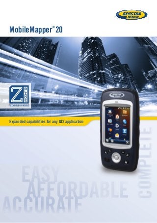
- 1. Expanded capabilities for any GIS application MobileMapper ® 20
- 2. MobileMapper20 MobileMapper 20 Geographical Information Systems and Location Based Services are now being used in a wide range of applications and organizations. The growing need for geo-localization is naturally boosting the demand for efficient and affordable data collection solutions. Spectra Precision is leading the democratization of GNSS, enabling wider access to professional mapping. With MobileMapper 20, Spectra Precision makes it possible to deploy a professional accurate GIS receiver to any field work force. Powerful and complete, MobileMapper 20 is the ideal enabling tool for a huge range of positioning applications. With MobileMapper 20, organizations will improve the quality of their georeferenced information and their field productivity, yielding reduced operational costs. Secure Your Field Work ■■ A wide range of capabilities in a compact, lightweight design ■■ Several days of battery life ■■ Rugged and reliable Unpack and Start Logging ■■ Ready-to-use complete mapping solution for field and office ■■ User friendly Windows® Embedded Handheld 6.5 ■■ Easy-to-use software for short learning curve and quick logging operations Ideal for Data Maintenance or Inspection ■■ Log your assets in real-time with 1 to 2 meter accuracy ■■ Connect field and office work force for maximum productivity ■■ Achieve half meter accuracy with post-processing
- 3. MobileMapper Field and Office Software A complete solution The Spectra Precision MobileMapper software suite includes all the GIS features that professionals really need, without the burden of complicated and rarely used functions. Running on MobileMapper receivers, MobileMapper Field is the perfect solution for GIS data collection, asset management, area measurement, map creation and update. The software is very intuitive and easy-to-use, requiring minimum training. It also provides a direct interface to external sensors for a complete field solution. The Spectra Precision MobileMapper Office tool can be used to differentially post-process raw GPS data collected with the MobileMapper Field software. Through an Internet connection, MobileMapper Office can automatically find and download the base data files that will match the collected raw data; it then computes corrected positions automatically. Tune MobileMapper 20 To Your Applications With Windows Embedded Handheld 6.5 you may upload necessary utilities or software on your MobileMapper 20, to suit your next job. You can collect GIS/GPS points and maps via the GIS application of your choice, either third-party software such as ESRI® ArcPad® or a purpose-built Spectra Precision application.
- 4. GNSS Characteristics ■■ Internal antenna: 20 channels - GPS L1 C/A - SBAS: WAAS/EGNOS/MSAS/GAGAN ■■ External antenna connector ■■ NMEA output Accuracy Specifications (Horizontal RMS)1 ■■ Real-time SBAS: < 2 m typical ■■ Post-processed: < 50 cm typical Processor ■■ ARM9™ ■■ Clock frequency: 600 MHz Operating System ■■ Microsoft® Windows Embedded Handheld 6.5 ■■ Languages available: English, French, German, Italian, Japanese, Korean, Portuguese, Spanish, Simplified Chinese ■■ Software package includes: - Internet Explorer® - Office Mobile - ActiveSync® - Transcriber (handwriting recognition) Communications Cellular ■■ Built in GSM/GPRS/HSPA (3.5G) Modem Versions ■■ P/N 802168-00: 3.5 G: 900/2100 MHz; 2G: 850/900 /1800 MHz ■■ P/N 802168-10: 3.5G: 850/900 MHz; 2G: 850/900/1800/1900 MHz Bluetooth ■■ Bluetooth 2.1 with EDR WiFi ■■ Integrated Interface ■■ USB Physical Characteristics Size ■■ 169x88x25 mm Weight ■■ 380g with battery (310g without) User Interface Keyboard ■■ 4-way navigation, menu, contextual keys ■■ Illuminated keyboard with touch screen ■■ Virtual keyboard Display ■■ VGA Color TFT High resolution display sunlight readable with touch screen, LED backlight. ■■ Size: 3.5” ■■ Colours: 262k Memory ■■ 256 MB SDRAM ■■ Storage: 512 MB NAND Flash (non volatile) ■■ MicroSDHC™ memory card (up to 32GB, SanDisk® , Kingston® recommended) Environmental Characteristics ■■ Operating temperature: -10° to +60°C (14 to 140°F) ■■ Storage temperature: -30° to +70°C without battery (-13 to 158°F) ■■ Humidity: 95% non condensing ■■ Waterproof: IP54 ■■ Free drop: 1.2 m on concrete Power Characteristics ■■ Battery life: > 20 hrs @ 20 ºC with GPS on2 ■■ Charging time: 4 hours ■■ Removable battery Multimedia & Sensors ■■ Camera 5M Pixels ■■ E-Compass ■■ G-Sensor ■■ Speaker ■■ Microphone Software Options ■■ Spectra Precision MobileMapper Field and Office software ■■ Post-processing ■■ ESRI ArcPad software bundle (USA only) Standard Accessories ■■ Stylus ■■ Hand-strap ■■ A/C charger ■■ USB cable Optional Accessories: ■■ External magnetic GPS antenna ■■ Pole bracket 1 Handheld accuracy performance achieved in good conditions (open sky) with PDOP <3 and more than seven satellites in view. 2 GPS on, no Bluetooth or WiFi are used, backlight used 20% of the time at minimal settings. * Including available options. MobileMapper 20 Technical Specifications* SCAN THIS CODE FOR MORE INFORMATION ©2014 Trimble Navigation Limited. All rights reserved. Spectra Precision is a Division of Trimble Navigation Limited. Spectra Precision and the Spectra Precision logo are trademarks of Trimble Navigation Limited or its subsidiaries. All other trademarks are the property of their respective owners. Contact Information: AMERICAS Spectra Precision Division 10368 Westmoor Drive Westminster, CO 80021, USA +1-720-587-4700 Phone 888-477-7516 (Toll Free in USA) EUROPE, MIDDLE EAST AND AFRICA Spectra Precision Division Rue Thomas Edison ZAC de la Fleuriaye 44474 Carquefou (Nantes), France +33 (0)2 28 09 38 00 Phone ASIA-PACIFIC Spectra Precision Division 80 Marine Parade Road #22-06, Parkway Parade Singapore 449269 +65-6348-2212 Phone www.spectraprecision.com