

Recomendados
Mais conteúdo relacionado
Mais procurados
Mais procurados (20)
Semelhante a Earth's interior bs 1st year
Semelhante a Earth's interior bs 1st year (20)
Mais de Awais Bakshy
Mais de Awais Bakshy (19)
Último
Último (20)
Earth's interior bs 1st year
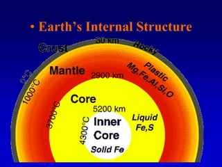
- 1. • Earth’s Internal Structure
- 2. • This drilling ship samples sediment and rock from the deep ocean floor. It can only sample materials well within the upper crust of the earth, however, barely scratching the surface of the earth's interior
- 3. Seismic Waves Are The Key Most of our understanding of the Earth’s interior comes from the detailed study of the behavior of seismic waves within the Earth’s interior. Seismic waves “bounce” off the different layers of the Earth to send a “picture” of the Earth’s interior.
- 4. The Crust – The crust is the thin layer of solid, brittle material that covers the Earth. – There are some differences in the crust depending on where on the surface you are. • The crust under the oceans is known as Oceanic Crust and the crust below the continents is known as Continental Crust. • The crust under the ocean is much thinner than the crust under the continents. • Seismic waves move faster through the oceanic crust than through the continental crust. – The material that makes up the continental crust is called sial • This is due to the fact that it is mostly made up of rocks containing silicon and aluminum. • The oceanic crust is called sima as it is made up mostly of rocks containing silicon and magnesium.
- 5. There is a sharp boundary between the crust and the mantle that is called the Mohorovicic discontinuity or Moho for short. • This is an area of increased velocity of seismic waves as the material is denser in the mantle (due to higher proportion of ferromagnesium materials and the crust is higher in silicates). There are differences in the material that makes up the continental crust and the oceanic crust. • Continental crust is made mostly of less dense (2.7 g/cm3) granite type rock, while the oceanic crust is made of more dense (3.0g/cm3) basaltic rock.
- 6. • Continental crust is less dense, granite-type rock, while the oceanic crust is more dense, basaltic rock. Both types of crust behave as if they were floating on the mantle, which is more dense than either type of crust.
- 7. • The Mantle – The mantle is the middle part of the Earth’s interior. – 2,900 km thick between the crust and the core. – At about 400 and 700 km the pressure and temperature of the mantle increase and change the structure of the olivine minerals found.
- 8. • Seismic wave velocities increase at depths of about 400 km and 700 km (about 250 mi and 430 mi). This finding agrees closely with laboratory studies of changes in the character of mantle materials that would occur at these depths from increases in temperature and pressure.
- 9. – 700 km is the boundary between the upper mantle and the lower mantle. • No earthquakes occur in the lower mantle.
- 10. The Lithospheric Plates The crust and the upper most mantle of the Earth is broken into many pieces called plates. The plates "float" on the soft, semi- rigid part of the mantle known as asthenosphere.
- 11. The Lithosphere The crust and the upper layer of the mantle together make up a zone of rigid, brittle rock called the Lithosphere.
- 12. The Asthenosphere The asthenosphere is the semi-rigid part of the middle mantle that flows like hot asphalt under a heavy weight.
- 13. Mesosphere. The material below the asthenosphere.
- 14. The Core
- 15. The Outer Core The core of the Earth is like a ball of very hot metals. The outer core is so hot that the metals in it are all in the liquid state. The outer core is composed of the melted metals of nickel and iron.
- 16. The Inner Core The inner core of the Earth has temperatures and pressures so great that the metals are squeezed together and are not able to move about like a liquid, but are forced to vibrate in place like a solid.
- 17. • Earth’s Core – An earthquake will send out P-waves over the entire globe, except for an area between 103O and 142O of arc from the earthquake. – This is called the P-wave shadow zone, as no P-waves are received here. – P-waves appear to be refracted by the core, which leaves a shadow.
- 18. • The P-wave shadow zone, caused by refraction of P- waves within the earth's core.
- 19. – There is also an S-wave shadow zone that is larger than the P-wave shadow zone. – S-waves are not recorded in the entire region more than 103O away from the epicenter. – There appear to be 2 parts to the core. • The inner core with a radius of about 1,200 km (750 mi) • The inner core appears to be solid • The outer core has a radius of about 3,470 km (2,160 mi) • The core begins at a depth of about 2,900 km (1,800 mi)
- 20. • The S-wave shadow zone. Since S-waves cannot pass through a liquid, at least part of the core is either a liquid or has some of the same physical properties as a liquid.
- 21. • Isostasy
- 22. • Isostasy is an equilibrium between adjacent blocks of the crust as they float on the upper mantle. – There is an upward buoyant force that is exerted on the crust by the upper mantle. – This is because there is greater pressure upward from the upper mantle than there is downward from the crust.
- 23. • Isostatic adjustment. – The crustal plates sink to a depth where the pressure is greater than the downward pressure and they are buoyed up by this increased pressure. – The crust can be viewed as a tall block with a deep root that extends into the mantle.
- 24. • (A)Isostasy is an equilibrium between the upward buoyant force and the downward force, or weight, of an object in a fluid. (B) The earth's continental crust can be looked upon as blocks of granitelike materials floating on a more dense, liquidlike mantle. The thicker the continental crust, the deeper it extends into the mantle.
- 25. • Earth’s Magnetic Field
- 26. • The Earth’s magnetic field is produced by the slowly moving liquid part of the iron core. • The Earth’s magnetic field circulates around the geographic poles. – It also undergoes occasional flips of polarity, called Magnetic reversal. – The magnetic orientation that we are currently experiencing has persisted for about 700,000 years and is currently about to undergo another reversal. – Since the magnetic field also deflects cosmic rays, solar wind, and charged particles, this reversal could represent a major environmental hazard for all life on the Earth.
- 27. • Formation of magnetic strips on the seafloor. As each new section of seafloor forms at the ridge, iron minerals become magnetized in a direction that depends on the orientation of the earth's field at that time. This makes a permanent record of reversals of the earth's magnetic field.
- 28. • There are several lines of evidence for this reversal of field. – Iron particles found in Roman artifacts show that the Earth;s magnetic field was 40% stronger then than it is now. • At this rate the field strength would be zero in 2,000 years. – Iron minerals that are crystallized on igneous rock, point toward the magnetic poles like compasses. • These give us evidence of the strength and the direction of the magnetic field in the past.
- 29. • The earth's magnetic field. Note that the magnetic north pole and the geographic North Pole are not in the same place. Note also that the magnetic north pole acts as if the south pole of a huge bar magnet were inside the earth. You know that it must be a magnetic south pole, since the north end of a magnetic compass is attracted to it, and opposite poles attract.
- 30. • Magnetite mineral grains align with the earth's magnetic field and are frozen into position as the magma solidifies. This magnetic record shows the earth's magnetic field has reversed itself in the past.
- 32. • Introduction – When one looks at a globe, it is easy to visualize how the continents at one time in the Earth’s history could have been bound together. – North and South America seem to fit into Europe and Africa in a slight s-shaped curve. – Alfred Wegener proposed that the continents were at one time part of a super continent, called Pangaea – Wegener further hypothesized that the continents had moved apart during the history of the Earth by what is called continental drift.
- 33. • (A)Normal position of the continents on a world map. (B) A sketch of South America and Africa, suggesting that they once might have been joined together and subsequently separated by a continental drift.
- 34. – Recall that the crust floats on the more liquid mantle and is buoyed up by its density. – Recall also that the mantle is molten, which gives it great pressure and temperature. – Given these lines of thought, it is not hard to see how the continents, already floating on the magma which is at great pressures, could be forced apart at certain areas where perhaps the crust was weaker or could be forced to break (fault).
- 35. • Evidence from the Ocean – The ocean contains chains of mountains called oceanic ridges. – The ocean also contains long, narrow trenches that always run parallel to the continents, called oceanic trenches.
- 36. – Three kinds of observations started scientists to wonder in the direction that allowed an explanation for Wegener’s continental drift. • All submarine earthquakes that were found and measured were found to occur in a narrow band under the crest of the Mid-Atlantic Ridge • There is a long valley that runs along the crest of the Mid-Atlantic Ridge, called a rift. • There was a large amount of heat escaping from this rift.
- 37. • The Mid- Atlantic Ridge divides the Atlantic Ocean into two nearly equal parts. Where the ridge reaches above sea level, it makes oceanic islands, such as Iceland.
- 38. – It was thought that the rift might be a crack in the Earth’s crust. – This lead to the formation of the Seafloor Spreading hypothesis • Hot, molten rock moved from the interior of the Earth to emerge alone the rift, flowing out in both directions to create new rocks along the rift.
- 39. • The pattern of seafloor ages on both sides of the Mid- Atlantic Ridge reflects seafloor spreading activity. Younger rocks are found closer to the ridge.
- 40. • Lithosphere Plates and Boundaries – Plate tectonics states that the lithosphere is broken into fairly rigid plates that move on the asthenosphere. – Some plates contain part of a continent and part of an ocean basin, while others contain only ocean basins. – Earthquakes, volcanoes, and the most rapid changes in the Earth’s crust occur at these plate boundaries.
- 41. • The major plates of the lithosphere that move on the asthenosphere. Source: After W. Hamilton, U.S. Geological Survey.
- 42. – Three kinds of plate boundaries that describe how one plate moves relative to another. • Divergent boundaries. –Occur where two plates are moving away from each other. –This forms a new crust zone, where the magma flows as the plates separate releasing the pressure on the. »This forms new crust material
- 43. • A divergent boundary is a new crust zone where molten magma from the asthenosphere rises, cools, and adds new crust to the edges of the separating plates. Magma that cools at deeper depths forms a coarse-grained basalt, while surface lava cools to a fine-grained basalt. Note that deposited sediment is deeper farther from the spreading rift.
- 44. • Convergent boundaries. –Occurs where two plates are moving toward each other. –Old crust is returned to the asthenosphere where the plates collide forming a subduction zone. –The lithosphere of one plate is subducted under the other plate.
- 45. • Ocean-continent plate convergence. This type of plate boundary accounts for shallow and deep-seated earthquakes, an oceanic trench, volcanic activity, and mountains along the coast.
- 46. • Ocean-ocean plate convergence. This type of plate convergence accounts for shallow and deep-focused earthquakes, an oceanic trench, and a volcanic arc above the subducted plate.
- 47. • Continent-continent plate convergence. Rocks are deformed, and some lithosphere thickening occurs, but neither plate is subducted to any great extent.
- 48. • Transform boundaries. –Occur where two plates are sliding past each other. –This produces the vibrations that are commonly felt as earthquakes, such as those felt in California.
- 49. • Present-day Understandings – Currently the most commonly accepted theory of plate movement is that slowly turning convective cells in the plastic asthenosphere drive the plates. – Hot materials rise at the diverging plate boundaries. – Some of this material escapes and forms new crust, but some spreads out under the lithosphere. – As it moves it drags the overlying plate with it. – Eventually it cools and sinks back inward to the subduction zone.
- 50. • Not to scale. One idea about convection in the mantle has a convection cell circulating from the core to the lithosphere, dragging the overlying lithosphere laterally away from the oceanic ridge.