10. inegrated farm enterprises ( enterpeneurship and agro ecological zones) A Series of Training Lecturer Delivered to Sungi Development Foundation Abbottabad Pakistan Trainees By Mr. Allah Dad Khan Master Trainer KPK Pakistan
•Transferir como DOCX, PDF•
0 gostou•71 visualizações

A Series of Training Lecturer Delivered to Sungi Development Foundation Abbottabad Pakistan Trainees By Mr. Allah Dad Khan Master Trainer KPK Pakistan

Recomendados
Mais conteúdo relacionado
Semelhante a 10. inegrated farm enterprises ( enterpeneurship and agro ecological zones) A Series of Training Lecturer Delivered to Sungi Development Foundation Abbottabad Pakistan Trainees By Mr. Allah Dad Khan Master Trainer KPK Pakistan
Semelhante a 10. inegrated farm enterprises ( enterpeneurship and agro ecological zones) A Series of Training Lecturer Delivered to Sungi Development Foundation Abbottabad Pakistan Trainees By Mr. Allah Dad Khan Master Trainer KPK Pakistan (20)
Mais de Mr.Allah Dad Khan
Mais de Mr.Allah Dad Khan (20)
Último
Último (20)
10. inegrated farm enterprises ( enterpeneurship and agro ecological zones) A Series of Training Lecturer Delivered to Sungi Development Foundation Abbottabad Pakistan Trainees By Mr. Allah Dad Khan Master Trainer KPK Pakistan
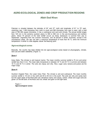
- 1. AGRO-ECOLOGICAL ZONES AND CROP PRODUCTION REGIONS Allah Dad Khan Pakistan is situated between the latitudes of 24° and 37° north and longitudes of 61° to 75° east, stretching over 1 600 kilometres from north to south and 885 kilometres from east to west, with a total area of 796 095 square kilometres. It has a subtropical and semi-arid climate. The annual rainfall ranges from 125 mm in the extreme southern plains to 500 to 900 mm in the sub-mountainous and northern plains. About 70 percent of the total rainfall occurs as heavy downpours in summer from July to September, originating from the summer monsoons, and 30 percent in winter. Summers, except in the mountainous areas, are very hot with a maximum temperature of more than 40 °C, while the minimum temperature in winter is a few degrees above the freezing point. Agro-ecological zones Basically, the country has been divided into ten agro-ecological zones based on physiography, climate, land use and water availability (Figure 1). Zone I Indus Delta. The climate is arid tropical marine. The mean monthly summer rainfall is 75 mm and winter rainfall less than 5 mm. The mean daily temperature is between 34 °C and 40 °C in summer and between 19 °C and 20 °C in winter. The soils are clayey and silty. Rice, sugar cane, banana and pulses are the major crops. Zone II Southern Irrigated Plain, the Lower Indus Plain. The climate is arid and subtropical. The mean monthly summer rainfall is 18 mm in the north and 45 to 55 mm in the south. The soils are silty and sandy loam but the upper areas of the flood plain are calcareous loamy and clayey. Cotton, wheat and sugar cane are grown on the left bank of the Indus and rice, wheat and gram on the right bank. Figure 1 Agro-ecological zones
- 2. Source PARC, 1980 Zone IIIa Sandy Desert (a). The maximum rainfall is 300 mm. The soils are sandy and loamy fine sand. The land is used for grazing. Zone IIIb Sandy Desert (b) - sand ridges and dunes. The rainfall is between 300 and 350 mm. The soils are sandy and loamy fine sand. The land is used for grazing. Zone IVa Northern Irrigated Plain (a) - Flood Plains and Bar Uplands. The climate is semi-arid to arid. The mean annual rainfall is 300 to 500 mm in the east and 200 to 300 mm in the southwest. The soils are sandy , loam-clay and loam. The canal irrigated crops are wheat, rice, sugar cane, oilseed and millets in the north and wheat, cotton, sugar cane, maize, citrus and mangoes in the centre and south. Zone IVb Northern Irrigated Plain (b) - alluvial valleys of Peshawar and Mardan. The climate is semi-arid. The mean monthly rainfall is 20 to 30 mm. The soils are silty clays and clay loams. The main crops are sugar cane, maize, tobacco, wheat, berseem, sugar beet and orchards.
- 3. Zone V Barani (rainfed) Lands. This covers the Salt Range and the Potwar Plateau. In the North the mean monthly rainfall is 200 mm in summer and 35 to 50 mm in winter. The climate in the Southern part is semi-arid and hot. The mean monthly rainfall is 85 mm in summer and 30 to 45 mm in winter. The main crops are wheat, millet, oilseed and pulses. Zone VI Wet Mountains - High Mountains. The mean monthly rainfall is 235 mm in summer and 116 mm in winter. The soils consist of silt loams to silty clays. A small area is under rainfed agriculture but most of it is under forest. Zone VII Northern Dry Mountains. The mean monthly rainfall is 25 to 75 mm in winter and 10 to 20 mm in summer. The valley soils are deep and clayey. Most of the area is used for grazing. Zone VIII Western Dry Mountains. They are composed of barren hills with steep slopes. The mean monthly rainfall is 95 mm in summer and 63 to 95 mm in winter. The soils in the valleys are deep and loamy. Most of the land is used for grazing. On part of the loamy soils wheat and fruit crops are grown. Zone IX Dry Western Plateau - mountainous areas. The mean monthly rainfall is 37 mm in summer. The coastal belt receives a sea breeze. The land is used mainly for grazing. Melons, fruit crops, vegetables and wheat are grown where water is available. FIGURE 2 Dominant soil map of Pakistan (Original scale: 1:5 million)
- 4. Source: FAO/UNESCO Zone X Sulaiman Piedmont - plains of the Sulaiman Range. The climate is arid and hot. The mean monthly rainfall is less than 15 mm. Irrigation relies on floods of the hill torrents. Wheat, millet and gram are the main crops.