Cmp wms -1 a-survey-rev.1- 03-03-10
•Transferir como DOCX, PDF•
0 gostou•527 visualizações

method statement survey

Recomendados
Recomendados
Mais conteúdo relacionado
Mais de Siddhartha Bhamidipati
Último
Último (20)
Cmp wms -1 a-survey-rev.1- 03-03-10
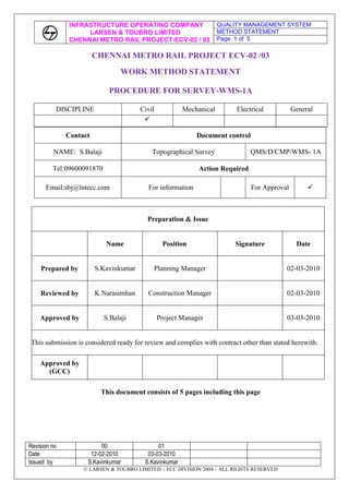
- 1. CHENNAI METRO RAIL PROJECT ECV-02 /03<br />WORK METHOD STATEMENT<br />PROCEDURE FOR SURVEY-WMS-1A<br />DISCIPLINECivilMechanicalElectricalGeneral<br />ContactDocument controlNAME: S.BalajiTopographical SurveyQMS/D/CMP/WMS- 1ATel:09600091870Action RequiredEmail:sbj@lntecc.comFor informationFor Approval<br />Preparation & IssueNamePositionSignatureDatePrepared byS.KavinkumarPlanning Manager02-03-2010Reviewed byK.NarasimhanConstruction Manager02-03-2010Approved byS.BalajiProject Manager03-03-2010This submission is considered ready for review and complies with contract other than stated herewith.Approved by(GCC)<br />This document consists of 5 pages including this page<br />CONTENTS<br />Sl No.ContentPage no.01Preamble302Manpower, Machineries & Equipment303Work Methodology404Environment, Health & Safety505Formats / Reports5<br />SURVEY METHODOLOGY<br />FOR CHENNAI METRO PROJECT-VIADUCT SURVEY CHENNAI<br />INTRODUCTION:<br /> The following mentioned methodology shall be adopted by M/s National Survey and Engineers for carrying out topographical survey for the projects ECV02 & ECV03 of CMRL phase I for the sector Ashok Nagar to St. Thomas mount and from Saidapet to OTA.<br />1. PREAMBLE.<br />The object of this Method Statement is to lay down a procedure for survey works of the Project such as setting out the horizontal and vertical control points, setting out the project highway alignment and taking Original Ground Levels of the project highway etc,. <br /> <br /> 2. MANPOWER, MACHINERY & EQUIPMENT: <br /> 2.1 MANPOWER:<br />Sl.NoDescriptionRequirementRemarks1Survey Engineer12Surveyors23Helper4<br />2.2 MACHINERY & EQUIPMENT: <br />Sl.NoDescriptionRequirementRemarks1Total Station with Sighting Prism22Auto level23Leveling Staff44Measuring Tape45Other ToolsAs per the site Requirement<br />Apparatus: The following survey instruments shall be deployed for the survey job:<br />Leica GX1230 Differential GPS with L1 and L2 frequency - 1 Base and 1 Rover.<br /> Electronic Total Station instruments - 2 to 3 No.<br />Digital Level DN10.<br />3. WORK METHODOLOGY:<br />Pillars Fixing<br />DGPS Network survey for the proposed area.<br />Leveling to connect all network stations<br />Detailed topo Survey.<br /> 3.1 PILLAR FIXING: <br />RCC Pillars of both GPS and secondary pillars as prescribed size shall be fixed at the locations along the stretch as decided by the site Engineer-in-charge.<br /> 3.2 DGPS network Survey:<br />After making reconnaissance survey of the area, DGPS network station is selected to fix Primary Control Points for the interval of every 5km.<br />Data Collection:<br />Keeping the DGPS Receiver at 0 km chainage and another DGPS Receiver at 5th km control station point, the data shall be collected using satellites for maximum duration of 1 hour simultaneously. In the similar manner, the data is collected for all other Primary control points.<br />Processing: <br />The collected DGPS data is downloaded from the Receivers to the Computer and the data is processed using the Leica Geo Office software until the ambiguity is resolved. <br />Processing Parameters: <br />Ellipsoid: WGS-84 <br />Semi Major Axis (a): 6378137.00<br />Flattening (1/f): 298.257223563<br />Projection: UTM <br />Zone width: 6 wide<br />False Easting: 500000 at CM <br /> Scale Factor at CM: 0.9996<br /> False Northing: 0.000 at Equator<br />After processing the data, we get Slope/Grid distance and Azimuth between the stations as well as co-ordinates in WGS-84 system. <br />Chainage marking:<br /> Chainage shall be marked from starting point to end point at every 20 m interval to facilitate to take cross section details<br />Horizontal Traverse Survey:<br /> Horizontal traverse stations at 200-250 m interval shall be established all along the route of survey. Using the Electronic Total Station instrument horizontal traverse shall be carried from one DGPS station to another station taking angles and distance in both faces left and face right values. In addition to this, we establish Traverse stations at various intervals to facilitate detailed topographical survey. The horizontal traverse accuracy shall be 1 in 20000.<br />3.3 Leveling:<br /> The entire Primary, secondary and all Traverse stations are connected by using Digital level from the known or identified BM to get the elevation or height. The leveling accuracy shall be 12√k.<br />3.4 Detailed Topographical Survey:<br /> From the established primary, secondary and Traverse stations as per specifications all the existing features, shall be captured by using Electronic Total Station.<br />Drawing:<br /> The field data collected with DGPS and Electronic Total Station instruments would be downloaded into computer and as per code drawing will be prepared using Auto CAD. Drawing print out copy shall be taken to field to cross check with ground features. If there is any omission that shall be rectified. Final drawing shall be submitted with all field data in soft copy and report in hard copy.<br />4. Environment Health & Safety:<br /> All the staff and work men shall be provided with necessary personal protective equipment.(Safety jackets, safety helmets and safety shoes) always at site.<br />All the works shall be carried out in order to maintain clean environment and no damage will occur to any property or public amenities.<br />5. Reports<br />The field data collected with DGPS and electronic Total station instruments shall be downloaded into computer and as per code drawing shall be prepared in AutoCAD. Drawing printout copy shall be taken to field and physically cross checked. If there is any omissions or commission shall be rectified. Final drawing shall be submitted with all field data in soft copy and reports in hard copy.<br />