SlideShare uma empresa Scribd logo
1 de 2
Baixar para ler offline
The Free Software Geobrowser


Marble – a virtual globe ...
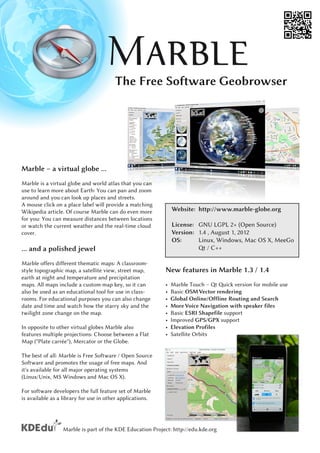
Marble is a virtual globe and world atlas that you can
use to learn more about Earth: You can pan and zoom
around and you can look up places and streets.
A mouse click on a place label will provide a matching
Wikipedia article. Of course Marble can do even more           Website: http://www.marble-globe.org
for you: You can measure distances between locations
or watch the current weather and the real-time cloud           License: GNU LGPL 2+ (Open Source)
cover.                                                         Version: 1 .4 , August 1 , 201 2
                                                               OS:      Linux, Windows, Mac OS X, MeeGo
... and a polished jewel                                                   Qt / C++
Marble offers different thematic maps: A classroom-
style topographic map, a satellite view, street map,       New features in Marble 1 .3 / 1 .4
earth at night and temperature and precipitation
maps. All maps include a custom map key, so it can         •   Marble Touch – Qt Quick version for mobile use
also be used as an educational tool for use in class-      •   Basic OSM Vector rendering
rooms. For educational purposes you can also change        •   Global Online/Offline Routing and Search
date and time and watch how the starry sky and the         •   More Voice Navigation with speaker files
twilight zone change on the map.                           •   Basic ESRI Shapefile support
                                                           •   Improved GPS/GPX support
In opposite to other virtual globes Marble also            •   Elevation Profiles
features multiple projections: Choose between a Flat       •   Satellite Orbits
Map ("Plate carrée"), Mercator or the Globe.
The best of all: Marble is Free Software / Open Source
Software and promotes the usage of free maps. And
it's available for all major operating systems
(Linux/Unix, MS Windows and Mac OS X).
For software developers the full feature set of Marble
is available as a library for use in other applications.


                 Marble is part of the KDE Education Project: http://edu.kde.org
Find Your Way and Explore the World
Features
Easy to Use
Intuitive map navigation allows for panning and
zooming. Map data is automatically being down-
loaded in the background and cached on the hard
disc.
Standard Map Themes
Atlas, Satellite, OpenStreetMap, Plain Map, Earth at
Night, Historical Map, Moon Map and more.
Map Data (Tile Server Layouts)
Multiple layers of data can be specified and blended               A KML file displaying the US states in Marble
via filters. Marble also provides a map creation wizard
for users. Supported tile layout schemes include:
• OpenStreetMap, Google Maps, Ovi Maps
• WMS support
• Custom Server Layouts (specified via XML)
Projections
Globe, Equirectangular, Mercator
Supported File Formats
• KML / Google Earth(TM) user data, no KMZ
• GPX, OSM, SH P, more formats via plugins
Position Providers
GPS (via gpsd, Qt Mobility, GeoClue, Maemo 5)
Routing                                                                        OpenSeaMap with multiple layers
The user interface allows for entering routes via drag
and drop. The technical specs include:
• Global Online Routing, Yours, OpenRouteService,
  OSRM, MapQuest
• Offline Routing: Monav, Routino, Gosmore
• Plugin based routing backends
• Turn-By-Turn Navigation, Voice Navigation
• Profiles (fastest/shortest Car, Bicycle, Pedestrian)
• Via points and alternative route suggestions
• Elevation profiles
Wikipedia Integration                                                  Marble running on a Nokia N900 in a car
And more ...
Software developers can extend Marble via plugins or         http://www.marble-globe.org
they can embed it into their own applications.
Community and commercial support available.

                 Marble is part of the KDE Education Project: http://edu.kde.org

Mais conteúdo relacionado

Mais procurados

Google Earth Basics
Google Earth BasicsGoogle Earth Basics
Google Earth Basicsteedawg12
 
OpenLayers vs. Leaflet
OpenLayers vs. LeafletOpenLayers vs. Leaflet
OpenLayers vs. Leafletdasjo
 
Google map and navigation
Google map and navigation Google map and navigation
Google map and navigation Shalikram Patel
 
PoliMappers - Introduction to OpenStreetMap
PoliMappers - Introduction to OpenStreetMapPoliMappers - Introduction to OpenStreetMap
PoliMappers - Introduction to OpenStreetMapFederica Gaspari
 
NEARC 2009 CUNY Mapping Service
NEARC 2009 CUNY Mapping ServiceNEARC 2009 CUNY Mapping Service
NEARC 2009 CUNY Mapping Servicesromalewski
 
Nottingham hack soc
Nottingham hack socNottingham hack soc
Nottingham hack socSK53
 
Of Nodes and Maps (Web Mapping with Drupal - Part II)
Of Nodes and Maps (Web Mapping with Drupal - Part II)Of Nodes and Maps (Web Mapping with Drupal - Part II)
Of Nodes and Maps (Web Mapping with Drupal - Part II)Ranel Padon
 
Web Mapping with Drupal
Web Mapping with DrupalWeb Mapping with Drupal
Web Mapping with DrupalRanel Padon
 
powerpoint de prueba
powerpoint de pruebapowerpoint de prueba
powerpoint de pruebaguest24e7e8
 
Procedural map generation for a RTS game
Procedural map generation for a RTS gameProcedural map generation for a RTS game
Procedural map generation for a RTS gamekeldon_spain
 
The GRASS GIS software (with QGIS) - GIS Seminar
The GRASS GIS software (with QGIS) - GIS SeminarThe GRASS GIS software (with QGIS) - GIS Seminar
The GRASS GIS software (with QGIS) - GIS SeminarMarkus Neteler
 

Mais procurados (16)

Google Earth Basics
Google Earth BasicsGoogle Earth Basics
Google Earth Basics
 
OpenLayers vs. Leaflet
OpenLayers vs. LeafletOpenLayers vs. Leaflet
OpenLayers vs. Leaflet
 
Google map and navigation
Google map and navigation Google map and navigation
Google map and navigation
 
PoliMappers - Introduction to OpenStreetMap
PoliMappers - Introduction to OpenStreetMapPoliMappers - Introduction to OpenStreetMap
PoliMappers - Introduction to OpenStreetMap
 
NEARC 2009 CUNY Mapping Service
NEARC 2009 CUNY Mapping ServiceNEARC 2009 CUNY Mapping Service
NEARC 2009 CUNY Mapping Service
 
Nottingham hack soc
Nottingham hack socNottingham hack soc
Nottingham hack soc
 
Lecture OSSIM
Lecture OSSIM Lecture OSSIM
Lecture OSSIM
 
Of Nodes and Maps (Web Mapping with Drupal - Part II)
Of Nodes and Maps (Web Mapping with Drupal - Part II)Of Nodes and Maps (Web Mapping with Drupal - Part II)
Of Nodes and Maps (Web Mapping with Drupal - Part II)
 
Snizek IALUC 2008
Snizek IALUC 2008Snizek IALUC 2008
Snizek IALUC 2008
 
Digital Image Processing
Digital Image ProcessingDigital Image Processing
Digital Image Processing
 
Spatial search with geohashes
Spatial search with geohashesSpatial search with geohashes
Spatial search with geohashes
 
Web Mapping with Drupal
Web Mapping with DrupalWeb Mapping with Drupal
Web Mapping with Drupal
 
HDF-EOS Development Status and Maintenance Support
HDF-EOS Development Status and Maintenance SupportHDF-EOS Development Status and Maintenance Support
HDF-EOS Development Status and Maintenance Support
 
powerpoint de prueba
powerpoint de pruebapowerpoint de prueba
powerpoint de prueba
 
Procedural map generation for a RTS game
Procedural map generation for a RTS gameProcedural map generation for a RTS game
Procedural map generation for a RTS game
 
The GRASS GIS software (with QGIS) - GIS Seminar
The GRASS GIS software (with QGIS) - GIS SeminarThe GRASS GIS software (with QGIS) - GIS Seminar
The GRASS GIS software (with QGIS) - GIS Seminar
 

Semelhante a Marble Virtual Globe 1.4 Factsheet (English)

Answer To Google Earth Universeand Evrything Else Abbreviated
Answer To Google Earth Universeand Evrything Else AbbreviatedAnswer To Google Earth Universeand Evrything Else Abbreviated
Answer To Google Earth Universeand Evrything Else Abbreviatedguestd2ceb9
 
Gisruk2013 addy edit2
Gisruk2013 addy edit2Gisruk2013 addy edit2
Gisruk2013 addy edit2Addy Pope
 
3D Visualization in ArcGIS Pro
3D Visualization in ArcGIS Pro3D Visualization in ArcGIS Pro
3D Visualization in ArcGIS Prothangqd
 
BCS Workshop: Old Maps Online
BCS Workshop: Old Maps OnlineBCS Workshop: Old Maps Online
BCS Workshop: Old Maps OnlinePetr Pridal
 
MapStore Create, save and share maps and mashups @ GRASS-GFOSS 2013
MapStore Create, save and share maps and mashups @ GRASS-GFOSS 2013MapStore Create, save and share maps and mashups @ GRASS-GFOSS 2013
MapStore Create, save and share maps and mashups @ GRASS-GFOSS 2013GeoSolutions
 
Humanitarian OpenStreetMap Team [H.O.T.] Training for SBTF
Humanitarian OpenStreetMap Team [H.O.T.] Training for SBTFHumanitarian OpenStreetMap Team [H.O.T.] Training for SBTF
Humanitarian OpenStreetMap Team [H.O.T.] Training for SBTFStandby Task Force
 
Building a Standards Based Collaborative GIS
Building a Standards Based Collaborative GISBuilding a Standards Based Collaborative GIS
Building a Standards Based Collaborative GISIan Turton
 
Free remote sensing and GIS data
Free remote sensing and GIS dataFree remote sensing and GIS data
Free remote sensing and GIS dataNopphawanTamkuan
 
Location-aware desktop
Location-aware desktopLocation-aware desktop
Location-aware desktopHenri Bergius
 
OldMapsOnline.org: Open Source & Online Tools for Old Maps
OldMapsOnline.org: Open Source & Online Tools for Old MapsOldMapsOnline.org: Open Source & Online Tools for Old Maps
OldMapsOnline.org: Open Source & Online Tools for Old MapsPetr Pridal
 
Mapping, GIS and geolocating data in Java @ JAX London
Mapping, GIS and geolocating data in Java @ JAX LondonMapping, GIS and geolocating data in Java @ JAX London
Mapping, GIS and geolocating data in Java @ JAX LondonJoachim Van der Auwera
 

Semelhante a Marble Virtual Globe 1.4 Factsheet (English) (20)

Hawaii Pacific GIS Conference 2012: Internet GIS - Create Your Own Google Lik...
Hawaii Pacific GIS Conference 2012: Internet GIS - Create Your Own Google Lik...Hawaii Pacific GIS Conference 2012: Internet GIS - Create Your Own Google Lik...
Hawaii Pacific GIS Conference 2012: Internet GIS - Create Your Own Google Lik...
 
Mapping
MappingMapping
Mapping
 
Answer To Google Earth Universeand Evrything Else Abbreviated
Answer To Google Earth Universeand Evrything Else AbbreviatedAnswer To Google Earth Universeand Evrything Else Abbreviated
Answer To Google Earth Universeand Evrything Else Abbreviated
 
Gisruk2013 addy edit2
Gisruk2013 addy edit2Gisruk2013 addy edit2
Gisruk2013 addy edit2
 
3D Visualization in ArcGIS Pro
3D Visualization in ArcGIS Pro3D Visualization in ArcGIS Pro
3D Visualization in ArcGIS Pro
 
Intergeo 2011
Intergeo 2011Intergeo 2011
Intergeo 2011
 
Mapping toolbox
Mapping toolboxMapping toolbox
Mapping toolbox
 
OSM HOT SBTF 2013_03_16
OSM HOT SBTF 2013_03_16OSM HOT SBTF 2013_03_16
OSM HOT SBTF 2013_03_16
 
Maps
MapsMaps
Maps
 
BCS Workshop: Old Maps Online
BCS Workshop: Old Maps OnlineBCS Workshop: Old Maps Online
BCS Workshop: Old Maps Online
 
MapStore Create, save and share maps and mashups @ GRASS-GFOSS 2013
MapStore Create, save and share maps and mashups @ GRASS-GFOSS 2013MapStore Create, save and share maps and mashups @ GRASS-GFOSS 2013
MapStore Create, save and share maps and mashups @ GRASS-GFOSS 2013
 
Humanitarian OpenStreetMap Team [H.O.T.] Training for SBTF
Humanitarian OpenStreetMap Team [H.O.T.] Training for SBTFHumanitarian OpenStreetMap Team [H.O.T.] Training for SBTF
Humanitarian OpenStreetMap Team [H.O.T.] Training for SBTF
 
Building a Standards Based Collaborative GIS
Building a Standards Based Collaborative GISBuilding a Standards Based Collaborative GIS
Building a Standards Based Collaborative GIS
 
Free remote sensing and GIS data
Free remote sensing and GIS dataFree remote sensing and GIS data
Free remote sensing and GIS data
 
Location-aware desktop
Location-aware desktopLocation-aware desktop
Location-aware desktop
 
Geocart workshop
Geocart workshopGeocart workshop
Geocart workshop
 
Using data from Digimap in ArcGIS
Using data from Digimap in ArcGISUsing data from Digimap in ArcGIS
Using data from Digimap in ArcGIS
 
myVR mMap SDK
myVR mMap SDKmyVR mMap SDK
myVR mMap SDK
 
OldMapsOnline.org: Open Source & Online Tools for Old Maps
OldMapsOnline.org: Open Source & Online Tools for Old MapsOldMapsOnline.org: Open Source & Online Tools for Old Maps
OldMapsOnline.org: Open Source & Online Tools for Old Maps
 
Mapping, GIS and geolocating data in Java @ JAX London
Mapping, GIS and geolocating data in Java @ JAX LondonMapping, GIS and geolocating data in Java @ JAX London
Mapping, GIS and geolocating data in Java @ JAX London
 

Mais de Marble Virtual Globe

Marble Virtual Globe 1.4 Factsheet (German)
Marble Virtual Globe 1.4 Factsheet (German)Marble Virtual Globe 1.4 Factsheet (German)
Marble Virtual Globe 1.4 Factsheet (German)Marble Virtual Globe
 
Marble Virtual Globe 1.4 Factsheet (Spanish)
Marble Virtual Globe 1.4 Factsheet (Spanish)Marble Virtual Globe 1.4 Factsheet (Spanish)
Marble Virtual Globe 1.4 Factsheet (Spanish)Marble Virtual Globe
 
Marble Virtual Globe 1.4 Factsheet (French)
Marble Virtual Globe 1.4 Factsheet (French)Marble Virtual Globe 1.4 Factsheet (French)
Marble Virtual Globe 1.4 Factsheet (French)Marble Virtual Globe
 
Marble Virtual Globe 1.3 Factsheet (Hindi)
Marble Virtual Globe 1.3 Factsheet (Hindi)Marble Virtual Globe 1.3 Factsheet (Hindi)
Marble Virtual Globe 1.3 Factsheet (Hindi)Marble Virtual Globe
 
Marble Virtual Globe for Developers - Factsheet
Marble Virtual Globe for Developers - FactsheetMarble Virtual Globe for Developers - Factsheet
Marble Virtual Globe for Developers - FactsheetMarble Virtual Globe
 
Marble Virtual Globe 1.3 Factsheet (Spanish)
Marble Virtual Globe 1.3 Factsheet (Spanish)Marble Virtual Globe 1.3 Factsheet (Spanish)
Marble Virtual Globe 1.3 Factsheet (Spanish)Marble Virtual Globe
 
Marble Virtual Globe 1.3 Factsheet (German)
Marble Virtual Globe 1.3 Factsheet (German)Marble Virtual Globe 1.3 Factsheet (German)
Marble Virtual Globe 1.3 Factsheet (German)Marble Virtual Globe
 
Marble Virtual Globe 1.3 Factsheet (French)
Marble Virtual Globe 1.3 Factsheet (French)Marble Virtual Globe 1.3 Factsheet (French)
Marble Virtual Globe 1.3 Factsheet (French)Marble Virtual Globe
 
Towards Marble 2.0 - the journey around a virtual globe
Towards Marble 2.0 - the journey around a virtual globeTowards Marble 2.0 - the journey around a virtual globe
Towards Marble 2.0 - the journey around a virtual globeMarble Virtual Globe
 
Developing Qt Applications on MeeGo Touch with Style
Developing Qt Applications on MeeGo Touch with StyleDeveloping Qt Applications on MeeGo Touch with Style
Developing Qt Applications on MeeGo Touch with StyleMarble Virtual Globe
 
Finding direction marble goes mobile
Finding direction marble goes mobileFinding direction marble goes mobile
Finding direction marble goes mobileMarble Virtual Globe
 

Mais de Marble Virtual Globe (17)

Marble Virtual Globe 1.4 Factsheet (German)
Marble Virtual Globe 1.4 Factsheet (German)Marble Virtual Globe 1.4 Factsheet (German)
Marble Virtual Globe 1.4 Factsheet (German)
 
Marble Virtual Globe 1.4 Factsheet (Spanish)
Marble Virtual Globe 1.4 Factsheet (Spanish)Marble Virtual Globe 1.4 Factsheet (Spanish)
Marble Virtual Globe 1.4 Factsheet (Spanish)
 
Marble Virtual Globe 1.4 Factsheet (French)
Marble Virtual Globe 1.4 Factsheet (French)Marble Virtual Globe 1.4 Factsheet (French)
Marble Virtual Globe 1.4 Factsheet (French)
 
Marble Virtual Globe 1.3 Factsheet (Hindi)
Marble Virtual Globe 1.3 Factsheet (Hindi)Marble Virtual Globe 1.3 Factsheet (Hindi)
Marble Virtual Globe 1.3 Factsheet (Hindi)
 
Marble Virtual Globe for Developers - Factsheet
Marble Virtual Globe for Developers - FactsheetMarble Virtual Globe for Developers - Factsheet
Marble Virtual Globe for Developers - Factsheet
 
Marble Virtual Globe 1.3 Factsheet (Spanish)
Marble Virtual Globe 1.3 Factsheet (Spanish)Marble Virtual Globe 1.3 Factsheet (Spanish)
Marble Virtual Globe 1.3 Factsheet (Spanish)
 
Marble Virtual Globe 1.3 Factsheet (German)
Marble Virtual Globe 1.3 Factsheet (German)Marble Virtual Globe 1.3 Factsheet (German)
Marble Virtual Globe 1.3 Factsheet (German)
 
Marble Virtual Globe 1.3 Factsheet (French)
Marble Virtual Globe 1.3 Factsheet (French)Marble Virtual Globe 1.3 Factsheet (French)
Marble Virtual Globe 1.3 Factsheet (French)
 
Towards Marble 2.0 - the journey around a virtual globe
Towards Marble 2.0 - the journey around a virtual globeTowards Marble 2.0 - the journey around a virtual globe
Towards Marble 2.0 - the journey around a virtual globe
 
Marble Goes MeeGo
Marble Goes MeeGoMarble Goes MeeGo
Marble Goes MeeGo
 
Developing Qt Applications on MeeGo Touch with Style
Developing Qt Applications on MeeGo Touch with StyleDeveloping Qt Applications on MeeGo Touch with Style
Developing Qt Applications on MeeGo Touch with Style
 
Finding direction marble goes mobile
Finding direction marble goes mobileFinding direction marble goes mobile
Finding direction marble goes mobile
 
Marble talk at akademy 2009
Marble talk at akademy 2009Marble talk at akademy 2009
Marble talk at akademy 2009
 
Marble talk at akademy 2008
Marble talk  at akademy 2008Marble talk  at akademy 2008
Marble talk at akademy 2008
 
Marble on mac
Marble on macMarble on mac
Marble on mac
 
Marble routing
Marble routingMarble routing
Marble routing
 
State of the Geodata
State of the GeodataState of the Geodata
State of the Geodata
 

Último

Web & Social Media Analytics Previous Year Question Paper.pdf
Web & Social Media Analytics Previous Year Question Paper.pdfWeb & Social Media Analytics Previous Year Question Paper.pdf
Web & Social Media Analytics Previous Year Question Paper.pdfJayanti Pande
 
Paris 2024 Olympic Geographies - an activity
Paris 2024 Olympic Geographies - an activityParis 2024 Olympic Geographies - an activity
Paris 2024 Olympic Geographies - an activityGeoBlogs
 
How to Make a Pirate ship Primary Education.pptx
How to Make a Pirate ship Primary Education.pptxHow to Make a Pirate ship Primary Education.pptx
How to Make a Pirate ship Primary Education.pptxmanuelaromero2013
 
microwave assisted reaction. General introduction
microwave assisted reaction. General introductionmicrowave assisted reaction. General introduction
microwave assisted reaction. General introductionMaksud Ahmed
 
Separation of Lanthanides/ Lanthanides and Actinides
Separation of Lanthanides/ Lanthanides and ActinidesSeparation of Lanthanides/ Lanthanides and Actinides
Separation of Lanthanides/ Lanthanides and ActinidesFatimaKhan178732
 
Accessible design: Minimum effort, maximum impact
Accessible design: Minimum effort, maximum impactAccessible design: Minimum effort, maximum impact
Accessible design: Minimum effort, maximum impactdawncurless
 
CARE OF CHILD IN INCUBATOR..........pptx
CARE OF CHILD IN INCUBATOR..........pptxCARE OF CHILD IN INCUBATOR..........pptx
CARE OF CHILD IN INCUBATOR..........pptxGaneshChakor2
 
A Critique of the Proposed National Education Policy Reform
A Critique of the Proposed National Education Policy ReformA Critique of the Proposed National Education Policy Reform
A Critique of the Proposed National Education Policy ReformChameera Dedduwage
 
Employee wellbeing at the workplace.pptx
Employee wellbeing at the workplace.pptxEmployee wellbeing at the workplace.pptx
Employee wellbeing at the workplace.pptxNirmalaLoungPoorunde1
 
Z Score,T Score, Percential Rank and Box Plot Graph
Z Score,T Score, Percential Rank and Box Plot GraphZ Score,T Score, Percential Rank and Box Plot Graph
Z Score,T Score, Percential Rank and Box Plot GraphThiyagu K
 
Presentation by Andreas Schleicher Tackling the School Absenteeism Crisis 30 ...
Presentation by Andreas Schleicher Tackling the School Absenteeism Crisis 30 ...Presentation by Andreas Schleicher Tackling the School Absenteeism Crisis 30 ...
Presentation by Andreas Schleicher Tackling the School Absenteeism Crisis 30 ...EduSkills OECD
 
mini mental status format.docx
mini    mental       status     format.docxmini    mental       status     format.docx
mini mental status format.docxPoojaSen20
 
The basics of sentences session 2pptx copy.pptx
The basics of sentences session 2pptx copy.pptxThe basics of sentences session 2pptx copy.pptx
The basics of sentences session 2pptx copy.pptxheathfieldcps1
 
Grant Readiness 101 TechSoup and Remy Consulting
Grant Readiness 101 TechSoup and Remy ConsultingGrant Readiness 101 TechSoup and Remy Consulting
Grant Readiness 101 TechSoup and Remy ConsultingTechSoup
 
Student login on Anyboli platform.helpin
Student login on Anyboli platform.helpinStudent login on Anyboli platform.helpin
Student login on Anyboli platform.helpinRaunakKeshri1
 
Introduction to ArtificiaI Intelligence in Higher Education
Introduction to ArtificiaI Intelligence in Higher EducationIntroduction to ArtificiaI Intelligence in Higher Education
Introduction to ArtificiaI Intelligence in Higher Educationpboyjonauth
 
Industrial Policy - 1948, 1956, 1973, 1977, 1980, 1991
Industrial Policy - 1948, 1956, 1973, 1977, 1980, 1991Industrial Policy - 1948, 1956, 1973, 1977, 1980, 1991
Industrial Policy - 1948, 1956, 1973, 1977, 1980, 1991RKavithamani
 

Último (20)

Web & Social Media Analytics Previous Year Question Paper.pdf
Web & Social Media Analytics Previous Year Question Paper.pdfWeb & Social Media Analytics Previous Year Question Paper.pdf
Web & Social Media Analytics Previous Year Question Paper.pdf
 
Paris 2024 Olympic Geographies - an activity
Paris 2024 Olympic Geographies - an activityParis 2024 Olympic Geographies - an activity
Paris 2024 Olympic Geographies - an activity
 
How to Make a Pirate ship Primary Education.pptx
How to Make a Pirate ship Primary Education.pptxHow to Make a Pirate ship Primary Education.pptx
How to Make a Pirate ship Primary Education.pptx
 
microwave assisted reaction. General introduction
microwave assisted reaction. General introductionmicrowave assisted reaction. General introduction
microwave assisted reaction. General introduction
 
Separation of Lanthanides/ Lanthanides and Actinides
Separation of Lanthanides/ Lanthanides and ActinidesSeparation of Lanthanides/ Lanthanides and Actinides
Separation of Lanthanides/ Lanthanides and Actinides
 
Mattingly "AI & Prompt Design: Structured Data, Assistants, & RAG"
Mattingly "AI & Prompt Design: Structured Data, Assistants, & RAG"Mattingly "AI & Prompt Design: Structured Data, Assistants, & RAG"
Mattingly "AI & Prompt Design: Structured Data, Assistants, & RAG"
 
Accessible design: Minimum effort, maximum impact
Accessible design: Minimum effort, maximum impactAccessible design: Minimum effort, maximum impact
Accessible design: Minimum effort, maximum impact
 
CARE OF CHILD IN INCUBATOR..........pptx
CARE OF CHILD IN INCUBATOR..........pptxCARE OF CHILD IN INCUBATOR..........pptx
CARE OF CHILD IN INCUBATOR..........pptx
 
A Critique of the Proposed National Education Policy Reform
A Critique of the Proposed National Education Policy ReformA Critique of the Proposed National Education Policy Reform
A Critique of the Proposed National Education Policy Reform
 
Employee wellbeing at the workplace.pptx
Employee wellbeing at the workplace.pptxEmployee wellbeing at the workplace.pptx
Employee wellbeing at the workplace.pptx
 
Z Score,T Score, Percential Rank and Box Plot Graph
Z Score,T Score, Percential Rank and Box Plot GraphZ Score,T Score, Percential Rank and Box Plot Graph
Z Score,T Score, Percential Rank and Box Plot Graph
 
Presentation by Andreas Schleicher Tackling the School Absenteeism Crisis 30 ...
Presentation by Andreas Schleicher Tackling the School Absenteeism Crisis 30 ...Presentation by Andreas Schleicher Tackling the School Absenteeism Crisis 30 ...
Presentation by Andreas Schleicher Tackling the School Absenteeism Crisis 30 ...
 
mini mental status format.docx
mini    mental       status     format.docxmini    mental       status     format.docx
mini mental status format.docx
 
The basics of sentences session 2pptx copy.pptx
The basics of sentences session 2pptx copy.pptxThe basics of sentences session 2pptx copy.pptx
The basics of sentences session 2pptx copy.pptx
 
Grant Readiness 101 TechSoup and Remy Consulting
Grant Readiness 101 TechSoup and Remy ConsultingGrant Readiness 101 TechSoup and Remy Consulting
Grant Readiness 101 TechSoup and Remy Consulting
 
Student login on Anyboli platform.helpin
Student login on Anyboli platform.helpinStudent login on Anyboli platform.helpin
Student login on Anyboli platform.helpin
 
Introduction to ArtificiaI Intelligence in Higher Education
Introduction to ArtificiaI Intelligence in Higher EducationIntroduction to ArtificiaI Intelligence in Higher Education
Introduction to ArtificiaI Intelligence in Higher Education
 
Mattingly "AI & Prompt Design: The Basics of Prompt Design"
Mattingly "AI & Prompt Design: The Basics of Prompt Design"Mattingly "AI & Prompt Design: The Basics of Prompt Design"
Mattingly "AI & Prompt Design: The Basics of Prompt Design"
 
Industrial Policy - 1948, 1956, 1973, 1977, 1980, 1991
Industrial Policy - 1948, 1956, 1973, 1977, 1980, 1991Industrial Policy - 1948, 1956, 1973, 1977, 1980, 1991
Industrial Policy - 1948, 1956, 1973, 1977, 1980, 1991
 
Staff of Color (SOC) Retention Efforts DDSD
Staff of Color (SOC) Retention Efforts DDSDStaff of Color (SOC) Retention Efforts DDSD
Staff of Color (SOC) Retention Efforts DDSD
 

Marble Virtual Globe 1.4 Factsheet (English)

  • 1. The Free Software Geobrowser Marble – a virtual globe ... Marble is a virtual globe and world atlas that you can use to learn more about Earth: You can pan and zoom around and you can look up places and streets. A mouse click on a place label will provide a matching Wikipedia article. Of course Marble can do even more Website: http://www.marble-globe.org for you: You can measure distances between locations or watch the current weather and the real-time cloud License: GNU LGPL 2+ (Open Source) cover. Version: 1 .4 , August 1 , 201 2 OS: Linux, Windows, Mac OS X, MeeGo ... and a polished jewel Qt / C++ Marble offers different thematic maps: A classroom- style topographic map, a satellite view, street map, New features in Marble 1 .3 / 1 .4 earth at night and temperature and precipitation maps. All maps include a custom map key, so it can • Marble Touch – Qt Quick version for mobile use also be used as an educational tool for use in class- • Basic OSM Vector rendering rooms. For educational purposes you can also change • Global Online/Offline Routing and Search date and time and watch how the starry sky and the • More Voice Navigation with speaker files twilight zone change on the map. • Basic ESRI Shapefile support • Improved GPS/GPX support In opposite to other virtual globes Marble also • Elevation Profiles features multiple projections: Choose between a Flat • Satellite Orbits Map ("Plate carrée"), Mercator or the Globe. The best of all: Marble is Free Software / Open Source Software and promotes the usage of free maps. And it's available for all major operating systems (Linux/Unix, MS Windows and Mac OS X). For software developers the full feature set of Marble is available as a library for use in other applications. Marble is part of the KDE Education Project: http://edu.kde.org
  • 2. Find Your Way and Explore the World Features Easy to Use Intuitive map navigation allows for panning and zooming. Map data is automatically being down- loaded in the background and cached on the hard disc. Standard Map Themes Atlas, Satellite, OpenStreetMap, Plain Map, Earth at Night, Historical Map, Moon Map and more. Map Data (Tile Server Layouts) Multiple layers of data can be specified and blended A KML file displaying the US states in Marble via filters. Marble also provides a map creation wizard for users. Supported tile layout schemes include: • OpenStreetMap, Google Maps, Ovi Maps • WMS support • Custom Server Layouts (specified via XML) Projections Globe, Equirectangular, Mercator Supported File Formats • KML / Google Earth(TM) user data, no KMZ • GPX, OSM, SH P, more formats via plugins Position Providers GPS (via gpsd, Qt Mobility, GeoClue, Maemo 5) Routing OpenSeaMap with multiple layers The user interface allows for entering routes via drag and drop. The technical specs include: • Global Online Routing, Yours, OpenRouteService, OSRM, MapQuest • Offline Routing: Monav, Routino, Gosmore • Plugin based routing backends • Turn-By-Turn Navigation, Voice Navigation • Profiles (fastest/shortest Car, Bicycle, Pedestrian) • Via points and alternative route suggestions • Elevation profiles Wikipedia Integration Marble running on a Nokia N900 in a car And more ... Software developers can extend Marble via plugins or http://www.marble-globe.org they can embed it into their own applications. Community and commercial support available. Marble is part of the KDE Education Project: http://edu.kde.org