![Isolines ,[object Object],[object Object]](data:image/gif;base64,R0lGODlhAQABAIAAAAAAAP///yH5BAEAAAAALAAAAAABAAEAAAIBRAA7)
Recomendados
Mais conteúdo relacionado
Mais procurados
Mais procurados (20)
Destaque
Destaque (20)
Semelhante a Lab four isolines and contour lines
Semelhante a Lab four isolines and contour lines (20)
Mais de lschmidt1170
Mais de lschmidt1170 (20)
Último
Último (20)
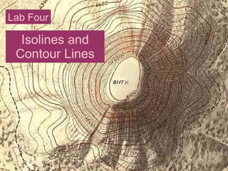
Lab four isolines and contour lines
- 1. Isolines and Contour Lines Lab Four
- 9. http://www.middleschoolscience.com/isotherms.htm Extra Credit Opportunity: Draw in the isolines at 10° intervals for 5 points.
- 13. Simple Contour Line Map and Profile