Submit Search
Upload
Lab four isolines and contour lines
•
Download as PPT, PDF
•
2 likes
•
3,641 views
L
lschmidt1170
Follow
Education
Report
Share
Report
Share
1 of 17
Download now
Recommended
Mercator & Equal Area Projection
Map Projection
Map Projection
mekinglove
the element of regional geography
world regional geography
sodiqin_
Interpolation techniques in ArcGIS
Harsha Chamara
Shift share analysis is a traditional tool; through a descriptive analysis of the productive structure, it allows the comparison of regional differences within a country, region or state (SIMÕES, 2004).Shift-share analysis is one way to account for the competitiveness of a region's industries and to analyze the local economic base. This analysis is primarily used to decompose employment changes within an economy over a specific period of time into mutually exclusive factors. Like other analytical economic tools, the shift-share technique is only a descriptive tool that should be used in combination with other analysis to provide a summary of a region's key employment potential industries.
Shift Share Analysis
Shahadat Hossain Shakil
Cartography is the art, science and technology of map making. Maps are used as research tools and as sources of information. Maps have existed since the time of the Egyptian, Mesopotamian and Chinese civilizations, with the latter maps dating back to 6000 years.
Basics in Cartography
Mohd Akhter Ali
hjgjhg
Cartography intro
Cartography intro
Shreyashi Mitra
Map Projections. In this ppt you will learn how maps are made and how it helps in studying our landforms.
map projections.ppt
map projections.ppt
AntonetteAlbina3
Spatial Analysis Using GIS
Prachi Mehta
Hypsometric curves represent a basin-scale topographic metric, comparable to adjacent basins to distinguish relative age and stage of landscape evolution. These curves are easily derivable in GRASS GIS for no cost. You can find more gis-based geomorphology workflows at my website: https://sites.google.com/site/sorsbysj/ - Skyler Sorsby
Derive hypsometric curves in GRASS GIS
Skyler Sorsby
S1 Unit 2 Geography - Rwanda
Unit 2 Elements of a map.pdf
DUSABIMANA Jean D Amour
This work is an effort to share Geographical Information System: Georeferencing, digitization and map making steps through QGIS 2.0.1 Georeferencing Digitization of Topographical sheet Point Line Area Bihar Map District Headquarters Railway of Bihar District Boundaries Thematic Maps (Literacy & Sex Ratio)
Geographical Information System (GIS) Georeferencing and Digitization, Bihar ...
Kamlesh Kumar
Cartographic map design process and principles
Cartographic map design
Khilaraj Chouhan
Presentation thouth
Presentation thouth
revnnath jedgule
Digital orthophoto
Digital orthophoto
Sumant Diwakar
Open street map final ppt
Prashant Menon
Principle of photogrammetry
Sumant Diwakar
3D GIS brings enhanced depth into data collection and analysis by incorporating a z-value into mapping. Most commonly, that means including elevation data, but users have many options for adding layers of information. While 3D models are more difficult to create and maintain than 2D ones, there are myriad 3D GIS applications where this technology is greatly beneficial. The 3D-GIS in the Cloud main purpose is to evaluate the use-efficiency of both existing and planned spatial space.
3D GIS for urban development
Yash Shah
meaning of symbols, types of symbols, context of symbols in cartography, symbology in GIS, uses of map symbols, types of map symbols
Cartographic symbology. By proj jasper
AgbajiJacob
Von Thunen
Von Thunen
Seth Dixon
Introduction to GIS
Introduction to GIS
Introduction to GIS
Hans van der Kwast
Map is a drawn or printed representation of the physical features of the Earth. It is the best tool to show, understand and analyse the features of an area. Cartography is the art and science of making maps. This module highlights many information on maps, types and their uses.
Maps, cartography and significances
Prof. A.Balasubramanian
zipf's rank size rule and the primacy concept i an important topic for geographers and town planners.
Rank size rule and primate city concept
Tryambakesh Shukla
Presentation on History of Photogrammetry
Historical Development of Photogrammetry
Sabaragamuwa University of Sri Lanka
This presentation is on utm ( universal transverse mercator ) the main content of this presentation are OVERVIEW OF ZONES AND SUBZONES FALSE VALUES OF ORIGIN IDENTIFICATION OF 100*100KM SQ. REGION AND SUB-REGIONS IDENTIFICATION SUMMARY of UTM
UTM UNIVERSAL TRANSVERSE MERCATOR
Muhammad Aamir Manzoor
this presentation can help to explore geography easily
INTRODUCTION TO GEOGRAPHY
Muhammad ahmed
One of most important topics in ArcGIS and GIS, is coordinate system, the slides will cover this topic in order to understand the difference between various coordinate systems.
Coordinate systems
Coordinate systems
Reham Maher El-Safarini
it is very useful for REmote ASensing Student
Remote Sensing
Remote Sensing
guest7b3693
Geography map skill showing how to calculate distance on OS maps.
Scale and distance
Scale and distance
Steven Heath
In this presentation, the University of Cagliari presents the solar photovoltaic pilot projects integrated in 5 public buildings in Cagliari (Italy); Alexandria (Egypt); Beirut (Lebanon); Tunis (Tunisia); and Aqaba (Jordan).
FOSTEr in MED Pilot project Conference in Cagliari 28/06/2016: pilots present...
FOSTEr in MED
Lab five us geological survey topographic maps & us public
lschmidt1170
More Related Content
What's hot
Hypsometric curves represent a basin-scale topographic metric, comparable to adjacent basins to distinguish relative age and stage of landscape evolution. These curves are easily derivable in GRASS GIS for no cost. You can find more gis-based geomorphology workflows at my website: https://sites.google.com/site/sorsbysj/ - Skyler Sorsby
Derive hypsometric curves in GRASS GIS
Skyler Sorsby
S1 Unit 2 Geography - Rwanda
Unit 2 Elements of a map.pdf
DUSABIMANA Jean D Amour
This work is an effort to share Geographical Information System: Georeferencing, digitization and map making steps through QGIS 2.0.1 Georeferencing Digitization of Topographical sheet Point Line Area Bihar Map District Headquarters Railway of Bihar District Boundaries Thematic Maps (Literacy & Sex Ratio)
Geographical Information System (GIS) Georeferencing and Digitization, Bihar ...
Kamlesh Kumar
Cartographic map design process and principles
Cartographic map design
Khilaraj Chouhan
Presentation thouth
Presentation thouth
revnnath jedgule
Digital orthophoto
Digital orthophoto
Sumant Diwakar
Open street map final ppt
Prashant Menon
Principle of photogrammetry
Sumant Diwakar
3D GIS brings enhanced depth into data collection and analysis by incorporating a z-value into mapping. Most commonly, that means including elevation data, but users have many options for adding layers of information. While 3D models are more difficult to create and maintain than 2D ones, there are myriad 3D GIS applications where this technology is greatly beneficial. The 3D-GIS in the Cloud main purpose is to evaluate the use-efficiency of both existing and planned spatial space.
3D GIS for urban development
Yash Shah
meaning of symbols, types of symbols, context of symbols in cartography, symbology in GIS, uses of map symbols, types of map symbols
Cartographic symbology. By proj jasper
AgbajiJacob
Von Thunen
Von Thunen
Seth Dixon
Introduction to GIS
Introduction to GIS
Introduction to GIS
Hans van der Kwast
Map is a drawn or printed representation of the physical features of the Earth. It is the best tool to show, understand and analyse the features of an area. Cartography is the art and science of making maps. This module highlights many information on maps, types and their uses.
Maps, cartography and significances
Prof. A.Balasubramanian
zipf's rank size rule and the primacy concept i an important topic for geographers and town planners.
Rank size rule and primate city concept
Tryambakesh Shukla
Presentation on History of Photogrammetry
Historical Development of Photogrammetry
Sabaragamuwa University of Sri Lanka
This presentation is on utm ( universal transverse mercator ) the main content of this presentation are OVERVIEW OF ZONES AND SUBZONES FALSE VALUES OF ORIGIN IDENTIFICATION OF 100*100KM SQ. REGION AND SUB-REGIONS IDENTIFICATION SUMMARY of UTM
UTM UNIVERSAL TRANSVERSE MERCATOR
Muhammad Aamir Manzoor
this presentation can help to explore geography easily
INTRODUCTION TO GEOGRAPHY
Muhammad ahmed
One of most important topics in ArcGIS and GIS, is coordinate system, the slides will cover this topic in order to understand the difference between various coordinate systems.
Coordinate systems
Coordinate systems
Reham Maher El-Safarini
it is very useful for REmote ASensing Student
Remote Sensing
Remote Sensing
guest7b3693
Geography map skill showing how to calculate distance on OS maps.
Scale and distance
Scale and distance
Steven Heath
What's hot
(20)
Derive hypsometric curves in GRASS GIS
Unit 2 Elements of a map.pdf
Geographical Information System (GIS) Georeferencing and Digitization, Bihar ...
Cartographic map design
Presentation thouth
Presentation thouth
Digital orthophoto
Digital orthophoto
Open street map final ppt
Principle of photogrammetry
3D GIS for urban development
Cartographic symbology. By proj jasper
Von Thunen
Von Thunen
Introduction to GIS
Introduction to GIS
Maps, cartography and significances
Rank size rule and primate city concept
Historical Development of Photogrammetry
UTM UNIVERSAL TRANSVERSE MERCATOR
INTRODUCTION TO GEOGRAPHY
Coordinate systems
Coordinate systems
Remote Sensing
Remote Sensing
Scale and distance
Scale and distance
Viewers also liked
In this presentation, the University of Cagliari presents the solar photovoltaic pilot projects integrated in 5 public buildings in Cagliari (Italy); Alexandria (Egypt); Beirut (Lebanon); Tunis (Tunisia); and Aqaba (Jordan).
FOSTEr in MED Pilot project Conference in Cagliari 28/06/2016: pilots present...
FOSTEr in MED
Lab five us geological survey topographic maps & us public
lschmidt1170
Earth’S Grid
Earth’S Grid
guestdf739ebb
C:\Fakepath\Earth’S Grid
guestdf739ebb
Lab five us geological survey topographic maps & us public
Lisa Schmidt
[Quick guide]sataid for-wis
[Quick guide]sataid for-wis
JMA_447
The dot map and drawing the line of best fit.
Understanding contour lines
enidwray
Syllabus
Summer 2016 geog 110 schmidt
Lisa Schmidt
Lab two location and time
Lisa Schmidt
Four Seasons
Solstice and equinox
Merlyn Denesia
Profile Practice worksheet
West Hollow MS Ms. Gill
AS Geology mapping
AS Geology mapping
angelabentley
surveying
surveying contouring
ANAND JIBHKATE
Isolines and contour lines
lschmidt1170
Topographic Maps
Topographic Maps
rebelbrindley
Isotope isotone isobar
Fendi Ard
Junior Cert Geography, Slides on Depressions and Anticyclones
Depressions and Anticyclones
Noel Hogan
Contouring pdf
Contouring pdf
Gokul Saud
Contour map hw problems
West Hollow MS Ms. Gill
Thinking about your sales team's goals for 2017? Drift's VP of Sales shares 3 things you can do to improve conversion rates and drive more revenue. Read the full story on the Drift blog here: http://blog.drift.com/sales-team-tips
3 Things Every Sales Team Needs to Be Thinking About in 2017
Drift
Viewers also liked
(20)
FOSTEr in MED Pilot project Conference in Cagliari 28/06/2016: pilots present...
Lab five us geological survey topographic maps & us public
Earth’S Grid
Earth’S Grid
C:\Fakepath\Earth’S Grid
Lab five us geological survey topographic maps & us public
[Quick guide]sataid for-wis
[Quick guide]sataid for-wis
Understanding contour lines
Summer 2016 geog 110 schmidt
Lab two location and time
Solstice and equinox
Profile Practice worksheet
AS Geology mapping
AS Geology mapping
surveying contouring
Isolines and contour lines
Topographic Maps
Topographic Maps
Isotope isotone isobar
Depressions and Anticyclones
Contouring pdf
Contouring pdf
Contour map hw problems
3 Things Every Sales Team Needs to Be Thinking About in 2017
Similar to Lab four isolines and contour lines
Isolines and contour lines
lschmidt1170
Isolines and contour lines
lschmidt1170
Lab four isolines and contour lines
Lisa Schmidt
Earth's dimensions
Earth's dimensions
West Hollow MS Ms. Gill
Earths dimension sci 8 ppt np1
West Hollow MS Ms. Gill
12 s080702 e_topography-1
Jenny Dixon
Concept of Isopleth, types, Merits and demerits
Concept of isopleth
Concept of isopleth
Subhasish Sutradhar
This presentation will give you information about Contours, Contour lines. Mapping and Different Geomorphic Features with their Contours
Contouring
Contouring
GeoPresentations
Interpretation of toposheet
Toposheet interpretation
Pramod Hanamgond
topographic maps
Methods of representing physiographic features
venkatesh sambandan
map reading
Maps-and-map-interpretation.docx
shucaybcabdi
EDUCATION
Basic geometry ADAPTED
Elena López Ripoll
Topography and Satellite Notes
Topo and satellite views notes
e045911
What Exactly Is Contouring in Survey & Levelling? It will be helpful for Architectural and Civil engineering students. A presentation by Harshit Gupta (B.Arch 1st year).
Contour lines - Survey & Levelling
Ar. Avitesh
Learning to use a topographic map
Topographic Map
Topographic Map
mjcnavarro
Reading a topographic map
Rachael Hubbard
Earths dimension ppt np1
West Hollow MS Ms. Gill
Lesson 12 intro to topo
jakelederman
Term Paper Coordinate Geometry
Durgesh singh
topographic surveying
06_chapter 7 topographic surveying.pdf
sandipanpaul16
Similar to Lab four isolines and contour lines
(20)
Isolines and contour lines
Lab four isolines and contour lines
Earth's dimensions
Earth's dimensions
Earths dimension sci 8 ppt np1
12 s080702 e_topography-1
Concept of isopleth
Concept of isopleth
Contouring
Contouring
Toposheet interpretation
Methods of representing physiographic features
Maps-and-map-interpretation.docx
Basic geometry ADAPTED
Topo and satellite views notes
Contour lines - Survey & Levelling
Topographic Map
Topographic Map
Reading a topographic map
Earths dimension ppt np1
Lesson 12 intro to topo
Term Paper Coordinate Geometry
06_chapter 7 topographic surveying.pdf
More from lschmidt1170
How did the magna carta influence the united states bill of rights
lschmidt1170
Sustainable development goals
lschmidt1170
Magna cartas lessons for the me
lschmidt1170
What is the magna carta and why there is a google doodle telegraph
lschmidt1170
Universal declaration of human rights
lschmidt1170
Magna carta and the law of nature
lschmidt1170
King john the most evil monarch in britain's history telegraph
lschmidt1170
How did the magna carta influence the united states bill of rights
lschmidt1170
Constitution bill of rights facts
Constitution billofrightsfacts
lschmidt1170
Feudal strength! henry ii and the struggle for royal control in
lschmidt1170
Constitution
Constitution
Constitution
lschmidt1170
Bill of rights
Bill of rights
Bill of rights
lschmidt1170
A magna carta for the earth
A magna carta for the earth oecd observer
lschmidt1170
Family History
Denis haley catherine douglas geneaology 1793 to 1989
lschmidt1170
North America Map One
Na map 1 with terms
Na map 1 with terms
lschmidt1170
intro
Introfall 2016 14week
lschmidt1170
syllabus
Fall 2016 syllabus geog 110 71
lschmidt1170
intro
Intro fall 2016 geog lab
lschmidt1170
intro
Fall 2016 intro wed
Fall 2016 intro wed
lschmidt1170
intro
Fall 2016 intro mon
Fall 2016 intro mon
lschmidt1170
More from lschmidt1170
(20)
How did the magna carta influence the united states bill of rights
Sustainable development goals
Magna cartas lessons for the me
What is the magna carta and why there is a google doodle telegraph
Universal declaration of human rights
Magna carta and the law of nature
King john the most evil monarch in britain's history telegraph
How did the magna carta influence the united states bill of rights
Constitution billofrightsfacts
Feudal strength! henry ii and the struggle for royal control in
Constitution
Constitution
Bill of rights
Bill of rights
A magna carta for the earth oecd observer
Denis haley catherine douglas geneaology 1793 to 1989
Na map 1 with terms
Na map 1 with terms
Introfall 2016 14week
Fall 2016 syllabus geog 110 71
Intro fall 2016 geog lab
Fall 2016 intro wed
Fall 2016 intro wed
Fall 2016 intro mon
Fall 2016 intro mon
Recently uploaded
Year 10 SET Planning session
2024_Student Session 2_ Set Plan Preparation.pptx
mansk2
會考英文
會考英文會考英文會考英文會考英文會考英文會考英文會考英文會考英文會考英文會考英文會考英文
中 央社
https://app.box.com/s/71kthbth9ww0fyjrppmh1p2gasinqj5z
ĐỀ THAM KHẢO KÌ THI TUYỂN SINH VÀO LỚP 10 MÔN TIẾNG ANH FORM 50 CÂU TRẮC NGHI...
Nguyen Thanh Tu Collection
In this slide, we will discuss the features of video calls in the Discuss module in Odoo 17. Odoo Discuss is a built-in communication app that serves as the central hub for all our team conversations. It offers a variety of features to facilitate seamless collaboration and information sharing, including video calls.
Features of Video Calls in the Discuss Module in Odoo 17
Celine George
Sales margin plays a crucial role in the corporate world as a compass that directs enterprises towards profitability. It is the discrepancy between a good or service's selling price and its production or acquisition costs. This margin shows a company's capacity to produce income in addition to how well it manages expenses.
How to Analyse Profit of a Sales Order in Odoo 17
Celine George
This is the finals question set for Post Exam Fun(da) a general quiz hosted by Quiz Master Mr. Sabyasachi Ganguly at the University of Engineering and Management. The quiz focuses on recent news and current affairs in the field of science, technology, management, sports, entertainment industry etc.
Post Exam Fun(da) Intra UEM General Quiz - Finals.pdf
Pragya - UEM Kolkata Quiz Club
This PowerPoint presentation provides an in-depth analysis of "The Ball Poem" by John Berryman. It covers the poem's themes, literary devices, and the author's background, offering a comprehensive understanding of the text. Ideal for students, teachers, and poetry enthusiasts, this presentation delves into the emotional and philosophical dimensions of the poem, highlighting its relevance to the human experience of loss and resilience. Discussion questions and personal response prompts are included to encourage further engagement and reflection.
The Ball Poem- John Berryman_20240518_001617_0000.pptx
NehaChandwani11
Incheon National University Capstone Design Final Presentation - Team Password 486 With Seungjun Rye(CSE), Eunbin Lee(BIZ). Jeonggyo Lee(ECON)
INU_CAPSTONEDESIGN_비밀번호486_업로드용 발표자료.pdf
bu07226
The Dark Web is a part of the internet that is not indexed by traditional search engines like Google, Bing, or Yahoo. It is a subset of the Deep Web, which includes all parts of the internet that are not accessible through standard search engines. The Dark Web requires specific software, configurations, or authorization to access.
Discover the Dark Web .pdf InfosecTrain
infosec train
Slides from a Capitol Technology University presentation covering the doctoral programs offered by the university. Includes information on the degrees available, disciplines offered, modalities, tuition, financial aid and the application process. Presented by members of the faculty assisted by Admissions staff.
Capitol Tech Univ Doctoral Presentation -May 2024
CapitolTechU
STL algorithm SWAP MAX MAX_ELEMENT SORT COUNT COUNT_IF
Stl Algorithms in C++ jjjjjjjjjjjjjjjjjj
Mohammed Sikander
The Last Leaf is a short story by the American writer O. Henry (1862-1910) commonly known in the history of American literature as "the author of surprise ending". It tells the story of an old artist who saves the life of a young neighbouring artist, who is seriously ill and dying, by giving her the will to live. O. Henry knew people very well, especially the ordinary people of New York. In his stories you can feel satirical criticism of the American way of life. Most of his short stories are full of warm sympathy for ordinary American people.
The Last Leaf, a short story by O. Henry
Eugene Lysak
Transport (British English) or Transportation (American English) ransportation has developed along three basic Mode (Media):- 1. Land Transportation (way)– (a) Road Transportation (b) Rail Transportation 2. Water Transportation 3. Air Transportation Tramway Inland water transport Ocean transport These may be classified as under: (a). Liners (b). Tramps Liners Vs Tramps Figure- Layout airport runway design TRAFFIC SIGNS Types of Traffic Signs: 1. Mandatory/Regulatory Signs 2. Cautionary/Warning Signs 3. Informatory/Guide Signs STOP & Give way sign properties as per IS Code IRC 067: Code of Practice for Road Signs (Third Revision) Causes of road accidents ROAD SAFETY MEASURES (1.) Engineering (2.) Enforcement (3.) Education
Basic Civil Engineering notes on Transportation Engineering, Modes of Transpo...
Denish Jangid
For the Closest Location removal strategy, products are picked based on the alphanumeric order of storage location titles. The goal of this strategy is to save the warehouse worker from taking a long journey to a farther shelf when the product is also available at a closer location.
How to Manage Closest Location in Odoo 17 Inventory
Celine George
IATP Guide
IATP How-to Foreign Travel May 2024.pdff
17thcssbs2
muslim law notes
....................Muslim-Law notes.pdf
VikramadityaRaj
Brief presentation of some of the benefits and challenges of using Open Educational Resources in your classes.
Morse OER Some Benefits and Challenges.pptx
jmorse8
Orthodontic treatment involves a delicate balance of science and artistry, where precision is paramount for optimal outcomes. Join us for an enlightening presentation as we explore the nuanced concept of the "Envelope of Discrepancy" within the realm of orthodontics. In this session, we'll embark on a comprehensive journey through the challenges and intricacies of managing discrepancies in orthodontic diagnosis and treatment planning. From assessing dental and skeletal irregularities to understanding soft tissue dynamics, we'll dissect the multifaceted nature of discrepancies and their implications for treatment efficacy. Drawing upon the latest research and clinical insights, we'll unveil practical strategies and innovative techniques aimed at optimizing treatment outcomes while minimizing discrepancies. Whether you're a seasoned orthodontist or a budding practitioner, this presentation promises invaluable knowledge and actionable insights to elevate your practice and enhance patient satisfaction.
Envelope of Discrepancy in Orthodontics: Enhancing Precision in Treatment
saipooja36
reproductive studies of males and females
REPRODUCTIVE TOXICITY STUDIE OF MALE AND FEMALEpptx
manishaJyala2
A Deep look into the diamond district
MichaelStarkes_UncutGemsProjectSummary.pdf
mstarkes24
Recently uploaded
(20)
2024_Student Session 2_ Set Plan Preparation.pptx
會考英文會考英文會考英文會考英文會考英文會考英文會考英文會考英文會考英文會考英文會考英文
ĐỀ THAM KHẢO KÌ THI TUYỂN SINH VÀO LỚP 10 MÔN TIẾNG ANH FORM 50 CÂU TRẮC NGHI...
Features of Video Calls in the Discuss Module in Odoo 17
How to Analyse Profit of a Sales Order in Odoo 17
Post Exam Fun(da) Intra UEM General Quiz - Finals.pdf
The Ball Poem- John Berryman_20240518_001617_0000.pptx
INU_CAPSTONEDESIGN_비밀번호486_업로드용 발표자료.pdf
Discover the Dark Web .pdf InfosecTrain
Capitol Tech Univ Doctoral Presentation -May 2024
Stl Algorithms in C++ jjjjjjjjjjjjjjjjjj
The Last Leaf, a short story by O. Henry
Basic Civil Engineering notes on Transportation Engineering, Modes of Transpo...
How to Manage Closest Location in Odoo 17 Inventory
IATP How-to Foreign Travel May 2024.pdff
....................Muslim-Law notes.pdf
Morse OER Some Benefits and Challenges.pptx
Envelope of Discrepancy in Orthodontics: Enhancing Precision in Treatment
REPRODUCTIVE TOXICITY STUDIE OF MALE AND FEMALEpptx
MichaelStarkes_UncutGemsProjectSummary.pdf
Lab four isolines and contour lines
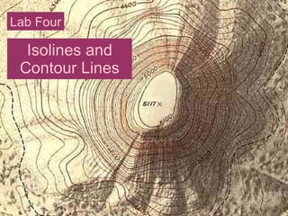
1.
Isolines and Contour
Lines Lab Four
2.
3.
4.
5.
6.
7.
8.
9.
http://www.middleschoolscience.com/isotherms.htm Extra Credit
Opportunity: Draw in the isolines at 10° intervals for 5 points.
10.
11.
12.
13.
Simple Contour Line
Map and Profile
14.
15.
16.
17.
Download now