SlideShare uma empresa Scribd logo
1 de 9
Baixar para ler offline
International Journal of Engineering Inventions
e-ISSN: 2278-7461, p-ISSN: 2319-6491
Volume 3, Issue 6 (January 2014) PP: 08-16

Variations in Groundwater Flow Potential in Parts of Imo State,
Niger Delta Basin, Southeastern Nigeria
C. A. Ahiarakwem, G. I. Nwankwor, E. S.Chinemelu and Paschal, C.C
Department of Geosciences, Federal University of Technology, Owerri, Imo State, Nigeria
ABSTRACT: Groundwater flow potential of ten water boreholes in parts of Imo State were determined
principally from their transmissivity values. The results indicates that the aquifer thickness range from 36 to
50m while the hydraulic conductivity varies from 10-1 to 10-4 m/s. The transmissivity values of the aquifer rocks
varies from 311.04 to 388,072m2/ day. Although the study area is underlain by the same geological formation
(Benin Formation), the groundwater flow potential varies from moderate to high. The highest groundwater flow
potential (388,800m2 /day) was obtained at Futo while the lowest (311.04m2/day) was obtained at Uratta. The
groundwater flow potential of the study area in decreasing order is: Futo 5> Nekede 1 > Ihiagwa 4 > Aba
Rd>8 > Njoku sawmill > Concorde > Aladinma > Naze > Amazu > Uratta 3. The study area is segmented into
two: areas characterized by moderate potential and those that has high groundwater flow potential. Uratta- 3
and Amazu wells are characterized by moderate groundwater flow potential while the rest are characterized by
high potential.
The groundwater flow potential can be employed in sustainable groundwater management and development in
the study area.
Keywords: Aquifer Rock, Transmissivity, Hydraulic Conductivity, Borehole and Groundwater Potential

I. INTRODUCTION
The study area (Figure 1) is located in Imo State,Niger Delta Basin, Southeastern Nigeria. The area lies
within the equatorial rain forest belt of Nigeria which has a mean annual rainfall of 3,100mm (National Root
Crop Research Insitute,2012). Nigeria is blessed with abundant surface and groundwater resources. The water
resources master plan for Nigeria which was prepared by the Japan International Co-operation Agency (JICA) in
2006 indicates an estimated surface water resources of 2.67 x 10¹¹ m3/year groundwater storage of about 0.52 x
1011 m3/year (Oteze,2006). These figures greatly outweigh the Country , s total water demand of about 0.40 x
1011 m3/year (Oteze,2006). . However, many Nigerians are yet to have access to groundwater resources. This is
partly becausemost borehole contracts are awarded on the basis of political expediency rather than geological
or engineering considerations. Aquifer parameters such as well yield, draw down, hydraulic conductivity,
aquifer thickness and transmissivity are rarely determined. Some studies (Iduma and Abam, 2010; Ahiarakwem
and Ejimadu, 2002; Ezeigbo, 1989; Uma, 1984 Etu-Efeotor and Odigi, 1983) have been carried out on some
aspects of the hydrogeology of Southeastern Nigeria of which the study area is a part, the flow potential of the
groundwater resources in the area is yet to be studied. The flow potential of groundwater is a measure of the
transmissivity or transmibility of the aquifer. The transmissivity is the product of the aquifer thickness and
hydraulic conductivity. The flow potential of groundwater resources is essential in the planning of Regional
water supply projects. It is also essential for private groundwater development.
Transmissivity values can vary within short intervals in a particular geological formations; this calls for
careful monitoring of transmissivity values. In groundwater exploration, areas with higher transmissivity values
are usually preferred to areas with lower values in citing satelliteborehole projects. Private borehole construction
in the study area is on the increase; indiscriminate sinking of boreholes can result in the interference of water
table as the safe distance to the next borehole (radius of influence) are rarely determined (Offidile, 1983). This
can effect the draw down of the groundwater resources as well as wide spread water-borne epidemic. One
approach to putting in place appropriate mitigation measure to guard aains this problem is the monitoring of the
groundwater flow potential in the study area.

II. GEOLOGY AND HYDROLOGY
The Teriary Nger Delta Basin of which the study area is a part consists of three major stragraphic
Formations, namely (from top to bottom) :Benin, Agbada and Akata Formations. (Short and Stauble, 1967; ).
However, the study area is precisely underlain by the Benin Formation (Figure 1) which consists of friable
sands, conglomerates, very coarse sandstone and isolated gravel units and intercalations of shale/clay lenses of
Pliocene to Miocene age(Horton, 1965; Short and Stauble, 1967; Ananaba et al., 1993)). The mean thickness of
the formation in the study area is about 800m while the mean depth to water table is about 18.3m (Avbovbo,
1978). The formation is overlain by Alluvium deposits and underlain by the Ogwashi-Asaba Formation which

www.ijeijournal.com

Page | 8
Variations in Groundwater Flow Potential in Parts of Imo State, Niger Delta…
consists of lignite, sandstones, clays and shale (Figure 2). The Benin Formation provides the aquifer for
groundwater storage because of its high porosity and permeability. The incidence of high porosity and
permeability as well as shallow water table makes the groundwater in the area very vulnerable to pollution.
The stuy area is drained by Otamiri, Oramiriukwa and Nworie Rivers. The Otaimiri and Oramiriuka
rivers have a confluence at the southern part (Figure 2) from where both flows together into the Atlantic ocean.
The Nworie river on the other hand is the tributary of the Otamii River. These rivers re used for domestic and
commercial water supply as well as for recreation, fishing and sand mining activities. They also serve as
research and tourist and are also used for transportation. The rivers have deposited large deposits at their banks
over the years most of which now serve as aquifer rocks.

III. MATERIALS AND METHODS
Ten boreholes (Nekede, Aladinma, Uratta, Ihiagwa, FUTO, Naze, Njoku sawmill, Eziobodo, Concorde
and Amuzu) were investigated. The static water table of the boreholes were measured using water level
indicator while the strata logs were cproceww3d using Strata software (version 3 ) and subsequently used to
determine the aquifer thickness. The hydraulic conductivity was determined using method described by
Hubbert (1956) while the Transmissivity values were calculated using equation 1 described by Todd (1980).
T = KD………………………………………………………….. (Equa. 1)
Where
T= Transmissivity,
K= Hydraulic Conductivity
D= Aquifer Thickness
Contour maps of the aquifer thickness, hydraulic conductivity and transmissivity were carried out with the aid
of Surfer 11 software. The computed transmissiviy values were interpreted using the chart described by Offidile
(1983).

IV. RESULTS AND DISCUSSION
The results of this investigation is summarized in Table 1. The transmmissivity values varies from one
borehole to another although the boreholes are located within the same geological formation (Benin
Formation).This implies variations in the groundwater potential of the study area.
4.1 Nekede 1
The lithlogical succession of this borehole shows that it consists essentially of lateritic cover, sandy
clay, sands and gravel (Table1and Figure 2) . The total depth of the borehole is about 60m while the aquifer
thickness and static water table are 44.8 and 18.2m respectively. The aquifer is unconfined with a hydraulic
conductivity of 0.1m/s and a transimmissivity of387, 072m/day (Table1). The transmissivity value indicates
high groundwater flow potential (Table2). The groundwater potential is favorable for sustainable groundwater
development.
4.2 Aladinma
The total depth and static water level of this borehole are 80 and 30m respectively while the aquifer
thickness is about 50m (Table 1). The aquifer is unconfined and has a hydraulic conductivity and
transmissivity values of 10-3 m/sand 4,320m’/day respectively. The lithologic succession in the borehole
consists of lateritic cover, sands and sandstone (Table 1 and Figure 2). The transmissivty value although lower
than that of Nekede is high and thus indicates high groundwater flow potential (Table 2).
4.3 Uratta -3
The total depth of the borehole is about 90m while the aquifer thickness is about 36m. The aquifer is
unconfined with a static water level of about 54m. The lithologic succession include laterite, sands and gravel
(Table 1 and Figure 2). The hydraulic conductivity and transmissivity of the aquifer are 10-4 m/s and
311.04m2/day respectively. This borehole has the lowest groundwater flow potential in the study area, The
groundwater flow potential is considered moderate (Table 2).
4.4 Ihiagwa -4
The total depth of the borehole is about 65m while the aquifer thickness is about 39m. The aquifer is
unconfined with a static water table of about 26m. The lithologic succession in the well include laterite, silts,
sands, sandy clay and gravel (Table 1 and Figure 2). The hydraulic conductivity and transmissivity are 10-1 m/s
and 336,960m2/day respectively and this implies high groundwater flow potential (Table 2).

www.ijeijournal.com

Page | 9
Variations in Groundwater Flow Potential in Parts of Imo State, Niger Delta…
4.5 FUTO - 5
The total depth of the borehole is about 60m with an aquifer thickness of about 45m (Table 1). The
aquifer is unconfined with a static water table of about 15m. The lithologic succession consists essentially of
laterite, silts, sands and gravel (Table 1and Figure 2). The hydraulic conductivity is about 10-1 m/s while the
transmissivity is about 388,800m2/day and this is the highest in the study area.The groundwater flow potential is
also high (Table 2).
4.6 Naze
The total depth of this well is about 60m with an aquifer thickness of about 38m. The static water table
is 22m. The strata log of this well shows that it consists of laterite,silt, sandy clay and gravel (Table 1and Figure
2). The hydraulic conductivity and transmissivity value are 10-3 m/s and 3,283.2m2/day respectively. This also
indicates high groundwater flow potential (Table 2).
4.7 Njoku sawmill
This well has a total depth of about 70m and aqufer thickness of about 49m (Table 1). The static water
table is about 21m while the lithologic succession include laterite, sands , clay and gravel (Table 1and Fjgure
2). It has an unconfined aquifer.The hydraulic conductivity is 10-2 m/s while the transmissivity value is
42,366m2/day. This well is also characterized by high groundwater flow potential (Table 2) and thus quite
suitable for sustainable groundwater development. The aquifer is unconfined.
4.8 Aba Rd. -8
The total depth of this well I is about 80m while the aquifer thickness is about 50m. The static water
table js about 30mand the aquifer is unconfined . The strata log of this well consists of laterite,silt, sandy clay
and sands (Table 1 and Figure 2). The hydraulic conductivity and transmissivity values of the well are10-2
m/sand 43,200m2/day respectively and this indicates high groundwater flow potential (Table 2).
4.9 Concorde 9
The total depth of this well is 70m while the thickness of the aquifer which is unconfined is is about
40m. The static water table is about 30m. The strata log of well include lateterite, sandy clay, sand and gravel
(Table 1and Figure 2). The hydraulic conductivity and transmissivity values are 10-2 m/s and 34,560m2/day. The
groundwater flow potential is also high (Table 2).
4,10 Amuzu
The total depth of this borehole is about 80m while the aquifer thickness is about 45m. The aquifer is
unconfined and the static water table of the well is about 35m. The lithologic succession include laterite, sandy
clay and sand (Table 1 and Figure 2). The hydraulic conductivity is 10-4 m/s while the transmissivit is
388.8m2/day. However, the groundwater flow potential of this well is moderate (Table 2).

V.

GROUNDWATER FLOW POTENTIAL MODEL

The groundwater flow potential of thestudy area in decreasing order is: Futo 5> Nekede 1 > Ihiagwa 4
> Aba Rd>6 > Njoku sawmill > Concorde > Aladinma > Naze > Amazu > Uratta 3 (Table 3). The study area is
segmented into two: areas characterized by moderate and high groundwater flow potential. Uratta- 3 and
Amazu wells are characterized by moderate groundwater flow potential while the rest are characterized by high
potential (Figure 3). The groundwater flow potential trend depends on the aquifer thickness (Figure 4) and the
hydraulic conductivity (Figure 5). Generally, the flow potential decreases with decrease in hydraulic
conductivity (Table 3). Contour maps of aquifer thickness (Figure 6) and hydraulic conductivity (Figure 7) is
consistent with the groundwater flow potential model (Figure 3) of the study area. The model indicates that the
groundwater flow potential generally increases from North to South.

VI. CONCLUSIONS
The results of this study indicates that hydraulic conductivity varies from 10 -4 to b10-1m/s while aquifer
thickness varies from 36 to 50m. The static water table varies from 15 to 54m while the transmissivity range
from 311.04m2/day (at Uratta 3) to 388,800m2/day (at Futo 5). tAlthough the study area is underlain by the
same formation (Benin Formation), the groundwater flow potential varies from moderate to high. The
groundwater flow potential at Uratta 3 and Amazu are moderate while those of Futo 5, Nekede 1, Ihiagwa 4,
Aba Rd.6, Njoku sawmill, Concorde, Aladinma and Naze have high potential. The transmissivity values in
decreasing order follow the trend: Futo 5 > Nekede 1 > Ihiagwa 4 > Aba Rd.6 > Njoku sawmill > Concorde >
Aladinma >Naze > Amazu > Uratta 3. The transmissivity values obtained depends on the hydraulic
conductivity and aquifer thickness. The wells with low ttransmissivity values were observed to have the lowest

www.ijeijournal.com

Page | 10
Variations in Groundwater Flow Potential in Parts of Imo State, Niger Delta…
hydraulic conductivity (10-4m/s). Accordingly, the transmissivity values increases with increase in hydraulic
conductivity. The transimissivity values values are suitable for sustainable groundwater development.
Acknowledgements
The authors are grateful to Prof. G. I Nwankwor, Mr. Obioma Nosiri and Mr. Chiokwe Victor for their
contributions. Gratituude is also due to Mrs. Evangeline Adaku Ahiarakwem for her contributions.

REFERENCES
[1].
[2].
[3].
[4].
[5].
[6].
[7].
[8].
[9].
[10].
[11].
[12].
[13].
[14].
[15].

Ahiarakwem, C.A. and Ejimadu, O. G., 2002. Geochemical properties of Groundwater in Orlu Area of Imo State, Southeastern
Nigeria. Water Resources Journal of Nigerian Assoc. of Hydrogeologists (NAH), Vol.13, pp19-22.
Ananaba, S. E., Onu, N. N and Iwuagwu, C. J., 1983. Geophysical study of gravel deposit in Ihiagwa, Owerri, Nigeria. Journ.
Min. and Geol. Vol.29, No. 2, Pp 95-100.
Avbovbo, A. A., 1978. Tertiary lithography of the Niger Delta. Bull.Assoc. Pet. Geol. 62: pp 295-300.
Etu-Efeotor, J. O and Odigi, M. I., 1983. Water supply problems in Eastern Niger Delta. Nig. J. Min. Geol. Vol. 20, Nos (1 & 2),
pp183- 193
Ezeigbo, H. I., 1989. Groundwater quality problems in parts of Imo State,Nigeria. J. OF Min. and Geology, Vol. 26, No. (! & 2),
pp1-9.
Hubbert, M. K., 1956. Darcys Law and the field equations of the flow of underground fluids. Trans. Amer. Inst. Min. Eng..,
207+222p 239.
Horton, R.K., 1965. An index system of rating water quality. Journ. Water Pollution Control Fed.37 (3).
Iduma, R. E and Abam, T, K. S., 2010. Groundwater exploration in parts of Afikpo Town, Southeastern Nigeria using
Georlectrical Sounding.Water Resources, Journ of Nig. Assoc of Hydrogeologists, Vol. 20, No. 2, pp29-42
National Root Crop Research Institute, 2012. Umudike,Abia State, Climate data. Nigerian Standard for Doc.554, pp1 -30.
Offidile, M. E., 1983. The occurrence and exploitation of groundwater in Nigerian Basement Complex.Journ and Min. and
Geology , Vol. 20, Nos 1&2 , pp131-146
Oteze, O. E., 2006. Management Approaches for Nigeria,s Water Resources. Nig. Journ. Of Min. & Geol. Vol. 42( 1), pp. 21 30
Short, K. C and Stauble, A. J.,1967. Outline of the Geology of Niger Delta. American 1 Assoc. Petrol. Geol.
Bull. 51:pp61-79.
Todd, D.K, 1980. Grounwater hydrology. John Wiley and Sons Inc., New York, 2 nd Edition, 524p.
Uma, K. O., 19 84. W ater Resources Potent ial of Owerr i Area and theEnvironment.Unpubl. M.Sc. Thesis, University of Nig.
Nsukka.

Figure 1. Geological map of the study area showing sampling locations

www.ijeijournal.com

Page | 11
Variations in Groundwater Flow Potential in Parts of Imo State, Niger Delta…

Figure 2. Strata logs of the wells in the study area

Figure 2 contd. Strata logs of the wells in the study area

Figure 3. Groundwater flow potential model of the study area

www.ijeijournal.com

Page | 12
Transmissivity (m²/day)

Variations in Groundwater Flow Potential in Parts of Imo State, Niger Delta…
450,300
400,300
350,300
300,300
250,300
200,300
150,300
100,300
50,300
300
55.00

50.00

45.00

40.00

35.00

30.00

Transmissivity (m²/day)

Aquifer thickness
Figure 4. Variation of aquifer with aquifer thickness
450,000
400,000
350,000
300,000
250,000
200,000
150,000
100,000
50,000
0.1200

0.1000

0.0800

0.0600

0.0400

0.0200

0.0000

Hydraulic Conductivity (m/s)
Figure 5. Variation of transmissivity with hydraulic conductivity

Figure 6. Contour map of aquifer thickness of the wells

www.ijeijournal.com

Page | 13
Variations in Groundwater Flow Potential in Parts of Imo State, Niger Delta…

Fifure 7. Contour map of the hydraulic conductivity
Table 1. Lithology and hydrological characteristics of groundwater in the studyarea
LOCATI
DEPT
LITHOLO AQUI STATIC HYDRA
Trasmissi
ON
H (m)
GY
FER
WATER ULIC
vity
THIC TABLE
CONDU
(m2/day}
KNE
(m)
CTIVITY
SS
(m/s)
(m)
Nekede 1
0
- Laterite
44.8
18.2
1o-1
387,072
4
Fine sand
4
- Sandy clay
10
Medium
10 -16
coarse sand
16 - 30 Very coarse
sand
gravel
30 - 40

GEOLOGIC5L
FORMATION

Benin
Formation

40 -60
Aladinma

0
6
6– 10
10
20

20
40

- Laterite
Fine sand
Medium
– Coarse
sand
Very coarse
sand
– Medium
coarse sand
Very coarse
sand

50

30

10-3

4, 320

Benin
Formation

40 - 60

60 -80

www.ijeijournal.com

Page | 14
Variations in Groundwater Flow Potential in Parts of Imo State, Niger Delta…

Uratta 3

0–7
7- 12
12 - 24

24 – 36
36 – 50

Laterite
Fine sand
Very coarse
sand
Gravel
Very coarse
sand
Medium
coarse sand

36

54

10-4

311. 04

Laterite
Silt
Sandy clay

39

26

10-1

336,960

Benin
Formation

Laterite
Fine sand
Sandy clay
Gravel
Coarse sand
Medium
coarse sand
Laterite
Silt
Medium
coarse sand
Very coarse
sand
gravel

38

22

10-3

3, 283.2

Benin Formation

45

15

10-1

388,800

Benin Formation

Laterite
Clay
Sandy clay
Medium

49

21

10-2

42, 336

Benin Formation

50- 90

Ihiagwa 4

Naze

Futo 5

0 – 6.5
6.5-10
10- 15
15 – 35
35 – 65
0 -5
5- 15
15 -17
17 – 24
24 -30
30 -60
0 -4.0
4–8
8 – 16

18 -30
40 – 60
Njoku
sawmill

0 -4
4- 6
6– 18
18-30

www.ijeijournal.com

Page | 15
Variations in Groundwater Flow Potential in Parts of Imo State, Niger Delta…

30 -60

Aba Rd. 8

Concorde
9

Amazu

coarse sand
Very coarse
sand
gravel

60- 70
03 Laterite
36 Sandy clay
46 Silt
Medium
6 -30
coarse sand
Very coarse
sand
30 - 80
0–7
Laterite
7-10
Sandy clay
10 -40
Medium
coarse sand
Very coarse
40 -50
sand
gravel
50 -70
0 – 15
15 – 20
20 -30
30 – 50
50 – 80

Laterite
Sandy clay
Fine sand
Medium
coarse sand
Very coarse
sand

50

30

10-2

43, 200

Benin Formation

40

30

10-2

34,560

Benin Formation

45

35

10-4

388.8

Benin Formation

Table 2. Well classification based on transmissivity values
TRANSMISSIVITY (m2/day)
CLASSIFICATION OF WELL
>500
High Potential
50 – 500
Moderate Potential
5 – 50
Low Potential
0.5 – 5
Very Low Potential
<0.5Neglible Potential
SOURCE: Offodile (1983}

LOCATION

Futo 5
Nekede 1
Ihiagwa 4
Aba Rd. 6
Njoku Sawmill
Concorde
Aladinma
Naze
Amazu
Uratta 3

Table 3. Groundwater flow potential trend of the study area
AQUIFER
HYDRAULIC
Transmissivity (m2/day)
THICKNESS CONDUCTIVITY
(m)
(m/s)
45
10-1
388,800
44.8
10-1
387,072
39
10-1
336,960
50
10-2
43,200
49
10-2
42,336
40
10-2
34,560
50
10-3
4,320
38
10-4
3, 283.2
45
10-4
388.8
36
10-4
311.04

www.ijeijournal.com

Groundwater
flow potential
High
High
High
High
High
High
High
High
Moderate
Moderate

Page | 16

Mais conteúdo relacionado

Mais procurados

Integrated Geophysical Studies Over Parts of Central Cross River State for th...
Integrated Geophysical Studies Over Parts of Central Cross River State for th...Integrated Geophysical Studies Over Parts of Central Cross River State for th...
Integrated Geophysical Studies Over Parts of Central Cross River State for th...
iosrjce
 
Ocean GIS Initiative
Ocean GIS InitiativeOcean GIS Initiative
Ocean GIS Initiative
Esri
 
Hernández-Terrones et al. (2010) Groundwater pollution in a karstic region (...
Hernández-Terrones et al. (2010) Groundwater pollution in a karstic region (...Hernández-Terrones et al. (2010) Groundwater pollution in a karstic region (...
Hernández-Terrones et al. (2010) Groundwater pollution in a karstic region (...
Emiliano Monroy Ríos
 
Mh gw techno economic feasibility of artificial recharge of aquifer as a mit...
Mh gw techno economic feasibility of artificial recharge  of aquifer as a mit...Mh gw techno economic feasibility of artificial recharge  of aquifer as a mit...
Mh gw techno economic feasibility of artificial recharge of aquifer as a mit...
hydrologyproject2
 
Hashemi - iran, sustainable water allocation, an eco-hydrological approach
Hashemi - iran, sustainable water allocation, an eco-hydrological approachHashemi - iran, sustainable water allocation, an eco-hydrological approach
Hashemi - iran, sustainable water allocation, an eco-hydrological approach
WANA forum
 
Impacts of Changing land cover and Climate on Hokersar wetland in Kashmir
Impacts of Changing land cover and Climate on Hokersar wetland in KashmirImpacts of Changing land cover and Climate on Hokersar wetland in Kashmir
Impacts of Changing land cover and Climate on Hokersar wetland in Kashmir
Shakil Romshoo
 

Mais procurados (18)

Integrated Geophysical and Geochemical Investigations of Saline Water Intrusi...
Integrated Geophysical and Geochemical Investigations of Saline Water Intrusi...Integrated Geophysical and Geochemical Investigations of Saline Water Intrusi...
Integrated Geophysical and Geochemical Investigations of Saline Water Intrusi...
 
Integrated Geophysical Studies Over Parts of Central Cross River State for th...
Integrated Geophysical Studies Over Parts of Central Cross River State for th...Integrated Geophysical Studies Over Parts of Central Cross River State for th...
Integrated Geophysical Studies Over Parts of Central Cross River State for th...
 
Topographic attributes control groundwater flow and groundwater
Topographic attributes control groundwater flow and groundwaterTopographic attributes control groundwater flow and groundwater
Topographic attributes control groundwater flow and groundwater
 
Ocean GIS Initiative
Ocean GIS InitiativeOcean GIS Initiative
Ocean GIS Initiative
 
Geotechnical Investigation for Design and Construction of Civil Infrastructur...
Geotechnical Investigation for Design and Construction of Civil Infrastructur...Geotechnical Investigation for Design and Construction of Civil Infrastructur...
Geotechnical Investigation for Design and Construction of Civil Infrastructur...
 
Gamma ray assessment of subsurface water rock interaction in abuja from geolo...
Gamma ray assessment of subsurface water rock interaction in abuja from geolo...Gamma ray assessment of subsurface water rock interaction in abuja from geolo...
Gamma ray assessment of subsurface water rock interaction in abuja from geolo...
 
Hernández-Terrones et al. (2010) Groundwater pollution in a karstic region (...
Hernández-Terrones et al. (2010) Groundwater pollution in a karstic region (...Hernández-Terrones et al. (2010) Groundwater pollution in a karstic region (...
Hernández-Terrones et al. (2010) Groundwater pollution in a karstic region (...
 
Potential hydrogeological, environment and vulnerability to pollution of the ...
Potential hydrogeological, environment and vulnerability to pollution of the ...Potential hydrogeological, environment and vulnerability to pollution of the ...
Potential hydrogeological, environment and vulnerability to pollution of the ...
 
The Quality of Ground Water for Selected Area in South of Babylon Governorate...
The Quality of Ground Water for Selected Area in South of Babylon Governorate...The Quality of Ground Water for Selected Area in South of Babylon Governorate...
The Quality of Ground Water for Selected Area in South of Babylon Governorate...
 
Assesment of the morphometry of gullies in kastina ala, nigeria
Assesment of the morphometry of gullies in kastina ala, nigeriaAssesment of the morphometry of gullies in kastina ala, nigeria
Assesment of the morphometry of gullies in kastina ala, nigeria
 
Sedimentation assessment of a small reservoir at afaka forest reserve, kaduna...
Sedimentation assessment of a small reservoir at afaka forest reserve, kaduna...Sedimentation assessment of a small reservoir at afaka forest reserve, kaduna...
Sedimentation assessment of a small reservoir at afaka forest reserve, kaduna...
 
Mh gw techno economic feasibility of artificial recharge of aquifer as a mit...
Mh gw techno economic feasibility of artificial recharge  of aquifer as a mit...Mh gw techno economic feasibility of artificial recharge  of aquifer as a mit...
Mh gw techno economic feasibility of artificial recharge of aquifer as a mit...
 
coastal management by Remote Sensing and GIS
coastal management by Remote Sensing and GIScoastal management by Remote Sensing and GIS
coastal management by Remote Sensing and GIS
 
The International Journal of Engineering and Science (The IJES)
The International Journal of Engineering and Science (The IJES)The International Journal of Engineering and Science (The IJES)
The International Journal of Engineering and Science (The IJES)
 
Hashemi - iran, sustainable water allocation, an eco-hydrological approach
Hashemi - iran, sustainable water allocation, an eco-hydrological approachHashemi - iran, sustainable water allocation, an eco-hydrological approach
Hashemi - iran, sustainable water allocation, an eco-hydrological approach
 
Geomorphological evolution of teknaf peninsula
Geomorphological evolution of teknaf peninsulaGeomorphological evolution of teknaf peninsula
Geomorphological evolution of teknaf peninsula
 
Techniques of finding ground water table
Techniques of finding ground water tableTechniques of finding ground water table
Techniques of finding ground water table
 
Impacts of Changing land cover and Climate on Hokersar wetland in Kashmir
Impacts of Changing land cover and Climate on Hokersar wetland in KashmirImpacts of Changing land cover and Climate on Hokersar wetland in Kashmir
Impacts of Changing land cover and Climate on Hokersar wetland in Kashmir
 

Destaque (9)

Fluid mechanic in pressure molding (2)
Fluid mechanic in pressure molding (2)Fluid mechanic in pressure molding (2)
Fluid mechanic in pressure molding (2)
 
1. fs rho & mu class 1
1. fs rho & mu class 11. fs rho & mu class 1
1. fs rho & mu class 1
 
5. fm 5 fluid flow co 2 adam
5. fm 5 fluid flow  co 2 adam5. fm 5 fluid flow  co 2 adam
5. fm 5 fluid flow co 2 adam
 
Chap 03
Chap 03Chap 03
Chap 03
 
Ponography
Ponography Ponography
Ponography
 
fluid mechanics- pressure measurement
fluid mechanics- pressure measurementfluid mechanics- pressure measurement
fluid mechanics- pressure measurement
 
Ch03
Ch03Ch03
Ch03
 
Kinematics of fluid flow & it’s application.
Kinematics of fluid flow & it’s application.Kinematics of fluid flow & it’s application.
Kinematics of fluid flow & it’s application.
 
Fluid kinematics
Fluid kinematicsFluid kinematics
Fluid kinematics
 

Semelhante a Variations in Groundwater Flow Potential in Parts of Imo State, Niger Delta Basin, Southeastern Nigeria

Characterization and quantitative indicators of ground water quality in okrik...
Characterization and quantitative indicators of ground water quality in okrik...Characterization and quantitative indicators of ground water quality in okrik...
Characterization and quantitative indicators of ground water quality in okrik...
IJSIT Editor
 
Rate of sediment yield in the conveyance canals of kano river irrigation proj...
Rate of sediment yield in the conveyance canals of kano river irrigation proj...Rate of sediment yield in the conveyance canals of kano river irrigation proj...
Rate of sediment yield in the conveyance canals of kano river irrigation proj...
Alexander Decker
 
Shallow Depth Soil Resistivity Investigations and Subsurface Lithology for Co...
Shallow Depth Soil Resistivity Investigations and Subsurface Lithology for Co...Shallow Depth Soil Resistivity Investigations and Subsurface Lithology for Co...
Shallow Depth Soil Resistivity Investigations and Subsurface Lithology for Co...
Associate Professor in VSB Coimbatore
 
UNUIGBE BENJAMIN INFILTRATION POTENTIAL (FINAL DRAFT)
UNUIGBE BENJAMIN INFILTRATION POTENTIAL (FINAL DRAFT)UNUIGBE BENJAMIN INFILTRATION POTENTIAL (FINAL DRAFT)
UNUIGBE BENJAMIN INFILTRATION POTENTIAL (FINAL DRAFT)
Kokei Ofem
 

Semelhante a Variations in Groundwater Flow Potential in Parts of Imo State, Niger Delta Basin, Southeastern Nigeria (20)

Geophysical Investigation for Groundwater Potential in Rufus Giwa Polytechnic...
Geophysical Investigation for Groundwater Potential in Rufus Giwa Polytechnic...Geophysical Investigation for Groundwater Potential in Rufus Giwa Polytechnic...
Geophysical Investigation for Groundwater Potential in Rufus Giwa Polytechnic...
 
EFFECTS OF INCREASED LAND USE CHANGES ON RUNOFF AND SEDIMENT YIELD IN THE UPP...
EFFECTS OF INCREASED LAND USE CHANGES ON RUNOFF AND SEDIMENT YIELD IN THE UPP...EFFECTS OF INCREASED LAND USE CHANGES ON RUNOFF AND SEDIMENT YIELD IN THE UPP...
EFFECTS OF INCREASED LAND USE CHANGES ON RUNOFF AND SEDIMENT YIELD IN THE UPP...
 
Potential hydrogeological, environment and vulnerability to pollution of the ...
Potential hydrogeological, environment and vulnerability to pollution of the ...Potential hydrogeological, environment and vulnerability to pollution of the ...
Potential hydrogeological, environment and vulnerability to pollution of the ...
 
Overburden Properties of Abua in Rivers State, Nigeria, from Vertical Electri...
Overburden Properties of Abua in Rivers State, Nigeria, from Vertical Electri...Overburden Properties of Abua in Rivers State, Nigeria, from Vertical Electri...
Overburden Properties of Abua in Rivers State, Nigeria, from Vertical Electri...
 
Characterization and quantitative indicators of ground water quality in okrik...
Characterization and quantitative indicators of ground water quality in okrik...Characterization and quantitative indicators of ground water quality in okrik...
Characterization and quantitative indicators of ground water quality in okrik...
 
Subsurface Sedimentary Thickness and Structural types of Formations in Imo St...
Subsurface Sedimentary Thickness and Structural types of Formations in Imo St...Subsurface Sedimentary Thickness and Structural types of Formations in Imo St...
Subsurface Sedimentary Thickness and Structural types of Formations in Imo St...
 
Aptitude of Ground waters for Irrigation in the South-East Coastal Region of ...
Aptitude of Ground waters for Irrigation in the South-East Coastal Region of ...Aptitude of Ground waters for Irrigation in the South-East Coastal Region of ...
Aptitude of Ground waters for Irrigation in the South-East Coastal Region of ...
 
Rate of sediment yield in the conveyance canals of kano river irrigation proj...
Rate of sediment yield in the conveyance canals of kano river irrigation proj...Rate of sediment yield in the conveyance canals of kano river irrigation proj...
Rate of sediment yield in the conveyance canals of kano river irrigation proj...
 
Rate of sediment yield in the conveyance canals of kano river irrigation proj...
Rate of sediment yield in the conveyance canals of kano river irrigation proj...Rate of sediment yield in the conveyance canals of kano river irrigation proj...
Rate of sediment yield in the conveyance canals of kano river irrigation proj...
 
A1030109
A1030109A1030109
A1030109
 
Geophysical Investigation of Groundwater Potential in Ahmadu Bello University...
Geophysical Investigation of Groundwater Potential in Ahmadu Bello University...Geophysical Investigation of Groundwater Potential in Ahmadu Bello University...
Geophysical Investigation of Groundwater Potential in Ahmadu Bello University...
 
Shallow Depth Soil Resistivity Investigations and Subsurface Lithology for Co...
Shallow Depth Soil Resistivity Investigations and Subsurface Lithology for Co...Shallow Depth Soil Resistivity Investigations and Subsurface Lithology for Co...
Shallow Depth Soil Resistivity Investigations and Subsurface Lithology for Co...
 
Gl2511741181
Gl2511741181Gl2511741181
Gl2511741181
 
Gl2511741181
Gl2511741181Gl2511741181
Gl2511741181
 
Groundwater prospecting and Aquifer Delineation using Vertical Electrical Sou...
Groundwater prospecting and Aquifer Delineation using Vertical Electrical Sou...Groundwater prospecting and Aquifer Delineation using Vertical Electrical Sou...
Groundwater prospecting and Aquifer Delineation using Vertical Electrical Sou...
 
Sustainability of Shallow Aquifer in Rumuohia Community, Emohua L.GA, Rivers ...
Sustainability of Shallow Aquifer in Rumuohia Community, Emohua L.GA, Rivers ...Sustainability of Shallow Aquifer in Rumuohia Community, Emohua L.GA, Rivers ...
Sustainability of Shallow Aquifer in Rumuohia Community, Emohua L.GA, Rivers ...
 
The Influence of Vertical Thermal and Dissolved Oxygen (DO) Trend on Some Fis...
The Influence of Vertical Thermal and Dissolved Oxygen (DO) Trend on Some Fis...The Influence of Vertical Thermal and Dissolved Oxygen (DO) Trend on Some Fis...
The Influence of Vertical Thermal and Dissolved Oxygen (DO) Trend on Some Fis...
 
Tewodros proposal
Tewodros proposalTewodros proposal
Tewodros proposal
 
UNUIGBE BENJAMIN INFILTRATION POTENTIAL (FINAL DRAFT)
UNUIGBE BENJAMIN INFILTRATION POTENTIAL (FINAL DRAFT)UNUIGBE BENJAMIN INFILTRATION POTENTIAL (FINAL DRAFT)
UNUIGBE BENJAMIN INFILTRATION POTENTIAL (FINAL DRAFT)
 
Application of Earth Resistivity, Hydrogeochemistry and Isotope Hydrology Met...
Application of Earth Resistivity, Hydrogeochemistry and Isotope Hydrology Met...Application of Earth Resistivity, Hydrogeochemistry and Isotope Hydrology Met...
Application of Earth Resistivity, Hydrogeochemistry and Isotope Hydrology Met...
 

Mais de International Journal of Engineering Inventions www.ijeijournal.com

Mais de International Journal of Engineering Inventions www.ijeijournal.com (20)

H04124548
H04124548H04124548
H04124548
 
G04123844
G04123844G04123844
G04123844
 
F04123137
F04123137F04123137
F04123137
 
E04122330
E04122330E04122330
E04122330
 
C04121115
C04121115C04121115
C04121115
 
B04120610
B04120610B04120610
B04120610
 
A04120105
A04120105A04120105
A04120105
 
F04113640
F04113640F04113640
F04113640
 
E04112135
E04112135E04112135
E04112135
 
D04111520
D04111520D04111520
D04111520
 
C04111114
C04111114C04111114
C04111114
 
B04110710
B04110710B04110710
B04110710
 
A04110106
A04110106A04110106
A04110106
 
I04105358
I04105358I04105358
I04105358
 
H04104952
H04104952H04104952
H04104952
 
G04103948
G04103948G04103948
G04103948
 
F04103138
F04103138F04103138
F04103138
 
E04102330
E04102330E04102330
E04102330
 
D04101822
D04101822D04101822
D04101822
 
C04101217
C04101217C04101217
C04101217
 

Último

Cloud Frontiers: A Deep Dive into Serverless Spatial Data and FME
Cloud Frontiers:  A Deep Dive into Serverless Spatial Data and FMECloud Frontiers:  A Deep Dive into Serverless Spatial Data and FME
Cloud Frontiers: A Deep Dive into Serverless Spatial Data and FME
Safe Software
 
Architecting Cloud Native Applications
Architecting Cloud Native ApplicationsArchitecting Cloud Native Applications
Architecting Cloud Native Applications
WSO2
 
Cloud Frontiers: A Deep Dive into Serverless Spatial Data and FME
Cloud Frontiers:  A Deep Dive into Serverless Spatial Data and FMECloud Frontiers:  A Deep Dive into Serverless Spatial Data and FME
Cloud Frontiers: A Deep Dive into Serverless Spatial Data and FME
Safe Software
 
Why Teams call analytics are critical to your entire business
Why Teams call analytics are critical to your entire businessWhy Teams call analytics are critical to your entire business
Why Teams call analytics are critical to your entire business
panagenda
 
+971581248768>> SAFE AND ORIGINAL ABORTION PILLS FOR SALE IN DUBAI AND ABUDHA...
+971581248768>> SAFE AND ORIGINAL ABORTION PILLS FOR SALE IN DUBAI AND ABUDHA...+971581248768>> SAFE AND ORIGINAL ABORTION PILLS FOR SALE IN DUBAI AND ABUDHA...
+971581248768>> SAFE AND ORIGINAL ABORTION PILLS FOR SALE IN DUBAI AND ABUDHA...
?#DUbAI#??##{{(☎️+971_581248768%)**%*]'#abortion pills for sale in dubai@
 

Último (20)

Axa Assurance Maroc - Insurer Innovation Award 2024
Axa Assurance Maroc - Insurer Innovation Award 2024Axa Assurance Maroc - Insurer Innovation Award 2024
Axa Assurance Maroc - Insurer Innovation Award 2024
 
Apidays New York 2024 - The Good, the Bad and the Governed by David O'Neill, ...
Apidays New York 2024 - The Good, the Bad and the Governed by David O'Neill, ...Apidays New York 2024 - The Good, the Bad and the Governed by David O'Neill, ...
Apidays New York 2024 - The Good, the Bad and the Governed by David O'Neill, ...
 
AXA XL - Insurer Innovation Award Americas 2024
AXA XL - Insurer Innovation Award Americas 2024AXA XL - Insurer Innovation Award Americas 2024
AXA XL - Insurer Innovation Award Americas 2024
 
Cloud Frontiers: A Deep Dive into Serverless Spatial Data and FME
Cloud Frontiers:  A Deep Dive into Serverless Spatial Data and FMECloud Frontiers:  A Deep Dive into Serverless Spatial Data and FME
Cloud Frontiers: A Deep Dive into Serverless Spatial Data and FME
 
MINDCTI Revenue Release Quarter One 2024
MINDCTI Revenue Release Quarter One 2024MINDCTI Revenue Release Quarter One 2024
MINDCTI Revenue Release Quarter One 2024
 
Emergent Methods: Multi-lingual narrative tracking in the news - real-time ex...
Emergent Methods: Multi-lingual narrative tracking in the news - real-time ex...Emergent Methods: Multi-lingual narrative tracking in the news - real-time ex...
Emergent Methods: Multi-lingual narrative tracking in the news - real-time ex...
 
Rising Above_ Dubai Floods and the Fortitude of Dubai International Airport.pdf
Rising Above_ Dubai Floods and the Fortitude of Dubai International Airport.pdfRising Above_ Dubai Floods and the Fortitude of Dubai International Airport.pdf
Rising Above_ Dubai Floods and the Fortitude of Dubai International Airport.pdf
 
Corporate and higher education May webinar.pptx
Corporate and higher education May webinar.pptxCorporate and higher education May webinar.pptx
Corporate and higher education May webinar.pptx
 
Architecting Cloud Native Applications
Architecting Cloud Native ApplicationsArchitecting Cloud Native Applications
Architecting Cloud Native Applications
 
2024: Domino Containers - The Next Step. News from the Domino Container commu...
2024: Domino Containers - The Next Step. News from the Domino Container commu...2024: Domino Containers - The Next Step. News from the Domino Container commu...
2024: Domino Containers - The Next Step. News from the Domino Container commu...
 
Apidays New York 2024 - Scaling API-first by Ian Reasor and Radu Cotescu, Adobe
Apidays New York 2024 - Scaling API-first by Ian Reasor and Radu Cotescu, AdobeApidays New York 2024 - Scaling API-first by Ian Reasor and Radu Cotescu, Adobe
Apidays New York 2024 - Scaling API-first by Ian Reasor and Radu Cotescu, Adobe
 
Strategies for Landing an Oracle DBA Job as a Fresher
Strategies for Landing an Oracle DBA Job as a FresherStrategies for Landing an Oracle DBA Job as a Fresher
Strategies for Landing an Oracle DBA Job as a Fresher
 
Cloud Frontiers: A Deep Dive into Serverless Spatial Data and FME
Cloud Frontiers:  A Deep Dive into Serverless Spatial Data and FMECloud Frontiers:  A Deep Dive into Serverless Spatial Data and FME
Cloud Frontiers: A Deep Dive into Serverless Spatial Data and FME
 
Cyberprint. Dark Pink Apt Group [EN].pdf
Cyberprint. Dark Pink Apt Group [EN].pdfCyberprint. Dark Pink Apt Group [EN].pdf
Cyberprint. Dark Pink Apt Group [EN].pdf
 
Why Teams call analytics are critical to your entire business
Why Teams call analytics are critical to your entire businessWhy Teams call analytics are critical to your entire business
Why Teams call analytics are critical to your entire business
 
Web Form Automation for Bonterra Impact Management (fka Social Solutions Apri...
Web Form Automation for Bonterra Impact Management (fka Social Solutions Apri...Web Form Automation for Bonterra Impact Management (fka Social Solutions Apri...
Web Form Automation for Bonterra Impact Management (fka Social Solutions Apri...
 
+971581248768>> SAFE AND ORIGINAL ABORTION PILLS FOR SALE IN DUBAI AND ABUDHA...
+971581248768>> SAFE AND ORIGINAL ABORTION PILLS FOR SALE IN DUBAI AND ABUDHA...+971581248768>> SAFE AND ORIGINAL ABORTION PILLS FOR SALE IN DUBAI AND ABUDHA...
+971581248768>> SAFE AND ORIGINAL ABORTION PILLS FOR SALE IN DUBAI AND ABUDHA...
 
Apidays New York 2024 - Passkeys: Developing APIs to enable passwordless auth...
Apidays New York 2024 - Passkeys: Developing APIs to enable passwordless auth...Apidays New York 2024 - Passkeys: Developing APIs to enable passwordless auth...
Apidays New York 2024 - Passkeys: Developing APIs to enable passwordless auth...
 
ICT role in 21st century education and its challenges
ICT role in 21st century education and its challengesICT role in 21st century education and its challenges
ICT role in 21st century education and its challenges
 
[BuildWithAI] Introduction to Gemini.pdf
[BuildWithAI] Introduction to Gemini.pdf[BuildWithAI] Introduction to Gemini.pdf
[BuildWithAI] Introduction to Gemini.pdf
 

Variations in Groundwater Flow Potential in Parts of Imo State, Niger Delta Basin, Southeastern Nigeria

  • 1. International Journal of Engineering Inventions e-ISSN: 2278-7461, p-ISSN: 2319-6491 Volume 3, Issue 6 (January 2014) PP: 08-16 Variations in Groundwater Flow Potential in Parts of Imo State, Niger Delta Basin, Southeastern Nigeria C. A. Ahiarakwem, G. I. Nwankwor, E. S.Chinemelu and Paschal, C.C Department of Geosciences, Federal University of Technology, Owerri, Imo State, Nigeria ABSTRACT: Groundwater flow potential of ten water boreholes in parts of Imo State were determined principally from their transmissivity values. The results indicates that the aquifer thickness range from 36 to 50m while the hydraulic conductivity varies from 10-1 to 10-4 m/s. The transmissivity values of the aquifer rocks varies from 311.04 to 388,072m2/ day. Although the study area is underlain by the same geological formation (Benin Formation), the groundwater flow potential varies from moderate to high. The highest groundwater flow potential (388,800m2 /day) was obtained at Futo while the lowest (311.04m2/day) was obtained at Uratta. The groundwater flow potential of the study area in decreasing order is: Futo 5> Nekede 1 > Ihiagwa 4 > Aba Rd>8 > Njoku sawmill > Concorde > Aladinma > Naze > Amazu > Uratta 3. The study area is segmented into two: areas characterized by moderate potential and those that has high groundwater flow potential. Uratta- 3 and Amazu wells are characterized by moderate groundwater flow potential while the rest are characterized by high potential. The groundwater flow potential can be employed in sustainable groundwater management and development in the study area. Keywords: Aquifer Rock, Transmissivity, Hydraulic Conductivity, Borehole and Groundwater Potential I. INTRODUCTION The study area (Figure 1) is located in Imo State,Niger Delta Basin, Southeastern Nigeria. The area lies within the equatorial rain forest belt of Nigeria which has a mean annual rainfall of 3,100mm (National Root Crop Research Insitute,2012). Nigeria is blessed with abundant surface and groundwater resources. The water resources master plan for Nigeria which was prepared by the Japan International Co-operation Agency (JICA) in 2006 indicates an estimated surface water resources of 2.67 x 10¹¹ m3/year groundwater storage of about 0.52 x 10¹¹ m3/year (Oteze,2006). These figures greatly outweigh the Country , s total water demand of about 0.40 x 10¹¹ m3/year (Oteze,2006). . However, many Nigerians are yet to have access to groundwater resources. This is partly becausemost borehole contracts are awarded on the basis of political expediency rather than geological or engineering considerations. Aquifer parameters such as well yield, draw down, hydraulic conductivity, aquifer thickness and transmissivity are rarely determined. Some studies (Iduma and Abam, 2010; Ahiarakwem and Ejimadu, 2002; Ezeigbo, 1989; Uma, 1984 Etu-Efeotor and Odigi, 1983) have been carried out on some aspects of the hydrogeology of Southeastern Nigeria of which the study area is a part, the flow potential of the groundwater resources in the area is yet to be studied. The flow potential of groundwater is a measure of the transmissivity or transmibility of the aquifer. The transmissivity is the product of the aquifer thickness and hydraulic conductivity. The flow potential of groundwater resources is essential in the planning of Regional water supply projects. It is also essential for private groundwater development. Transmissivity values can vary within short intervals in a particular geological formations; this calls for careful monitoring of transmissivity values. In groundwater exploration, areas with higher transmissivity values are usually preferred to areas with lower values in citing satelliteborehole projects. Private borehole construction in the study area is on the increase; indiscriminate sinking of boreholes can result in the interference of water table as the safe distance to the next borehole (radius of influence) are rarely determined (Offidile, 1983). This can effect the draw down of the groundwater resources as well as wide spread water-borne epidemic. One approach to putting in place appropriate mitigation measure to guard aains this problem is the monitoring of the groundwater flow potential in the study area. II. GEOLOGY AND HYDROLOGY The Teriary Nger Delta Basin of which the study area is a part consists of three major stragraphic Formations, namely (from top to bottom) :Benin, Agbada and Akata Formations. (Short and Stauble, 1967; ). However, the study area is precisely underlain by the Benin Formation (Figure 1) which consists of friable sands, conglomerates, very coarse sandstone and isolated gravel units and intercalations of shale/clay lenses of Pliocene to Miocene age(Horton, 1965; Short and Stauble, 1967; Ananaba et al., 1993)). The mean thickness of the formation in the study area is about 800m while the mean depth to water table is about 18.3m (Avbovbo, 1978). The formation is overlain by Alluvium deposits and underlain by the Ogwashi-Asaba Formation which www.ijeijournal.com Page | 8
  • 2. Variations in Groundwater Flow Potential in Parts of Imo State, Niger Delta… consists of lignite, sandstones, clays and shale (Figure 2). The Benin Formation provides the aquifer for groundwater storage because of its high porosity and permeability. The incidence of high porosity and permeability as well as shallow water table makes the groundwater in the area very vulnerable to pollution. The stuy area is drained by Otamiri, Oramiriukwa and Nworie Rivers. The Otaimiri and Oramiriuka rivers have a confluence at the southern part (Figure 2) from where both flows together into the Atlantic ocean. The Nworie river on the other hand is the tributary of the Otamii River. These rivers re used for domestic and commercial water supply as well as for recreation, fishing and sand mining activities. They also serve as research and tourist and are also used for transportation. The rivers have deposited large deposits at their banks over the years most of which now serve as aquifer rocks. III. MATERIALS AND METHODS Ten boreholes (Nekede, Aladinma, Uratta, Ihiagwa, FUTO, Naze, Njoku sawmill, Eziobodo, Concorde and Amuzu) were investigated. The static water table of the boreholes were measured using water level indicator while the strata logs were cproceww3d using Strata software (version 3 ) and subsequently used to determine the aquifer thickness. The hydraulic conductivity was determined using method described by Hubbert (1956) while the Transmissivity values were calculated using equation 1 described by Todd (1980). T = KD………………………………………………………….. (Equa. 1) Where T= Transmissivity, K= Hydraulic Conductivity D= Aquifer Thickness Contour maps of the aquifer thickness, hydraulic conductivity and transmissivity were carried out with the aid of Surfer 11 software. The computed transmissiviy values were interpreted using the chart described by Offidile (1983). IV. RESULTS AND DISCUSSION The results of this investigation is summarized in Table 1. The transmmissivity values varies from one borehole to another although the boreholes are located within the same geological formation (Benin Formation).This implies variations in the groundwater potential of the study area. 4.1 Nekede 1 The lithlogical succession of this borehole shows that it consists essentially of lateritic cover, sandy clay, sands and gravel (Table1and Figure 2) . The total depth of the borehole is about 60m while the aquifer thickness and static water table are 44.8 and 18.2m respectively. The aquifer is unconfined with a hydraulic conductivity of 0.1m/s and a transimmissivity of387, 072m/day (Table1). The transmissivity value indicates high groundwater flow potential (Table2). The groundwater potential is favorable for sustainable groundwater development. 4.2 Aladinma The total depth and static water level of this borehole are 80 and 30m respectively while the aquifer thickness is about 50m (Table 1). The aquifer is unconfined and has a hydraulic conductivity and transmissivity values of 10-3 m/sand 4,320m’/day respectively. The lithologic succession in the borehole consists of lateritic cover, sands and sandstone (Table 1 and Figure 2). The transmissivty value although lower than that of Nekede is high and thus indicates high groundwater flow potential (Table 2). 4.3 Uratta -3 The total depth of the borehole is about 90m while the aquifer thickness is about 36m. The aquifer is unconfined with a static water level of about 54m. The lithologic succession include laterite, sands and gravel (Table 1 and Figure 2). The hydraulic conductivity and transmissivity of the aquifer are 10-4 m/s and 311.04m2/day respectively. This borehole has the lowest groundwater flow potential in the study area, The groundwater flow potential is considered moderate (Table 2). 4.4 Ihiagwa -4 The total depth of the borehole is about 65m while the aquifer thickness is about 39m. The aquifer is unconfined with a static water table of about 26m. The lithologic succession in the well include laterite, silts, sands, sandy clay and gravel (Table 1 and Figure 2). The hydraulic conductivity and transmissivity are 10-1 m/s and 336,960m2/day respectively and this implies high groundwater flow potential (Table 2). www.ijeijournal.com Page | 9
  • 3. Variations in Groundwater Flow Potential in Parts of Imo State, Niger Delta… 4.5 FUTO - 5 The total depth of the borehole is about 60m with an aquifer thickness of about 45m (Table 1). The aquifer is unconfined with a static water table of about 15m. The lithologic succession consists essentially of laterite, silts, sands and gravel (Table 1and Figure 2). The hydraulic conductivity is about 10-1 m/s while the transmissivity is about 388,800m2/day and this is the highest in the study area.The groundwater flow potential is also high (Table 2). 4.6 Naze The total depth of this well is about 60m with an aquifer thickness of about 38m. The static water table is 22m. The strata log of this well shows that it consists of laterite,silt, sandy clay and gravel (Table 1and Figure 2). The hydraulic conductivity and transmissivity value are 10-3 m/s and 3,283.2m2/day respectively. This also indicates high groundwater flow potential (Table 2). 4.7 Njoku sawmill This well has a total depth of about 70m and aqufer thickness of about 49m (Table 1). The static water table is about 21m while the lithologic succession include laterite, sands , clay and gravel (Table 1and Fjgure 2). It has an unconfined aquifer.The hydraulic conductivity is 10-2 m/s while the transmissivity value is 42,366m2/day. This well is also characterized by high groundwater flow potential (Table 2) and thus quite suitable for sustainable groundwater development. The aquifer is unconfined. 4.8 Aba Rd. -8 The total depth of this well I is about 80m while the aquifer thickness is about 50m. The static water table js about 30mand the aquifer is unconfined . The strata log of this well consists of laterite,silt, sandy clay and sands (Table 1 and Figure 2). The hydraulic conductivity and transmissivity values of the well are10-2 m/sand 43,200m2/day respectively and this indicates high groundwater flow potential (Table 2). 4.9 Concorde 9 The total depth of this well is 70m while the thickness of the aquifer which is unconfined is is about 40m. The static water table is about 30m. The strata log of well include lateterite, sandy clay, sand and gravel (Table 1and Figure 2). The hydraulic conductivity and transmissivity values are 10-2 m/s and 34,560m2/day. The groundwater flow potential is also high (Table 2). 4,10 Amuzu The total depth of this borehole is about 80m while the aquifer thickness is about 45m. The aquifer is unconfined and the static water table of the well is about 35m. The lithologic succession include laterite, sandy clay and sand (Table 1 and Figure 2). The hydraulic conductivity is 10-4 m/s while the transmissivit is 388.8m2/day. However, the groundwater flow potential of this well is moderate (Table 2). V. GROUNDWATER FLOW POTENTIAL MODEL The groundwater flow potential of thestudy area in decreasing order is: Futo 5> Nekede 1 > Ihiagwa 4 > Aba Rd>6 > Njoku sawmill > Concorde > Aladinma > Naze > Amazu > Uratta 3 (Table 3). The study area is segmented into two: areas characterized by moderate and high groundwater flow potential. Uratta- 3 and Amazu wells are characterized by moderate groundwater flow potential while the rest are characterized by high potential (Figure 3). The groundwater flow potential trend depends on the aquifer thickness (Figure 4) and the hydraulic conductivity (Figure 5). Generally, the flow potential decreases with decrease in hydraulic conductivity (Table 3). Contour maps of aquifer thickness (Figure 6) and hydraulic conductivity (Figure 7) is consistent with the groundwater flow potential model (Figure 3) of the study area. The model indicates that the groundwater flow potential generally increases from North to South. VI. CONCLUSIONS The results of this study indicates that hydraulic conductivity varies from 10 -4 to b10-1m/s while aquifer thickness varies from 36 to 50m. The static water table varies from 15 to 54m while the transmissivity range from 311.04m2/day (at Uratta 3) to 388,800m2/day (at Futo 5). tAlthough the study area is underlain by the same formation (Benin Formation), the groundwater flow potential varies from moderate to high. The groundwater flow potential at Uratta 3 and Amazu are moderate while those of Futo 5, Nekede 1, Ihiagwa 4, Aba Rd.6, Njoku sawmill, Concorde, Aladinma and Naze have high potential. The transmissivity values in decreasing order follow the trend: Futo 5 > Nekede 1 > Ihiagwa 4 > Aba Rd.6 > Njoku sawmill > Concorde > Aladinma >Naze > Amazu > Uratta 3. The transmissivity values obtained depends on the hydraulic conductivity and aquifer thickness. The wells with low ttransmissivity values were observed to have the lowest www.ijeijournal.com Page | 10
  • 4. Variations in Groundwater Flow Potential in Parts of Imo State, Niger Delta… hydraulic conductivity (10-4m/s). Accordingly, the transmissivity values increases with increase in hydraulic conductivity. The transimissivity values values are suitable for sustainable groundwater development. Acknowledgements The authors are grateful to Prof. G. I Nwankwor, Mr. Obioma Nosiri and Mr. Chiokwe Victor for their contributions. Gratituude is also due to Mrs. Evangeline Adaku Ahiarakwem for her contributions. REFERENCES [1]. [2]. [3]. [4]. [5]. [6]. [7]. [8]. [9]. [10]. [11]. [12]. [13]. [14]. [15]. Ahiarakwem, C.A. and Ejimadu, O. G., 2002. Geochemical properties of Groundwater in Orlu Area of Imo State, Southeastern Nigeria. Water Resources Journal of Nigerian Assoc. of Hydrogeologists (NAH), Vol.13, pp19-22. Ananaba, S. E., Onu, N. N and Iwuagwu, C. J., 1983. Geophysical study of gravel deposit in Ihiagwa, Owerri, Nigeria. Journ. Min. and Geol. Vol.29, No. 2, Pp 95-100. Avbovbo, A. A., 1978. Tertiary lithography of the Niger Delta. Bull.Assoc. Pet. Geol. 62: pp 295-300. Etu-Efeotor, J. O and Odigi, M. I., 1983. Water supply problems in Eastern Niger Delta. Nig. J. Min. Geol. Vol. 20, Nos (1 & 2), pp183- 193 Ezeigbo, H. I., 1989. Groundwater quality problems in parts of Imo State,Nigeria. J. OF Min. and Geology, Vol. 26, No. (! & 2), pp1-9. Hubbert, M. K., 1956. Darcys Law and the field equations of the flow of underground fluids. Trans. Amer. Inst. Min. Eng.., 207+222p 239. Horton, R.K., 1965. An index system of rating water quality. Journ. Water Pollution Control Fed.37 (3). Iduma, R. E and Abam, T, K. S., 2010. Groundwater exploration in parts of Afikpo Town, Southeastern Nigeria using Georlectrical Sounding.Water Resources, Journ of Nig. Assoc of Hydrogeologists, Vol. 20, No. 2, pp29-42 National Root Crop Research Institute, 2012. Umudike,Abia State, Climate data. Nigerian Standard for Doc.554, pp1 -30. Offidile, M. E., 1983. The occurrence and exploitation of groundwater in Nigerian Basement Complex.Journ and Min. and Geology , Vol. 20, Nos 1&2 , pp131-146 Oteze, O. E., 2006. Management Approaches for Nigeria,s Water Resources. Nig. Journ. Of Min. & Geol. Vol. 42( 1), pp. 21 30 Short, K. C and Stauble, A. J.,1967. Outline of the Geology of Niger Delta. American 1 Assoc. Petrol. Geol. Bull. 51:pp61-79. Todd, D.K, 1980. Grounwater hydrology. John Wiley and Sons Inc., New York, 2 nd Edition, 524p. Uma, K. O., 19 84. W ater Resources Potent ial of Owerr i Area and theEnvironment.Unpubl. M.Sc. Thesis, University of Nig. Nsukka. Figure 1. Geological map of the study area showing sampling locations www.ijeijournal.com Page | 11
  • 5. Variations in Groundwater Flow Potential in Parts of Imo State, Niger Delta… Figure 2. Strata logs of the wells in the study area Figure 2 contd. Strata logs of the wells in the study area Figure 3. Groundwater flow potential model of the study area www.ijeijournal.com Page | 12
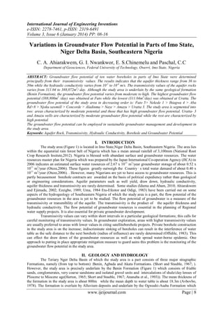
  • 6. Transmissivity (m²/day) Variations in Groundwater Flow Potential in Parts of Imo State, Niger Delta… 450,300 400,300 350,300 300,300 250,300 200,300 150,300 100,300 50,300 300 55.00 50.00 45.00 40.00 35.00 30.00 Transmissivity (m²/day) Aquifer thickness Figure 4. Variation of aquifer with aquifer thickness 450,000 400,000 350,000 300,000 250,000 200,000 150,000 100,000 50,000 0.1200 0.1000 0.0800 0.0600 0.0400 0.0200 0.0000 Hydraulic Conductivity (m/s) Figure 5. Variation of transmissivity with hydraulic conductivity Figure 6. Contour map of aquifer thickness of the wells www.ijeijournal.com Page | 13
  • 7. Variations in Groundwater Flow Potential in Parts of Imo State, Niger Delta… Fifure 7. Contour map of the hydraulic conductivity Table 1. Lithology and hydrological characteristics of groundwater in the studyarea LOCATI DEPT LITHOLO AQUI STATIC HYDRA Trasmissi ON H (m) GY FER WATER ULIC vity THIC TABLE CONDU (m2/day} KNE (m) CTIVITY SS (m/s) (m) Nekede 1 0 - Laterite 44.8 18.2 1o-1 387,072 4 Fine sand 4 - Sandy clay 10 Medium 10 -16 coarse sand 16 - 30 Very coarse sand gravel 30 - 40 GEOLOGIC5L FORMATION Benin Formation 40 -60 Aladinma 0 6 6– 10 10 20 20 40 - Laterite Fine sand Medium – Coarse sand Very coarse sand – Medium coarse sand Very coarse sand 50 30 10-3 4, 320 Benin Formation 40 - 60 60 -80 www.ijeijournal.com Page | 14
  • 8. Variations in Groundwater Flow Potential in Parts of Imo State, Niger Delta… Uratta 3 0–7 7- 12 12 - 24 24 – 36 36 – 50 Laterite Fine sand Very coarse sand Gravel Very coarse sand Medium coarse sand 36 54 10-4 311. 04 Laterite Silt Sandy clay 39 26 10-1 336,960 Benin Formation Laterite Fine sand Sandy clay Gravel Coarse sand Medium coarse sand Laterite Silt Medium coarse sand Very coarse sand gravel 38 22 10-3 3, 283.2 Benin Formation 45 15 10-1 388,800 Benin Formation Laterite Clay Sandy clay Medium 49 21 10-2 42, 336 Benin Formation 50- 90 Ihiagwa 4 Naze Futo 5 0 – 6.5 6.5-10 10- 15 15 – 35 35 – 65 0 -5 5- 15 15 -17 17 – 24 24 -30 30 -60 0 -4.0 4–8 8 – 16 18 -30 40 – 60 Njoku sawmill 0 -4 4- 6 6– 18 18-30 www.ijeijournal.com Page | 15
  • 9. Variations in Groundwater Flow Potential in Parts of Imo State, Niger Delta… 30 -60 Aba Rd. 8 Concorde 9 Amazu coarse sand Very coarse sand gravel 60- 70 03 Laterite 36 Sandy clay 46 Silt Medium 6 -30 coarse sand Very coarse sand 30 - 80 0–7 Laterite 7-10 Sandy clay 10 -40 Medium coarse sand Very coarse 40 -50 sand gravel 50 -70 0 – 15 15 – 20 20 -30 30 – 50 50 – 80 Laterite Sandy clay Fine sand Medium coarse sand Very coarse sand 50 30 10-2 43, 200 Benin Formation 40 30 10-2 34,560 Benin Formation 45 35 10-4 388.8 Benin Formation Table 2. Well classification based on transmissivity values TRANSMISSIVITY (m2/day) CLASSIFICATION OF WELL >500 High Potential 50 – 500 Moderate Potential 5 – 50 Low Potential 0.5 – 5 Very Low Potential <0.5Neglible Potential SOURCE: Offodile (1983} LOCATION Futo 5 Nekede 1 Ihiagwa 4 Aba Rd. 6 Njoku Sawmill Concorde Aladinma Naze Amazu Uratta 3 Table 3. Groundwater flow potential trend of the study area AQUIFER HYDRAULIC Transmissivity (m2/day) THICKNESS CONDUCTIVITY (m) (m/s) 45 10-1 388,800 44.8 10-1 387,072 39 10-1 336,960 50 10-2 43,200 49 10-2 42,336 40 10-2 34,560 50 10-3 4,320 38 10-4 3, 283.2 45 10-4 388.8 36 10-4 311.04 www.ijeijournal.com Groundwater flow potential High High High High High High High High Moderate Moderate Page | 16