1. 137
POTENTIAL USE OF INNOVATIVE DREDGE TECHNOLOGY AND BENEFICIAL
USE OF SEDIMENT FOR RIVER RESTORATION
John C. Marlin
Waste Management and Research Center, Illinois Department of Natural Resources,
One E. Hazelwood Drive, Champaign, Illinois 61820
E-mail: jmarlin@wmrc.uiuc.edu
During the past century sediment has filled over 70 percent of the volume of the Illinois
River backwaters and side channels. Areas that were once six to eight feet deep are now 18
inches or less at normal pool. Sedimentation’s dramatic adverse impact on recreational and
environmental resources has been well documented (see references below). The sediment has
essentially replaced a diverse benthic habitat with a flat, featureless layer of fine grained
sediment under shallow water. Additionally, since 1900 higher average water levels resulting
from the altered hydrologic regime have made it impossible for many native floodplain flora and
fauna to remain in their historic locations. Within a generation most of the 60,000 acres of
backwaters will be converted to willow covered mudflats if depth is not restored and sediment
input reduced.
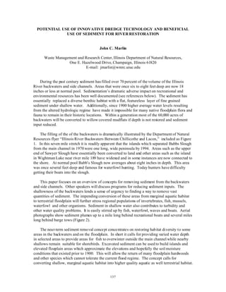
The filling of the of the backwaters is dramatically illustrated by the Department of Natural
Resources flyer “Illinois River Backwaters Between Chillicothe and Lacon,” included as Figure
1. In this seven mile stretch it is readily apparent that the islands which separated Babbs Slough
from the main channel in 1970 were one long, wide peninsula by 1994. Areas such as the upper
end of Sawyer Slough have essentially been converted to land and other areas such as the island
in Wightman Lake near river mile 189 have widened and in some instances are now connected to
the shore. At normal pool Babb’s Slough now averages about eight inches in depth. This area
was once several feet deep and famous for waterfowl hunting. Today hunters have difficulty
getting their boats into the slough.
This paper focuses on an overview of concepts for removing sediment from the backwaters
and side channels. Other speakers will discuss programs for reducing sediment inputs. The
shallowness of the backwaters lends a sense of urgency to finding a way to remove vast
quantities of sediment. The impending conversion of these areas from marginal aquatic habitat
to terrestrial floodplain will further stress regional populations of invertebrates, fish, mussels,
waterfowl and other organisms. Sediment in shallow water also contributes to turbidity and
other water quality problems. It is easily stirred up by fish, waterfowl, waves and boats. Aerial
photographs show sediment plumes up to a mile long behind recreational boats and several miles
long behind barge tows (Figure 2).
The near-term sediment removal concept concentrates on restoring habitat diversity to some
areas in the backwaters and on the floodplain. In short it calls for providing varied water depth
in selected areas to provide areas for fish to overwinter outside the main channel while nearby
shallows remain suitable for shorebirds. Excavated sediment can be used to build islands and
elevated flooplain areas which approximate the elevations and hopefully the soil moisture
conditions that existed prior to 1900. This will allow the return of many floodplain hardwoods
and other species which cannot tolerate the current flood regime. The concept calls for
converting shallow, marginal aquatic habitat into higher quality aquatic as well terrestrial habitat.
2. Babb’s Island
Route 17
Wightman Lake
Sawyer Slough
Babb’s Slough
Navigation Channel
Meadow Lake
RR Bridge
Lacon
DNR
Boat Ramp
RM 189
X
RM 187
X
RM 183
X
Illinois River Backwaters Between Chillicothe and Lacon
Above is a topographic map of the area in the photo below. It is based on
aerial photography taken in 1970. Note that Babb’s island was once much
narrower and there were two natural entrances to the sloughs from the
main channel between Lacon and River Mile 183. The composite photos
taken in 1994 show the loss of water surface in the backwaters during the
24 year period, especially at the North end of Sawyer slough and
Wightman Lake near the bridge.
The 60,000 acres of Illinois River backwaters have lost over 70% of their
capacity since 1900. Backwaters that were six to eight feet deep now
average less than 18 inches due to accumulated sediment.
The lakes and sloughs pictured here have lost much of their value to
fish, waterfowl, and other plants and animals. Even shallow draft
recreational boats frequently are unable to navigate these areas. The
public has a huge investment in these backwaters, many are currently
state and federal refuges. Unless depth is restored, these waters will
totally fill with sediment and be converted to willow-covered mudflats.
This map is a composite of aerial color infrared photographs taken by the U.S. Geological Survey in 1994. The
photos are available on the Web site of the Upper Midwwest Environmental Sciences Center in LaCrosse WI.
(http://www.umesc.usgs.gov/). Map compiled by the Waste Management and Research Center of the Illinois DNR.
N
3. 139
Figure 2. Fine grained sediment is easily resuspended, especially in shallow water. In this picture a suspended
sediment plume several mileslong is visible behind abarge tow in Upper Peoria Lake. Plumes of varyinglengths are
also generated byfish and recreational craft.
The alternative is to lose virtually all of the aquatic habitat outside the main channel.
Most of the accelerated sedimentation in Illinois River has occurred since the Lake Michigan
diversion began in 1900. Other dramatic changes over the century also impacted the river
hydrology including the navigation channel and dams, altered farm practices, stream
channelization, and urban runoff. Since the problem developed over a century, it is reasonable
to expect a restoration effort to take as long as twenty years. This would provide time to
remove, dewater, and find uses for sediment and allow funding to be appropriated over many
years. A large scale restoration could involve removing hundreds of millions of cubic yards of
sediment. In the Peoria area the sediment generally consists of fine grained silt and clay particles
with little sand. The sediment averages about 50 percent moisture content and is similar to
cookie dough in consistency. Figure 3 is a photo of a fresh sediment core.
TECHNOLOGY
River dredging to maintain Mississippi and Illinois navigation channels was historically
associated with environmental problems, because the dredged material was frequently placed in
backwaters and side channels. Conventional hydraulic dredges agitate the sediment, mix it with
water and discharge a slurry consisting mainly of water carrying five to fifteen percent sediment.
Today the slurry is usually pumped to a diked or bermed placement site where it settles and
gradually dewaters. Because it is mostly water it must be placed in a diked area and dried before
4. 140
Figure 3. Sediment cores up to nine feet in length show that the sediment is soft but relatively firm. As seen above a
fresh core keeps its shape and loseslittle water. If the sediment can maintain its in place consistencyduring
excavation, it will be much easier to build islands or dewater on shore for other uses.
it can be moved or put to most beneficial uses. An advantage of the hydraulic dredge is that it
can efficiently move the slurry for miles through relatively inexpensive pipelines. Disadvantages
include the need to manage large volumes of water, resuspension of contaminants and sediment
particles, and the total disruption of the structure and consistency of the in-place sediment. An
alternate technique that reduces the amount of water added to the sediment, maintains its
consistency, reduces resuspension would be desirable.
A number of high solids slurry pumps and similar devices exist which manufacturers claim
can pump material with 30 to 50 percent moisture content under suitable conditions (Figure 4).
A high solids pump could place material in a barge or on-shore holding area. Its advantage lies
in the greater amount of sediment contained in the slurry which decreases the required amount of
storage and bermed dewatering area. Such pumps could also be used to discharge sediment
directly from the river or from barges onto fields or containment areas.
Clam shell buckets on floating cranes are commonly used to dredge channels and boat slips.
They mix little water with sediment and can be used to directly build low islands such as those
built in 1994 in Upper Peoria Lake. Their primary limitation on a major restoration project is
the length of the boom. Material must be double handled if it is placed father than the crane can
reach.
DRE Technologies, Inc. of Nashville developed a new type of dredge which combines a
small clam shell bucket with a displacement pump. Their dredge takes bites of sediment without
5. 141
Figure 4. A number of companies make pumps which are capable of handling material with a high solids content. The
pumps are available in various sizes and can be mounted on conventional excavator arms or cranes.
adding water, drops it into a small hopper, and a displacement pump sends it through a pipe at
essentially in situ moisture content. The discharge is much thicker than that of a hydraulic
dredge (Figure 5).
Bucket wheel excavators on tracks have been used for many years in the mining industry and
for handling bulk materials. Engineers familiar with the design of these machines believe that
they can be modified to operate in shallow areas of Peoria Lake and other backwaters. They
would scoop sediment off the bottom and place it on a conveyor belt. Traction would be
provided by wide, low ground pressure tracks. Figure 6 is an excavator on conventional tracks.
Caterpillar Inc and at least one other company is investigating the use of a large diameter
excavating wheel mounted on a floating platform to remove sediment with very little
resuspension or added water. The concept is a high volume device that would bring sediment off
the bottom at essentially its natural consistency. A conveyor could be used to move the sediment
to a placement site.
Floating conveyor belts are used in several mining operations. Figure 7 shows a 2100 foot
floating conveyor operating in California. Several engineers have concluded that conveyors
could move Illinois River sediment for miles if necessary, provided it is not mixed with excessive
amounts water during excavation.
6. 142
Figure 5. The DRY DREdge (TM) by DRE , Inc. uses a small clamshell bucket and a displacement pump to remove
and transport sediment at essentially its in situ moisture content. The discharge aboveis about the consistency of
toothpaste. The current working modelhas a low capacity compared to conventional machines.
BENEFICIAL USE OF SEDIMENT
A comprehensive river restoration project could generate millions of cubic yards of dredged
material. DNR is looking into potential uses which will depend on the chemical constituents
and the cost of moving sediment. Some potential uses include: constructing islands and other
habitat, landscaping soil, strip mine and brownfield reclamation, construction fill and flowable
fill for construction. The Corps of Engineers Waterways Experiment Station is investigating
some of these uses.
DNR collected 900 pounds of sediment from the river bottom in April, 1999. It was dried
and used to grow five species of plants in pots at an Illinois Natural History Survey greenhouse.
Preliminary results indicate no noticeable difference in germination, wet weight and dry weight
of plants grown in sediment and Champaign County top soil. Peoria Lake sediment has been
successfully used by IDOT contractors to vegetate a new highway intersection. A University of
Illinois soil lab is evaluating soil formed by sediment placed in fields many years ago. The
texture, minerology, organic matter content and nutrients contained in sediment are similar to
that found in high quality topsoil. River sediment is initially quite hard, but after weathering
develops soil structure and much improved tilth.
Building new islands in the river or enlarging existing ones is a likely use of some sediment.
The islands would most likely be long and narrow to minimize the impact on flood heights and
7. 143
Figure 6. Conventional tracked wheel excavators are used in mining and materials handling situations. The machine
could be adapted with wider tacks and other features to operate in shallow water in Upper Peoria Lake. The excavator
discharges to a conveyor belt.
could be built high enough to provide habitat for a number of floodplain hardwood trees and
other native species that are unable to adapt to the current altered hydrologic conditions. They
would also reduce wind and wave action and provide safe nesting and resting areas for numerous
bird species. The large number of waterfowl using the two artificial islands in Upper Peoria
Lake provide evidence that this concept will prove useful to wildlife.
The Corps of Engineers built two small islands in Upper Peoria Lake as part of the
Environmental Management Program (Figure 8). In 1994 a clamshell dredge was used to place
sediment into two narrow islands in the lake about a mile long. The primary limitation on their
size was the distance the crane’s boom could reach. The first island consisted of the soft
material of the upper sediment layer and was expected to wash away. The larger island used
more consolidated sediment and sand from the original bottom. Both islands are still in place
and the larger one is covered with trees. Neither island has any rip rap or other shoreline
protection. The islands are viewed by many as prototypes for the design of future islands.
Large new islands up to several hundred feet wide could be developed using a number of
techniques. A conventional or high solids dredge could pump sediment into an island shaped
containment area built with a clamshell or other device. It would take a relatively long time for
these sediment to dewater and consolidate.
Another option would use a conventional floating crane and clamshell in combination with a
conveyor to overcome the short reach limitation of the clamshell (Figure 9). The conveyor could
8. 144
Figure 7. This 2100 foot floating conveyor belt is operated by CalMat, Inc. at Irvine Lake in California. Conveyors
could be used to move excavated Illinois river sediment at in situ moisture content. Like pipelines, conveyors could
move sediment over several miles to a shore facility or to build islands. They are more expensive than pipelines.
effectively extend the reach of the crane for miles if desired. This would allow sediment with
relatively low moisture content and some of its initial consistency to be conveyed intact to an
island under construction. It would decrease the amount of time needed for the material to
consolidate. The island’s height above normal pool could be increased by adding lifts as the
sediment dries. If one of the excavator concepts proves feasible, such construction could
become even more efficient. The conveyor could also transport sediment for land placement.
If it is necessary to protect new islands from the erosive force of waves, a number of
methods could be employed including rip rap and geotextile tubes. These tubes can be 30 feet
in circumference and hundreds of feet in length. When pumped full of sediment they are quite
firm and can perform like an erosion proof berm. In coastal areas such tubes are used to develop
wetlands and protect beaches and diked areas (Figure 10). The Fox Waterway Agency in
Northern Illinois placed a geotextile tube as a breakwater several years ago that is still
performing well. They are currently in the process of constructing an island using about 6,000
linear feet of tubes. The tubes may also prove useful to break up wave and wind fetch in
wildlife areas such as Lake Senachwine.
Huge amounts of sediment could be pumped or conveyed to areas on shore and stockpiled
until used for landscaping soil, fill or other purposes. It is possible that it may be built into large
mounds and planted with trees or grasses until needed. Large mounds built in southern Illinois
by Native Americans consist of sediment and provide examples of the potential durability of
such stockpiles.
9. 145
Figure 8. The two long, narrow islands in the foreground were constructed by the Corps of Engineers in 1994 aspart
of the Environmental Management Program. They are still in good shape after withstandingfive yearsof waves and
weathering without riprap or other protection. The islands areused extensivelyby numerous species, especiallybirds.
They also break up wind fetch and reduce the adverseeffect of waves.
The Peoria Lakes and other backwaters could be deepened by using of the technologies
discussed above. For the most part the techniques have existed for some time, but have not been
commonly used in combination or for environmental habitat restoration. It is likely that several
techniques will be used in any restoration project given the varying conditions in the river valley.
Judicious dredging could preserve the areas as aquatic habitat until erosion control methods have
time to reduce the sediment inputs and society decides the long term future of the river corridor.
REFERENCES
Bellrose, F.C., S. P. Havera, F. L. Paveglio, and D. W. Steffeck. 1983. The Fate of Lakes in
the Illinois River Valley. Illinois Natural History Survey. Biological Notes No. 119. 27pp.
Champaign, Il.
Demissie, M. and N. G. Bhowmik. 1986. Peoria Lake Sediment Investigation. Illinois State
Water Survey, Contract Report, 371. 88pp. Champaign, Il.
Demissie, M., L. Keefer, and R. Xia. 1992. Erosion and Sedimentation in the Illinois River
Basin. ILENR/RE-WR-92/104. Illinois Department of Energy and Natural Resources.
Springfield, Il.
10. 146
Figure 9. A conventional clam shell bucketon a floating cranebuilt the islands in Figure 8. Its
main limitation was that material could not be excavated over an area larger than the crane could
reach and still depositmaterial on the island. By using a conveyor belt in combination with a
crane, sediment could be moved long distances from the excavation point and used to build islands,
be placed on shore or in barges. Floating conveyors could extend several miles.
Demissie, M. 1997. Patterns of Erosion and Sedimentation in the Illinois River Basin. In
Proceedings of the 1997 Governor’s Conference on the Management of the Illinois River
System, pp. 69–78.
Environmental Studies Work Team. 1981. Technical Report D, Environmental Report,
Comprehensive Master Plan for the Management of the Upper Mississippi River System.
Upper Mississippi River Basin Commission. Minneapolis.
Mills, H. B., W.C. Starrett, and F. C. Bellrose. 1966. Man’s Effect on the Fish and Wildlife of
the Illinois River. Illinois Natural History Survey Biological Notes 57. 24pp.
Talkington, L. 1991. The Illinois River: Working for Our State. Illinois State Water Survey.
Misc. Pub. 128. Champaign, Il.
11. 147
Figure 10. Geotextile tubes filled with sand and sediment are becoming increasingly popular in water resource
applications. They can be used in place of riprap to protect shorelines and are capable of supporting vegetation. Tubes
could be used in shallow water to break up waves. They could serve numerous functions in an Illinois River
Restoration Project including protecting islands from the erosive force of waves generated wind and vessels.