Indigenous Land Management - Emilie-Jane Ens & Gill Towler
•Transferir como PPT, PDF•
2 gostaram•824 visualizações

TERN Symposium 2011

Recomendados
Recomendados
Mais conteúdo relacionado
Mais procurados
Mais procurados (20)
Destaque
Destaque (12)
Semelhante a Indigenous Land Management - Emilie-Jane Ens & Gill Towler
Semelhante a Indigenous Land Management - Emilie-Jane Ens & Gill Towler (20)
Mais de TERN Australia
Mais de TERN Australia (20)
Último
Último (20)
Indigenous Land Management - Emilie-Jane Ens & Gill Towler
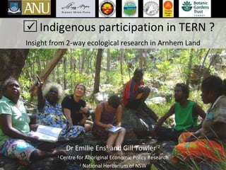
- 1. Indigenous participation in TERN ? Insight from 2-way ecological research in Arnhem Land Dr Emilie Ens 1 and Gill Towler 2 1 Centre for Aboriginal Economic Policy Research 2 National Herbarium of NSW
- 2. Indigenous estate and land use agreements
- 3. Relationship between the Indigenous estate and the conservation estate From Altman 2006
- 4. Residual Eucalypt woodland Woinarski et al. 2007
- 8. Participatory research in Arnhem Land
- 9. 35 long term monitoring sites Arnhem Land Kakadu NP Maningrida Jabiru Ngukurr Yirrkala Kabulwarnamyo
- 10. Innovative software: CyberTracker
- 11. Example 1: Feral animal impacts
- 12. Example 2: Wetland condition
- 13. Example 3: Flora inventory
Notas do Editor
- Good afternoon everyone, I just wanted to start by acknowledging the Traditional owners of this country, the Wurundjeri mob, I would also like to pay respect to the elders past and present of the kulin nation and extend that respect to other Indigenous Australians present. Today I will briefly talk about how important it is to incorporate Indigenous Australians into a national initiative like TERN which aims to conduct long term biodiversity monitoring across Australia. There are a few key points I want to make about why it is necessary to foster Indigenous participation . There are plenty of successful projects up and running which we can draw on, as highlighted at last years ESA conference. The first is that currently, Indigenous Australians currently own 23% of Australia’s land mass, most of this in the Rangelands, and this figure is likely to increase with more native title declarations The indigenous estate presents some of the most intact and biodiverse regions of remotely Australia There is already substantial effort to monitor biodiversity on the ground, using both indigenous and non-Indigenous methods – with the potential for a lot more!
- Since the introduction of the government policy of self determination and the land rights legislation of 1976, significant tracts of country have been returned to the first custodians. Currently, 23% under native title or other land rights legislation - as shown by the orange areas on this map, And around 40-50%? If we include ILUA’s, as shown in green Of note is that most of these Indigenous managed areas are in very remote parts of Australia and where there are high densities of Indigenous communities. So from this map it is clear that a significant portion of the Rangelands are owned and managed (at least in part) by Indigenous people.
- This schematic shows the significance of the Indigenous estate (in red) compared to the National reserve system (green number 3). It also shows that in 2006 IPAs made up 23% of the NRS. And this figure is set to increase. So these diagrams clearly illustrate that Indigenous people and Indigenous land management have a lot to contribute to Australian national biodiversity and conservation objectives in terms of area of land managed.
- Furthermore, the Indigenous estate covers some of the most intact and biodiverse ecosystems in Australia, as shown by this map of residual, modified and replaced Euc woodland. However we also acknowledge that like the rest of the country, there are significant environmental threats to the integrity of this country. This is why Indigenous people generally are keen to work with non-indigenous scientists to understand these threats and use a combination of both Indigenous and western knowledge systems and techniques to effectively manage their country.
- So, how is indigenous land management different to western concepts? Indigenous people talk about caring for or looking after country...For Aboriginal people country means more than it does to us as non-indigenous people. Deborah Bird-Rose, prize winning author of Indigenous philosophy, life and culture informs us that Country in Aboriginal English is not a common noun, but a proper noun. People talk of country like they talk about a person: they speak to country, sing to country, visit country, worry about country, feel sorry for country, and long for country. So Country for Aboriginal people is multidimensional – it consists of people, animals, plants, spirituality, Dreamings, earth, soil, minerals, water, and air and the interactions between. Indigenous people hold a holistic and interconnected view of the land and its people which is reflected in the Indigenous worldview, values, history and living culture. For many Indigenous people, Management of natural resources is essential for life and wellbeing It is their Customary responsibility and Aboriginal people have been doing this “caring for country” for millenia through tried and tested methods – Indigenous science.
- There has been a ground swell of interest in this area and there is increasing support for community based NRM from a range of agencies.
- Because of these funding arrangements a range of data are being collected for different reasons and at different levels, scales and with differing involvement of indigenous people. For example, turtle sightings, large scale fire monitoring and localised water quality testing. Three main types…
- Now we just wanted to show you a few a ways that we are working with traditional owners in Arnhem land to collect baseline biodiversity data and establish long term monitoring projects.
- Considering the low literacy and numeracy of most indig rangers, we have used the Cybertracker software that was developed in Africa to assist the african bushmen with the documentation of their animal tracking work. This software allows you to develop purpose specific “sequenes” which are basically a set of questions that the user would answer. The questions can be in the form of words, images or icons. We have developed our cybertracker sequences through workshops with Indige rangers to collect data on feral animal damage. Through the workshops the rangers identified indicators of damage and good country. Here on the screen I have included a screen shot of the cybertracker computer interface. This where we build up the data recording sequence. This example is the monitoring sequence used by the yirralka rangers’. It was important for them to use Yolngu language and these words were supplemented with images to assist with word recognition. The sequences are uploaded onto a hand held computer. To monitor the health of the country we collect data along 3 transects at each of the monitoring sites. Three sets of questions related to the ground features are answered at each step, effectively each metre, along the 100m transects. After the days data collection the data is easily downloaded to the mothership computer, which removes the need for writing and data entry. The data collection is repeated in the early and late dry seasons, over a number of years. This information is then graphed which allows visual comparison of the health of different sites and also temporal variation throughout the year and across years.
- Photo points Measuring ground surface and cover features along 100m transects
- Water quality testing and algae surveys
- Collecting, pressing, identification using western botanical and Indigenous language - making local herbaria and e-herbaria - recording Indigenous knowledge about plants using video - facilitating Indigenous exchange at Sydney and Canberra herbaria to further identify plants and train Rangers in western botany and potentially add Indigenous names and uses to national databases
- There is a lot of untapped knowledge out there that could be incorporated in to TERN and built on with more research and collaborations