
Recomendados
Mais conteúdo relacionado
Mais procurados
Destaque
Semelhante a The SCM #004
Semelhante a The SCM #004 (18)
Último
Último (20)
The SCM #004
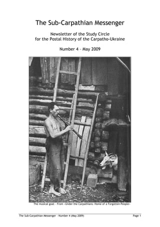
- 1. The Sub-Carpathian Messenger Newsletter of the Study Circle for the Postal History of the Carpatho-Ukraine Number 4 – May 2009 The musical goat – From »Under the Carpathians: Home of a Forgotten People« The Sub-Carpathian Messenger – Number 4 (May 2009) Page 1
- 2. About the title page Excerpt from the chapter A Hard Life Indeed, for all the progress which the country has made in recent years, superstition is still rampant in the remote villages. Doctors’ pills and concoctions may be good for „foreign- ers” but a true uplander does not readily believe in them. When he falls ill – and it must be a real illness, for these peasants do not make much fuss – he prefers to call on the local witch, who may put a piece of snake skin on the ailing part of his body and recite a few magic words which are sure to put him on his feet again. If he does not get better then he has probably chosen the wrong witch, for there are good and bad witches. And one never knows what a bad witch may do. She may creep up to a cottage by night and put a spell on the goat, with the result that the goat stops giving milk. This is a serious thing, particularly if the cottager has only one goat; so, if it happens, something has to be done. The pea- sants have learned in the course of time how to meet the emergency and know the anti- dote to the evil spell. A tune played on the flute in the evening is, so they say, an unfailing cure. J. B. Heisler, J. E. Mellon: »Under the Carpathians: Home of a Forgotten People« (London, 1946) About us and the Newsletter The Study Circle is a loose group of persons who are interested in the postal (and general) history of the area known as Kárpátalja in Hungarian, as Podkarpatská Rus during the First Czechoslovak Republic, which had a short day of independence as Carpatho Ukraine, and later was integrated into the Ukrainian SSR in the Soviet Union as the ‘Zakarpatskaja Ob- last’. Since 1991 it is the westernmost administrative district in the Ukraine. The Newsletter came out of a meeting of a few collectors during the PRAHA 2008, its first number appeared in November 2008. Since then it has been growing steadily. We aim to produce between four and six numbers per year (if input allows) but do not promise regu- lar publication intervals. At the moment our Newsletter goes to about 30 interested persons, mostly by e-mail, to a few (who have no e-mail access or have tight size limits on their input boxes) as a colour print-out by classical mail. The Newsletter is sent as a PDF file and has about 6 megabytes in transfer. In the near future we may switch to a system where the Newsletter(s) can be downloaded from a particular public website. Our warm welcome to Dr. Cristian CAMARTIN (Switzerland). All articles in the Newsletter carrying the name of an author are the sole responsibility of this author and should not be taken to represent the common opinion of the Study Circle. Such articles are, if not marked otherwise, copyrighted by the respective author. Free use within the Study Circle is granted. Participation in the Study Circle is not bound to a formal membership and does not include the duty to pay a membership fee. There is a moral obligation to support the Newsletter from time to time by sending some article, some interesting piece of information, some question, some answer or whatever. We will “print” everything even only loosely connected with our subject of interest so any contribution is certainly welcome. Please send it (as a Word 2000 document, graphical elements in JPEG, 300 dpi) to our editor’s e-mail address (kb@aatc.at). His postal address, if you would need it, is: Dr. Helmut Kobelbauer Untergrossau 81, A-8261 Sinabelkirchen, Austria / Europe The Sub-Carpathian Messenger – Number 4 (May 2009) Page 2
- 3. Jan Verleg and Tønnes Ore Auction News In Ji í Majer's auction on 7 March, some remarkable Carpatho- Ukraine items were sold. Lot 861 was described as a black proof on transparent paper of the 60 [f] of the first definitive issue of the NRZU in the year 1945. The lot was sold for CZK 5000 (about 180 Euro). Note that the “6” has a distinctively different shape compared to the “6” of the regular issue. It is probably a proof of a rejected design of this denomination. Lots 862-4 are also worth mentioning: Two trial prints of the 100 [f] and one of the 200 [f]. They were sold for CZK 4200, 4200, and 3200, respectively. Lot 1033 was a money order for a C.O.D. con- signment sent from Chust to Prague on 15 March, 1939 – the date makes it very special. It was sold for 18,500 CZK (about 670 Euro). For cancelling it the regular date stamp of Chust was used, but with the letter “a” instead of the “d” stamp used for the cancellation of the commemorative 3K stamp. It is hard to figure out the hour because of the very faint im- pression – a good guess might be 11. In Richard Burda's auction on 28 March, another interesting item from 15 March, 1939 was offered: An underfranked letter with a 20 h. Czech stamp, cancelled with the red special postmark from Chust. Apparently it went through the mail to Jihlava, where it was charged 20 h. postage due on 25 March. It was sold for CZK 12,500. A wide range of philatelic covers with the commemo- rative 3K stamp were also offered, including a blank one with date 2. III 39, and with the signature of Augustin Voloshin, sold for CZK 6200. In the same auction, an essay in black and white for the 3K stamp was sold for CZK 9200. The Sub-Carpathian Messenger – Number 4 (May 2009) Page 3
- 4. Tønnes Ore Maps of Carpatho-Ukraine I have always loved maps, and Helmut's detective story about Luh / Tiszalonka in the SCM #003 inspired me to compile this short survey of maps of Carpatho-Ukraine. I am not a map collector (who can afford to collect both maps and postal history?), but I have a few, and I have downloaded almost every map related to Carpatho-Ukraine that I have been able to find on the Internet. To start with the historical maps: Hungary has a long cartographic history, and the first maps that show anything of interest of Carpatho-Ukraine were made in the 16th century. On this and the following pages I show scanned details from facsimile versions of two old maps, one from 1579 and one from 1686. It is interesting to note which of the towns / villages in our area were considered important enough to be shown on the map. Map of Hungary, dated 1579 Detail of the map above, showing Carpatho-Ukraine The Sub-Carpathian Messenger – Number 4 (May 2009) Page 4
- 5. Maps from the 18th century can be very useful for a postal historian, because they show the postal roads and postal stations. I have several maps in a series published in the late 18th century, of which one shows parts of Carpatho-Ukraine. If you are interested in finding historical maps on the Internet, a good place to start seems to be www.topomap.hu/oszk/hun/terkepek.htm. The site has a large number of scanned historical maps, starting with the 1500s. But view- ing is a bit awkward. Different options are offered, but they are not very easy to use. You can magnify the maps, but then you get only a small section. www.topomap.hu is the website of the Hungarian Ministry of Defence Mapping Company. They sell facsimiles of historical maps – choose the English version (if you are not fluent in Hungarian), click on the historical map, choose 'Historical Facsimile maps', and you get a list with illustrations and prices in Euro. Map of Hungary, dated 1686 The Sub-Carpathian Messenger – Number 4 (May 2009) Page 5
- 6. Detail of the map on the previous page (1686), showing Carpatho-Ukraine Map of eastern Hungary from late 18th century, showing postal routes The Sub-Carpathian Messenger – Number 4 (May 2009) Page 6
- 7. Detail of map on previous page, showing parts of Carpatho-Ukraine Now to the more recent "historical" maps. Helmut has mentioned the Austro-Hungarian mi- litary maps from 1910 in 1:200 000, which can be found at lazarus.elte.hu/hun/digkonyv/topo/3felmeres.htm . Every single sheet is there, with an easy-to-use, "clickable" index map. The maps can also be found in a number of other sites, including digitalgallery.nypl.org/nypldigital/dgkeysearchresult.cfm?keyword=spezialkarte , but lazarus.elte.hu seems to be the best site. Another valuable source of information is a set of Hungarian county (=Komitat =vármegye) maps that were printed around 1910 in the scale 1:500 000. Of course they contain much less information than the 1:200 000 maps, but they are easier to use. They can be found at lazarus.elte.hu/hun/maps/1910/vmlista.htm . I would also like to mention one useful paper map, although it is not really "historical": Kárpátalja m emlékei (Ca-U Monuments) 1:300 000, printed in Budapest 1990. It has both Ukrainian and Hungarian names for all villages, and all historical buildings shown by special symbols. A similar map can be found at www.karpataljaturizmus.info (low resolution!). From sheet 42-48 in the 1:200 000 series of 1910 From the county map of Máramaros, 1912 (enlarged) The Sub-Carpathian Messenger – Number 4 (May 2009) Page 7
- 8. From the map 'Kárpátalja m emlékei', 1990 From map on www.karpataljaturizmus.info Map databases on the Internet maps.vlasenko.net seems to be the website for Ukrainian maps. It is in Ukrainian only, but easy to use even if you don't know the language. It is not immediately apparent who is running the site or whether it has "official" support or not. But it is interesting to observe that until very recently the maps seemed to be stored in a data base at the University of California at Berkeley. But the site has it all: Online browsing of maps with a clickable index map, and also the possibility of looking at (or download) any single sheet in several series of maps: 1:100 000, 200 000, 500 000, 1 000 000. Just click on a rectangle in the index map, and the sheet pops up (most of them in .jpg format, some in .bmp – ready to be stored on your computer). These maps are of military origin, and were probably printed in the 1970s. From sheet L-35-01 in the military 1:200 000 series From sheet 'Zakarpatskaya1', 1:200 000, 2006 New, revised maps published in 2006 are also available on the site – both in 1:100 000 and 1:200 000. For the 1:100 000 maps (in fairly large sheets) there is no index, except for a list sorted by sheet number. The relevant sheet numbers are: 125, 144, 145, 163, 164, 165, 182, 183, 184, 203, 204. The revised 1:200 000 series for Carpatho-Ukraine consists of just two very large sheets – Zakarpatskaya1 and Zakarpatskaya2. It can be seen that built-up areas and roads have been revised in the 2006 issues. In the 1:200 000 maps the spelling of place names has been changed from Russian to Ukrainian (e.g. ), but quite surprisingly, this has not been done in the 1:100 000 maps (the spelling is still ). The reasons for this must have been technical/economical. But there is even more: Follow the link 'Soviet military topographic maps of Russia, Europe unsorted (1:50 000)', and you will get access to wonderful, detailed maps in 1:50 000 – also of military origin, and printed in the 1970s. There are a few challenges, however: The The Sub-Carpathian Messenger – Number 4 (May 2009) Page 8
- 9. From sheet L-35-001 in the military 1:100 000 series From sheet 203 in the 1:100 000 series of 2006 The Sub-Carpathian Messenger – Number 4 (May 2009) Page 9
- 10. M-34 -106 M-34 -30 M-34 M-34 M-34 M-34 -117 -118 -119 -120 M-34 M-34 M-34 M-34 M-35 -129 -130 -131 -132 -121 M-34 M-34 M-35 -35 -36 -31 M-34 M-34 M-34 M-34 M-35 M-35 -141 -142 -143 -144 -133 -134 L-34 L-34 L-34 L-35 L-35 -010 -011 -012 -001 -002 L-34 L-34 L-35 -05 -06 -01 -3 -4 Above: Available sheets of the 1:200 000 -2 -1 -2 -1 military maps. -4 -3 -4 -3 -4 -3 Top right: Available sheets of the 1:100 000 military maps. -1 -2 -1 -2 -1 -2 Right: Available sheets of the 1:50 000 -3 -4 -3 -4 -3 -4 military maps. -1 -2 -1 -1 No maps are available for the shaded areas. -3 -4 -1 -2 -1 From sheet L-35-001-1 in the 1:50 000 series The Sub-Carpathian Messenger – Number 4 (May 2009) Page 10
- 11. index map is almost useless, as it covers most of Europe and Asia, and the "squares" are less than a millimeter across. The best way to find a map is to just click somewhere, get a sheet, and then change the address field in your web browser by filling in the correct sheet reference. How to find the sheet reference? The numbering is the same as for the 1970s 1:100 000 series, but with the addition of -1, -2, -3, -4 for the four quarter sheets (upper left, upper right, lower left, lower right). Some of the sheets of the 1:50 000 for Carpatho- Ukraine are not present, and some scans are incomplete. www.karpaty.com.ua/?chapter=maps has a clickable index map which allows you to look at or download sheets of the 1:100 000 map series from the 70s. The main site www.karpaty.com.ua also has lots of interesting information about Carpa- tho-Ukraine, but only in Ukrainian. www.infoukes.com/ua-maps/oblasts/oblast01/ is a website which announces itself as the 'Zakarpatska Oblast Map Server'. A clickable index map gives you maps in relatively small pieces. They seem to be based on older 1:200 000 maps (non-military). www.personal.ceu.hu/students/97/Roman_Zakharii/maps.htm : If you need road maps of the Ukraine, you can find them here. But they come in small pieces, and are not very detailed. From military map, 1:500 000 (enlarged) From military map, 1:1 000 000 (enlarged) From older map series, 1:200 000 From road map of Ukraine ('Zakarpatska Oblast Map Server') The Sub-Carpathian Messenger – Number 4 (May 2009) Page 11
- 12. A survey of Internet maps would not be complete without mentioning the map services which offer searching for place names. Some of them are surprisingly good: MSN Encarta: The full address is encarta.msn.com/encnet/features/MapCenter/Map.aspx – but you may find it easier to type encarta.msn.com and choose 'Atlas'. This service is offered by the joint venture Microsoft-NBC, and offers maps of the entire world, with a very good search function for place names. For many places it stores several alternative spellings (like Warsaw and Warszawa), so that you will get a match even if you use a different version from the one used on the map. It will also suggest alternatives which look or sound similar to the name you typed in. A search for 'Warschau' will (obvi- ously) not give an exact match, but 'Warsaw' will be in the result list because it is similar. An example from Carpatho-Ukraine shows that it is not quite perfect: 'Rakhov' is the spell- ing used in the atlas. A search for 'Rakhiv' gives the right match, and so does 'Rachov', but 'Rachiv' gives Rachiv in Tajikistan and no other suggestions. The maps are quite good (traditional geographic maps showing some topography) and can be zoomed, but they are not very detailed, so you will not find the very small places. The Luh close to poor Rudolph's cottage is not on the map. A search for 'Luh' gives several matches, but not Luh on the Tisa. One of the matches, in fact, is a 'Lug' in Zakarpattya, but placed in the exact position of Volosianka. Lug/Luh has apparently been used at some time as an alternative name for Volosianka (see below). Multimap ( www.multimap.com ) is another searchable atlas, with maps with the appear- ance of typical road maps. You have to specify the country before searching. The bad news is that the maps of Ukraine are totally void, except for some major highways and a few place names. But the search function still works very well! Place name spellings seem to be modern Ukrainian, but the search results are almost exactly the same as for Encarta. But a positive surprise is that 'Luh' finds Luh on the Tisa (as well as the Volosianka Luh). When you find Luh, it appears as circle in an otherwise blank map. But lo and behold – the next great surprise is about to appear: Switch to 'Aerial' instead of 'Map', and a beautiful, detailed satellite photo of the area around Luh materializes! Place name data bases: I agree with Helmut that the 'Lelkes' dictionary is the ultimate tool, but there are some useful databases of place names on the Internet. One that I found recently is sebok2.adatbank.transindex.ro (only in Hungarian) – it is obviously not on the 'Lelkes' level, but seems to be fairly complete. Enter 'Tiszalonka' or 'Lonka', and you will find Luh! Enter 'Luh', and you will get a reference to Volosianka. Used with care, the Internet is an infinite source of information. The Sub-Carpathian Messenger – Number 4 (May 2009) Page 12
- 13. Map from MSN Encarta, after search for ‘Rachov’ Satellite image from Multimap, after search for ‘Luh’ The Sub-Carpathian Messenger – Number 4 (May 2009) Page 13
- 14. Helmut Kobelbauer Ballonpost Przemysl 1915 A Few Additions and Remarks The following excerpt (including the reproduced picture) is from Dr. Simády Bela’s book »Kárpátalja Postatörténete« (page 46): Kárpátalja postatörténetének egyik legérdekesebb darabja a przemysli ballonposta Turjaremetén landolt léggömbjéb l származó tábori postai levelez lap: Az orosz csapatok által körülzárt és ostromolt Przemysl-ben 1915. március 7-én felbocsátott ballont Turjaremetén találták meg, és postáját március 19-én bélyegezte le a 47. számú tábori postahivatal /K.u.K. Feldpostamt/. Tudjuk tehát, hogy ebben az id szakban a 47. számú Feldpostamt Turjaremetén ködött. My Hungarian friend Dipl.Ing. Nagy Gábor has kindly translated this description for me: „One of the most interesting pieces of the postal history of the Kárpátalja is a field post card originating from the Przemysl balloon mail from a balloon which landed at Turja- remete: [The picture] From Przemysl, encircled and besieged by Russian troops, a balloon was released on the 7th of March 1915 and its mail was found at Turjaremete and postmarked by the field post office No. 47 on the 19th of March. We know for this reason that in this period the „Feldpostamt” No. 47 was in operation at Turjaremete.” This piece is, of course, also included in Jan Verleg’s monography of Carpatho Ukraine and is there accompanied by the following text (loc. cit., page 47): One of the most interesting post historical items originating from Carpatho Ukraine is a field postcard sent by balloon from Przemysl. The Russian army had encircled this village and the Hungarians within the encircled area used a balloon to send mail. The balloon was launched on the 7th March 1915 and landed in Turjaremete. The mail which could be re- covered was cancelled by K.u.K. Feldpostamt 47 on the 19th March 1915. This also proves Fieldpost office 47 was based in Turjaremete. On the card the large mark Zensuriert is German for censored. Also the German mark Zur Beförderung geeignet is written, which is more or less approval by the censor and means suitable for forwarding on . The Sub-Carpathian Messenger – Number 4 (May 2009) Page 14
- 15. Although this „Feldpostkorrespondenzkarte” is shown in his book, it is rather probable that Dr. Simády never was the owner of this interesting item. At least it was not part of his ex- hibition object (which won International Gold a few times) nor was it included in the col- lection as it was sold after his death. (This is the reason why the picture is only black and white – we don’t have access to the original.) We see that the translation provided for Jan and which was the starting point for his work is basically following the Hungarian text, with a few misleading add-ons (e.g. Przemy l was NOT a village – in 1900 it had already 46,295 inhabitants [Webersik 1908, p. 680] and was one of the major fortresses of the Austro-Hungarian monarchy). The story of the fortress Przemy l and its two sieges during WWI has been told in a number of books and booklets. In the »Austro-Hungarian APO’s 1914 - 1918« of Keith Tranmer one can find (page 52): „Three more balloons were released on the 7th of March [1915] and one was found at Turja-Remete in Hungary on the 19th March. The mail from this balloon was passed to FPO 47 who postmarked it.” In 2003 the Austrian „Arge Militaria Austriaca Philatelia” in Vienna published (in English) a brochure by Keith Tranmer with the title »PRZEMYSL 1914 – 1915«. From pages 93 to 95 we can learn a bit more of these curious trials to send mail out from the besieged fortress. His account in turn is based on the report of Oberst Nimmerrichter, given in the »Donaupost« in 1929. The use of free balloons was the idea of Oberleutnant Schlegl; the background was to re- lieve the pilots provided the wind was favourable. The balloon mail was unofficial, a pro- ject of four officers (Schlegl, Nimmerrichter, Schneider and Dietzius – a photograph is shown on the next page). The balloons were made of paper and as light as possible. Each balloon had to travel about 120 km over the front, the Russian lines and occupied territory. The Carpathians had to be crossed if a north wind prevailed, taking five to six hours. Each balloon carried a weight of mail of two kilograms comprising the lightweight cards, 500 per flight wrapped in balloon material to waterproof it. With the mail pack was a credit note for 10 Kronen for finding and handing over the mail to the authorities. The balloons were sent up ten at a time using the names of commanding officers to identify them. Unfortu- nately [Keith was writing] Nimmerrichter did not provide any dates but F.P.O. 47 cleared some mail flown in March on the 19th March found in Hungary, as did the Post Office in Lemes (May 18th, 1915) and Margitfalva (June 20th, 1915). The collection of Gerhard Schenk states that 10,000 cards were printed of which 6000 were sold, the highest numerator being 5909. Apparently 5 balloons were released on the 20th January [1915], and balloons 6 to 8 on the 7th of March, each carrying 500 (or 600) of the balloon cards. So the first thing we learn is that the thick „4840” on the upper left part of the pictured card is the numerator. The handwritten „Zur Beförderung / geeignet” (in the middle below the text „Feldpostkorrespondenzkarte“) was certainly added in Przemy l, as was the signa- ture to the right of it. Also the red one-liner „ZENSURIERT.” was a mark from Przemy l. Gerhard Schenk, the most prominent collector of Przemy l air and balloon mail in Austria, has written a book »Przemysl 1914 – 1915. Monographie über ein historisches Ereignis« him- self (published in 2003, too, by Verlag Pollischansky, Vienna). Its pages 142 to 147 help to understand some further details; on page 145 he writes: „Von einem weiteren Ballon ist der Abflug für den 7. März 1915 anzunehmen. Dieser wurde in Ungarn bei Turja-Remete aufgefunden und die Post beim FPA 47 (damals in Krakau stationiert) am 19. 3. 1915 abge- The Sub-Carpathian Messenger – Number 4 (May 2009) Page 15
- 16. stempelt.“ [Translated: For another balloon one has to assume that it was launched on March 7th, 1915. This balloon was found in Hungary near Turja-Remete and the mail was postmarked at the Field Post Office 47 (which at this time was located in Cracow) on the 19th of March 1915.] From Keith Tranmer’s brochure, page 95 So the conclusion of Dr. Simády that the FPO 47 at this time (March 1915) was in Turja- remete is wrong – the found mail pack was passed on by the finder(s) to the authorities which sent the pack to Cracow where the cards were postmarked on March 19th, 1915, and forwarded to the recipients. For him it was obviously quite difficult to find out whether some given FPO was located in the area he was interested in. So it is still – but now for us. The Sub-Carpathian Messenger – Number 4 (May 2009) Page 16