1. New Concepts in Global Tectonics Journal, V. 4, No. 4, December 2016, p. 615-636 www.ncgt.org
Late Permian coal formation under boreal conditions along the shores of the
Mongol-Transbaikalian seaway
Per Michaelsen
Department for Management of Science and Technology Development, Faculty of Environment and Labour
Safety, Ton Duc Thang University, Ho Chi Minh City, Vietnam
per.michaelsen@tdt.edu.vn
Abstract: Epicontinental seaways are almost absent from Earth today, but played an important role during
Paleozoic and Mesozoic times in terms of providing the depositional dynamics for accumulation of significant
economical deposits of coal and hydrocarbons. This study focuses on the coal-bearing middle part of a c.
2,600m thick Permo-Triassic succession developed along the southern shores of the Mongolian
Transbaikalian boreal seaway. The sedimentary sequences from this seaway are sporadically exposed over c.
900 x 150km in central and NE Mongolia.
The pan global Permian coal measures are unique in the evolution of the Earth, not matched in any period
before or since. In Mongolia, the Permian system is widely distributed and has global significance as it
contains two separate marine basins which were located in different climatic settings.
The study area is located in the Bayanjargalant district in central Mongolia and draws on a new integrated
database encompassing 38 drillholes (with a composite length of 2.600m), almost 3km of shallow
trenching, extensive field work, petrological analysis of sandstone samples and the results from 82 coal quality
samples.
The sedimentary record strongly indicates that the c. 420m thick Late Permian coal measures developed
along the shores of a relatively shallow boreal seaway during frequent sea-level changes. Eight
transgressive–regressive cycles characterized by the inter-digitation of paralic–shallow marine and coal-
bearing alluvial facies, are recognized from the stratigraphic record. These cycles are considered to represent
405ky Milankovitch eccentricity cycles of the Permian Period.
The immature nature of the framework grains in fluvial and shallow marine sandstones, coupled with the
significant thickness of the Permian succession, suggest relatively rapid sediment aggradation.
An 8-12cm thick shellbed is preserved at the base of the coal measures. The shell bed is dominated by cold-
resistant relatively robust archaeogastropods and taxodont bivalve taxa with subordinate brachiopods and
rare fragmented connulariids. The thickest coal seam (up to 12.8m) is developed above the shellbed,
probably during a major regressive event with sufficient time for peat-forming plants to colonize the
exposed seaway deposits and aggrade significant tracts of peat (possibly +100m in places).
Paleoclimatic indicators within the study area include; (1) glendonites; (2) strongly developed annual growth
rings in fragmented petrified tree trunks; and (3) rare ice-rafted debris. These paleoclimatic indicators
signify Late Permian coal formation under boreal conditions. The seaway was likely frozen during the dark
cold winter months. During the summer months the cold resistant peat forming plants (incl. Taeniopteris sp.,
Rufloria and Koretrophyllites) probably benefited from moist air currents along the seaway with the long
nights favoring steady plant growth.
The consistently high mineral matter content within the coal seams (average of 46.95% dry basis from 82
coal core samples) is unusually high for Mongolian Permian coals. It might be linked to the proximity of
the shoreline coupled with a high wind regime which propelled fine-grained particles into the peat mire. The
rapid thickness variations and unstable nature of the coal seams suggest a syn-tectonic influence on their
emplacement (i.e. active growth faults). Overall the Late Permian peat mire ecosystem was influenced by a
dynamic interplay of syn-tectonic growth faults, frequent sea-level changes and climatic controls.
Keywords: Late Permian, Permo-Triassic boundary, high ash coals, Mongol-Transbaikalian seaway
2. New Concepts in Global Tectonics Journal, V. 4, No. 4, December 2016, p. 615-636 www.ncgt.org
Introduction
Although epicontinental seaways are virtually absent from Earth today (Harries, 2009), they
played an important role during the Paleozoic and Mesozoic eras in terms of providing the
depositional conditions for accumulation of significant economical deposits of coal and
hydrocarbons. This contribution focuses on the depositional dynamics of coal-bearing strata along
the shores of the Mongol-Transbaikalian seaway during the Late Permian.
The Late Permian of Mongolia has global significance because it contains two separate marine basins
(Figure 1), which during the Permian were located in considerably different climatic settings,
and hence different biogeographical provinces (Manankov et al., 2006; Manankov, 2012).
In the c. 800km long and c. 150km wide Southern Mongolian Basin (SMB) the predominantly
Permian marine sediments, which reach up to 5km in thickness locally, is dominated by warm water
fauna (Manankov, 1998). Significantly, extensional tectonics during the Late Permian resulted in
the development of a number of relatively deep, fault-bounded sub-basins, up to c. 1km deep, along
the upper to lower coastal plain (e.g. Tavan Tolgoi, Tsant Uul and Tsagaan Tolgoi) that were the
locus for substantial tracts of peat accumulation (Michaelsen, 2016), with potentially 10Bt of coal
preserved at Tavan Tolgoi alone (Michaelsen, 2014).
The northern epicontinental predominantly marine basin, is formerly known as the Khangai-
Khentei Geosyncline (Durante, 1976) and is here termed the Permian Mongol-Transbaikalian Basin
(PMTB), as it is widely regarded as the southern extension of the Permian Mongol-
Transbaikalian biogeographical province of the Boreal zoogeographical realm (see Manankov, 1999
and Manankov, 2012). The Permian succession is sporadically exposed over c. 900km x 150km
(Figure 1).
In contrast to the SMB, only sporadic coal deposits developed along the coastal plain of the
PMTB, one of which is the focus of this contribution. This Late Permian coal deposit was
situated along the southern shoreline and is characterized by unusually consistent high ash content
for Mongolian Permian coals. These coal deposits are considered here to be time equivalent to
the coal-bearing part of the Late Permian Tavan Tolgoi Group in the South Gobi Basin.
Noting that every sedimentary basin and infill system is unique, the architecture of the PMTB is
considered here to be somewhat comparable to the relatively narrow seaway developed along the
western Norwegian seaboard during Early-Middle Jurassic times (cf. Surlyk and Ineson, 2003,
Figure 1: Generalized spatial distribution map of Permian sedimentary strata in Mongolia showing location of
study area (modified from Manankov et al., 2006).
3. New Concepts in Global Tectonics Journal, V. 4, No. 4, December 2016, p. 615-636 www.ncgt.org
Martinus et al, 2014). Both seaways were probably characterized by a fault-related physiography.
Contrary to the Norwegian Jurassic seaway, the PMTB is not known to contain hydrocarbons, and
as such relatively limited research has been conducted and the evolution and architecture of the
basin is still poorly documented. The PMTB might represent an extensive wrench type depression
(e.g. Storetvedt, 1999) which was eventually in-filled, possibly from west to east, by predominantly
marine sediments. The work by Manankov ((2004) and Manankov et al. (2006) focused on fossil-
rich marine sediments at three stratigraphic sections (Figure 1), and indicated an Early Sakmarian
to Middle Tatarian time span for these marine deposits. However, the results from this study
strongly suggest that the stratigraphic record extends across the important Permo-Triassic boundary
(cf. Erwin, 1993 and 1994; Veevers et al., 1994; Tong and Yin, 1999; Hansen et al., 2000; Yin et
al., 2001; Brand et al., 2012; Retallack, 2013).
Some climatic models suggest the Permian ice age terminated synchronously in the mid-
Sakmarian (Isbell et al., 2003), however, this model does not account for the presence of cold
climate indicators in Late Permian strata in eastern Australia (e.g. Michaelsen and Henderson, 2000a,
2000b, Michaelsen, 2002; Jones et al., 2006), and Mongolia (this contribution). Paleoclimatic
indicators within the study area include crystal clusters of glendolites, strongly developed annual
growth rings observed in fragmented petrified tree trunks, and rare ice-rafted debris (IRD), signifying
that ice age conditions persisted in central and northern Mongolia in the Late Permian. Furthermore,
cold-resistant faunas invaded the SMB during the Kungurian, reaching a climax during the Kazanian
(Manankov et al., 2006).
The aims of this contribution are: (1) to improve the general understanding of the c. 420m thick Late
Permian coal-bearing section of the Tsenkher Gol Formation; (2) to elucidate the rapid facies
changes across the coal measures; and (3) explain the consistent high ash content in the high rank
Permian coal seams.
Geological setting
The study area is situated within the very extensive East Mongolian lignite and oil shale-bearing
province (EMP) which covers an area of c. 450,000 km2
(i.e. approximately 10 x the size of
Denmark). The EMP is bounded to the north by the uplifted Khentii Range, with elevation up to
2,665m. The total coal resources of the EMP were estimated by Erdenetsogt et al. (2009) at 108.3
Bt. The very large EMP includes six separate coal and oil shale-bearing basins. The study area is
located within the Choir-Nyalga Basin, known for Early Cretaceous lignite deposits which currently
provide the Mongolian capitol Ulan Bator with high volatiles low energy coal and generating
low air quality. The Early Cretaceous deposits have received some attention in the international
literature (e.g., Matsukawa et al., 1997, and Ito et al., 2006).
According to Erdenetsogt et al. (2009), the pre-Mesozoic basement is structurally complex, and
comprised of a late Neoproterozoic metamorphic complex, Paleozoic carbonate sedimentary and
volcanogenic rocks. The Neoproterozoic metamorphic complex, have recently been studied in detail
by the author at a number of locations in central and far southern Mongolia. These metamorphic
rocks are dominated by inter-bedded crystalline limestone and graphite-bearing schist, indicating
frequent base-level fluctuations during Neoproterozoic times. The relatively widespread nature of
these Neoproterozoic rocks in Mongolia argues for a common genetic framework rather than the
complex terrane mosaic (n=44) advocated by Badarch et al. (2002).
The Choir-Nyalga Basin (CNB) covers c. 50,000 km2
and is partitioned into several fault-
bounded sub-basins, predominantly filled by Mesozoic sedimentary sequences. The thickness of the
economical important Early Cretaceous coal-bearing Zuunbayan Group, reaches up to 1,500 m in
places, with an average of 450m according to Erdenetsogt et al. (2009). However, these Mesozoic
sequences are not developed within the study area.
4. Significantly, the Late Permian deposits in the study area were part of a much larger depositional
system than the CNB; the Mongolian Transbaikalian boreal seaway (e.g. Manankov, 2004, Manankov
et al., 2006). This seaway extended from the Russian – Mongolian NE border to west of Bayankhongor,
covering an area of c. 900km in length and c. 150km in width (Figure 1). During deposition of the
Late Permian sediments the study area was situated along the southern coastline. The Permian
coastline was dynamic as it moved in time and space generated by frequent base-level changes coupled
with the dialectic interaction of sediment supply and subsidence.
The 2,223 hectares large study area (Figure 2) is strongly dominated by the Late Permian Tsenkher
Gol Formation which was estimated to be c. 2,600m thick by a Mongolian regional mapping
expedition (Erhembaatar et al., 1993). Earlier Russian regional mapping work by Homizuri and
Bolkhovitina (1947), which included the study area, established a Late Permian age based on analysis
of marine fossils at the base of the coal measures. Subsequently the Permian age was reconfirmed by
another Russian mapping expedition (Khapov, 1965) based on plant fossils in the lower-middle part of
the succession.
Erhembaatar et al. (1993) mapped the entire Permo-Triassic sedimentary succession as Late Permian.
The c. 2,600m thick sediment package was subdivided into five informal stratigraphic units by
(Erhembaatar et al., 1993). However, this study highlights that the two upper units are distinctly different
from the three lower units and contain no organic material. Given the striking similarity to Early Triassic
alluvial sediments in the South Gobi Basin and the Bowen Basin, Australia (e.g. Michaelsen et al.,
2001; Michaelsen, 2002; Michaelsen, 2005; Michaelsen, 2016) the two upper units are classified as
Early Triassic in this study (Table 1). It is noted that the exact location of the Permo-Triassic boundary
within the study area is not yet firmly established.
The coal-bearing strata outcrop over a strike length of c. 18km (generally with NNE-SSW strike). The
focus of this paper is the southeastern part of these outcrops as shown in Figure 2. The Permo-Triassic
package within the study area is in general characterized by a high sandstone/mudstone ratio. The four
lower units contain a number of relatively thin felsic intrusives. These intrusives are most common within
T1A
but absent from T1B
.
The five informal Permo-Triassic stratigraphic units are described briefly in descending stratigraphic
order in the following (also see Table 1, Figure 2):
1. T1B
: The topmost unit was estimated to be c. 240m thick by Erhembaatar et al. (1993), and is
dominated by sandstone and conglomerate with subordinate greenish siltstone. The bedding dips are
relatively gentle at 10-20°. A significant conglomerate strike ridge from this unit extends for c.
1,680m northwest of the study area and is up to c. 35m in height. No organic material was observed
or reported from this unit. These deposits bear a striking similarity to Early Triassic deposits in the
Table 1. General overview of the five informal Permo-Triassic stratigraphic units and their main attributes.
Formation Sub-Group
T1B 240 None observed Alluvial
T1A 720 None observed
Predominantly fluvio-
lacustrine
P2 cn3B 180
Abundant Thalassinoides ,
Skolithos and Planolites
ichno fossils in places
Predominantly shallow
marine
Common base-level
changes
P2 cn3A 420
Koretrophyllites macroflora.
Shellbed with cold resistant
taxodont bivalves, brachiopods,
archaeogastropods and
Connulariid fragments.
Ophiomorpha cf. nodosa.
Petrified wood
Glendonites.
Petrified wood
with strongly
developed annual
growth rings
Cold resistant peat mire
ecosystemdeveloped on
coastal plain, inter-
fingering with near shore
depositional system
Boreal with high-wind
regime. High frequency
base-level changes.
Major sequence
boundary developed at
base
P2 cn2 360
Taeniopteris sp. macroflora
Petrified wood
Petrified wood
with strongly
developed annual
growth rings
P2 cn1 700
Rufloria macroflora. Abundant
ichno fossils in places
Glacial erratics
Depositional
Systems
Environmental
Conditions
Fossils
Paleoclimatic
Indicators
Predominantly shallow
marine
Boreal. Common base-
level changes
Chronology
Lithostratigraphy Approximate
Thickness (m)
Early
Triassic
LatePermian
TsenkherGol
5. New Concepts in Global Tectonics Journal, V. 4, No. 4, December 2016, p. 615-636 www.ncgt.org
South Gobi Basin (ie. personal observations from documenting 53 exploration and mining licenses in this
basin).
2. T1A
: This is a predominantly fine-grained unit estimated to be c. 720m thick by Erhembaatar et al.,
(1993). The unit is mainly composed of greenish siltstone, mudstone, sandstone and minor
conglomerate. It is not well exposed given the general fine-grained nature.
3. P2 cn3
is subdivided into two sub-units here: the coal-bearing P2 cn3A
and the overlaying coal-
barren (but organic-rich) P2 cn3B
.
P2 cn3B
: Is a predominantly fine-grained unit, mainly composed of dark grey siltstone, carbonaceous
mudstone, a thin calcareous mudstone bed and sandstone (in the basal part). This stratigraphic unit
was intersected by one drill hole (DH01) in the far eastern part of study area, where the unit was c.
100m thick. A 60cm thick calcareous mudstone bed was intersected from 62.0 - 62.6m. Previous
workers (Erhembaatar et al., 1993) estimated the thickness of this unit to c. 180m and also reported
minor conglomerate. Some sections of this unit are highly bioturbated by an assemblage of
Thalassinoides, Skolithos and Planolites ichno fossils.
P2 cn3A
: This stratigraphic unit was intersected by 35 drill holes and is characterized by coal-bearing
strata and is the main focus of this contribution. It is made up of a marine shell bed at the base,
conglomerate, sandstone, siltstone, carbonaceous mudstone and high ash coal seams. The thickness of
this coal-bearing unit was estimated by Erhembaatar et al. (1993) to be c. 420m, which is in
agreement with the results from this study. Core hole DH2 was the deepest hole at 300m,
intersecting c. 250m of coal- bearing strata (but not the topmost part). The topmost coal-bearing
section was partly intersected by drillholes DH1, 5 and 7 (Figure 2 and Table 2).
4. P2 cn2
: This c. 360m thick unit is dominated by well-sorted fine to medium-grained marine
sandstone, subordinate mudstone, siltstone and conglomerate. 7 shallow trenches (generally with a
depth of 0.5-1.5m) were dug within this stratigraphic unit. Sporadic and very fragmented outcrops
of sandstone strike ridges reveal rich organic material in places indicating common sea-level changes
during emplacement of this unit. A sample from one outcrop reveals a fertile spike of a taeniopterid,
the morphology did not develop until earliest Late Permian and continued into the Triassic
(Rigby, pers. comm.).
5. P2 cn1
: This c. 700m thick basal unit is dominated by sandstone with subordinate siltstone and
conglomerate. The Permian flora Rufloria theodori was documented from this unit by Russian and
Mongolian mapping expeditions (i.e. Khrapov, 1965 and Erhembaatar et al., 1993). A pebble to cobble
size conglomerate bed is developed in the northeastern sector of the study area above the basement
contact. The clasts are elongate and well-rounded up to 9.8cm in length. Rare angular outsized
clasts (up to 1.8cm in length) observed in very well-sorted laminated siltstone in this unit (Figure 3), is
considered here to represent glacial derived drop stones. A 150m deep hole (DH29) was drilled in this
unit, intersecting a highly bioturbated fine-grained sandstone interval with abundant elongate
mudstone pebbles (commonly 2-4mm in length). Petrological analysis of sandstone from DH29
showed abundant elongate quartz slivers, strongly indicating a volcanic source. DH3 was also
drilled within this stratigraphic unit, intersecting a well sorted fine-medium grained sandstone
sequence with three thin (15 – 40cm) conglomerate beds, and nine relatively thin (3 -55cm) dark
grey siltstone beds. Organic material is common in parts.
6. New Concepts in Global Tectonics Journal, V. 4, No. 4, December 2016, p. 615-636 www.ncgt.org
Figure 2. Geology map of the study area showing location of drill holes, topography, bedding, faults, stratigraphic
units, coal outcrops, shell bed and trenches with coal intersections.
In general the Late Permian sediments strike NNE-SSW and dips towards the ESE at c. 35-40° (higher in
places around faults). Structural deformation appears to be relatively limited along the subdued sandstone
strike ridges (Figure 2).
The study area is characterized by close spaced epeirogenic jointing, resulting in poor, very
fragmented and sporadic outcrops. In this context this contribution is primarily based on sub-surface
data.
7. New Concepts in Global Tectonics Journal, V. 4, No. 4, December 2016, p. 615-636 www.ncgt.org
Table 2. Overview of drill hole database with location, hole type, total depth and net coal thickness.
Projection: UTM Zone 49, Northern Hemisphere (WGS 84).
Paleoclimate
On a global scale, abundant evidence from the sedimentary record shows that the Permian system
was characterized by dramatic glacioclimatic instability (e.g., Veevers et al., 1994; Ross and Ross, 1994,
Michaelsen and Henderson, 2000 and Michaelsen, 2002), especially at high latitudes. Climatic
oscillations in the Late Permian Period were coupled with restricted mountain glaciations and sea level
Hole # UTM
(Northing)
UTM
(Easting)
Total
Depth
(m)
Hole Type Total Net
Coal (m)
RL (m)
DH01 299255 5229880 114 Core 0.1 1406
DH02 299189 5230915 300 Core 14.7 1428
DH03 298895 5227435 103 Core 0 1462
DH04 297102 5228183 164.5 Core 6.67 1442
DH05 299313 5231721 39 Core 2.2 1416
DH06 299310 5231740 40 Core 1.8 1439
DH07 298739 5229489 57.2 Core 0 1438
DH08 296690 5228137 46 Core 0.24 1458
DH09 297053 5227705 40 Core 12 1418
DH10 296821 5227648 54.5 Core 0.57 1413
DH09R 297069 5227712 56 Core 19.45 1421
DH11 298461 5230197 32.5 Core 7 1455
DH12 297818 5227876 42.5 Core 0 1424
DH13 298295 5228056 8 Core 0 1416
DH13R 298311 5228076 46 Core 6.4 1413
DH14 296697 5227802 44 Core 12.8 1418
DH15 297650 5229100 35 Core 2.5 1435
DH16 297147 5228384 30 Core 2 1455
DH6R 299263 5231545 50 Core 7.1 1405
DH17 298877 5230651 50 Core 7.5 1419
DH18 297016 5228007 62 Open (PCD) 2.7 1431
DH19 297205 5228718 38 Open (PCD) 4.3 1439
DH20 298135 5229116 26 Open (PCD) 2.8 1450
DH21 298336 5227995 23 Open (PCD) 0.3 1416
DH22 298695 5228305 17 Open (PCD) 2 1441
DH23 298719 5228564 28 Open (PCD) 1.6 1430
DH24 297395 5227726 44 Open (PCD) 3.63 1430
DH25 297092 5227711 100 Core 21.98 1422
DH26 297089 5228013 150 Core 18.55 1427
DH27 296984 5227569 160 Core 18.34 1410
DH28 296735 5228000 110 Core 5.77 1429
DH29 297720 5231800 150 Open (PCD) 0 1510
DH30 299238 5231939 50 Open (PCD) 6.1 1426
DH31 299324 5231787 50 Open (PCD) 14.5 1420
DH32 299081 5231623 58 Open (PCD) 7.6 1404
DH33 299246 5231313 50 Open (PCD) 7.2 1410
DH34 297520 5228525 200 Open (PCD) 8.4 1432
DH35 299326 5231790 35 Open (PCD) 5.6 1420
8. New Concepts in Global Tectonics Journal, V. 4, No. 4, December 2016, p. 615-636 www.ncgt.org
fluctuations on a 0.75–3 million year cycle (e.g., Ross and Ross, 1994; Erwin, 1993, Erwin, 1994).
Paleoclimatic indicators within the study area include; (1) Glendonites; (2) Strongly developed annual
growth rings observed in fragmented petrified tree trunks; and (3) Rare ice-rafted debris (IRD). These
indicators signify Late Permian coal formation under cool to boreal conditions.
Rare angular outsized clasts (up to 1.8cm in length) observed in the northwestern sector of the study area,
in very well-sorted laminated siltstone within P2 cn1
(Figure 3), is considered here to represent glacially
derived drop stones, rafted into the marine realm by floating ice (cf. Draper, 1983, Thomas and
Connell, 1985 and Jones et al., 2006). Similar Late Permian drop stones were reported from the coal-
bearing German Creek and MacMillan Formations in the Northern Bowen Basin, Eastern Australia by
Michaelsen and Henderson (2000). Figure 3 shows an isolated outsized angular clast embedded in
laminated well-sorted siltstone. The outsized clast is interpreted here as a glacial derived lonestone, (i.e.
iceberg drop using the terminology from Thomas and Connell, 1985), which penetrated and depressed
the underlying sediments, generating a minor impact structure.
This presence of crystal clusters of glendonites has not been reported previously, however, it is consistent
with the boreal setting advocated by Manankov et al. (2006).
Well-developed growth rings observed in numerous fossil wood fragments indicate a high latitude cold
climate setting, possibly boreal. Furthermore, relatively humid conditions must have prevailed at least
seasonally in order to support the peat-forming flora.
Given the very high inherent ash content of the coal seams a wind regime characterized by high wind
speeds is considered here. The wind regime might have been comparatively similar to modern
conditions in Mongolia, with frequent high wind during spring time. High terrain features
in the sedimentary hinterland coupled with the smooth seaway surface (and limited friction) might
well have accelerated the flow of wind.
De Vleeschouwer et al. (2015) noted that few climate proxies provide information on paleo-wind directions.
However, fossilized bedform elements such as wave-formed ripple marks can provide insight into the
direction of flow that formed them. Wind directions might also be deduced from the preferred
alignment of fallen tree trunks (e.g. Hayward and Hayward, 1996). However, only one tree
Figure 3: Isolated extra-formational outsized angular clast embedded in laminated well-sorted siltstone. The
outsized clast is interpreted here as a glacial derived lonestone, (i.e. iceberg drop cf. Thomas and Connell, 1985),
which penetrated and depressed the underlying sediments, generating a minor impact structure.
9. New Concepts in Global Tectonics Journal, V. 4, No. 4, December 2016, p. 615-636 www.ncgt.org
trunk, with a diameter of 15cm, was observed within the basal part of unit P2 cn2
in the northeastern
sector of the study area. The modest tree trunk was embedded in organic-rich sandstone deposits and
oriented 100° - 280°, potentially indicating ESE-WNW prevailing winds during the Late Permian. It
is noted that this direction is perpendicular to the symmetrical wave ripples documented in P2 cn3
.
The cold climate setting adversely affected plant growth. However, in this context Diessel (1992) pointed
out that the long and severe winters of high latitudes do not adversely affect the peat since during such
periods plant decomposition is practically nil, while during the summer months the abundance of moisture
and the short nights favor steady plant growth.
Methods
This study is part of an ongoing Permo-Triassic research project in the Bayanjargalant area and has drawn
on a new database compiled in the context of district-scale exploration work targeting high energy coking
coal. The results of the exploration work (including all coal quality data) were continuously disclosed to
the Australian Stock Exchange by Newera Resources, and as such in the public domain. The database
consists of with 38 drillholes (Figure 2) and almost 3,000m of shallow trenches. The present study is
based on months of field work, detailed lithological logging, photo documentation, sampling and
geophysical logging of 38 drill holes, totaling 2,703.2m in composite length (Table 2). The
exploration drilling mainly targeted thick shallow coal. The average hole depth is 71.14m. Event
signatures, lithofacies contacts, sandstone attributes, biogenic features, sedimentary structures and coal
characteristics were given special attention during the logging program. Trace fossil intensity is based on
the bioturbation intensity index (BII); as none 0, low 1-2, moderate 3, high 4 and intense 5-6 (e.g.
Bann and Fielding, 2004). All thickness referred to here are apparent thickness. During the field work
rare disseminated Late Permian outcrops were examined, photo-documented and sampled.
Furthermore, a total of 82 coal core samples were analyzed for proximate, coking properties, relative
density and CV. A 3t bulk sample of fresh coal derived from an inclined trial shaft was used for
washability testing. Petrological analysis of selected sandstone samples were conducted at MUST. This
study has also drawn on previous work by Russian and Mongolian regional surveys (e.g. Erhembaatar
et al., 1993) and more recent exploration work proximal to the study area.
Sedimentology
The Late Permian coal measures described in the following is interpreted as representing a sediment
package developed between two essentially isochronous marker horizons; a marine shellbed at the base
and a thin limestone bed above. Given this temporal context, evaluation of its internal facies mosaic can
be used to identify the depositional systems responsible for its emplacement similar to Michaelsen and
Henderson (2000). The facies analysis presented here is primarily based on logging of drill holes and
trenches, as natural outcrops are rare and fragmented within the study area. The analysis has revealed
six facies associations (FA) which are summarized in Table 3 and described briefly in the following.
Facies 1: Fluvial channels
Facies 1 is characterized by fine to coarse-grained sandstone (predominantly medium-grained), pebbly
sandstone with subordinate inter-bedded sandstone and siltstone and conglomerate. Basal
conglomerate lag deposits are up to 18.9cm thick with individual clasts up to 3.6cm in length. The
sandstone dominated units are up to 35.1m thick (ie. intersected in drill hole DH02). Microscopic
analysis of the sandstone units shows that it is feldspar-rich, and individual grains are predominantly
angular to sub-angular. Rare outcrops of Facies 1 show well developed trough-cross stratification with
sets up to 21cm. Finely disseminated to coarser organic debris are commonly preserved along cross-
bedding planes. The bases of the sandstone bodies are positioned > 0.3 m above coal horizons.
10. New Concepts in Global Tectonics Journal, V. 4, No. 4, December 2016, p. 615-636 www.ncgt.org
Table 3: Summary of lithofacies characteristics from the Late Permian coal measures (P2 cn3
).
Facies 1 is interpreted as representing the active fill of river channels on the lower coastal plain. The
architecture of these channels is unknown generated by the poor surface exposures coupled with
the spacing of the drill holes. Nonetheless, the significant thickness of the sandstone bodies in
places indicate that the channels were relatively stable, possibly confined by syn-tectonic growth
faults. It is noted that given the cold climate setting, the fluvial style could well have changed
drastically due to seasonal variations in water discharge (e.g. Johnson, 1984, Michaelsen et al.,
1999; Michaelsen and Henderson, 2000). The well-developed overbank deposits (i.e. Facies 2)
preserved within Facies 3 units might suggest a perennial fluvial system, characterized by short
discharge periods, as common in high-latitude settings (cf. Miall, 1996).
Facies 2: Overbank
Facies 2 is characterized by light to dark grey siltstone, carbonaceous mudstone and subordinate
fine to medium grained sandstone, often inter-bedded or inter-laminated. Sedimentary structures
include planar bedding and ripple lamination. This facies seldom outcrop in the study area, but is
well represented in the drillcore record. Organic debris from peat forming plants is common in
this facies, including indeterminate fragmentary plant axes, and possibly calamites Sphenophyte
axis and cordaitalean (Ruflorian) leaf imprints. This facies also includes imprints of
Koretrophyllites (ie. interpreted by John Rigby).
Facies 2 is interpreted as representing proximal to distal overbank deposits, based on its overall fine
grain-size, sedimentary structures (Table 3) and distal relationship to Facies 1. It is noted that
Koretrophyllites occurs prolifically in the > 1,000,000 km2
large Permo-Carboniferous Tungusska
Coalfield of Siberia (Mironov, 1964). It probably grew in tufts similar to extant reeds and rushes
around bogs, marshes and swamps. Koretrophyllites occupied the same niche as Phyllotheca did
in the Permian of Australia (Rigby, pers. comm.).
Facies
Association
Lithology
Sedimentary
Structures
Geometry Fossils
Depositional
System
1
Predominantly
medium-grained
sandstone (pebbly
in places)
Trough-cross
stratification and
planar bedding
Ribbons up to
35.1mthick
Fragmented petrified wood
Fluvial
channels
2
Siltstone, sandstone
and carbonaceous
mudstone
Planar bedding and
ripple lamination
Wedges and
lobes proximal-
distal to FA1
Koretrophyllites
Levee /
overbank to
floodbasin
3 High ash coal Planar lamination
Unstable sheets
up to 12.8mx
+7km
Minerotrophic
peat mire
4
Predominantly
elongate clast-
supported, extra-
formational
conglomerate
Planar bedding
Extensive
(+7km) ribbons
up to 3.1mthick
Gravelly
beachface
5
Interbedded
sandstone and
carbonaceous
siltstone/ mudstone
Disturbed, planar,
wavy and lensen
bedding. Scour and
fill structures
Thin sheets
Abundant ichno fossils
(Planolites, Thalassinoides
and Skolithos )
Tidal flat
6
Well sorted very
fine-grained
sandstone and
siltstone. Crystal
clusters of
Glendolites
Horizontal bedding
and lower flow
regime symmetrical
wave ripples
Sheets
Shellbed with cold resistant
taxodont bivalves,
brachiopods ,
archaeogastropods and
Conulariida fragments.
Ophiomorpha cf. nodosa.
Sub-tidal
shallow marine
11. New Concepts in Global Tectonics Journal, V. 4, No. 4, December 2016, p. 615-636 www.ncgt.org
Figure 4. Example of rapid coal thickness change and wedge shape architecture from relatively deep trench
within the study area. Geologists for scale.
Facies 3: Peat mire
Facies 3 is composed of high ash black bituminous coal inter-bedded with carbonaceous
mudstone and dark grey siltstone (FA 2) in places (Figure 4). Facies 3 is very well developed
within the study area, with thickness up to 21.98m in drill hole #25. Facies 3 is commonly
overlain by FA2. The coal intercepted by the drillholes is typically very broken, preventing
detailed logging and ply sampling.
Facies 3 is considered to represent relatively laterally extensive (+10km), low-lying, possibly
minerotrophic peat mire system developed on the lower coastal plain during a time when fluvial
channels were relatively restricted.
Given the cold – boreal setting the thick basal seam is considered to represent a relatively long-
lived peat mire system. McCabe (1987) estimated peat accretion rates to vary from 2.3mm/pa in the
tropics to 0.1mm/pa in arctic regions. The inconsistent seam thickness probably indicates irregular
subsidence due to a number of active growth faults.
The composition and quality of the coal is presented in the following chapter and summarized in
Tables 4, 5 and 6.
Table 4. Summary of proximate analytical results from 82 samples from drill cores (i.e. mainly targeting
the economically important basal seam).
Total
Moisture %
(arb)
Residual
Moisture %
(adb)
Ash %
(db)
Volatile
Matter %
(db)
FixedCarbon
% (db)
Gross CV
kcal/kg %
(daf)
Gross CV
kcal/kg %
(adb)
Sulphur %
(db)
CSN
Range 0.99 - 32.79 0.32 - 8.55 26.07 - 58.58 5.54 - 18.21 17.57 - 65.06 5,636 - 8,716 1,369 - 6,417 0.1 - 1.92 0 - 4.50
Average 13.43 1.74 46.95 10.46 41.35 7,772 4,001 0.51 0.32
12. New Concepts in Global Tectonics Journal, V. 4, No. 4, December 2016, p. 615-636 www.ncgt.org
Table 5: Summary of proximate analytical results from 3t bulk sample.
Table 6. Summary of ultimate analytical results from 3t bulk sample.
Facies 4: Gravely beachface
Facies 4 is composed of clast-supported, extra-formational, polymict conglomerate up to 3.1m in
thickness and extending for +7km along strike. The clasts are well-rounded, and larger clasts (up to
10.3cm in length) are predominantly elongate (Figure 5B). The pebble - cobble size clasts are
primarily light to dark grey with common well developed plagioclase phenocrysts in a micro-
crystalline matrix. Quartz clasts are relatively rare (<5% in this facies).
Facies 4 is interpreted here to represent gravely beachface, developed during transgression along
the shoreline of the elongate Permian seaway. Waves and currents are considered to have
transported the extra-formational clasts onshore as well as longshore during a transgressive
event (cf. Clifton, 1973 and 2003, Postma and Nemec, 1990, and Reading et al., 1996). The
Canterbury Plains, New Zealand, provide a modern analog for ancient conglomeratic deposits in a
high energetic environment (Leckie, 1994, 2003). The Cretaceous Cardium Formation in Canada
is considered to be an example from the rock record (Hart and Plint, 1989, 2003). However, it is
worthy of note that every depositional setting is unique and has a distinctive signature.
Facies 5: Tidal flat
Facies 5 is characterized by inter-bedded fine to medium grained sandstone and carbonaceous
mudstone which are commonly bioturbated (Figure 5C). Depositional structures include trace
fossils, wavy, disturbed and parallel bedding, as well as scour and fill structures. The biogenic
structures were produced by benthic organisms and are characterized by a low diversity assemblage
of sand-filled Planolites isp and inclined structures up to 1.6cm in length. In places Facies 5 inter-
fingers with Facies 4.
Facies 5 is interpreted as tidal flat deposits, developed along the Permian shoreline of an
elongate seaway. It bears a striking similarity to the modern North Sea tidal flat deposits
documented by Reineck and Singh (1980), and Late Permian tidal flat deposits preserved in the
Bowen Basin, Australia (Michaelsen and Henderson, 2000a). The Planolites trace fossils are
unlined burrows infilled with sediments having textural and fabricational characters unlike those of
the host rock (Pemberton and Frey, 1982). The environmental habitat for these relatively simple
burrows range from shallow to deep marine deposits to continental. Nonetheless, combined with
other sedimentary structures such as wavy and lenticular bedding, this facies is considered here to
represent tidal flat deposits.
Facies 6: Shallow marine
Facies 6 is composed of planar bedded siltstone and well-sorted fine-grained sandstone. This
facies has mainly been identified from sporadic outcrops, and the best preserved occur in the
southern part of the study area at the base of the coal measures; a subdued and very fragmented
sandstone strike ridge. The ridge is oriented NNE-SSW and extends over c. 780m strike length
and 25m width, and characterized by well sorted very fine-grained planar bedded sandstone and
siltstone. Individual sandstone beds are up to 19cm thick. Bedding dips along this strike ridge
Total
Moisture %
(arb)
Residual
Moisture %
(adb)
Ash %
(adb)
Volatile
Matter %
(arb)
Fixed
Carbon %
(adb)
Gross CV
kcal/kg
(daf)
Net CV
kcal/kg
(arb)
Sulphur %
(adb)
Nitrogen %
(adb)
7.9 0.73 43.45 8.52 47.3 8,527 4,274 0.48 1.72
Carbon %
(daf)
Hydrogen %
(daf)
Nitrogen %
(daf)
Sulphur %
(daf)
Oxygen %
(daf)
91.1 4.4 2 0.6 1.9
13. New Concepts in Global Tectonics Journal, V. 4, No. 4, December 2016, p. 615-636 www.ncgt.org
Figure 5. A) Example of interbedded conglomerate and pebbly sandstone (active channel fill – FA1)
showing trough-cross stratification. B) Drillcore example of gravely beach face deposits with predominantly
elongate clasts (FA 4). C) Strongly bioturbated tidal flat deposits (FA 5) intersected by drillcore.
The diameter of the (hq size) drillcore is 6.35cm.
14. New Concepts in Global Tectonics Journal, V. 4, No. 4, December 2016, p. 615-636 www.ncgt.org
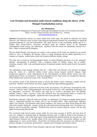
Figure 6. Examples of the cold-resistant Archaeogastropod and taxodont bivalve assemblage preserved in
the basal shellbed (FA 6).
varies from 16 - 27° towards the SE, with dips steeping towards the NNE. Importantly, these
deposits include a c. 8-12cm thick very fragmented shellbed within a well- sorted siltstone
matrix (Figure 6). The shell bed was extensively sampled for further analysis. It is dominated by
cold-resistant relatively robust archaeogastropod, taxodont bivalve taxa with subordinate
brachiopods and rare fragmented conulariida. The vast majority of shells are articulated and/or
intact. The shellbed horizon includes occasional indeterminate plant stems up to 9.6cm in length.
This facies also includes rare, moderately developed crystal clusters of glendonites up to 4.7cm in
diameter.
In the northeastern part of the study area, along strike of the shellbed ridge, Ophiomorpha trace
fossils (up to 9.8cm in length) occur in a minor Facies 6 outcrop characterized by well-sorted
fine-grained sandstone. The vertical-inclined burrows are intermittently lined with ovoid pellets,
typically 4-6mm in diameter. Furthermore, these very fragmented outcrops of Facies 6 include
elongate, possibly chemoautotrophic, deep burrows of solemyidae bivalves. Dickins (1999)
reported a similar type of bivalves from the Mid-Permian Khuff Formation in Oman.
Lower flow regime generated symmetrical wave ripples, oriented NNE – SSW, were
documented at a rare minor outcrop down dip of DH4 (Figure 7). Crestal spacing varies from 0.7 –
1.1cm.
Facies 6 is interpreted as shallow marine deposits.
The wave ripple structures were probably generated by swash and backwash currents proximal to
the paleoshoreline. The swash – backswash two way currents produces lower flow regime
symmetrical ripple marks with pointed crests and rounded troughs.
The bivalve and brachiopod species within the boreal seaway have been documented from
three sections to the east and west (e.g. Mankov et al., 2006; Manankov, 2012), however, not from
this region. The taxodont bivalve and archaeogastropod dominated assemblage probably occupied
a marginal shallow water habitat somewhat comparable to the recently documented Permian
15. New Concepts in Global Tectonics Journal, V. 4, No. 4, December 2016, p. 615-636 www.ncgt.org
Figure 7. View of minor outcrop of wave ripples preserved down dip of basal coal seam. The lower
flow regime generated symmetrical wave ripples are oriented NNE – SSW. The crestal spacing varies
from 0.7 – 1.1cm. These structures were probably generated by swash and backwash currents proximal to
the paleoshoreline.
bivalve-dominated assemblage by Simǒes et al. (2016) from the Paraná Basin in Brazil.
The presence of glendonites (i.e. pseudomorphs after ikaite) has not been reported previously,
however, it is consistent with the boreal setting advocated by Manankov et al., (2006). As a
variety of calcite, glendonites are considered here to have a relatively low preservation potential.
Selleck et al. (2007) noted that ancient glendonites may have value as recorders of the isotopic
character of the waters from which the primary ikaite precipitated if primary carbonate signatures
can be extracted.
Ophiomorpha is a substrate-controlled ichnotaxon, found mainly in fine- to medium-grained
sand deposits (e.g. Miller et al., 1998; Nagy et al., 2016). The trace fossils are the dwelling
burrows of decapod crustaceans, and common in marine shoreface environments (e.g. Uchman,
1995, Parihar et al., 2016). In a sequence stratigraphic context, trace fossil associations have
been used to characterize discontinuity surfaces (particularly at sequence boundaries) mainly
based on the recognition of substrate-controlled ichnofacies (Nagy et al., 2016).
Coal characteristics
The sedimentary record indicates that the coal-bearing package within the study area contains eight
master coal-bearing intervals. The master coal-bearing intervals may consist of a single seam or
a number of seams which are within vertical succession and which are laterally
interconnected. The boreholes’ record shows that the coal-bearing coefficient is 9.1%. The best
developed master coal-bearing interval within the study area occurs at the base.
The intersected coal seams within the study area are very broken, generally occurring as
relatively bright gravel size pieces. Total moisture from the coal core samples is often relatively
high (up to 32.79% arb with average of 13.43% arb), as the coal act as an aquifer in much of the
study area. However the inherent moisture is low (i.e. average of 1.74 adb%).
16. New Concepts in Global Tectonics Journal, V. 4, No. 4, December 2016, p. 615-636 www.ncgt.org
A total of 82 coal samples from the drill cores were analyzed at the SGS laboratory in Ulan
Bator for proximate, CV, relative density and coking properties. A number of these samples were
obtained from semi-oxidized coal due to the shallow drilling, and as such influenced the coal
quality results. Furthermore, a three ton bulk sample from a 35m deep trial shaft, sunk proximal
to drillhole #14 (Figure 2), was used for washability testing. The results from the coal core
analysis are summarized in Table 3, and raw head results (i.e. proximate and ultimate) from the bulk
sample are summarized in Tables 3 and 4.
Raw head results from the 3t bulk sample (Tables 4 and 5) shows that the coal is rather high in ash
(43.45% adb), with low inherent moisture (0.73% adb), low volatiles (8.52% adb), and
relatively low sulphur (0.54% adb) with very high gross CV (8,527 kcal/kg daf).
These results are consistent with the results from the 82 drill core samples as shown in Table 3. The
very low volatiles values in places are considered to be due to proximal felsic intrusives (i.e.
devolatilization). Relatively thin felsic dikes were documented by Erhembaatar et al. (1993) in
the four lower stratigraphic units, but are not well exposed.
The average ash content from the 82 drill core samples is 46.95% (db) and 43.45% (adb) from the
bulk sample. The consistent high ash values are unusual for Permian coal in Mongolia (cf.
Erdenetsogt et al., 2009 for a summary), and beg elucidation. The average coking properties from the
82 coal core sample was just 0.32 CSN. The maximum recorded CSN was 4.5 in drillhole #9R.
The coal would produce a very high ash, low volatiles bituminous to semi-anthracite type of
product, with low coking properties, relatively low sulphur and relatively high CV.
Depositional system
The sedimentary record clearly shows that the c. 2,600 m thick Permo-Triassic succession
within the study area was not emplaced during uniform conditions. The interlayering of fluvial
coal-bearing and shallow marine intervals indicates that high frequency sea-level shifts were an
integral part of the sedimentary dynamics influencing the sequential emplacement of the six
facies documented above. The high frequency cycles observed in the sedimentary record may
carry a 405ky orbital signal (cf. Hinnov and Ogg, 2007; Li et al., 2016).
The strongly developed annual growth rings in the fossilized wood fragments (Figure 8), coupled
with the glendonite crystal clusters in Facies 6 and outsized angular ice-rafted drop stones
observed in the lower stratigraphic marine sandstones (Figure 3), support the Boreal setting
proposed by Manankov et al. (2006).
The Late Permian peat mire ecosystem system documented by this study is thus considered to have
developed during boreal climatic conditions proximal to the shoreline of the Mongol-
Transbaikalian seaway. The seaway was likely frozen during the dark, cold winter months.
During the summer months the cold resistant peat-forming plants probably benefited from moist air
currents along the seaway with the short nights favoring steady plant growth.
The consistent high mineral matter content within the Facies 3 coal seams (average of 46.95%
db from 82 coal core samples and 43.45% adb from 3t bulk sample) is somewhat unusual for
Mongolian coals of Permian age (cf. Erdenetsogt et al., 2009), and as such require a special
explanation. The high ash content might be linked to the proximity of the shoreline coupled with a
high wind regime, with high winds mobilizing fine-grained particles along the beach area into the
peat mire.
The sedimentary record strongly indicates that the shoreline was oriented NNE-SSW (Figure 7) and
was probably very close during peat deposition. The prevailing wind direction was probably
perpendicular to the wave ripples (i.e. 100° - 280°) as indicated by the east-west orientation of the
fossil tree log.
17. New Concepts in Global Tectonics Journal, V. 4, No. 4, December 2016, p. 615-636 www.ncgt.org
Figure 8. Fragmented petrified wood showing strongly developed annual growth rings.
The immature nature of the framework grains in Facies 1 and 6 coupled with the significant
thickness of the Permo-Triassic succession within the study area (c. 2,600m) suggest relatively
rapid sediment aggradation. Microscopic analysis of selected sandstone samples revealed a very
close relationship between the sandstone units and the intrusive rocks outcropping in the NE
sector of the study area, indicating very short transport distances. Paleocurrent measurements from
one isolated outcrop suggest NNE-SSW transverse fluvial sediment dispersal (Figure 9),
Unfortunately, the age of the succession is currently poorly constrained; as such sedimentation
rates cannot be properly estimated.
Figure 9. Rose diagram of paleocurrent indicator from elongate organic debris (n=18) preserved within top
section of FA1, suggesting NNE-SSW transverse fluvial sediment dispersal.
18. New Concepts in Global Tectonics Journal, V. 4, No. 4, December 2016, p. 615-636 www.ncgt.org
The thick basal coal seam probably represents a relatively significant time span, considering the
slow growth in the boreal realm. McCabe (1987) estimated peat accretion rates at 0.1mm/pa in
arctic regions. Given that some un-drained peat deposits may contain over 90% water (Diessel,
1992), a peat compaction ratio of 10:1 is possible, and as such the un-compacted peats would have
been characterized by significant thickness in places. In this context Michaelsen et al. (2000a)
documented that clastic inter-seam deposits are proportional to the thickness of the underlying
peat deposits, with the thickest deposits of channel fill (Facies 1) developed above the thickest
accumulations of peat.
The sulphur content is relatively low with an average of 0.51% from the 82 drill core samples.
However, it is worthy of note that the vast majority of the samples were obtained from the basal
seam, which probably developed in response to a major geotectonic induced regression where the
shoreline might have significantly back-stepped basinwards and as such providing a window of
opportunity for peat mire accumulation. It is noted that significant stratigraphic evolution
occurred across the basal sequence boundary; from shallow marine sandstone dominated
facies to coal-bearing.
The drillhole record shows that the thickest seam is developed near the base of the coal
measures, whereas the upper seams are relatively thin. The three upper master coal intervals
intersected in DH02 are made up of relatively thin coal seam couplets, with the thickest seam at
the base. These seams are considered here to represent transgressive-regressive couplets (cf.
Diessel, 1992).
The rapid thickness variations and unstable nature of the coal seams suggest a syn-tectonic
influence (i.e. active growth faults). Nonetheless, primary tectonic control of the eight high
frequency coal-bearing cyclothems seems unlikely.
The rapid thickness change is illustrated in a relatively deep trench, shown in Figure 4, where the
coal seam rapidly thickens over a few meters and is characterized by wedge-shape architecture.
Another example is provided by the shallow drill holes DH09 and DH09R (drilled only 10m
apart – Figure 2), which intersected 12m and 19.75m of coal, respectively; a significant thickness
increase over just 10m.
Discussion and conclusions
Epicontinental seaways have played an important role in terms of providing accommodation
space and the depositional conditions for accumulation of significant economical deposits of
coal and hydrocarbons. Although these seaways are virtually absent from Earth today, they are the
dominant source of much of our information about marine biodiversity of the past (Harries, 2009).
It is highlighted here that the pan global Permian coal measures are unique in the evolution of the
Earth, not matched in any period before or since (Carey, 2000). Substantial global extensional
tectonic events during the Permian created the necessary accommodation space for significant
peat accumulations, and subsequent burial and preservation. In Mongolia, the Permian system is
widely distributed, not least in the South Gobi Basin, where very significant coal resources have
been preserved. Extensive field work in the South Gobi Basin since 2005 indicates that coal
deposition and preservation were controlled by an interaction of orbital climatic forcing of the
depositional processes, and somewhat complex syn-tectonic faulting. Faulting resulted in the
development of relatively deep, fault bounded sub-basins that were the locus for substantial
tracts of peat accumulation (e.g. Tavan Tolgoi coal field with potential 10Bt of coal).
The Permian system is an important part of Mongolia’s geological evolution with the two marine
basins (i.e. SMB and PMTB) and the controversial collision between the North China block and
Mongolia. According to recent work by Eizenhöfer et al. (2014), from the Late Permian to Early
Triassic double-sided subduction led to the closure of the so-called Paleo-Asian Ocean, resulting in
collision and forming the controversial Solonker Suture Zone. Intriguingly, the up to 1,000m thick
Late Permian coal measures in the South Gobi Basin does not contain tuffs, Late Permian coals are
developed proximal (c. 25-30km) north of the postulated suture zone, and the Early-Middle Triassic
19. New Concepts in Global Tectonics Journal, V. 4, No. 4, December 2016, p. 615-636 www.ncgt.org
deposits within the South Gobi Basin are characterized by very limited structural deformation. It
is also noted that the coal-bearing strata within the study area does not contain any tuffs. Detailed
studies of the Late Permian Platypus Tuff Bed in the Bowen Basin by Michaelsen et al. (2001)
showed that the tuff is well preserved over 100’s of kilometers of strike length. Unfortunately, such
tuff marker beds are absent in the Late Permian deposits in Mongolia.
Evidence of sea-level rise and fall is well displayed in Permian strata on a global scale (e.g.
Ross and Ross, Hansen et al., 2000 and Michaelsen and Henderson, 2000a; Rampino et al., 2000,
Isbell et al., 2003, Shao et al., 2007 and Li et al., 2016). Interestingly, Haq et al. (1987) identified
a total of 119 Early Triassic to Quaternary sea-level cycles, however of these only 19 (15.9%)
began with major sequence boundaries. In this context the base of the Late Permian coal
measures in the study area (i.e. implied by the FA6 shellbed), might well represent a major regional
extensive sequence boundary.
The sedimentary record documented in this study strongly indicates that the Late Permian coal
measures developed along the shores of a boreal seaway during frequent sea-level changes. These
sea-level changes are also evident by the lithologs from three logged sections of the boreal
seaway by Manankov (2004) and Manankov et al. (2006) (Figure 1). The Adatzag section
(shown by the number 1 north of Mandalgobi on Figure 1) appears to contain a total of eight
cyclothems with an average thickness of c. 100m, and spans over c. 7My from the Sakmarian to
Artinskian. Each cyclothem thus represent a time span of c. 1My and as such might represent
tectonic pulses.
Observing that every seaway is unique, the general architecture of the PMTB is considered here to
be somewhat comparable to the relatively narrow seaway developed along the western
Norwegian seaboard during Early-Middle Jurassic times (cf. Martinus et al., 2014). However,
these Jurassic seaways were interconnected and developed in a greenhouse world with elevated
temperatures. In contrast, water circulation within the narrow and relatively shallow PMTB
might have resulted in low oxygen levels in some parts, hence the relatively rare macrofossils
observed within the study area. Alternatively, the high sedimentation rates might have prevented
the Permian fauna to colonize the area.
The two underlying stratigraphic units (P2 cn1
and P2 cn2
) are characterized by a high
sandstone/mudstone ratio, dominated by marine sandstone. However, the drillhole record (DH02
and DH28) shows several horizons with common organic debris. This suggests that the peat-
forming plants were around and colonized the area but did not have sufficient time to accumulate
significant thickness.
Marine macro fossils are rare in the sedimentary record, with only one horizon at the base of the
coal-bearing unit. However, bioturbation is very common in the Late Permian stratigraphic units
both below and above the coal measures.
The coal deposits within the study area are considered here to be time equivalent to the coal-
bearing part of the Late Permian Tavan Tolgoi Group in the South Gobi Basin, and as such
representing a peat mire ecosystem developed close to the Permo-Triassic boundary.
Significantly, the vast majority (c. 95%) of peat-forming plants became extinct at this boundary
(c.f. Michaelsen, 2002). Work is currently in progress to firmly document and establish the location
of the Permo-Triassic boundary in the study area.
Acknowledgement: The following are greatly thanked for their assistance with identifying the Permian flora,
fauna and trace fossils: Paleontology Professor Robert Henderson, James Cook University, Palaeobotanist
Dr John Rigby, Queensland University of Technology, Dr Spencer Lucas, New Mexico Museum of Natural
History and Science, Dr William DiMichele and Dr Thomas Waller, Smithsonian Institution, Professor
Stephen McLoughlin, Swedish Museum of Natural History and Paleontology, Dr Jenȍ Nagy, Department
of Geosciences, University of Oslo, Associate Professor Mihai Popa, University of Bucharest, Dr Mike
Pole, Nanjing Institute of Geology and Paleontology, Dr Sebastian Voigt, Urweltmuseum GEOSKOP, and
Serge Naugolnykh, Institute of Geology, Russian Academy of Sciences. The detailed reviews by Dong Choi
and John Rigby significantly improved this contribution.
20. New Concepts in Global Tectonics Journal, V. 4, No. 4, December 2016, p. 615-636 www.ncgt.org
References
Badarch, G., Cunningham, W.D., Windley, B.F., 2002: A new terrane subdivision for Mongolia;
implications for the Phanerozoic crustal growth of Central Asia. Journal of Asian Earth Sciences 21, 87–110.
Bann, K.L., Fielding, C.R., 2004: An integrated ichnological and sedimentological comparison of non-deltaic
shoreface and subaqueous delta deposits in Permian reservoir units of Australia. Geological Society,
London, Special Publications, 228(1), 273-310.
Brand, U., Posenato, R., Came, R.E., Affek, H., Angiolini, L., Azmy, K., Farabegoli, E., 2012: The end-
Permian mass extinction: a rapid volcanic CO2 and CH4-climatic catastrophe. Chemical Geology v. 322–
323, 121–144.
Carey, S.W., 2000: Earth, Universe, Cosmos. University of Tasmania Press. Second Edition.
Clifton, H.E., 1973: Pebble segregation and bed lenticularity in wave-worked versus alluvial gravel.
Sedimentology, 20, 173-187.
Clifton H.E., 2003: Supply, segregation, succession, and significance of shallow marine conglomeratic
deposits. Bulletin of Canadian Petroleum Geology, 51 (4), 370-388.
De Vleeschouwer, D., Leather, D. and Claeys, P., 2015: Ripple marks indicate Mid-Devonian paleo-wind
directions in the Orcadian Basin (Orkney Isles, Scotland). Palaeogeography, Palaeoclimatology,
Palaeoecology 426, 68–74.
Dickins, J.M., 1999: Mid-Permian (Kubergandian - Murgabian) bivalves from the Khuff Formation,
Oman: implications for world events and correlation. Rivista Italiana di Paleontologiae Stratigrafia,
volume 105 (1), 1-2, 23-36.
Diessel, C.F.K., 1992: Coal-bearing Depositional Systems. Springer-Verlag, Berlin, 721p.
Draper, J.J., 1983: Origin of pebbles in mudstones in the Denison Trough, Proceedings of the Symposium
on Permian Geology of Queensland, Geological Society of Australia, Brisbane, 305–316.
Durante, M.V., 1976: The Paleobotanical Basis for Stratigraphy of the Carboniferous and Permian of
Mongolia: Proceedings of the Joint Soviet-Mongolian Geological Expedition, Vol. 19), Moscow: Nauka.
Eizenhöfer, P.R., Zhao, G., Zhang, J. and Sun, M., 2014: Final closure of the Paleo-Asian Ocean along
the Solonker Suture Zone: Constraints from geochronological and geochemical data of Permian volcanic
and sedimentary rocks, Tectonics, 33, 1-23.
Erdenetsogt, B.O., Lee, I., Bat-Erdene, D and Jargal, L., 2009: Mongolian coal-bearing basins: Geological
settings, coal characteristics, distribution, and resources. International Journal of Coal Geology, 80, 87-
104.
Erhembaatar, H., Dorjsuren, B. and Myagmarsuren, A., 1993: Geology research mapping report 4825.
Erwin, D.H., 1993: The Great Paleozoic Crisis. Columbia University Press, New York. Erwin, D.H.,
1994. The Permo-Triassic extinction. Nature 367, 231-236.
Hansen, H.J., Lojen, S., Toft, P., Dolenec,T., Jinan, T., Michaelsen, P. and Sarkar, A., 2000: Magnetic
susceptibility and organic carbon isotopes of sediments across some marine and terrestrial Permo-
Triassic boundaries. In: Permian-Triassic Evolution of Tethys and Western Circum-Pacific. Yin, H.,
Dickins, J.M., Shi, G.R. & Tong. J. (Eds.). Elsevier, Amsterdam, 271- 289.
Harries, P.J., 2009: Eperic seas, a continental extension of shelf biotas. Earth System: History and Natural
Variability 4, 138 – 156.
Hart, B.S. and Plint, A.G., 1989: Gravelly shoreface deposits: a comparison of modern and ancient
facies sequences. Sedimentology, 36, 551-557.
Hart, B.S. and Plint, A.G., 2003: Stratigraphy and sedimentology of shoreface and fluvial conglomerates:
insights from the Cardium Formation in NW Alberta and adjacent British Columbia. Bulletin of Canadian
Petroleum Geology, 51 (i4), 437-464.
Hinnov, L.A. and Ogg, J.G., 2007: Cyclostratigraphy and the Astronomical Time Scale. Stratigraphy, vol.
4, nos. 2/3, 239-251.
Isbell, J.L., Miller, M.F., Wolfe K.L. and Lenaker, P.A., 2003: Timing of late Paleozoic glaciation in
Gondwana: Was glaciation responsible for the development of northern hemisphere cyclothems? In: M.
A. Chan and A. A. Archer, eds., Extreme Depositional Environments: Mega End Members in Geologic
Time, Geological Society of America Special Paper, 370, 5–24.
Ito, M., Matsukawa, M., Saito, T. and Nichols, D.J., 2006: Facies architecture and paleohydrology of
a synrift succession in the Early Cretaceous Choyr Basin, southeastern Mongolia. Cretaceous
Research, 27, 226-240
Johnson, D.P., 1984: Development of Permian fluvial coal measures, Goonyella, Australia. Special
Publication 7, International Association of Sedimentologists, 149–162.
Jones, A.T., Frank, T.D. and Fielding, C.R., 2006: Cold climate in the eastern Australian mid to late Permian
may reflect cold upwelling waters. Palaeogeography, Palaeoclimatology, Palaeoecology 237: 2–4, 370–377;
Li, M., Ogg, J., Zhang, Y and Huang, C., 2016: Astronomical tuning of the end-Permian extinction and the
Early Triassic Epoch of South China and Germany. Earth and Planetary Science Letters, 1-16.
Leckie, D.A., 1994: Canterbury Plains, New Zealand — implications for sequence stratigraphic models.
American Association of Petroleum Geologists Bulletin, 78, 1240–1256.
21. New Concepts in Global Tectonics Journal, V. 4, No. 4, December 2016, p. 615-636 www.ncgt.org
Leckie D. A., 2003: Modern environments of the Canterbury Plains and adjacent offshore areas, New Zealand
– an analog for ancient conglomeratic depositional systems in nonmarine and coastal zone settings.
Bulletin of Canadian Petroleum Geology 51, (4), 389-425.
McCabe, P.J., 1987: Facies studies of coal and coal-bearing strata. In: Scott, A.C. (ed) Coal and coal-bearing
strata: recent advances. Geol. Soc. Am. Spec. Publ., 32, 51-66.
Manankov, I.N., 1998: Late Permian productida (Brachiopoda) from southeastern Mongolia:
Paleontological Journal, 32, 486–492.
Manankov, I.N., 1999: Reference section and upper Permian zonation in Southeastern Mongolia.
Stratigrafia i Geologicheskaya Korrelyatsia 7 (1), 56–65.
Manankov, I.N., 2004: New species of Early Permian brachiopods and biostratigraphy of the Boreal basin
of Mongolia. Paleontological Journal 38 (4), 366–372.
Manankov, I.N., Shi, G.R. and Shen, S.Z., 2006: An overview of Permian marine stratigraphy and
biostratigraphy of Mongolia. Journal of Asian Earth Sciences 26, 294–303.
Manankov, I.N., 2012: Brachiopods, biostratigraphy, and correlation of the Permian marine deposits of
Mongolia. Paleontological Journal, 46 (12), 1325-1349.
Martinus, A.W., Ravnȧs, R., Howell, J.A., Steel., R.J. and Wonham, J.P., 2014: From Deppositional
Systems to Sedimentary Successions on the Norwegian Continental Margin. I.A.S. Special Publication, 14.
Matsukawa, M., Nagata, H., Taketani, Y., Khanda, Y., Khosbajar, P., Badamgarav, D., Obata, I., 1997:
Dinosaur bearing Lower Cretaceous deposits in the Choir Basin, S.E. Mongolia e stratigraphy and
sedimentary environments. Journal of the Geological Society of the Philippines 52, 99-114.
Miall, A.D., 1996: The Geology of Fluvial Deposits. Springer, Berlin.
Michaelsen, P., 2016: Coal Bed Methane Potential of the Nomgon 9 PSC Area, South Gobi Basin,
Mongolia. 170 p. unpublished company report.
Michaelsen, P., 2014: Desktop review of the CBM potential of the Tavan Tolgoi coal deposit, South Gobi
Basin, Mongolia. 52 p. unpublished company report.
Michaelsen, P., 2005: Duchess Project, South Gobi Basin, Mongolia. Reconnaissance field operations:
Navtgar Uul and Khanbogd 2 districts. 23 p. unpublished company report.
Michaelsen, P., 2002: Mass extinction of peat-forming plants and the effect on fluvial styles across the
Permo-Triassic boundary, Bowen Basin, Australia. Palaeogeography, Palaeoclimatology, Palaeoecology,
179, 173-188.
Michaelsen, P., Henderson, R.A., Crosdale, P.J. and Fanning, C. M., 2001: Age and significance of the
Platypus-Tuff Bed, a regional reference horizon in the Upper Permian Moranbah Coal Measures, north
Bowen Basin. Australian Journal of Earth Sciences, 48, 183- 192.
Michaelsen, P. and Henderson, R.A., 2000a: Facies relationships and cyclicity of high-latitude, Late Permian
coal measures, Bowen Basin, Australia. International Journal of Coal Geology, 44 (1) 19-48.
Michaelsen, P. and Henderson, R.A., 2000b: Sandstone petrofacies expressions of multiphase basinal
tectonics and arc magmatism: Permian-Triassic north Bowen Basin, Australia. Sedimentary Geology,
136, 113-136.
Michaelsen, P., Henderson, R.A., Crosdale, P.J. and Mikkelsen, S.O., 2000: Facies architecture and
depositional dynamics of the Upper Permian Rangal Coal Measures, Bowen Basin, Australia. Journal of
Sedimentary Research, 70 (4), 879-895.
Michaelsen, P., Foster, C.B. and Henderson, R.A., 1999: Destabilization and collapse of a long- lived (c.
9My) peat mire ecosystem and dramatic changes of alluvial architecture: Permian- Triassic boundary,
northern Bowen Basin, Australia. Yin, H. & Tong, J. (eds.), International conference on Pangea and
the Paleozoic-Mesozoic transition, Wuhan, China, 9-11 March, 1999, 137-140.
Miller, M.F., Curran, H.A. and Martino R.L., 1998: Ophiomorpha Nodosa in estuarine sands of the lower
Miocene Calvert Formation at the Pollack farm site, Delaware. Delaware Geological Survey Special
Publication 21, 41-46.
Mironov, K.V., 1964: Geologiia mestorozhdenii uglia i goriuchikh slantsev SSSR, vol 8. Moscow,
Nagy, J. Rodríguez Tovar, F.J. and Reolid, M., 2016: Environmental significance of Ophiomorpha in
a transgressive–regressive sequence of the Spitsbergen Paleocene. Polar Research, 35, 24192.
Parihar VS, Nama SL, Khichi CP, Shekhawat NS, Snehlata M and Mathur SC, 2016: Near Shore
Shallow Marine (Ophiomorpha and Margaritichnus) Trace Fossils from Fatehgarh Formation of Barmer
Basin, Western Rajasthan, India. Journal of Ecosystem & Ecography, 6, 180, 1-6.
Pemberton, S.G. and Frey, R.W., 1982: Trace fossil nomenclature and the Planolites- Palaeophycus
dilemma. Journal of Paleontology, 56 (4), 843-881.
Postma, G. and Nemec, W., 1990: Regressive and transgressive sequences in a raised Holocene gravelly
beach, southwestern Crete. Sedimentology, 37, 907-920.
Rampino, M.R., Prokoph, A. and Adler, A., 2000. Tempo of the end-Permian event: High- resolution
cyclostratigraphy at the Permian-Triassic boundary. Geology, 28, 643-646.
Reading, H.G., Collinson, J.D., 1996: Clastic coasts. In: Sedimentary Environments: Processes, Facies and
Stratigraphy (Ed Reading, H.G.), Third Edition. Blackwell Science, 154-231.
22. New Concepts in Global Tectonics Journal, V. 4, No. 4, December 2016, p. 615-636 www.ncgt.org
Reineck, H.E., Singh, I.B., 1980: Depositional Sedimentary Environments, Second Edition. Springer
Verlag, Berlin, 551 pp.
Retallack, G.J., 2013: Permian and Triassic greenhouse crises. Gondwana Research 24, 90-103.
Ross, C.A., Ross, J.R.P., 1994: Permian sequence stratigraphy and fossil zonation. In: Embry, A.F.,
Beauchamp and Glass, D.J. Eds.., Pangea: Global Environments and Resources. Canadian Society of
Petroleum Geologists Memoir, 17, 219-231.
Selleck, B.W., Carr, P.F. and Jones, B.G., 2007: A review and synthesis of glendonites (pseudomorphs after
ikaite) with new data: assessing applicability as recorders of ancient cold water conditions. Journal of
Sedimentary Research, 77, 980–991.
Simǒes, M.G., Matos S.A., Anelli, L.E., Rohn, R. Warren, L.V., and David, L.M., 2015: A new Permian
bivalve-dominated assemblage in the Rio do Rasto Formation, Paraná Basin, Brazil: Faunal turnover
driven by regional scale environmental changes in a vast epeiric sea. Journal of South American Earth
Sciences, 64, 14 -26.
Shao L., Xiao Z., Lu J., He Z., Wang, H., and Zhang P., 2007: Permo-Carboniferous coal measures in
the Qinshui basin: Lithofacies paleogeography and its control on coal accumulation. Front. Earth Sci.
China, 1 (1): 106–115.
Storetvedt, K.M., 1999: Global Wrench Tectonics; Replacement Model for Plate Tectonics. Memoir
Geological Society of India 43: 521-547.
Surlyk, F. and Ineson, J.I., 2003: The Jurassic of Denmark and Greenland: key elements in the reconstruction
of the North Atlantic Jurassic rift system. Geological Survey of Denmark and Greenland Bulletin 1, 9–
20.
Tapponnier. P. and Molnar, P., 1979: Active faulting and Cenozoic tectonics of the TienShan, Mongolia
and Baykal regions. Journal of Geophysical Research, 84 (B7), 3425-3459.
Thomas, G.S.P. and R. J. Connell, 1985: Iceberg drop, dump, and grounding structures from Pleistocene
glacio-lacustrine sediments, Scotland, Journal of Sedimentary Petrology 55, p. 243–249.
Tong, J. and Yin, J., 1999: A study on the Griesbachian cyclostratigraphy of Meishan Section, Changxing,
Zhejiang Province. Journal of Stratigraphy, 23: 130-135.
Uchman, A., 1995: Taxonomy and palaeoecology of flysch trace fossils: The Marnoso-arenacea Formation
and associated facies (Miocene, Northern Apennines, Italy): Beringeria, v. 15, p. 3.
Yin, H., Zhang, K., Tong, J., Yang, Z. and Wu, S., 2001: The Global Stratotype Section and Point
(GSSP) of the Permo-Triassic boundary. Episodes, 24: 102-114.
Veevers, J.J., Powell, C.McA., Collinson, J.W., Lopez Gamundi, O.R., 1994: Synthesis, In: Veevers,
J.J., Powell, C.McA. Eds.., Permian-Triassic basins and foldbelts along the Panthalassan margin of
Gondwanaland. Geological Society of America Memoir, 184, 331–353.