8. Potomac River Goose Creek Town of Leesburg Rt.. 7 Power line ROW Parcel 15 Quarry B Quarry D Quarry C Quarry A Water treatment facility on Parcel 15 Loudoun Water property (Intake & Pump Station) Raw water main
9.
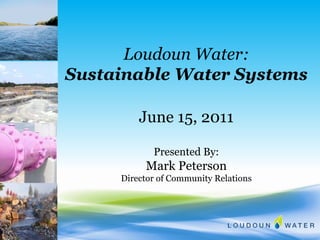
10. Benefits of Water Banking A Potomac River Intake Water Treatment Plant Central Service Area Broad Run Water Reclamation Facility Benefits of Water Banking Schematic During Low Flow Periods Goose Creek Broad Run Augmentation to the River During Low Flow
First some information about Loudoun Water: We are a state-chartered authority, meaning we get our powers from the State of Virginia. We are a political subdivision of the state, just like a Town, County or City. We are a separate entity from the County, with our own operating budget, our own source of revenue (none of it taxes) and our own staff/leadership. We are “of service” to the county, meaning, they decide when and where growth happens through THEIR Comprehensive General Plan. We only decide how. We are revenue neutral meaning the cost you pay for water and sewer is equal to our operating costs to provide those services. We have a growth pays for growth policy, which means that no current customers pays to extend (build upon) our current system for future customers. That cost is paid for by the developers who wish to build those new homes through an availability fee. Other key points: Loudoun Water is not a County agency. We offer water, wastewater and reclaimed water services to our customers in the Central Service Area. The County’s projected population growth indicates our served population will grow from 190,000 people to almost 300,00 people by 2040 plus a significant increase in the served employment population.
Large County - 520 sq. miles (top 20 in size in Virginia). Located 30 miles west of Washington DC. 40 mile shoreline w/ the Potomac River – the longest shoreline of any County in VA along the fresh water-free flowing Potomac River.
Customer growth is moving west and “Up-Hill” . 130 ft elevation difference between East and West.
Public – they get it Doing the right thing Water Banking creates a sustainable water supply for the Central Service Area Water Banking is protective of the Potomac River Water Banking increases water flow to Potomac River during drought – this is a major benefit that people and the region understand
The first phase for the Water Supply Augmentation Study is ready to begin Water Banking is like a Savings account – in good times make a deposit in the bank (from the Potomac River) and in times of need, make a withdrawal from the bank (and do not withdrawal from the Potomac River). First photo taken Oct 1998 - Potomac River 3 miles downstream of the LCSA proper Potomac River = 6BG average annual flow at Point of Rocks. During a drought, Water Banking Increases flow to the Potomac River – major benefit
6.7 miles (raw water and finished transmission main) – large diameter (42”-48”) To minimize environmental impacts – we utilized existing utility (major east coast powerline right-of-way) and transportation corridors for pipe alignment … 50% of pipe alignment on Luck Stone property, easement provided for in business agreement between Loudoun Water & Luck Stone Starts at Loudoun Water property on Potomac River … finished water main will connect to existing water mains located along Rt. 659. With this plan and Water banking we are replacing the small water supply from Goose Creek with a sustainable water supply from the Potomac River. Luck Stone quarries are ideally located near utility right-of-way for raw water pipeline alignment and near location of customer growth areas.
See how deep the quarry is. See water retention pond for rain water collection and use for dust control. Diabase rock is water tight … note rock blast next to water pond … vertical wall of blast is 50 feet depth. Note truck on top of area that was blasted.
Illustrates benefit of water banking during drought periods Savings Account – in good time make a deposit and in times of need make a withdrawal No water withdrawal from the Potomac River Will increase flow to Potomac River
Central Service Area = 150 sq. miles, mostly residential. We buy 100% of our drinking water to serve the Central Service Area. In the local water game – we’re little guys. We’re on the periphery of the Wash. Metro area We buy water from two sources and resell it to our customers. We buy 2/3 from Fairfax Water, the largest water provider in the state, and the other third from the City of Fairfax. Customers in the most eastern part of the Loudoun Water service area receive the Fairfax Water, which comes from the Potomac; and our customers in the western portion of our service area receive the Fairfax City water, which comes from a local Loudoun creek and reservoir system, within the Loudoun Water service area. The two systems are interconnected, but separated by a pressure differential. This is done to conserve energy, as the more western customers are on a ridge, and it’s difficult to push water great distances and up hill. The setup worked quite well. For awhile… The contractual agreements with our suppliers is for 50 mgd (Qmax) from Fairfax Water and 3 mgd (Qmax)from the City Our annual average water demand day is about 22 mgd with Qmax of 40 mgd in 2007. New growth in our service area is moving west and uphill from the Fairfax area. We need to provide a more sustainable water supply for these new customers moving west within the Central Service Area.
![Presentation ,[object Object],[object Object],[object Object],[object Object],[object Object]](data:image/gif;base64,R0lGODlhAQABAIAAAAAAAP///yH5BAEAAAAALAAAAAABAAEAAAIBRAA7)