SlideShare a Scribd company logo
1 of 3
Download to read offline
Pedestrian Engineering
Michael Fishman
2009

(Image credits: Seth Taras Bowery
Station Photo, GCT photo, drawings
completed at Sam Schwartz
Engineering)


The phrase ‘Pedestrian Engineering’ initially sounds like the minimization of a field of study. In fact,
pedestrians are far from banal but the most dynamic element of the urban environment. Designing for
the pedestrian is not simply a matter of widening sidewalks or connecting dots with bridges or tunnels.
Considering the future of New York (or any City), Pedestrian Engineering can result in a more fluid, safe
and comprehensible environment.
Other Cities have taken a lead in this realm (Hong Kong, Shanghi, Paris and others) separating grades to
make access safer for pedestrians; enhancing the public realm by separating the multitude of functions
that the ‘traditional main street’ has come to bear in dense urban environments. In this way, New York
can now integrate transit and street life, specify appropriate site specific land use, program, urban
design and deliver on urban revitalization and sustainability.

Quantifying the Pedestrian Experience


For generations traffic engineers have been quantifying and predicting traffic behavior with modeling
techniques and analyses to maximize vehicular throughput and improve safety on our roads and
highways. Pedestrian modeling is a relatively new technique as it is far more complex to predict human
behavior than vehicles.

The implications of Pedestrian Engineering are economic social
and physical in nature allowing for improvements to the urban
environment that facilitate pedestrian flows for day to day,
emergency evacuation or peak event scenarios.
Knowing how pedestrians will behave in a given environment
(indoors or out) saves money on infrastructure investments,
improves Levels of Service and safety as well as give investors
and decision makers a clear sense of how a site/project will
function without making costly investments in the field after the
design and construction process.
Elements of Pedestrian Engineering:
   Predicting human behavior from concept through construction.
   Staging operations, maintenance and protection of pedestrians, signage and way-finding.

Pedestrian Engineering Results:
  Safer, more comfortable, internationally comprehensible and universally accessible public spaces.
  Appropriate sidewalk, bridge and tunnel widths, vertical circulation, traffic calming and physical
  improvements to stations, hubs, event venues and streetscapes.

From Grade Separation To Grade Integration

New York invented the concept of grade separation to maximize space for urban movement with
tunnels and bridges. First in Prospect and Central Parks, Fredrick Law Olmsted was able to fold the
landscape upon itself allowing two people to occupy virtually the same space, yet exist on separate
planes.

Then, again, Louis Risse planned the Grand Concourse upon a natural ridge to avoid intersections at
grade, this was the precursor to our national highway system. Tunnels and bridges were technical
innovations at the turn of last century; today redefining at grade must go beyond such a simple
understanding of grade separation.
Pedestrian bridges and tunnels are often criticized as confining or only successful when they connect
directly to land use. People in pedestrian tunnels disappear and reappear without a sense of direction or
place. Anyone who rides the subway understands this feeling of disorientation when you resurface from
the underground. It is time for these century old techniques to reach their potential with state of the art
technologies and design.

Future densities require evolutionary solutions. From the waterfront, to the existing street network, and
underground rail or vehicular links, we can make seamless connections between existing and future
grades that will move people vertically as well as horizontally. Daylight and convenience can give the
public the feeling that they have never left the street, (plaza, ground, concourse, entry, platform) level.
Designing a framework, system, network or landscape upon which people will travel from where they
are to where they want to be, with minimal effort or confusion might best be described as ‘grade
integration’. Diligence toward this end will define a new urban landscape, as Olmstead did a century
ago, addressing the complexities that have been brought to bear on our City since his time.

The Most Frequently Asked Question: Won’t grade separation detract
from street life activity?
In some cases, yes, but this cannot be an across the board assumption.
Street can often be relegated predominantly to vehicular use (service,
valet, parking, pick up and drop off.) As we see at Grand Central Station,
retail is interior and often below grade adjacent to Metro North and
Subway entrances, N/S vehicular through movements on Park Avenue are
elevated and local street functions remain at grade with entrances,
service and bus access at grade. Several levels of movement are occurring
in the same space and this allows the main atrium at grade and the track
levels below to act as a pedestrian only zone for a complete City block.

In NYC (originally planned as a multi-level City) grade separation is
already without any ‘master plan’. One development at a time,
pedestrians ascend and descend onto elevated on decks, terraces
viaducts tunnels and passageways.
Manhattan Examples:
Downtown - WTC, SI Ferry Terminal, the Brooklyn Bridge, 55 Water Street, the FDR Deck.
West Midtown - Rail Yards, Highline, Port Authority.
West Harlem (upper Manhattan) - Riverside Park, Riverside Viaduct, 1/9, the Intrepid Museum.
East Side – FDR Drive Deck, East River Park, the UN, Brooklyn Bridge Esplanade.

Building upon this type of integrated landscape need not be as expensive as it sounds. As needs are
defined by the current and future demands of residents, commuters and tourists, there is an
opportunity to make use of much of our existing infrastructure. Highways and adjacent land uses must
be considered properly, this could generate revenues for maintenance of an enhanced public realm by
opening up valuable real estate.

No More: ‘Pardon Our Appearance’ During Construction

Public and private infrastructure projects require a wide
variety of constituents, significant intellectual and economic
investment up front and enduring commitment over time.
Improving levels of service for commuters, patients, visitors
should start at the beginning of renovations to existing
facilities. If impacts to pedestrians are a focus from ground
breaking through ribbon cutting, not only will levels of service
be maintained or improved during construction but also
staging can be designed to feel invisible (instructive) for daily
and first time users.

On-going strategies to protect an investment and the safety of
it’s users from conception through construction, operations
and maintenance is crucial. Some Public Works include a
Percent of Art Program ensuring that at a fraction of the
budget will tap a creative person for input. This is an excellent
concept although, all too often this input is not seminal to the
function of the system or facility but conceived of by those
executing the projects as decorative or ‘softening’ the rough
perception that comes with infrastructure. Especially projects
devoted to pedestrian movement or public infrastructure
located in people’s back yards.

More Related Content

What's hot

New Thesis Portfolio 8.5 x 11
New Thesis Portfolio 8.5 x 11New Thesis Portfolio 8.5 x 11
New Thesis Portfolio 8.5 x 11Craig Kelly
 
AITPM Conference Presentation - Mike Smith
AITPM Conference Presentation - Mike SmithAITPM Conference Presentation - Mike Smith
AITPM Conference Presentation - Mike SmithJumpingJaq
 
Case studies - Glenelg Tram Overpass
Case studies - Glenelg Tram OverpassCase studies - Glenelg Tram Overpass
Case studies - Glenelg Tram Overpasscircus3d
 
9/8 THUR 14:30 | TOD Toolbox :Regional & Statewide Coord. Efforts
9/8 THUR 14:30 | TOD Toolbox :Regional & Statewide Coord. Efforts9/8 THUR 14:30 | TOD Toolbox :Regional & Statewide Coord. Efforts
9/8 THUR 14:30 | TOD Toolbox :Regional & Statewide Coord. EffortsAPA Florida
 
141221_CebePortfolio_LR
141221_CebePortfolio_LR141221_CebePortfolio_LR
141221_CebePortfolio_LRJack Cebe, PLA
 
Street design guidelines feb2011-PPT
Street design guidelines feb2011-PPTStreet design guidelines feb2011-PPT
Street design guidelines feb2011-PPTParomita Roy
 
Sauchiehall workshop presentation
Sauchiehall workshop presentationSauchiehall workshop presentation
Sauchiehall workshop presentationnwplanning
 
Sauchiehall and Garnethill: summary of draft Regeneration Framework
Sauchiehall and Garnethill: summary of draft Regeneration FrameworkSauchiehall and Garnethill: summary of draft Regeneration Framework
Sauchiehall and Garnethill: summary of draft Regeneration Frameworknwplanning
 
Why india needs form based codes (rr)
Why india needs form based codes (rr)Why india needs form based codes (rr)
Why india needs form based codes (rr)Paromita Roy
 
Vision for Delhi UTTIPEC
Vision for Delhi UTTIPECVision for Delhi UTTIPEC
Vision for Delhi UTTIPECParomita Roy
 
The Streets in a Livable City
The Streets in a Livable CityThe Streets in a Livable City
The Streets in a Livable Citydrboon
 
Organic Urbanism: human-oriented design for metropolises
Organic Urbanism: human-oriented design for metropolisesOrganic Urbanism: human-oriented design for metropolises
Organic Urbanism: human-oriented design for metropolisesOleksandr Galychyn
 
Conceptual framework building sidewalk space usage control model
Conceptual framework building sidewalk  space usage control modelConceptual framework building sidewalk  space usage control model
Conceptual framework building sidewalk space usage control modelJoyce Martha Widjaya
 
Building bikeshare together
Building bikeshare togetherBuilding bikeshare together
Building bikeshare togetherMobility Lab
 

What's hot (20)

New Thesis Portfolio 8.5 x 11
New Thesis Portfolio 8.5 x 11New Thesis Portfolio 8.5 x 11
New Thesis Portfolio 8.5 x 11
 
Bhubaneswar Street Design Guidelines
Bhubaneswar Street Design GuidelinesBhubaneswar Street Design Guidelines
Bhubaneswar Street Design Guidelines
 
B'Smart
B'SmartB'Smart
B'Smart
 
AITPM Conference Presentation - Mike Smith
AITPM Conference Presentation - Mike SmithAITPM Conference Presentation - Mike Smith
AITPM Conference Presentation - Mike Smith
 
Case studies - Glenelg Tram Overpass
Case studies - Glenelg Tram OverpassCase studies - Glenelg Tram Overpass
Case studies - Glenelg Tram Overpass
 
9/8 THUR 14:30 | TOD Toolbox :Regional & Statewide Coord. Efforts
9/8 THUR 14:30 | TOD Toolbox :Regional & Statewide Coord. Efforts9/8 THUR 14:30 | TOD Toolbox :Regional & Statewide Coord. Efforts
9/8 THUR 14:30 | TOD Toolbox :Regional & Statewide Coord. Efforts
 
Somerville Broadway Streetscape Project, CAPS comments to MassDOT, March 2011
Somerville Broadway Streetscape Project, CAPS comments to MassDOT, March 2011 Somerville Broadway Streetscape Project, CAPS comments to MassDOT, March 2011
Somerville Broadway Streetscape Project, CAPS comments to MassDOT, March 2011
 
141221_CebePortfolio_LR
141221_CebePortfolio_LR141221_CebePortfolio_LR
141221_CebePortfolio_LR
 
Street design guidelines feb2011-PPT
Street design guidelines feb2011-PPTStreet design guidelines feb2011-PPT
Street design guidelines feb2011-PPT
 
SMART STEP Project: SE 8th Street & Brickell Avenue
SMART STEP Project: SE 8th Street & Brickell AvenueSMART STEP Project: SE 8th Street & Brickell Avenue
SMART STEP Project: SE 8th Street & Brickell Avenue
 
To Walk or Not to Walk
To Walk or Not to WalkTo Walk or Not to Walk
To Walk or Not to Walk
 
Sauchiehall workshop presentation
Sauchiehall workshop presentationSauchiehall workshop presentation
Sauchiehall workshop presentation
 
Sauchiehall and Garnethill: summary of draft Regeneration Framework
Sauchiehall and Garnethill: summary of draft Regeneration FrameworkSauchiehall and Garnethill: summary of draft Regeneration Framework
Sauchiehall and Garnethill: summary of draft Regeneration Framework
 
December 8, 2020 BPAC Virtual Workshop
December 8, 2020 BPAC Virtual Workshop December 8, 2020 BPAC Virtual Workshop
December 8, 2020 BPAC Virtual Workshop
 
Why india needs form based codes (rr)
Why india needs form based codes (rr)Why india needs form based codes (rr)
Why india needs form based codes (rr)
 
Vision for Delhi UTTIPEC
Vision for Delhi UTTIPECVision for Delhi UTTIPEC
Vision for Delhi UTTIPEC
 
The Streets in a Livable City
The Streets in a Livable CityThe Streets in a Livable City
The Streets in a Livable City
 
Organic Urbanism: human-oriented design for metropolises
Organic Urbanism: human-oriented design for metropolisesOrganic Urbanism: human-oriented design for metropolises
Organic Urbanism: human-oriented design for metropolises
 
Conceptual framework building sidewalk space usage control model
Conceptual framework building sidewalk  space usage control modelConceptual framework building sidewalk  space usage control model
Conceptual framework building sidewalk space usage control model
 
Building bikeshare together
Building bikeshare togetherBuilding bikeshare together
Building bikeshare together
 

Similar to Pedestrian Engineering Article

Systems Level Approach To Sustainable Urban Arterial Revitalization
Systems Level Approach To Sustainable Urban Arterial RevitalizationSystems Level Approach To Sustainable Urban Arterial Revitalization
Systems Level Approach To Sustainable Urban Arterial Revitalizationbrianhuey
 
Presentation of urban design 1
Presentation of urban design 1Presentation of urban design 1
Presentation of urban design 1Amit Pokharel
 
Thinking Highways-ICM_3-11
Thinking Highways-ICM_3-11Thinking Highways-ICM_3-11
Thinking Highways-ICM_3-11David Pickeral
 
Thinking Highways - Congestion 4-12
Thinking Highways - Congestion 4-12Thinking Highways - Congestion 4-12
Thinking Highways - Congestion 4-12David Pickeral
 
Creating a Complete Street Active Transportation Network - Mark Goode III
Creating a Complete Street Active Transportation Network - Mark Goode IIICreating a Complete Street Active Transportation Network - Mark Goode III
Creating a Complete Street Active Transportation Network - Mark Goode IIIBikeTexas
 
Complete Streets and Implementation.pdf
Complete Streets and Implementation.pdfComplete Streets and Implementation.pdf
Complete Streets and Implementation.pdfGintoAquino
 
Portfolio othman kalbouneh
Portfolio othman kalbounehPortfolio othman kalbouneh
Portfolio othman kalbounehOthman Kalboneh
 
Pedestrian priority in urban area and usefulness towards community
Pedestrian priority in urban area and usefulness towards communityPedestrian priority in urban area and usefulness towards community
Pedestrian priority in urban area and usefulness towards communityeSAT Journals
 
Pedestrian priority in urban area and usefulness
Pedestrian priority in urban area and usefulnessPedestrian priority in urban area and usefulness
Pedestrian priority in urban area and usefulnesseSAT Publishing House
 
helixator- economic and social effects
helixator- economic and social effectshelixator- economic and social effects
helixator- economic and social effectsGuy Ronen
 
UNLOCKING POTENTIAL OF URBAN LAND SPACE: BUILDING OVER RIGHT OF WAYS
UNLOCKING POTENTIAL OF URBAN LAND SPACE: BUILDING OVER RIGHT OF WAYSUNLOCKING POTENTIAL OF URBAN LAND SPACE: BUILDING OVER RIGHT OF WAYS
UNLOCKING POTENTIAL OF URBAN LAND SPACE: BUILDING OVER RIGHT OF WAYSanuarhab
 
Transit-oriented development (TOD): Integrating rail and commercial developme...
Transit-oriented development (TOD): Integrating rail and commercial developme...Transit-oriented development (TOD): Integrating rail and commercial developme...
Transit-oriented development (TOD): Integrating rail and commercial developme...Atkins
 
Urban Design Scales and Spaces for Architecture
Urban Design Scales and Spaces for ArchitectureUrban Design Scales and Spaces for Architecture
Urban Design Scales and Spaces for ArchitectureMimi Alguidano
 
Presentation Final Year Project
Presentation Final Year ProjectPresentation Final Year Project
Presentation Final Year Projectlaladude
 

Similar to Pedestrian Engineering Article (20)

Systems Level Approach To Sustainable Urban Arterial Revitalization
Systems Level Approach To Sustainable Urban Arterial RevitalizationSystems Level Approach To Sustainable Urban Arterial Revitalization
Systems Level Approach To Sustainable Urban Arterial Revitalization
 
Presentation of urban design 1
Presentation of urban design 1Presentation of urban design 1
Presentation of urban design 1
 
Urban design
Urban designUrban design
Urban design
 
2016 TOD brochure
2016 TOD brochure2016 TOD brochure
2016 TOD brochure
 
Under the Elevated
Under the ElevatedUnder the Elevated
Under the Elevated
 
Road network
Road networkRoad network
Road network
 
Thinking Highways-ICM_3-11
Thinking Highways-ICM_3-11Thinking Highways-ICM_3-11
Thinking Highways-ICM_3-11
 
Thinking Highways - Congestion 4-12
Thinking Highways - Congestion 4-12Thinking Highways - Congestion 4-12
Thinking Highways - Congestion 4-12
 
Creating a Complete Street Active Transportation Network - Mark Goode III
Creating a Complete Street Active Transportation Network - Mark Goode IIICreating a Complete Street Active Transportation Network - Mark Goode III
Creating a Complete Street Active Transportation Network - Mark Goode III
 
Complete Streets and Implementation.pdf
Complete Streets and Implementation.pdfComplete Streets and Implementation.pdf
Complete Streets and Implementation.pdf
 
Portfolio othman kalbouneh
Portfolio othman kalbounehPortfolio othman kalbouneh
Portfolio othman kalbouneh
 
Pedestrian priority in urban area and usefulness towards community
Pedestrian priority in urban area and usefulness towards communityPedestrian priority in urban area and usefulness towards community
Pedestrian priority in urban area and usefulness towards community
 
Pedestrian priority in urban area and usefulness
Pedestrian priority in urban area and usefulnessPedestrian priority in urban area and usefulness
Pedestrian priority in urban area and usefulness
 
helixator- economic and social effects
helixator- economic and social effectshelixator- economic and social effects
helixator- economic and social effects
 
UNLOCKING POTENTIAL OF URBAN LAND SPACE: BUILDING OVER RIGHT OF WAYS
UNLOCKING POTENTIAL OF URBAN LAND SPACE: BUILDING OVER RIGHT OF WAYSUNLOCKING POTENTIAL OF URBAN LAND SPACE: BUILDING OVER RIGHT OF WAYS
UNLOCKING POTENTIAL OF URBAN LAND SPACE: BUILDING OVER RIGHT OF WAYS
 
Transit-oriented development (TOD): Integrating rail and commercial developme...
Transit-oriented development (TOD): Integrating rail and commercial developme...Transit-oriented development (TOD): Integrating rail and commercial developme...
Transit-oriented development (TOD): Integrating rail and commercial developme...
 
Urban Design Scales and Spaces for Architecture
Urban Design Scales and Spaces for ArchitectureUrban Design Scales and Spaces for Architecture
Urban Design Scales and Spaces for Architecture
 
Presentation Final Year Project
Presentation Final Year ProjectPresentation Final Year Project
Presentation Final Year Project
 
Bus Stop
Bus StopBus Stop
Bus Stop
 
Highway civil
Highway civilHighway civil
Highway civil
 

Pedestrian Engineering Article

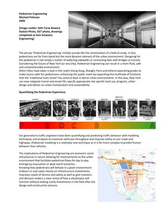
  • 1. Pedestrian Engineering Michael Fishman 2009 (Image credits: Seth Taras Bowery Station Photo, GCT photo, drawings completed at Sam Schwartz Engineering) The phrase ‘Pedestrian Engineering’ initially sounds like the minimization of a field of study. In fact, pedestrians are far from banal but the most dynamic element of the urban environment. Designing for the pedestrian is not simply a matter of widening sidewalks or connecting dots with bridges or tunnels. Considering the future of New York (or any City), Pedestrian Engineering can result in a more fluid, safe and comprehensible environment. Other Cities have taken a lead in this realm (Hong Kong, Shanghi, Paris and others) separating grades to make access safer for pedestrians; enhancing the public realm by separating the multitude of functions that the ‘traditional main street’ has come to bear in dense urban environments. In this way, New York can now integrate transit and street life, specify appropriate site specific land use, program, urban design and deliver on urban revitalization and sustainability. Quantifying the Pedestrian Experience For generations traffic engineers have been quantifying and predicting traffic behavior with modeling techniques and analyses to maximize vehicular throughput and improve safety on our roads and highways. Pedestrian modeling is a relatively new technique as it is far more complex to predict human behavior than vehicles. The implications of Pedestrian Engineering are economic social and physical in nature allowing for improvements to the urban environment that facilitate pedestrian flows for day to day, emergency evacuation or peak event scenarios. Knowing how pedestrians will behave in a given environment (indoors or out) saves money on infrastructure investments, improves Levels of Service and safety as well as give investors and decision makers a clear sense of how a site/project will function without making costly investments in the field after the design and construction process.
  • 2. Elements of Pedestrian Engineering: Predicting human behavior from concept through construction. Staging operations, maintenance and protection of pedestrians, signage and way-finding. Pedestrian Engineering Results: Safer, more comfortable, internationally comprehensible and universally accessible public spaces. Appropriate sidewalk, bridge and tunnel widths, vertical circulation, traffic calming and physical improvements to stations, hubs, event venues and streetscapes. From Grade Separation To Grade Integration New York invented the concept of grade separation to maximize space for urban movement with tunnels and bridges. First in Prospect and Central Parks, Fredrick Law Olmsted was able to fold the landscape upon itself allowing two people to occupy virtually the same space, yet exist on separate planes. Then, again, Louis Risse planned the Grand Concourse upon a natural ridge to avoid intersections at grade, this was the precursor to our national highway system. Tunnels and bridges were technical innovations at the turn of last century; today redefining at grade must go beyond such a simple understanding of grade separation. Pedestrian bridges and tunnels are often criticized as confining or only successful when they connect directly to land use. People in pedestrian tunnels disappear and reappear without a sense of direction or place. Anyone who rides the subway understands this feeling of disorientation when you resurface from the underground. It is time for these century old techniques to reach their potential with state of the art technologies and design. Future densities require evolutionary solutions. From the waterfront, to the existing street network, and underground rail or vehicular links, we can make seamless connections between existing and future grades that will move people vertically as well as horizontally. Daylight and convenience can give the public the feeling that they have never left the street, (plaza, ground, concourse, entry, platform) level. Designing a framework, system, network or landscape upon which people will travel from where they are to where they want to be, with minimal effort or confusion might best be described as ‘grade integration’. Diligence toward this end will define a new urban landscape, as Olmstead did a century ago, addressing the complexities that have been brought to bear on our City since his time. The Most Frequently Asked Question: Won’t grade separation detract from street life activity? In some cases, yes, but this cannot be an across the board assumption. Street can often be relegated predominantly to vehicular use (service, valet, parking, pick up and drop off.) As we see at Grand Central Station, retail is interior and often below grade adjacent to Metro North and Subway entrances, N/S vehicular through movements on Park Avenue are elevated and local street functions remain at grade with entrances, service and bus access at grade. Several levels of movement are occurring in the same space and this allows the main atrium at grade and the track levels below to act as a pedestrian only zone for a complete City block. In NYC (originally planned as a multi-level City) grade separation is already without any ‘master plan’. One development at a time, pedestrians ascend and descend onto elevated on decks, terraces viaducts tunnels and passageways.
  • 3. Manhattan Examples: Downtown - WTC, SI Ferry Terminal, the Brooklyn Bridge, 55 Water Street, the FDR Deck. West Midtown - Rail Yards, Highline, Port Authority. West Harlem (upper Manhattan) - Riverside Park, Riverside Viaduct, 1/9, the Intrepid Museum. East Side – FDR Drive Deck, East River Park, the UN, Brooklyn Bridge Esplanade. Building upon this type of integrated landscape need not be as expensive as it sounds. As needs are defined by the current and future demands of residents, commuters and tourists, there is an opportunity to make use of much of our existing infrastructure. Highways and adjacent land uses must be considered properly, this could generate revenues for maintenance of an enhanced public realm by opening up valuable real estate. No More: ‘Pardon Our Appearance’ During Construction Public and private infrastructure projects require a wide variety of constituents, significant intellectual and economic investment up front and enduring commitment over time. Improving levels of service for commuters, patients, visitors should start at the beginning of renovations to existing facilities. If impacts to pedestrians are a focus from ground breaking through ribbon cutting, not only will levels of service be maintained or improved during construction but also staging can be designed to feel invisible (instructive) for daily and first time users. On-going strategies to protect an investment and the safety of it’s users from conception through construction, operations and maintenance is crucial. Some Public Works include a Percent of Art Program ensuring that at a fraction of the budget will tap a creative person for input. This is an excellent concept although, all too often this input is not seminal to the function of the system or facility but conceived of by those executing the projects as decorative or ‘softening’ the rough perception that comes with infrastructure. Especially projects devoted to pedestrian movement or public infrastructure located in people’s back yards.