
Recommended
More Related Content
What's hot
What's hot (20)
Viewers also liked
Viewers also liked (12)
Similar to External geological agents sheila
Similar to External geological agents sheila (20)
More from saragalanbiogeo
More from saragalanbiogeo (20)
Recently uploaded
Recently uploaded (20)
External geological agents sheila
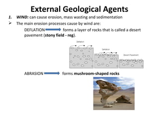
- 1. External Geological Agents 1. WIND: can cause erosion, mass wasting and sedimentation The main erosion processes cause by wind are: DEFLATION forms a layer of rocks that is called a desert pavement (stony field - reg). ABRASION forms mushroom-shaped rocks
- 2. Aeolic sedimentation when wind finds an obstacle in the landscape Sand dunes are formed (in sandy deserts (ergs)) Differents types of dunes: Barchan dunes Star dunes Transverse dunes
- 3. 2. GLACIERS: are divided into an accumulation zone and an ablation (wastage) zone along an equilibrium line. Glaciers are made up ice and snow, water, rocks and sediments. A glacier moves very slowly (few centimeters to a few meters each day).
- 4. • There are different types of glaciers: Alpine glaciers: cirques, horns, arete , U-valley, moraines (lateral, medial, end)
- 5. Continental glaciers: which are continuous masses of ice that are much larger than alpine glaciers. Small continental glaciers are called ice fields. Big continental glaciers are called ice sheets.
- 6. 3. Wild water: GREAT AMOUNT OF WATER STREAMS STREAMS ARE NON DEFINED NOR PERMANENT COURSES OF WATER RAINSTORM MODIFY THE RELIEF Smooth and homogeneous SOIL easily eroded Heterogeneous SOIL some parts are harder to erode FAIRIES’ CHIMNEYS RILL GULLY TORRENTS Intermittent , short water courses very steep slopes fixed channel ice melts or a period of heavy rains.
- 7. • 4. RIVERS: • 0.0001% of the Earth's water . • Different sources: lakes , springs (from underground), rain or melting snow and ice (high mountains) To narrow river consider its drainage basin and its floodplain: drainage basin flood plain
- 9. 1.Early maturity V-shape valley 2. Late maturity. Flat-floored valley . Narrow flood plain. River begins to meander. Flood plain widens 3. Old age. Very wide flood plain. Cut-off meanders (ox- bow lakes) Rivers (erosion) three valley shape.
- 10. • 5. Ground water • Groundwater : water in the ground is stored in the spaces between rock particles. • A groundwater aquifer is an underground layer that holds water within soil, porous rock, or similar material. • A groundwater well may be used to extract water from a groundwater aquifer.
- 11. • Karst relieves are landscapes shaped by the dissolution of a soluble bedrock layer, (usually carbonate rock such as limestone or dolomite) by a mildly acidic water. • These landscapes display different: • surface landforms (sinkholes, dolines, disappearing and reappearing streams, poljes) • underground features (extensive caves and cavern systems may be formed. In caves, the deposition of calicium carbonate may form stalactites, stalagmites, column)
- 13. SEA WATER waves, tides, sea currents erosion, transport, sedimentation processes is constantly moving has a lot of energy •6. Sea water in coastal areas THEY MODEL COASTAL AREAS WAVES Chemical Physical weathering Erosion Salty sea reacts in chemical ways with rocks and makes them weaker Stones, other sediments are carried by waves and they crash into the coastal rocks. Cliffs, sea caves, arches, abrasion platforms, sea stacks LANDFORMS
- 16. WAVES Transport and sedimentation of materials Beach: deposition of sand and gravel along the shoreline Longshore drift: This process is when individual particles are moved along the beach in a zig- zag pattern
- 17. Longshore drift Spits, bay barrier, barrier island, tombolos, lagoons… LANFORMS
- 18. The sediments (sand, mud and pebbles) accumulate in sedimentary basins , forming layers or plies. These layers of sediment are sinking deeper and deeper into the basins. Under conditions of high temperatures and high pressures The sediments become rock (lithified) through a process called DIAGENESIS (it may take millions of years) SEDIMENTARY ROCKS Clastic sedimentary rocks such as conglomerate, sandstones, shale . Chemical sedimentary rocks, such us halite, gypsum Organic sedimentary rocks such us limestone, coal. Types of sedimentary rocks