
Recomendados
Recomendados
Mais conteúdo relacionado
Destaque
Destaque (20)
GPS技术问题.pptx
- 3. GPS定位原理
- 4. GPS定位原理
- 5. GPS定位原理
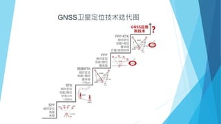
- 6. GNSS 频率
- 7. 吉利要求 高通性能 WNC 性能 Valeo 测试 备注 TTFF 冷启动 30s/33s 28s 35s 温启动 15s 24s 34s 热启动 2s 1s / 重新定位时间 5s 2s / 卫星信号丢失60s内 冷启动灵敏度 -150dbm -148dbm -143dbm 跟踪灵敏度 -160dbm -59dbm -160dbm 定位精度 7.5米 5米 / HDOP<2.5(CEP95) GPS性能要求比较 Valeo 要求C/N0>26dBHz为Acceptable,C/N0>36dBHz为OK。
- 10. NAD9628 Sensitivity Performance 卫星强度(dbm) CN0(dBHz) cold Start Warm Start Hot Start -125dbm 49dBHz -130dbm 44dBHz -135dbm 39dBHz 28s 24s 1s -145dbm 29dBHz 81s 27s 4s -148dbm 26dBHz 300s / / -159dbm 15dBHz Acquisition sensitivity Qualcomm All sensitivity and accuracy numbers assume 2.5dB GPS noise figure. Weak signal: ≥ 8 GPS SVs + ≥ 8 GLO SVs with power -145dbm GPS signal in Open Sky is -125~-130dbm Qualcomm 宣称性能:
- 12. GPS信号发送给IHU Operation Name Note PosnFromSatltPush 1,经纬度(posnlat,posnlgt) 由NAD输出, 如果为0使用上一次值。 现在改为由GPS和北斗融合定位获取结果。 2,gps status, 未定位到为0 3,时间(如果无法从GPS获取)将由MCU RTC计算而得。 4,GNSSSolution定位中使用的卫星系统。比如北斗,GPS GNSSRawInfo 1,原始数据,提供给IHU做惯性导航用,以及在界面显示可见卫星数。 2,替换GPGGA中的经纬度(22R2)。 CAN Signal Only for ADCU to compare the signal from IPCP
- 13. GPS信号TCAM发送给IHU NMEA信号 NMEA 参数 GPGSA GPS DOP and Active Satellites 当前可用卫星编号和定位状态(包括是否定位和定位类型) GPGSV GPS Satellites in View(GSV) 可见卫星编号,卫星方位角度和信噪比 GPVTG Course and speed information 地面速度信息包括地面航向和地面速率 GPGGA Global Positioning System Fix Data UTC 时间,经纬度,HDOP,海拔高度,正在使用的卫星数量和GPS状态 GPRMC Recommended Minimum Specific GNSS Data UTC 时间,经纬度,地面速率(单位节),地面航向,磁偏角方向 建议: 1) 北斗卫星可用状态显示,使用语句:$GNGSA 2) 可见北斗卫星信号,供IHU做惯性导航用,输出$GBGSV 3) 替换$GPGGA,$GPRMC中的经纬度,兼容之前的软件,同时输出$GNGGA,$GNRMC
- 14. GPS定位性能测试项目 场景 1 C/N0值测试 两个方向各测试12个小时,用来衡量接收信号 2 HDOP HDOP用来衡量定位精度 3 冷启动TTFF 测试10次取平均值, 4 天线匹配测试 Valeo 标准的GPS测试用于衡量TCAM安装在车上性能,作为性能评估标准,包括如下测试 测试方法: 1 车头朝向0 和180°各测试12小时(因为GPS卫星12个小时重复一遍) 2)测试使用U-Center和excel表统计。 https://www.u-blox.com/en/product/u-center GNSS_data_computation_example_void_position2
- 16. 遮蔽对GPS影响 GPS信号受到遮蔽物影响,建议测试如下场景 场景 模拟现象 City block Urban area with an average building height of 20 m. Urban canyon Dense urban area with an average building height of 30 m. Suburban area Suburban building density at relatively large distance from receiver (40 m on each side). Highway Periodic short-term obscuration from passing vehicles on opposite lane and (noise) barriers on the other side. Cutting Natural or urban cutting. Bridge Periodic obscuration from bridges. Parking Obscuration with varying durations due to parking in parking decks. Tunnel Obscuration due to tunnels. GPS信号衰减:隔热玻璃可以达到17dB, 钢板12dB
- 18. GPS信号TCAM发送给IHU NMEA信号 NMEA 参数 GPGSA GPS DOP and Active Satellites 当前可用卫星编号和定位状态(包括是否定位和定位类型) GPGSV GPS Satellites in View(GSV) 可见卫星编号,卫星方位角度和信噪比 GPVTG Course and speed information 地面速度信息包括地面航向和地面速率 GPGGA Global Positioning System Fix Data UTC 时间,经纬度,HDOP,海拔高度,正在使用的卫星数量和GPS状态 GPRMC Recommended Minimum Specific GNSS Data UTC 时间,经纬度,地面速率(单位节),地面航向,磁偏角方向