NJFuture Redevelopment Forum 2016 Bristol
•
1 gostou•754 visualizações

Presentation from New Suburbanism session

Recomendados
Mais conteúdo relacionado
Destaque
Destaque (20)
Semelhante a NJFuture Redevelopment Forum 2016 Bristol
Semelhante a NJFuture Redevelopment Forum 2016 Bristol (20)
Mais de New Jersey Future
Mais de New Jersey Future (20)
Último
Último (20)
NJFuture Redevelopment Forum 2016 Bristol
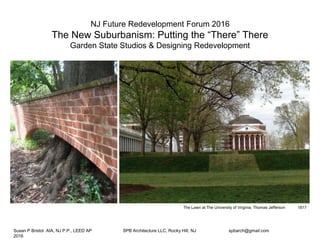
- 1. NJ Future Redevelopment Forum 2016! The New Suburbanism: Putting the “There” There! Garden State Studios & Designing Redevelopment The Lawn at The University of Virginia, Thomas Jefferson 1817 Susan P Bristol AIA, NJ P.P., LEED AP SPB Architecture LLC, Rocky Hill, NJ spbarch@gmail.com 2016
- 2. ‘Super (fund) Site’: Mix Use Redevelopment, Rustic Mall, Manville, NJ 2010 ‘Fuel to Food’: Agriculture Innovation Center! Delaware River, Petty Island, Camden, NJ 2012 ‘Un-building’ the Jersey Shore: Barrier Island Boro Hall! Squan Island, Bay Head, NJ 2013 ‘Upstream’: Capsizing the Strip Mall! Upper Passaic River Basin, Pequannock, NJ 2014 Susan P Bristol AIA, NJ P.P., LEED AP SPB Architecture LLC, Rocky Hill, NJ spbarch@gmail.com 2016 GARDEN STATE STUDIOS at NJIT – Designing ReDevelopment CASE STUDY Upstream: Capsizing the Strip Mall Plaza 23, Pequannock, NJ
- 3. Garden State Studio Challenge for ‘Upstream’: How do we ReDevelop Dead Malls & Aging Architectural Infrastructure?! Wayne Hills Mall built approximately 40 years ago Patch File photo/02/23/16, story by Daniel Hubbard Redevelopment: To change the architecture, layout, decor, or other component of a shopping center to a6ract more renters and draw more profits. Some;mes redevelopment can involve a switch from retail usage to office or educa;onal usage of a building. deadmalls.com Photo by Demitrius Balevski of NorthJersey.com ‘Labelscar’ at Plaza 23 (as defined by deadmalls.com) Redevelopment: To design a more sustainable, economically viable, multi-use and integrated project that enhances adjacent built and natural environments. SPB, Garden State Studio Susan P Bristol AIA, NJ P.P., LEED AP SPB Architecture LLC, Rocky Hill, NJ spbarch@gmail.com 2016
- 4. 15 POMPTON FAMILY DENTAL MOE’S SOUTHWESTGRILL POMPTONFAMILY HAIRCARE PARAGONJEWELERS V&JPIZZA EYEDRX SUNNAIL&SPA BUY RITE LIQUOR & WINE AVAILABLE 3,600SF AVAILABLE 1,800SF AVAILABLE 1,600SF AVAILABLE 1,807SF AVAILABLE 1,600 SF ANCHOR SPACE AVAILABLE 65,031 SF 15 16 13-14 9-11 876543A321C1B1A1.11 12-12A NEW YORK CONNECTICUT MASSACHUSETTS PENNSYLVANIA MARYLAND DELEWARE ATLANTIC OCEAN http://www.hekemian.com/property/plains-plaza/ Deborah Smith – Farms View Susan P Bristol AIA, NJ P.P., LEED AP SPB Architecture LLC, Rocky Hill, NJ spbarch@gmail.com 2016 CASE STUDY Upstream: Capsizing the Strip Mall Plaza 23, Pequannock, NJ
- 5. Susan P Bristol AIA, NJ P.P., LEED AP SPB Architecture LLC, Rocky Hill, NJ spbarch@gmail.com 2016 Upstream: Capsizing the Strip Mall site photos
- 6. Upstream: Capsizing the Strip Mall the flood(s) Jerry McCrea/Star Ledger 10-26-12 Susan P Bristol AIA, NJ P.P., LEED AP SPB Architecture LLC, Rocky Hill, NJ spbarch@gmail.com 2016
- 7. Upstream: Capsizing the Strip Mall the river Susan P Bristol AIA, NJ P.P., LEED AP SPB Architecture LLC, Rocky Hill, NJ spbarch@gmail.com 2016
- 8. Upstream: Capsizing the Strip Mall infrastructure history Illustration by Herbert M. Wilson, CE Susan P Bristol AIA, NJ P.P., LEED AP SPB Architecture LLC, Rocky Hill, NJ spbarch@gmail.com 2016 Pompton Plains Rail Station, 1872/National Register Historic Places, 2008
- 9. =========== =========== = = = = = = // ‘Upstream’: Capsizing the Strip Mall NJIT 5th year Comprehensive studio EXISTING • Automobile Oriented • Single Use • Continuous Slab • No ‘There’ there • Impervious Paving Vs. PROPOSED • Pedestrian Oriented • Mixed Use • Ground Connections • Place making • Landscape ‘UPSIDE DOWN PLANNING’
- 10. Upstream: Capsizing the Strip Mall mixed-use precedents! Copenhagen Mix Use/U. Va., Pavillion VII, T. Jefferson/8 House, BIG/The Mountain, BIG Susan P Bristol AIA, NJ P.P., LEED AP SPB Architecture LLC, Rocky Hill, NJ spbarch@gmail.com 2016
- 11. Upstream: Capsizing the Strip Mall ground connection precedents! Susan P Bristol AIA, NJ P.P., LEED AP SPB Architecture LLC, Rocky Hill, NJ spbarch@gmail.com 2016 Bieneke Rare Books Library, SOM, Yale Morris Arboretum, Overland Arch., PA Nordic Institute, Alvar Aalto, Reyjjkavik, Iceland Kresge Auditorium, Saarinen, MIT
- 12. Upstream: Capsizing the Strip Mall place-making precedents ! Bathing Pavilion, White Arch, Denmark Bench, Institute for Advanced Study, Princeton Pedestrian Bridge, Reyjkiavik, Iceland Genomics Labs, R. Vinoly, Princeton University Copenhagen Plaza with children’s fountain Susan P Bristol AIA, NJ P.P., LEED AP SPB Architecture LLC, Rocky Hill, NJ spbarch@gmail.com 2016
- 13. Upstream: Capsizing the Strip Mall landscape precedents! Morris Arboretum, PA Netherlands Landscape Pattern Fontana Spa, Iceland High Line, Diller Scofidio Renfro, NYC Morris Arboretum, PA Contemporary Art Museum, Renzo Piano, Oslo, Norway Rain Garden, Princeton Seminary, NJ Susan P Bristol AIA, NJ P.P., LEED AP SPB Architecture LLC, Rocky Hill, NJ spbarch@gmail.com 2016
- 14. SMELL: DECATING ORGANIC MATTER SOUND: RUSHING WATER TO“BABLLING BROOK”FURTHER DOWNSTREAM SMELL: GASOLINE AND ROAD SALT SOUND: HIGHWAY TRAFFICAdam Morgan & Alex Guimaraes Upstream: Capsizing the Strip Mall site reading STUDIO ASSIGNMENTS: 1 Capsized: From Hull to Hall 2 Site Reading 3 Pile,Platform, Pier & Plinth 4 Tectonic Exploration 5 Wall Sections & Green Systems Susan P Bristol AIA, NJ P.P., LEED AP SPB Architecture LLC, Rocky Hill, NJ spbarch@gmail.com 2016
- 15. Andrea Camargo 01 Susan P Bristol AIA, NJ P.P., LEED AP SPB Architecture LLC, Rocky Hill, NJ spbarch@gmail.com 2016 Upstream: Capsizing the Strip Mall research
- 16. Andrea Camargo 02 Susan P Bristol AIA, NJ P.P., LEED AP SPB Architecture LLC, Rocky Hill, NJ spbarch@gmail.com 2016 Upstream: Capsizing the Strip Mall research
- 17. B L D G C O N C E P T Susan P Bristol AIA, NJ P.P., LEED AP SPB Architecture LLC, Rocky Hill, NJ spbarch@gmail.com 2016 Upstream: Capsizing the Strip Mall analysis Andrea Camargo 03
- 18. Susan P Bristol AIA, NJ P.P., LEED AP SPB Architecture LLC, Rocky Hill, NJ spbarch@gmail.com 2016 Upstream: Capsizing the Strip Mall site strategy Andrea Camargo 04
- 19. Andrea Camargo 05 Susan P Bristol AIA, NJ P.P., LEED AP SPB Architecture LLC, Rocky Hill, NJ spbarch@gmail.com 2016 Upstream: Capsizing the Strip Mall rendering
- 20. Studio Introduction : Capsized Erosion of Riverbank creates a natural debris filter Site Inspiration While on the site visit I came across a small channel that had been carved into the ground from the water draining from the paved surfaces of the site. This eroded section generated the idea of creating a building that would not only channel movement through it, but become a system for filtering different levels of activity and usage. In this sense the roots and tendrils of the various plants all joined together to break down the space while at the same time being the very fabric that holds it together, creating a natural order which created a unique site experience. Flood zones in the surrounding area Local Flooding Zones Being in the low-lying areas below the mountains to the west, the area in close proximity to the site is all part of the flood plain which has caused large spread damages in past heavy rainfall events. Across the river, for the most part, is raised above to a higher plane which creates a semi-flood basin on the Pequannock side of the Pompton River. Most of the commercial infrastructure in place along Route 23 is subject to the lowest levels of flooding which has prompted the design challenge for th studio to find a solution to mitigate the losses from building in a flood plane. Typically a wood or metal gate that is raised to allow water to pass under Landscape Inspiration : Sluice Gates Sluice gates are typically used to control the amount of water that is able to flow through a certain system which is typically something along the lines of a channel or linear water passageway. After the initial design problem and the site visit I found that the natural feature formed by the runoff created natural sluice box, a device typically used in mining or in panning for gold. When used at small scale the sluice box works as a small filtering system wherein the heavy materials are trapped along the ribs, while the dirt and water flow through the box effectively separating the two. The gates signify a point of interaction and movement, wherein lifting them creates the point of entry into the next area which would be translated into the entryway and circulation systems of the building. Erosion of Riverbank creates a natural debris filter The first assignment for the studio project this semester was to represent a portion of a typical strip mall in terms of a physical model. The challenge was to then re-imagine the model in a new form, to capsize the standard thoughts and redesign what the structure and components could be in order to create a design that could be more resilient. By capsizing the model the structure of the building became a series of ribs that could serve as terracing methods or ways to break down the landscape and building. 50 yr. Flood Zone 100 yr. Flood Zone 500 yr. Flood Zone Building ZoneBuilding Zone ngdinildBuiBuB neoneZoZg Site Flooding : The Issue 1. Commercial Front : Separation of Route 23 from the Plaza to create a wetlands area. Setback so that the new facade is aligned with the typical back facade of a other Route 23 shops. 2. Site Entrances : Existing New Re-use of the existing site entrance from Route 23, as well as the creation of two new site entrances along the 3. Access Edges : Residential and support service entry along the outer edges of the site alongside new wooded boundaries. Boat drop off / portage areas are at the end of each residential drive. Residential parking garages on the perimeters of the site raised above flood levels. 4.Building Division : The building is separated into two business types; anchor stores and office building along the Route 23 facade, and small retail / residential moving towards the river. The two zones are linked in the center with the Arts Gallery as well as the main enterance to the building. 5. Structure as Sluice Gates : Separation of Route 23 from the Plaza to create a wetlands area. Setback so that the new facade is aligned with the typical back facade of a other Route 23 shops. 6. Site Path Division : The main link between the two buildings is a path connecting the two Arts Gallery spaces at the main entrances of each building. Smaller footpaths run over the landscape within the parking lot to create access points to the various parking areas. At the end of the parking lot is a boardwalk path that adjoins a small park, creating a space for small pop-up vendors to sell their goods. Boat drop Boat drop AnchorStores SmallerStores ParkEdge ParkingCrossing MainLinkPath ParkingCrossing The site flooding in Hurricanes Irene and Sandy Credit : Justin Zaremba Credit : D’Angelo - Dolzman Credit : C. Mc.Mahon Aaron Krassowski 01 Susan P Bristol AIA, NJ P.P., LEED AP SPB Architecture LLC, Rocky Hill, NJ spbarch@gmail.com 2016 Upstream: Capsizing the Strip Mall site analysis & strategy
- 21. Aaron Krasswowski 02 Susan P Bristol AIA, NJ P.P., LEED AP SPB Architecture LLC, Rocky Hill, NJ spbarch@gmail.com 2016 Upstream: Capsizing the Strip Mall research & work RE-Structuring Parking and Buildings: Integration Blue Land Intervention For my intervention I am interested in looking at how parking and transporta- tion can be integrated into th infrastructure of the building environment. After the precedent set in the early 20th century, the American commercial scape has become a pairing of the building infrstructure and transportation infrastructure. In most cases such as the existing condition on the site, the two are paired together as large components with little to no integration. The site creates a unique opportunity to explore the condition as it sits on the corner site of a major link between the townships of Wayne and Peaquannock right at the edge of the river. The other boundary of the site is a six lan roadway that serves as a major artery for the surrounding areas to pass through on a regualar basis.As it stands the site currently uses the corner real estate as a parking lot by tucking the building as close to the river as possible which creates a dead land between the road and the building. My intervention will follow along a path set by Austrian born architect Victor Gruen who is better known as the father of the american mall. The site reminds me of a work that I studied for a thesis paper which was on a corner street in downtown LA where there was a dire need to keep a set ratio of parking to building while at the same time a desire to keep the building low to fit into the surrounding context. Whilethe site in Peaquannock doesn’t share all of the same properties, it does present a unique corner condition that can be untegrated better with the parking infrastructure to create a nevel level above the flood plane as well as to create more availble land for park space along the edge of the river. Selected idea of study: Milliron Store by Victor Gruen. The Milliron Store worked by creating a central core that would transport customers down into the store from the parking on the roof while also providing space for amenities that would otherwise not exist in that space. The roof had a resteraunt, childcare center, and a massage area which were meant to integrate businesses together with the infrstracture of parking and building as one. At the same time this move allowed the street edge of the building to remain a pedestrian pathway which meant larger side walks and public gathering areas. While the Milliron store was certainly located in a different type of setting, the idea of integrating businesses together with the infrastructure needed on the site is critical for gaining symbiotic relationships. While the parking does not necessarily have to be on the roof of the building, the ingegration of the parking in a manner beyond that of a parking lot would yield an alternative approach to responding to the flood waters. For the intervention what I would like to pursue is an idea that follows the form of the commerical building which is one of adaptable building structure that can be used for whatever requirement is needed. As an example having the building be be raised structurally to create bays that can be used for local vendors and small businesses on a week by week basis while at the same time making an infrastructure that is usable during a flood time. While the location is not one of a downtown setting, a density of homes could create a living collective where the residents would want to integrate with local business rather than pushing it to the borders of the town. Business Infrastructure Response Infrastructure Consumer Infrastructure Natural Infratructure
- 22. Upstream: Capsizing the Strip Mall presentation board Lara Saleh 01 Susan P Bristol AIA, NJ P.P., LEED AP SPB Architecture LLC, Rocky Hill, NJ spbarch@gmail.com 2016
- 23. Upstream: Capsizing the Strip Mall site strategy Susan P Bristol AIA, NJ P.P., LEED AP SPB Architecture LLC, Rocky Hill, NJ spbarch@gmail.com 2016 Lara Saleh 02
- 24. Lara Saleh 03 Susan P Bristol AIA, NJ P.P., LEED AP SPB Architecture LLC, Rocky Hill, NJ spbarch@gmail.com 2016 Upstream: Capsizing the Strip Mall work
- 25. Lara Saleh 04 Upstream: Capsizing the Strip Mall rendering
- 26. Sandra Galvan 01 Susan P Bristol AIA, NJ P.P., LEED AP SPB Architecture LLC, Rocky Hill, NJ spbarch@gmail.com 2016 Upstream: Capsizing the Strip Mall presentation board
- 27. Susan P Bristol AIA, NJ P.P., LEED AP SPB Architecture LLC, Rocky Hill, NJ spbarch@gmail.com 2016 Upstream: Capsizing the Strip Mall rendering Sandra Galvan 02
- 28. AGRICULTURAL FABRIC EXISTING RETAIL SF FOOTPRINT INTERVENTION SITE SHEAR SITE STITCH THE SITE IS CONNECTED THROUGH A MAJOR WATERWAY, THE POMPTON RIVER WHICH FEEDS DOWNSTREAM INTO THE PASSAIC RIVER, AND TWO MAJOR ROADWAYS, STATE ROUTE 23 + JACKSON AVE. SEPARATED BY COUNTY BORDERS, TOWN BORDERS, AND A MAJOR HWY, THESE RESIDENTIAL NEIGHBORHOODS HAVE NO PEDESTRIAN CONNECTION WITH EACH OTHER, THE LOCAL FARM, OR A COMMUNAL PARK SPACE EVEN THOUGH THE CONNECTION BETWEEN THESE REGIONS IS WALKABLE, THIS IS NOT POSSIBLE WITHOUT A SAFE MEANS OF CIRCULATION AND PROPER MOVEMENT BETWEEN THESE REGIONS RIVER + HWY MAJOR ZONES WALKING RADIUS THE PLAZA 23 SITE SITS AT THE THRESHOLD BETWEEN ALL OF THESE MAJOR REGIONS WITH HOLDS THE OPPORTUNITY TO BLUR THE COUNTY AND TOWN LINES AND STITCH ALL OF THESE REGIONS TOGETHER. CONNECTIONS STATE ROUTE 23 POMPTON RIVER RAMAPO RIVER JACKSON AVE 1/4 MI. RADIUS 1 MI. RADIUS RESIDENTIAL RESIDENTIAL 1/2 MI. RADIUS FARMS VIEW ROADSTAND RESIDENTIAL Susan P Bristol AIA, NJ P.P., LEED AP SPB Architecture LLC, Rocky Hill, NJ spbarch@gmail.com 2016 Alex & Adam 01 Upstream: Capsizing the Strip Mall site analysis & strategy
- 29. Adam Morgan EXISTING SITE 806,580 SF PROPOSED SITE 295,380 SF OF CONSTRUCTED WETLANDS PROPOSED SITE THE CONSTRUCTED WETLANDS ARE DESIGNED TO RETAIN A 100 YEARS STORM ON SITE AND RELEASE THE WATER BACK INTO THE WATER-TABLE 100 YEARS STORM 8” OF RAIN = 540,400 CF CONSTRUCTED WETLANDS AREA 580,000 CF Susan P Bristol AIA, NJ P.P., LEED AP SPB Architecture LLC, Rocky Hill, NJ spbarch@gmail.com 2016 Alex & Adam 02 Upstream: Capsizing the Strip Mall site model
- 30. AREA OF DEVELOPMENT SCALE 1/64” = 1’-0” MASTER PLAN Alex Guimaraes & Adam Morgan Master Plan 02 Upstream: Capsizing the Strip Mall site plan Susan P Bristol AIA, NJ P.P., LEED AP SPB Architecture LLC, Rocky Hill, NJ spbarch@gmail.com 2016
- 31. second floor plan 0 4 8 16 32 64’ 18 13 13 20 19 13 mechanical room 18 offices 19 community gardens 20 mountain overlook first floor plan 0 4 8 16 32 64’ 8 10 10 11 1212121212 13 14 15 16 17 9 8 restaurant 9 pedestrian bridge 10 art studio 11 v & j pizza 12 retail store 13 mechanical room 14 coat room 15 community gallery 16 outdoor deck 17 new shopping level ground floor plan 0 4 8 16 32 64’ f e e f h h 1 2 43 2 5 6 1 farmers market 2 bicycle storage 3 loadining area 4 residential parking 5 main lobby 6 mail room 7 ramp to new shopping level pedestrian plaza el. +193’ pedestrian way el. +200’-6” existing grade el. +180’ crest of river el. +170’ fema flood el. el. +186’ 0 8 16 32 64 128’ site plan scale: 1/64” = 1’ a-a b-b c-cd-d d-d PAVING 536,000 SF PAVING 275,000 SF BUILDING FOOTPRINT 162,000 SF BUILDING FOOTPRINT 128,000 SF PARKING 889 SPACES PARKING 420 SPACES GREEN SPACE 120,OOO SF BUILDING BREAKDOWN PERVIOUS VS. IMPERVIOUS BUILDING BREAKDOWN PERVIOUS VS. IMPERVIOUS GREEN SPACE 415,OOO SF EXISTINGPROPOSED 61.7% 38.3% 14.7% 85.3% 50.7% 15.6% 33.7% (11%) 65.5% (20%) 19.8%14.7% sidwell friends school|kieran timberlake plantide|dordrecht, netherlands|stijlgroep NEW YORK CONNECTICUT MASSACHUSETTS PENNSYLVANIA MARYLAND DELEWARE ATLANTIC OCEAN RESIDENTIAL 20,000 SF COMMUNITY 10,000 SF RETAIL 20,000 SF ANCHOR STORES 1000 SFBIG BOX RETAIL 100,000 SF SMELL: DECATING ORGANIC MATTER SOUND: RUSHING WATER TO“BABLLING BROOK”FURTHER DOWNSTREAM SMELL: GASOLINE AND ROAD SALT SOUND: HIGHWAY TRAFFIC ‘UPSTREAM’ GARDEN STATE STUDIO HIGHL ANDS PIEDM ONT INNER COAS TAL PLAIN OUTER COASTAL PLAIN PINELANDS VALLE Y + RIDG E north elevation h-h scale: 1/8” = 1’ 0 1 2 4 8 16’ pedestrian plaza el. +193’ pedestrian way el. +200’-6” existing grade el. +180’ crest of river el. +170’ fema flood el. el. +186’ pedestrian plaza el. +193’ pedestrian way el. +200’-6” existing grade el. +180’ crest of river el. +170’ fema flood el. el. +186’ 8’ site section a-a pedestrian greenway scale: nts site section b-b parking bioswale scale: nts site section c-c pedestrian link scale: nts site section b-b parking bioswale scale: nts site section d-d scale: 1/16” = 1’ building section f-f scale: 1/8” = 1’ site section a-a pedestrian greenway scale: nts 0 2 4 8 16 32’ residential unit plans scale: 1/8”=1’ 2 bed rm 1165 sf (x4) studio 440 sf (x6) 1 bed rm 675 sf (x6) retail unit plan scale: 1/8”=1’ v & j pizza 2450 sf 0 1 2 4 8 16’ elevated to allow vehicular circulation underneath elevated to comply with fema flood elevation fema flood el. el. +186’ typ. city block residential plan building section e-e scale: 1/8”=1’ 0 1 2 4 8 16’ pedestrian plaza el. +193’ pedestrian way el. +200’-6” existing grade el. +180’ fema flood el. el. +186’ wall section scale: 1/2” = 1’ 0 3” 6” 1’ 2‘ 4’ pedestrian plaza el. +193’ pedestrian way el. +200’-6” existing grade el. +180’ fema flood el. el. +186’ EXISTING SITE 806,580 SF PROPOSED SITE 295,380 SF OF CONSTRUCTED WETLANDS PROPOSED SITE THE CONSTRUCTED WETLANDS ARE DESIGNED TO RETAIN A 100 YEARS STORM ON SITE AND RELEASE THE WATER BACK INTO THE WATER-TABLE 100 YEARS STORM 8” OF RAIN = 540,400 CF CONSTRUCTED WETLANDS AREA 580,000 CF RIVER NEIGHBORHOODS & FARM LINKING OF NEIGHBORHOODS & RIVER-WALK WITH SITE bridging access and resilience Responding to the new fema base flood elevation, the building bridges the pedestrian link and this new datum; providing a threshold into the site for both pedestrians and vehicles. the building’s gradual tilt to achieve this gentle transition requires the traditional floor of a building to me rethought as a series of stepped levels. the building’s tilt is the embod- iment of the tension between the site’s dichotomy at multiple scales: the highlands and piedmont, pequannock and wayne, mountains and river. Susan P Bristol AIA, NJ P.P., LEED AP SPB Architecture LLC, Rocky Hill, NJ spbarch@gmail.com 2016 Upstream: Capsizing the Strip Mall design presentation board Adam Morgan
- 32. first floor plan 0 4 8 16 32 64’ 8 10 10 11 1212121212 13 14 15 16 17 9 8 restaurant 9 pedestrian bridge 10 art studio 11 v & j pizza 12 retail store 13 mechanical room 14 coat room 15 community gallery 16 outdoor deck 17 new shopping level ground floor plan 0 4 8 16 32 64’ f e e f h h 1 2 43 2 5 6 1 farmers market 2 bicycle storage 3 loadining area 4 residential parking 5 main lobby 6 mail room 7 ramp to new shopping level Adam Morgan Susan P Bristol AIA, NJ P.P., LEED AP SPB Architecture LLC, Rocky Hill, NJ spbarch@gmail.com 2016 Upstream: Capsizing the Strip Mall design plans
- 33. site section d-d scale: 1/16” = 1’ 0 2 4 8 16 32’ pedestrian plaza el. +193’ pedestrian way el. +200’-6” existing grade el. +180’ crest of river el. +170’ fema flood el. el. +186’ pedestrian plaza el. +193’ pedestrian way el. +200’-6” existing grade el. +180’ crest of river el. +170’ fema flood el. el. +186’ north elevation|section h-h 0 4 8 16 32 64’ pedestrian plaza el. +193’ pedestrian way el. +200’-6” existing grade el. +180’ crest of river el. +170’ fema flood el. el. +186’ north elevation|section h-h 0 4 8 16 32 64’ [ORTHOGRAPHIC DRAWINGS|BUILDING SECTIONS & ELEVATIONS] GARDEN STATE STUDIO ‘UPSTREAM’ 21 Susan P Bristol AIA, NJ P.P., LEED AP SPB Architecture LLC, Rocky Hill, NJ spbarch@gmail.com 2016 Alex Guimaraes Upstream: Capsizing the Strip Mall design sections Adam Morgan
- 34. Susan P Bristol AIA, NJ P.P., LEED AP SPB Architecture LLC, Rocky Hill, NJ spbarch@gmail.com 2016 Upstream: Capsizing the Strip Mall aerial view Alex Guimaraes
- 35. Susan P Bristol AIA, NJ P.P., LEED AP SPB Architecture LLC, Rocky Hill, NJ spbarch@gmail.com 2016 Alex Guimaraes Upstream: Capsizing the Strip Mall rendering If the Architectural Imagination is actively employed in the recovery of our cities, why not in the suburbs? If private projects are the de facto public spaces of the suburbs, why not put design investment there? The suburbs are a potent place for ReDevelopment. Design must be a part of the conversation in creating a THERE there.
- 36. THANK YOU! NJ Future Redevelopment Forum 2016! SPBArchitecture.com WE DESIGN ReDEVELOPMENT Susan P Bristol AIA, NJ P.P., LEED AP SPB Architecture LLC, Rocky Hill, NJ spbarch@gmail.com 2016
Notas do Editor
- I open with the place where I received my architectural education – Uva- where Thomas Jefferson put a lot of ‘THERE’ there. A Unesco World heritage site. Please note that the place/space is THE LAWN- a landscape place supported by architecture and mixed use structures “The designation is based on Thomas Jefferson’s comprehensive architectural vision,” current University Architect David Neuman said. “It’s not just the buildings, but the site plan and the architecture and the landscape architecture.” .
- The Garden State Studios that I have created for NJIT SoA are all an opportunity to bring practice into the academy (and academic research into practice). They offer a variety of responses to our most pressing questions regarding our built environment. I will be sharing UPSTREAM with you today as an example of Designing ReDevelopment in the Suburbs. I will use it as a case study for Re Dev.
- A current topic – afew miles away an indoor mall empty recently applies for approval of a Re-Development Plan. Built during my youth, already obsolete. Our site (an abandoned Mcdonalds) with its ‘Labelscar’. Our definition of ReDev and the challenge to students in
- A typical strip mall. Sea of paving (rarely full of cars) anchor store (grocery), retail chains and row of local/smaller businesses. In the valley, former farmland since original settlers arrived. Last farm in Wayne just to NE across river. Our site farmed by his grandfather. On east edge of highland ridge in flood plain of Pompton River merging into Passaic river to south. My mapping of the flood territory around our site.
- Beautiful view of highlands to west, accidential mall architecture, absence of human scale, lots of blank walls, empty walkways…
- Storm sandy flooding following Irene and other frequent flooding events. Attempts to ‘wet proof’ anchor (grocery) store. Every flood brings waste, debris and damaged goods & materials. FEMA engages here and is proposing expansion of flood mapping beyond 100 year storm status to floodway regulations.
- The Ramapo & Pompton Rivers converge just north of our site. We are also downstream from the (Morris canal) feeder dam. Six miles to the south, The Pompton river flows down to join with the Passaic River in Wayne.
- Transportation infrastructure history. The Morris canal system was local to our site. It was eventually replaced by the railroad. The historic pompton plains station is just to our west. Now our streets look more like canals with increasing regularity.
- The following slides will show some examples of the principles for ReDevelopment: Mixed Use, Ground Connection, Place-Making & Landscape precedents
- These examples show an american historical precedent with mix uses along a pedestrian walk (student housing and classrooms in base of Pavilion). The compound is layered vertically also – professors lived above the classrooms in Pavilions. Copenhagen, Denmark is one of the best places to see excellent design in public space. These examples are recent projects with housing above a market, café, and parking deck. The pedestrian pathways include ramps and stairs for outdoor access to residential units in the 8 house. How do you combine the splendours of the suburban backyard with the social intensity of urban density? The Mountain program, is 2/3 parking and 1/3 living. What if the parking area became the base upon which to place terraced housing - like a concrete hillside covered by a thin layer of housing, cascading from the 11th floor to the street edge? (Orestad City)
- These precedents offer design solutions that enrich each project because of the use and relationship to ground. Lifting an enclosed structure entering from below up into an alabaster lit volume. Porous cladding around garage bays and green roof reconnect to ground. Terracing and extruding core of building above flood plain. Separating or floating a hovering shell above the ground for service.
- Place making in inherently pedestrian friendly. A dock extends to a bathing platform, a sculpture in landscape includes a bench, a plaza becomes a play space for nursery kids, a building canopy extends over campus path creating a beautiful porch and footbridge over highway is designed to be an experience and an attractive place.
- Landscape precedents include aesthetic, educational, performative and pragmatic design. The highline is an amazing example of a botanical garden and the preservation of infrastructure. Walkways bridging through landscape, land water reciprocity (polders), berms & green roof, infrastructural parks/gardens, storm water mgmt as aesthetic & connecting buildings to grounds, parking stormwater mgmt.
- Now I’d like to show you examples of the student work beginning with a subjective yet analytical photo montage. This one contrasts the front (parking lot) with the rear (riverscape) and documents the sensory experience of being on the site. The two sides could not be more different. You will see projects that try designs that do NOT turn their back on the natural landscape.
- This work shows research at a regional scale. It studies natural systems, political boundries, watersheds and qualitative descriptions.
- These mappings show more research concentrated in the immediate environs of the site (shown as black dotted line). River confluence, topography & watershed, flooding, green space & farming.
- The analysis of stormwater management and landscape features such as Bioretention (Rain Gardens) and Constructed wetlands. These studies leads to a site strategy and building concept diagram.
- Here is a master plan with linear bar buildings slipping between landscaped corridors and water collection channels. Mitigation of impervious site, flood control from east to west, and storm water management in smaller more economic interspersed features. Solar orientation is ideal with long sides facing south.
- Rendering showing lifted building, parking (in shade below) landscape & architectural screeneing for sun control and to conceal automobile service area, small gardens between bar buildings and pushed back toward landscape floodplain (and river walk) is an arts center.
- Capsizing the strip mall in physical model studies and experiments. Analysi &, conceptual development resulting in site strategies.
- Looking at structured parking and building integration as part of research. Acknowledgement of business infrastructure (commercial) and natural infrastructure (consumer). Beautiful building section employing a variety of strategies while giving residences an elevated car park, outdoor terrace above, commercial space coverage, public walkway, boardwalk, landscape zone and grade shopper parking.
- An example of a complete presentation board for a site strategy (see next board) that includes a pedestrian bridge over route 23 (to south) and below Pompon X-Roads bridge to north. Connecting the ReDevelopment project with a river walk and existing neighborhoods.
- Lara’s master plan and site strategy with the cultural and arts program on the (new) public path and toward the riverscape but elevated on a mound. The diagonal orientation gives better visibility into the ReDevelopment from adjacent highways and roadway.
- Her rendering and architectural screen system for varying degrees of privacy for residences and for sun control on the oversized storefronts.
- Placemaking here includes an oversized stair with bleacher sitting area, covered shopping arcades and residential balconies.
- This scheme also engages a public pedestrian way but it weaves throughout the redevelopment project connecting shopping level to the garden/ground level at critical bends in the path. The path crosses the highway, the river and a political boundry creating local connections. The buildings are stitched together by this path. Autobmobiles travel below the path and park under structures. Much of the site is conceived of as a garden or park.
- Sandra’s inner garden area with mid level arts center, place making stairs connecting shopping to garden, and two levels of residences above shopping with elevated gardens and terraces.
- This analysis of the region led to a design strategy for the site based in the early agricultural use of the flood plain in this area. A layered passage cuts through and connects the bar buildings letting some uses oreinting to the riverscape and others increasing visibility to the highway.
- Research & diagram of constructed wetland area also visible in model. Site strategies were developed in teams and individual buildings designed by each student. Alex and Adam put concept models on this physical site model. Adams is more subtractive & Alex’s is more addative as an architectural proposal.
- Aerial and rendered site plan for Alex and Adam’s projects. The recreational lands to the east (across river) have been abandoned by Wayne Township due to multiple floods. They are now naturalized as flood plain landscape.
- Adam’s architectural design. Note the section detail to right with central slot through building for water and light penetration, inner court for residences and public walkway to right of shopping level.
- Rendered plans for Adam’s scheme showing ground level and shopping level plans. Anchor store to west and arts center to east.
- Adam’s building engages the berm (stormwater retention) by gently sloping up and out toward west while dipping the arts center toward flood plain landscape. Alex’s project shows a band of residences above commercial base. Light wells penetrate the commercial space sending daylight down to parking and stormwater space. Both projects are able to maximize views toward the river and the mountains within this site strategy.
- Aerial 3-D rendering of ReDevelopment scheme w/Alex’s building detailed. The benefits of having multiple designers for various structures within a master plan and the possibility of incremental, phased construction of ReDevelopment plan.
- This footpath between parking and shopping multifunctions as a sidewalk, stormwater retention, social space & green space with solar shading. It is a hybrid component of the ReDevelopment performing in multiple ways. Design Intelligence should be used at different scales and applied to interdisciplinary practice.
- Site samples and river water are displayed in our studio while we work. Thank you!