1. SHAKY GROUND
1. Label a cross-section of the earth which shows its four parts.
2. Describe the make-up of each layer.
3. Define the meaning of the terms crust, mantle, magma, inner core, outer core.
4. Recognise that the earth’s crust is broken up into pieces called tectonic plates.
5. Interpret a map of the world showing the tectonic plates and be able to name the two plates on which NZ
lies.
6. Define the term continental drift and describe what causes this movement.
7. Describe the original super continent and it’s two parts.
8. Label a cross-section diagram of a volcano
4. Define weathering and describe how the major agents of physical (mechanical) and chemical weathering
act.
5. Define erosion and describe how the major agents of erosion act.
6. Recognise the four types of volcanoes: shield, cone-shaped, dome and caldera.
7. Give the meaning of the terms: lava, vent, crater, ash, dormant, active, lahar.
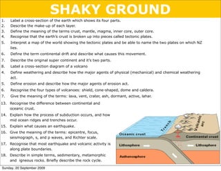
13. Recognise the difference between continental and
oceanic crust.
14. Explain how the process of subduction occurs, and how
mid ocean ridges and trenches occur.
15. Explain what causes an earthquake.
16. Give the meaning of the terms: epicentre, focus,
seismograph, s, and p waves, and Richter scale.
17. Recognise that most earthquake and volcanic activity is
along plate boundaries.
18. Describe in simple terms, sedimentary, metamorphic
and igneous rocks. Briefly describe the rock cycle.
Sunday, 20 September 2009
2. LAYERS - labelling & describing
Demo: The Scotch egg model of the earth’s structure Imagine a Scotch egg......
1. (breadcrumbs)
2. (sausagemeat)
3. (egg white)
4. (egg yolk)
Research - The earth’s structure http://www.windows.ucar.edu/tour/link=/earth/Interior_Structure/
interior.html
Diameter = ________ km. The inner core is so ___ that it causes
material in the outer core and ___________to move around.
_____________
____________ thin silicate rock material
___________
mostly solid (semi-liquid/plastic) and
_________ consisting of
________ _________
liquid and consisting of
________ & _________
solid and consisting of ________ &
_________
Sunday, 20 September 2009
3. HOW THICK ARE YOU??
Study the diagram carefully.
It shows the earth’s layers.
The depth in kilometres of the
boundaries between layers is
shown.
1. Put the thickness of the
layers in order from
thickest to thinnest.
2. A calculator may help.
Thickest layer
____________
____________
____________
Thinnest layer ____________
Sunday, 20 September 2009
4. LAYERS - defining them
Research - Definitions http://mediatheek.thinkquest.nl/~ll125/en/struct.htm
Use the URL above to match the definition with the term with the
composition with the thickness and with the average temperature
Thickness Average
Term Definition Composition
(km) temp (oC)
A. The layer above 1. Iron and Nickel. Extremely hot but (a) 2200 (i) 4500
Inner the core but below the pressure is low enough to allow it
core the crust to exist as a liquid.
B. The earth’s hard 2. Compounds of silicon, iron and (b) 15 (ii) 20
outer shell (which magnesium
Outer floats on the softer to
core part of the mantle)
870
C. The liquid layer 3. Rocks: Basalt and Granite (c) 1250 (iii) 3700
that surrounds and
Mantle spins around the
inner layer
D. The solid, 4. Iron and Nickel. Extremely hot but (d) 2900 (iv) 2600
innermost part of under too much pressure to exist as a
Crust
the earth liquid.
Sunday, 20 September 2009
5. UN-MIXING THE TABLE
Answers Inner core ____ ____ ____ ____
Outer core ____ ____ ____ ____
Mantle ____ ____ ____ ____
Crust ____ ____ ____ _____
Now write the correct definitions for Inner core, Outer core, Mantle and Crust in the
space provided (below):
Definitions
The inner core is ______________________________________________________
____________________________________________________________________
The outer core is ______________________________________________________
____________________________________________________________________
The mantle is ________________________________________________________
____________________________________________________________________
The crust is __________________________________________________________
____________________________________________________________________
Sunday, 20 September 2009
6. CONTINENTAL DRIFT
The tectonic plates that make up the lithosphere
float on the magma of the mantle. Hot magma
near the outer core rises up towards the crust.
When it gets there it cools enough to return to the
core where it can be heated again and the cycle
continues. This cycle results in circular currents
called convection currents. Continental drift occurs
when convection currents cause the tectonic plates
to move.
Practical MODELLING CONVECTION CURRENTS
Method Tea leaves
1. Set up the equipment as shown. xxxxxxxxxxxxxxx
2. As you gently heat the beaker
(using a blue flame) record your Bunsen
observation of how the tea burner
leaves move in the space below. Mat
Observation
____________________________________________________________________
____________________________________________________________________
____________________________________________________________________
Sunday, 20 September 2009
7. TECTONIC PLATES
A closer look at the crust:
Lithosphere
Stiffer part of the
Athenosphere outer mantle and crust
Liquid part of (floats on the
the outer mantle athenosphere)
The lithosphere is broken up into sections called tectonic plates.
It is these plates that can float on the athenosphere
Clickview video: Geography > “Global tectonics, Competing theories > Tectonic
Plate Theory”
Sunday, 20 September 2009
9. CRUST MOVEMENT
A ________________ boundary occurs where the
lithospheric plates move away from each other
Divergent boundaries form ____ - _________ ridges.
The mid - Atlantic ridge is an example of a divergent
plate boundary.
A _________________ boundary occurs when the
lithospheric plates move towards each other.
Oceanic Oceanic
If both plates are continental then the collision will
result in ___________ formation. Continental Continental
The Himalayan mountains are an example of a
convergent boundary.
When an oceanic plate moves towards a continental
plate the heavier oceanic plate slides under the lighter
continental plate. This is called a ____________ zone.
A subduction zone is an area of intense activity. Continental
_________, __________ eruptions and ___________
building all take place in a subduction zone.
The Andes is a result of subduction
Oceanic
Words
volcanic, mountain, divergent, convergent, mountain, subduction,
mid, oceanic, earthquakes,
Sunday, 20 September 2009
10. CRUSTS - continental and oceanic
Oceanic crust Continental crust
About 5 to 10 km thick about 30 to 70 km thick
Consists mainly of heavy rocks like basalt Consists mainly of lighter rocks like granite
Density: 3g per cubic centimetre Density: 2.8g per cubic centimetre
Using the words “thinner, heavier, basalt and granite” describe the difference
between the oceanic and continental crust.
____________________________________________________________________
____________________________________________________________________
Sunday, 20 September 2009
11. RIDGES - a closer look
Ridge Trench Ridge
Continental Plate
Oceanic Plate Oceanic Plate
SPREADING
SUBDUCTION
Magma rises --> cools and expands when it contacts the
ocean --> pushing of the oceanic plates apart --> Ridge
formation as the magma piles up on the edge of each plate
Study the diagrams carefully and use them to write a few sentences which explain how
mid-ocean ridges and trenches are formed:
Sunday, 20 September 2009
12. TECTONIC PLATES - mapped out
The result of the cut & paste exercise
New Zealand lies on two tectonic plates.
Shade each plate carefully using a different colour
Sunday, 20 September 2009
13. THE ORIGINAL SUPER CONTINENT
Reading about it: http://kids.earth.nasa.gov/archive/pangaea/Pangaea_game.html
180 Million Years Ago
About 180 million years ago the supercontinent Pangea began to break up. Scientists believe that Pangea broke apart for
the same reason that the plates are moving today. The movement is caused by the convection currents that roll over in the
upper zone of the mantle. This movement in the mantle causes the plates to move slowly across the surface of the Earth.
About 200 million years ago Pangaea broke into two new continents Laurasia and Gondwanaland. Laurasia was made of
the present day continents of North America (Greenland), Europe, and Asia. Gondwanaland was made of the present day
continents of Antarctica, Australia, South America. The subcontinent of India was also part of Gondwanaland. Notice that
at this time India was not connected to Asia. The huge ocean of Panthalassa remained but the Atlantic Ocean was going to
be born soon with the splitting of North America from the Eurasian Plate.
How do we know that South America was attached to Africa and not to North America 180 million years ago?
Scientists today can read the history of the rock record by studying the age and mineral content of the rocks in a certain
area.
The Triple Junction was formed because of a three-way split in the crust allowing massive lava flows. The split was
caused by an upwelling of magma that broke the crust in three directions and poured out lava over hundreds of square
miles of Africa and South America.
The rocks of the triple junction, which today is the west central portion of Africa and the east central portion of South
America, are identical matches for age and mineral make up. In other words the rocks in these areas of the two
continents were produced at the same time and in the same place. This tells us that South America and Africa were
connected at one time!
Today these two continents are separated by the Atlantic Ocean which is over 2000 miles wide!
Sunday, 20 September 2009
14. 135 Million Years Ago
About 135 million years ago Laurasia was still moving, and as it moved it broke up into the continents of North America,
Europe and Asia (Eurasian plate). Gondwanaland also continued to spread apart and it broke up into the continents of
Africa, Antarctica, Australia, South America, and the subcontinent of India. Arabia started to separate from Africa as the
Red Sea opened up.
The red arrows indicate the direction of the continental movements. Notice how far the Indian subcontinent has to move
to get to its present position connected to Asia.
The Atlantic, Indian, Arctic, and Pacific Oceans are all beginning to take shape as the continents move toward their
present positions.
The plates are still moving today making the Atlantic Ocean larger and the Pacific Ocean smaller. The yellow arrows on
the world map indicate the direction of plates movements today.
Notice the position of the Indian Subcontinent today. It moved hundreds of miles in 135 million years at a great speed (4
inches per year!!!) The Indian plate crashed into the Eurasian plate with such speed and force that it created the tallest
mountain range on Earth, the Himalayas! What do you predict the world will look like in 100 million or 200 million
years? What new mountain ranges will form? Where will new volcanoes erupt?
The Atlantic Ocean will be much larger 50 million years from now and the Pacific Ocean will be much smaller. North and
South America will have moved farther west (California moving north) while Greenland will be located farther west but
also farther north. The western part of Africa will rotate clockwise and crash into Europe causing great mountain
building, while the far eastern region of Africa will rotate eastward toward the Arabian peninsula. Australia will move
farther north into the tropics, while New Zealand will move to the south of Australia.
All of these predictions are just that, predictions. These movements of the continents may happen if the plates continue to
move in the same direction and with the same speed as they are moving today. Scientists are not certain of the movement
today, let alone 50 million years into the future.
What do you think the world will look like in 50 million years???
Sunday, 20 September 2009
15. SUPER CONTINENTS
1. After reading “THE
ORIGINAL
SUPERCONTINENT”. cut
and paste these
pictures into your book
in chronological order.
2. Label your pictures with
how many years ago
the situation existed
3. Answer the questions
that follow.
Sunday, 20 September 2009
16. Questions THE ORIGINAL SUPER CONTINENT
1. What is the name of the original super continent?
2. Why did this continent break up into smaller continents?
3. Describe the countries that are contained within Laurasia and Gondwanaland.
4. Explain how the triple junction was formed?
5. Describe the events that led to the formation of the triple junction.
6. What evidence do scientists have for the theory of continental drift illustrated
by your pictures?
Answers
1. Pangea
2. The movement was caused by convection currents that rolled over the upper zone
of the mantle.
3. Laurasia consists of North America, Asia and Europe. Gondwanaland contains,
South America, Africa, Arabia, Antartica, India and Australia.
4. The triple junction was caused by an upwelling of magma that caused a three way
split in the crust. The crust split off in three different directions to form the
continents South America, Africa/Arabia and Antarctica. The lava poured over large
areas of Africa and America.
5. Scientists study the age and mineral content of rocks in the different continents
and look for similarities (indicating that they could once have been part of the
same land mass.
Sunday, 20 September 2009
17. WORD LIST
Magma reservoir
Ash cloud
Sill
Vent
Throat
Summit
Base
Flank
Lava
Crater
Conduit
Dike
Ash
Parasitic cone
Sunday, 20 September 2009
18. ANSWERS TO THE CUT & PASTE VOLCANO
Sunday, 20 September 2009
19. Slideshow: Volcanoes Presentation VOLCANO TYPES Conc. H2SO4 + Sugar
WHILE YOU WATCH THE SLIDE SHOW, LISTEN CAREFULLY and
Match the volcano type with its description and the drawing of
its shape
1. 1. SHIELD 2. COMPOSITE 3. RHYOLITE 4. CALDERA
CONE OR DOME
(ANDESITE)
(i)
Steep
slopes (ii)
Shallow (iii)
forms a (iv)
cone
slopes
lake
shaped
(a) (b) (c) (d)
2. Which volcano would be the most explosive? ___________________
3. Explain the shape of the shield volcano? __________________________________
__________________________________________________________________
Sunday, 20 September 2009
20. Choose from the word list (right)
to complete the sentences
(below)
Continental
Oceanic plate plate
(Heavier) (Lighter)
Subduction zone
4. When an ___________ plate collides with a continental plate WORD LIST
the ___________ plate goes under the ____________ plate.
rocks
This happens because the _______________ is ___________. extinct
5. As it goes under, the higher temperature of the mantle melts it volcano
and the magma rises up through cracks as ________. This is lava
how a _________ is formed. oceanic
steam
6. Five things that pour out of a volcano during an eruption are active
___________ , ___________ , ____________ , ___________ dust
and ______________ . continental
dormant
7. An _________ volcano is one that is erupting. heavier
8. A sleeping volcano is called a ______________ volcano. It has crust
not erupted for many years but may erupt at any time. ash
9. A dead volcano is called an _____________ volcano .
Sunday, 20 September 2009
21. The Taupo volcanic zone includes volcanoes in the
central North Island, Rotorua and the Bay of
Reading about volcanoes Plenty. These volcanoes lie along the edge of the
Pacific and Indo-Australian plates. Because the
oceanic crust of the Pacific plate is sliding under
the Indo-Australian plate, volcanic activity is seen
on the continental crust of the Indo-Australian
plate parallel to the plate boundary.
There are different volcano types in the Taupo
volcanic zone. This is because the different volcano
types are created from magma from different
depths along the subduction zone. The thickness of
magma (how easily it flows) depends on its depth
and temperature.
Basalt volcanoes are formed from the eruption of
thin, runny magma which comes from deep
along the subduction zone where the temperature
is high. This magma also has a low silica
content.
Taupo
Volcanic
Zone
Sunday, 20 September 2009
22. Silica thickens the magma and since the silica content is low the magma that forms basalt volcanoes is thin
and runny. The magma that escapes from the crust to form a Basalt volcano is basic (the opposite to being
acidic) and the eruptions that form the slopes of the volcano are mild.
At the other extreme, if the magma comes from a shallow region of the subduction zone, where the
temperature is much lower, Rhyolite volcanoes are formed. This magma which is at a lower temperature
also has a high silica content and is therefore thicker and reluctant to flow easily. The magma is acidic.
This results in steep sided volcanoes like Mount Tauhara and Mount Maunganui. These mountains were formed
by violent eruptions. Lake Taupo was originally a rhyolite dome volcano. Pressure under the mountain rapidly
dropped after a violent explosion which caused the crust to collapse. This formed a caldera. The explosion was
so violent that the ash turned the sky red over Rome and China. The crater that remained filled with water to
form a large lake.
Andesite volcanoes are formed from magma which has a thickness, silica content and acidity which is
somewhere between the basic magma of basalt volcanoes and the acidic magma of rhyolite volcanoes.
Sunday, 20 September 2009
23. VOLCANO TYPES
Once you have completed the reading, complete the summary
table below:
2.COMPOSITE
3.RHYOLITE
1.SHIELD CONE OR 4.CALDERA
DOME
(ANDESITE)
Sketch
(showing the
shape)
Eruption type
Thickness of
the magma
Silica content
A NZ example
Sunday, 20 September 2009
24. A SUMMARY
Lava is ___________and Lava is ___________and
slow-cooling so it cools ________so it is
spreads out more before not able to spread out as
it solidifies far before it solidifies
Pressure drops in
the mantle so the
lithosphere collapses
Lava is ___________and cools __________ so it is
not able to spread out as far before it solidifies
Sunday, 20 September 2009
25. What
has caused these
changes?
Sunday, 20 September 2009
26. What
has caused these
changes?
WAVE ACTION
Sunday, 20 September 2009
27. What
has caused these
changes?
WAVE ACTION
STREAM ACTION
Sunday, 20 September 2009
28. What
has caused these
changes?
WAVE ACTION
STREAM ACTION
WAVE ACTION
Sunday, 20 September 2009
29. What
has caused these
changes?
EARTH
MARS
Sunday, 20 September 2009
30. What
has caused these
changes?
EARTH
MARS
BOTH CAUSED BY WIND
Sunday, 20 September 2009
31. What
has caused these
changes?
Sunday, 20 September 2009
32. What
has caused these
changes?
ICE AND ROCKS,
FALLING UNDER THE
INFLUENCE OF GRAVITY
Sunday, 20 September 2009
33. What
has caused these
changes?
Sunday, 20 September 2009
34. What
has caused these
changes?
ALTERNATING HEATING
AND COOLING
Sunday, 20 September 2009
35. What
has caused these
changes?
Sunday, 20 September 2009
36. What
has caused these
changes?
PLANT ROOTS
GROWING INTO THE
ROCK
Sunday, 20 September 2009
37. What
has caused these
changes?
Sunday, 20 September 2009
38. What
has caused these
changes?
ACID RAIN
Sunday, 20 September 2009
39. What
has caused these
changes?
When marble contains sulphide minerals and undergoes oxidation, the Iron II will produce rust spots, and the sulfur is converted to
sulphuric acid, which can dissolve calcium. During oxidation Iron II is converted to Iron III.
Sunday, 20 September 2009
40. What
has caused these
changes?
CHEMICAL WEATHERING
(CALLED OXIDATION)
When marble contains sulphide minerals and undergoes oxidation, the Iron II will produce rust spots, and the sulfur is converted to
sulphuric acid, which can dissolve calcium. During oxidation Iron II is converted to Iron III.
Sunday, 20 September 2009
41. Frost Wedging (or Freeze - Thaw)
There often needs to be a repetitive cycle of
freezing and thawing (melting)
Glaciers
Weathering takes place in glaciers but not by
the action of frost because the water is not
freezing and thawing so regularly. Instead
_____________________________________
_____________________________________
_____________________________________
This is the Fox Glacier in New Zealand. The sheet of ice is constantly moving down the mountain side,
breaking off rock as it goes and carrying those pieces down the valley.
Sunday, 20 September 2009
42. WEATHERING SUMMARY
Weathering is the process by which rocks are broken down.
Weathering can be Mechanical or chemical.
Mechanical weathering
• Water can dissolve soluble rock or wear away insoluble rock through the action of
waves, streams or rainfall.
• Wind blows pieces of sand over rocks, wearing away softer rock
• Ice and rocks falling under the influence of gravity can wear away the sides of
mountains forming valleys.
• Alternating heating and cooling can break down rocks over time because the rock
contains different materials that expand differently. This forces the materials apart
and causes the rock to be broken down into smaller pieces.
• Frost action can break up rocks because when water freezes in cracks it expands,
forcing the rock to split.
• Plant roots can grow in rocks and as they do so they can break the rock up into
smaller pieces.
Chemical Weathering
• Acid rain reacts with the calcium in rocks causing them to break down.
• Oxidation occurs when the iron sulphide minerals in marble react with oxygen to
form rust.
Sunday, 20 September 2009
43. EROSION AND ITS AGENTS
Erosion is the transportation of rock, soil, and mineral particles. It is this
transportation that causes material to be worn away. Erosion and weathering often
occur together
Sources of erosion:
Gravity
Water (running water, glaciers, and rain)
Wind
Waves
EXAMPLES
________________ ________________
Sunday, 20 September 2009
44. EROSION AND ITS AGENTS
Erosion is the transportation of rock, soil, and mineral particles. It is this
transportation that causes material to be worn away. Erosion and weathering often
occur together
Sources of erosion:
Gravity
Water (running water, glaciers, and rain)
Wind
Waves
EXAMPLES
________________ ________________
Sunday, 20 September 2009
45. Type of weathering (Mechanical/Chemical/Biological)
A
B
C
D
E
1.Copy this table into
F the back of your
G
H
book.
I 2.Complete it as you
J
K
view the slides
L which follow
M
N
O
P
Sunday, 20 September 2009
62. Type of weathering - Answers
A Mechanical (wind)
B Mechanical (water)
C Mechanical (Freeze - thaw)
D Chemical weathering (acid rain)
E Mechanical (Alternate heating & cooling)
F Mechanical (Gravity causing Glaciers to scour out valley)
G Chemical (acid rain)
H Mechanical (Gravity causing Glaciers to scour out valley)
I Biological weathering
J Mechanical (Alternate heating & cooling)
K Mechanical (Wave action)
L Chemical weathering
M Biological weathering
N Chemical weathering (acid rain)
O Biological weathering
P Biological weathering
Sunday, 20 September 2009
63. Study the pictures (below) and for each picture state the source/s of erosion
responsible for the observed changes. Explain how the changes occurred
Farmland
_______________________________________________________
_______________________________________________________
_______________________________________________________
_______________________________________________________
_______________________________________________________
_______________________________________________________
_______________________________________________________
Desert rocks
_______________________________________________________
_______________________________________________________
_______________________________________________________
_______________________________________________________
Mountain slopes
_______________________________________________________
_______________________________________________________
_______________________________________________________
_______________________________________________________
Stream _______________________________________________________
Sunday, 20 September 2009
64. EARTHQUAKES - causes
An earthquake is a vibration of the earth caused by a rapid release of energy.
Earthquakes are commonly caused by subduction where there is friction
(between the oceanic and the continental plate) which is suddenly released.
New Zealand has many earthquakes because it is situated over subduction zones.
These are often called faults but aren’t. A fault is where the plates crash into
each other without either plate sliding under the other. Faults can also cause
earthquakes.
1. Either read p112 & 113 (Pathfinder 10) or research earthquakes on the internet.
2. Complete the following definitions
Epicentre ___________________________________________________________
Focus ___________________________________________________________
Seismograph ________________________________________________________
s waves ________________________________________________________
p waves ________________________________________________________
Richter scale _________________________________________________________
• The Taupo-Rotorua “fault” causes the Bay of Plenty Earthquakes.
• There are 2 types of earthquake waves: P and S.
• A seismometer can pick up these waves. This produces a seismogram:
P waves arrive first, S waves arrive later. The time difference tells us how far away the
quake is Mini assignment - “Reading the traces” from Wignall and Wales (Y10 Homework Book)
Sunday, 20 September 2009
65. THE ALPINE FAULT - forming the Southern Alps
Sunday, 20 September 2009
66. READING ABOUT IT
Over the past 25 million years, the land either side of the alpine fault moved vertically
creating the Southern alps (which are about 4 km high)
The amount of uplift that has occurred is much greater than 4km (some estimates
put it at 20 km)
The height has been kept down due to weathering and erosion
In South Island two continental crusts, the
Indo-Australian and the Pacific plate crash
into each other. Of course, where the plates
meet, rocks crash (very slowly) together with
tremendous power. Folding (bending) and
faulting (fracturing, breaking) of rocks occur.
Faulting and folding lead to mountain
building .
The southern alps
Mountain building occurs
Continental Continental
Mantle
Sunday, 20 September 2009
67. PUTTING EARTHQUAKES ON THE MAP Cut & Paste
Most earthquakes in New Zealand occur along
the main ranges living from Fiordland in the
southeast to East Cape in the northwest. This
axis follows the boundary between the Indo-
Australian and Pacific plates. Large
earthquakes are less common along the
central Alpine Fault, where the plates are not
subducting and the forces are accommodated
in different ways.
The largest city within this high risk zone is the
nation's capital, Wellington, followed by
Napier and Hastings. All these cities have
nch
experienced severe earthquakes since
ng i tre
European settlement. ura
Hik
After reading the above
paragraphs, put the locations
(in bold print, on the map)
Sunday, 20 September 2009
68. ROCK TYPES AND THE ROCK CYCLE
http://www.windows.ucar.edu/tour/link=/earth/geology/rocks_intro.html
When a volcano erupts, the magma reaches the surface as lava. Lava cools to form
rocks called igneous rocks. Igneous rocks contain crystals which are the result of the
cooling process. When lava cools quickly, the crystals are small (as they are in
basalt). Osidian is an exception. It cools rapidly but without crystal growth. Air can
also be trapped in the lava as it cools rapidly (to form rocks like pumice or scoria).
Slow cooling results in larger crystals to produce rocks like granite.
Over time igneous rocks are eroded and the particles (sediments) collect in rivers and
oceans. This material is buried and compacted to form sedimentary rocks (such as
sandstone and mudstone). Sedimentary rocks can be recognised from the existence
of particles such as sand, mud and pebbles. Sedimentary rocks allow scientists to
learn about the environment that existed when the layers were formed. Fossils are
evidence of living things trapped in the sediments before they became rocks.
Scientists can also learn about climate change from these layers.
Sedimentary rock that finds itself in deeper, hotter regions of the crust can change
into metamorphic rocks. Metamorphic rocks are formed from sedimentary rocks that
have been subjected to heat and pressure. This occurs in places where tectonic plates
are coming together.
When metamorphic rocks melt they become part of the magma. This leaves
volcanoes as lava which cools to form igneous rocks and the cycle continues.
Sunday, 20 September 2009
69. SORTING OUT THE ROCK CYCLE
Cut & paste the picture (below) into your book. Choose
from the labels (right) to complete the flow chart.
• Melting
• Deposition of
sediment
• Burial &
compaction
• Erosion &
transport
• Weathering of
rocks at
surface
• Crystallisation
of magma
• Deformation &
metamorphism
Sunday, 20 September 2009
70. SORTING OUT THE ROCK CYCLE
Cut & paste the picture (below) into your book. Choose
from the labels (right) to complete the flow chart.
• Melting
• Deposition of
sediment
• Burial &
compaction
• Erosion &
transport
• Weathering of
rocks at
surface
• Crystallisation
of magma
• Deformation &
metamorphism
Sunday, 20 September 2009
71. A
For this rock and the rocks on the next few slides, try to figure out what type
of rock it is
Sunday, 20 September 2009
84. ROCK TYPE - answers
A Metamorphic
B Igneous
C Metamorphic
D Igneous
E Sedimentary
F Sedimentary
G Metamorphic
H Metamorphic
I Igneous
J Sedimentary
K Igneous
L Metamorphic
M Sedimentary
Sunday, 20 September 2009
85. Red rock canyon, las Vegas. The gray
mountains are limestone and the red and
white hills are sandstone.
Blocks of marble, a
metamorphic rock, are cut
from a quarry in Carrara, Italy.
Metamorphic rock, Kaikoura.
Sunday, 20 September 2009
86. the San Andreas Fault zone which exhibits 1500km of
movement in about 10 million years, as the North
American Plate has slid to the northwest relative to the
Pacific Plate.
Sunday, 20 September 2009
87. Revision questions WEATHERING & EROSION
Over time ___________ smooths mountains and reduces their height.
__________ weathering breaks down rock into smaller pieces whereas chemical
________ breaks rocks down into simpler substances.
Mechanical weathering can occur in a range of ways:
• ________ carries sand that scours rocks
• ________ washes rocks down rivers where they break up
• ________ in cracks in rocks which freezes, expands and split rocks
• ________ roots grow in cracks, grow and split rocks
Chemical weathering also has a range of causes
• Oxygen reacts with ________ in the rock, breaking them down
• _________ slowly dissolves rocks
• _________ in rain dissolves rock especially carbonate
After rocks have been broken down by weathering. Rocks move from the
mountains towards the sea in a process called _________. Moving air (i.e.
______) can carry small particles. Massive ice fields (____________) move rocks
along with them. Most erosion however is carried out by ____________
Word List wind water water erosion
chemical mechanical glaciers acid transportation
metals plant wind water water
Sunday, 20 September 2009
88. Answers WEATHERING & EROSION
Over time ___________ smooths mountains and reduces their height.
__________ weathering breaks down rock into smaller pieces whereas chemical
________ breaks rocks down into simpler substances.
Mechanical weathering can occur in a range of ways:
• ________ carries sand that scours rocks
• ________ washes rocks down rivers where they break up
• ________ in cracks in rocks which freezes, expands and split rocks
• ________ roots grow in cracks, grow and split rocks
Chemical weathering also has a range of causes
• Oxygen reacts with ________ in the rock, breaking them down
• _________ slowly dissolves rocks
• _________ in rain dissolves rock especially carbonate
After rocks have been broken down by weathering. Rocks move from the
mountains towards the sea in a process called _________. Moving air (i.e.
______) can carry small particles. Massive ice fields (____________) move rocks
along with them. Most erosion however is carried out by ____________
Answers - listed left to right
erosion mechanical chemical wind water
water plant metals water acid
transportation wind glaciers water
Sunday, 20 September 2009
89. HOW WE LEARNT ABOUT THE EARTH’S LAYERS
If it were possible to drill a hole to the center of the Earth, about 2,900 km below the surface the drill
bit would reach the Earth's core. First the drill would bore through the solid, relatively low density rock
of the crust. Then anywhere from 7 to 50 km below the surface the bit would encounter the much
denser rock of Earth's mantle. Finally it would reach the core, which consists of an outer molten layer
beginning at about 2,900 km and then an inner solid crystalline mass starting at about 5,100 km.
Sometimes called the centrosphere, or the Earth's innermost layer, the core was almost a complete
mystery until the development of the science of seismology and seismic instruments. Seismographs
reveal the nature of the vibrations, or seismic waves, produced during an earthquake. As seismologists
learned more about seismic waves, they realized they could use them to interpret the density and
structure of the Earth's interior.
In 1897, a discovery by the Irish scientist Richard Dixon Oldham provided early clues about the nature
of Earth's interior. He found that (seismic) waves generated by explosions or earthquakes travel through
the interior of the Earth in different directions and at different speeds.
The two basic types of seismic waves discovered by Oldham are known as body waves--those that move
through the Earth's interior, and surface waves - those that travel only along the surface. There are two
kinds of body waves: primary and secondary waves. Primary or P waves, cause compressional
movement emanating from the source of the disturbance. Secondary or S waves, produce shear motion
in a direction perpendicular to the P wave. While P waves can pass through gases, liquids, and solids, S
waves can only penetrate through solid matter.
Seismic waves have also helped scientists learn the various densities of the Earth's many layers because
the speed of primary shock waves moving through the Earth generally increases with depth. This is
because as density increases, seismic wave velocity increases. While P-waves travel through the Earth's
crust at an average of about 6.4 km per second, they reach an average of 11.3 km per second at the
center of the Earth. When the shock waves suddenly shift in direction and speed, scientists are able to
determine the depths at which Earth's various layers are located.
Sunday, 20 September 2009
90. HOW WE LEARNT ABOUT THE EARTH’S LAYERS
If it were possible to drill a hole to the center of the Earth, about 2,900 km below the surface the drill
bit would reach the Earth's core. First the drill would bore through the solid, relatively low density rock
of the crust. Then anywhere from 7 to 50 km below the surface the bit would encounter the much
denser rock of Earth's mantle. Finally it would reach the core, which consists of an outer molten layer
beginning at about 2,900 km and then an inner solid crystalline mass starting at about 5,100 km.
Sometimes called the centrosphere, or the Earth's innermost layer, the core was almost a complete
mystery until the development of the science of seismology and seismic instruments. Seismographs
reveal the nature of the vibrations, or seismic waves, produced during an earthquake. As seismologists
learned more about seismic waves, they realized they could use them to interpret the density and
structure of the Earth's interior.
In 1897, a discovery by the Irish scientist Richard Dixon Oldham provided early clues about the nature
of Earth's interior. He found that (seismic) waves generated by explosions or earthquakes travel through
the interior of the Earth in different directions and at different speeds.
The two basic types of seismic waves discovered by Oldham are known as body waves--those that move
through the Earth's interior, and surface waves - those that travel only along the surface. There are two
kinds of body waves: primary and secondary waves. Primary or P waves, cause compressional
movement emanating from the source of the disturbance. Secondary or S waves, produce shear motion
in a direction perpendicular to the P wave. While P waves can pass through gases, liquids, and solids, S
waves can only penetrate through solid matter.
Seismic waves have also helped scientists learn the various densities of the Earth's many layers because
the speed of primary shock waves moving through the Earth generally increases with depth. This is
because as density increases, seismic wave velocity increases. While P-waves travel through the Earth's
crust at an average of about 6.4 km per second, they reach an average of 11.3 km per second at the
center of the Earth. When the shock waves suddenly shift in direction and speed, scientists are able to
determine the depths at which Earth's various layers are located.
Sunday, 20 September 2009
91. In 1906, Oldham recognized the existence of the Earth's core and made a preliminary, but incorrect,
estimate of its size. He also noted a seismic "shadow zone," on the side of the Earth opposite the
earthquake, where no P waves were recorded. Although uncertain, he presumed this resulted from
refraction, or bending of waves, similar to light passing through a glass lens. In 1926, British
seismologist Harold Jeffreys recognized an S wave shadow zone that begins 103 degrees from an
earthquake and forms a "bullseye" shaped shadow on the backside of the Earth where no S waves are
recorded. This indicated that the core was molten, since shear waves cannot pass through liquids.
Oldham's work, which included partially successful attempts to determine the existence of a thin outer
crust and an inner core, helped other scientists accurately map the Earth's different layers. In 1909,
Andrija Mohorovicic (1857-1936) published important findings from his study of an earthquake that hit
Croatia. Based on his analysis of P and S wave speeds and arrival times, he was able to calculate the
depth of the boundary where material changes from the Earth's crust to its mantle. This important
discovery resulted in his name being applied to that boundary, called the Mohorovicic discontinuity, or
the Moho for short. In 1914, based on seismic wave studies, Beno Gutenberg estimated the diameter of
the core to be about 4,375 mi (7,000 km), a figure that still stands today. In tribute to that discovery,
the boundary where the mantle and the core meet is referred to as the Gutenberg Discontinuity.
In 1936, Danish seismologist Inge Lehmann hypothesized the existence of an inner core within the
Earth's deepest interior, based on receipt of weak P waves in the P shadow zone and presented her
arguments using elementary trigonometry. She believed that by passing through the boundary from an
outer core to an inner core, P waves could be refracted and received within the P wave shadow zone. For
the next two years, Gutenberg and Charles F. Richter (1900-1985) worked on the problem and helped
confirm Lehmann's hypothesis that the core had both an inner and an outer shell. The size of the inner
core, however, and whether it was solid, liquid, or a mixture of both could not be established at that
time. Further studies during the 1940s by K.E. Bullen showed that the inner core was solid, while the
outer core was liquid. This change in phase probably results from the immense pressures at this depth.
Sunday, 20 September 2009
92. Unlike the rock of Earth's mantle and crust, the core is thought to be composed almost entirely of metal,
largely iron in the outer core, with an alloy of iron and nickel in the inner core. It is, of course,
impossible to sample the core directly. What are believed to be minute inclusions of mantle material are
sometimes found in diamonds, as well as from other sources; however, no such fragments of the Earth's
core have ever been found, nor are they ever likely to be. Instead, geologists have had to find another
source for study. Planetary geologists believe that Earth formed from material very similar to that of
meteorites. Stony meteorites are considered to be representative of the mantle, while iron meteorites
are representative of the core. Therefore, geologists base their estimates of the composition of the
Earth's core on studies of meteorites.
In 1996 researchers Xiaodong Song and Paul Richards of the Lamont-Dougherty Earth Observatory
discovered that the inner core rotates freely within the low viscosity fluid of the outer core. The finding
confirmed what seismologists had suspected for years: the highly fluid iron of the outer core allowed the
inner core to move independently of the rest of the Earth. They discovered this by noting that on
seismic records for earthquakes from different years, P waves following the same path through the inner
core had different travel times. These waves must be traveling along different paths through the inner
core, a result of its rotation. In addition, they determined that the inner core rotates about one-quarter
turn faster than the crust and mantle each century, or about one degree faster per year. Computer
models suggest this is due to two jet stream-like currents flowing through the outer core. These carry a
magnetic field that "tugs" on the inner core and gives its rate of rotation an extra "boost." Later that
same year other researchers confirmed their findings.
Answer the following questions in the BACK OF YOUR BOOK
1. Describe how early knowledge of the earth’s structure was gained.
2. Name the two types of waves that scientists studied in order to learn about the
earth’s structure.
3. How did scientists discover that the inner outer core was molten?
4. Where did scientists get clues from about the composition of the core?
Sunday, 20 September 2009
93. KEY WORDS 4 THE TOPIC Word Search
mantle
crust D Z G G S N C F W U E Z C Q E
crater
epicentre A O D N B A O K E C R A T E R
core
weathering
E R R Q T C I I A T Y K J S O
dormant L A E M C N O I T C U D B U S
focus
erosion
T C C D A O E R H C B V Y C I
volcano N C Y T L N N V E O E V C O O
active
seismograph
A E B C I A T T R T O V V F N
shield M R E I Z V C G I K S O N Z K
cone
lahar C T U E B U E Y N N L U L O D
Richter H N L A H A R F G C E Q R O C
dome
caldera S E I S M O G R A P H N M C T
tectonic C C T E C T O N I C H E T O V
lava
vent O I A V A L O D L E I H S A P
subduction N P S P R E T H C I R W I P L
convection
continental E E E V U I W K I A D U V B P
Sunday, 20 September 2009
94. MAKING A GLOSSARY 1
WORD Ans Definition
1. Mantle A. powdery material thrown out of a volcano
2. Crust B. describes a cone-shaped volcano
3. Core C. Outer, thin layer of the earth consisting of rocky material
4. Lava D. hole in the earth’s crust where an eruption may occur
5. Vent E. has not erupted for a long time but can erupt
6. Crater F. describes a volcano which has erupted violently to form a huge
hollow which can fill with water to become a lake
7. Ash G. describes a volcano which has shallow slopes
8. Lahar H. a mountain which has a vent through which material from the
mantle can be ejected
9. Dormant I. magma that has cooled above the surface
10. Active J. describes a volcano that has steep slopes
11. Volcano K. mud flow
12. Shield L. thick layer of semi-liquid rock
13. Cone M. central part of the earth, inner core is solid, outer is liquid
14. Dome N. currently erupting
15. Caldera O. a large cavity forming the mouth of a volcano
Sunday, 20 September 2009
95. MAKING A GLOSSARY 2
WORD Ans Definition
1. Lithosphere A. describes the crust underlying the continents
B. point on the earth’s surface above the focus of an
2. Asthenosphere
earthquake
3. Subduction C. breaking down of rocks on the earth’s surface
4. Convection D. transport of rock fragments and other material
5. Continental E. upper mantle below lithosphere made of plastic rock
6. Oceanic F. Sinking of one tectonic plate edge below another
7. Erosion G. point where an earthquake starts
8. Weathering H. describes currents formed by the rising of hot, less dense
material
9. Richter I. describes crust underlying the oceans
10. Epicentre J. upper mantle consisting of rigid rock
11. Focus K. instruments which record earthquake waves
12. Seismograph L. plates of lithosphere underlying continents & oceans
13. Tectonic M. scale for measuring the size of an earthquake
Sunday, 20 September 2009
96. THE BIG SHAKY GROUND CROSSWORD
Sunday, 20 September 2009
97. THE BIG SHAKY GROUND CROSSWORD
Sunday, 20 September 2009