Highway presentation
•Download as PPTX, PDF•
18 likes•12,450 views

Bridge and location of bridge, Drawing required for highway project ,Factors affecting selection of Bridge Site,Field survey, etc.

Recommended
More Related Content
What's hot
What's hot (20)
Similar to Highway presentation
Similar to Highway presentation (20)
Recently uploaded
Recently uploaded (20)
Highway presentation
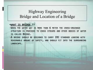
- 1. WHAT IS BRIDGE ?? -WHEN THE WATER WAY IS MORE THAN 6 METER THE CROSS-DRAINAGE STRUCTURE IS PROVIDED TO CROSS STREAMS AND OTHER BODIES OF WATER IS CALLED BRIDGE. -A BRIDGE SHOULD BE DESIGNED TO CARRY IRC STANDARD LOADING WITH REASONABLE AMOUNT OF SAFETY, AND SHOULD FIT INTO THE SURROUNDING LANDSCAPE. Highway Engineering Bridge and Location of a Bridge
- 2. Ideal Location For a Bridge Site A straight reach of a river, so that the piers of the bridge can be located parallel to the direction of flow. There should be steady regime of a river and absence of serious whirls or cross-currents. Availability narrow and well defined channel. Absence of a sharp curve e in approaches, so that Scouring(erosion) and Silting(deposition) action can be prevented.
- 3. Ideal Location For a Bridge Site Preferring reasonable proximity(availability) to the direct alignment of road to be served . Rocky or other compact and non-erodable bed is preferrable.
- 4. Factors affecting selection of Bridge Site Width of a River:- The site at which there is least width of the river is available is suitable for construction of a bridge. A Straight Approach:- Cross-section of a bridge should be straight as far as possible, because a straight bridge is far more stable than a curved bridge. River Banks:- Velocity of the Flow:- The place where the velocity of the water flow is min. considering the width of the river is suitable for bridge cons.
- 5. Factors affecting selection of Bridge Site Free Board:- Absence of Scouring and Silting:- There should be no erosion and deposition of the rock and other materials like sand, silt, gravel, on either side of the river. This can cause a failure to the piers of the bridge.. No confluence of large Tributaries:- Construction of a bridge should be carried out at such a site where no large tributaries of rivers meet.
- 6. Data to be collected for location of a Bridge Site Type of soil:- Necessary information about the soil type and its condition should be collected by the geologist/engineer and should ensure that the soil bed conforms the I.S. for the particular bridge const. Avail. of Electricity:-Ample amount of electricity and its sources and substitutes should be made available in const. of a bridge site. Avail. of Skilled&Unskilledlabours:- Construction of different components of bridge needs different type of labours in considerable amount . Hydrological Data:- Collection of info. about the Rainfall, Run-off, Infiltration by soil, Evaporisation, Velocity of flow etc . Avail. of Const. Material:- More than ample amount of const. material should be available at all time.
- 7. Data to be collected for location of a Bridge Site Possibility of Navigation Facilities:- Navigation of heavy machinery should be possible at site. Possibility of Earthquake:- A site for bridge const. should be least prone to earthquake, and necessary data of past EQ should be collected and acc. to it bridge should be designed. Present and Future Traffic Volume:- The width of a carriage way of bridge should fulfill the traffic requirements of the present and future conditions of the surrounding areas.
- 9. FIELD SURVEY. Before a highway alignment is finalised in highway project, the engineering surveys are to be carried out. And these surveys are carried out in four stages. The first three stages consider all possible alternate alignment i.e. various requirements of highway alignment and fourth stage is meant for detailed survey of the selected alignment.
- 10. STAGES OF ENGINEERING SURVEYS. THE FOUR STAGES OF ENGINEERING SURVEYS:- 1. Mapstudy 2. Reconnaissance 3. Preliminarysurveys 4. Finallocationanddetailedsurveys
- 11. MAP STUDY It is a kind of study of topographic map of an area, so as to suggest the possible routes of the road.The main features like river , hills , valley etc are also shown in this map. By careful study of such maps , it is possible to have an idea of several alternate routes of the road.
- 12. Details from the map. Alignment avoiding valleys , ponds or lakes. In hills , possibility of crossing through a mountain pass. Approximate location of bridge site for crossing rivers. Alternate route with permissible gradient.
- 13. RECONNAISSANCE It is a second stage of surveys and used to examine the general character of the area for deciding the most feasible routes for detailed studies. A field surveyor may inspect a fairly broad stretch of land along the proposed alternative routes of the map in the field.
- 14. OBJECTIVES To obtain general knowledge of the entire territory. To obtain specific information of salient features of the area. To collect information about the soil type along the route. To collect information about sources of construction materials.
- 15. PRELIMINARY SURVEY OBJECTIVES 1. To conduct the survey for alternate alignments propose after reconnaissance. 2. To compare the different proposals in view of the requirement of a good alignment. 3. To collect necessary physical information and details of topography, drainage and soil. 4. To estimate quality of earth work materials.
- 16. Procedure of preliminary survey 1. Primary traverse. The first step in the preliminary survey is to establish the primary traverse following the line recommended in the reconnaissance. 2. Topographical features. All geographical and other man made features along the transverse and for a certain width are surveyed and plotted. 3. Levelling work. Levelling work is also carried out side by side to give the center line profiles and typical cross section. 4. Drainage studies and Hydrological data. Drainage investigations and hydrological data are collected so as to estimate the type, number and approximate size of cross drainage structures.
- 17. 5. SOIL SURVEY It is an essential part of preliminary survey and by help of this survey final location is being decided. 6. MATERIAL SURVEY This survey is done for naturally occurring materials like stone aggregates and identification of suitable quarries. 7. TRAFFIC SURVEY This survey is conducted in the region for deciding the number of traffic lanes and roadway width, pavement design and economic analysis of highway project. 8. DETERMINATION OF FINAL CENTER LINE After completing the preliminary survey and conducting the comparative studies of alternate alignments the final center line of the road is to be decided before the final location survey.
- 18. FINAL LOCATION AND DETAILED SURVEY The alignment finalised after the preliminary survey then detailed survey is carried out for the preparation of plans and construction details. The location survey is carried out in two stages; 1. On paper location 2. Field location 1. On paper location. The final route is put on the drawings and details such as gradient , radius of curves etc are marked clearly. 2. Field location On paper location is transferred to the field within help of transit theodolite and precise level.
- 19. DETAILED SURVEY Temporary bench marks are fixed at the at the interval of 250m. Vertical alignment , earth work and drainage details are worked out from level notes. A detailed soil survey is carried out and soil profile is established. Work on all rivers and valley are surveyed in detail up to considerable distance on either sides.
- 20. DRAWING REQUIRED FOR HIGHWAY PROJECT IN A HIGHWAY PROJECT,THE FOLLING DRAWING ARE REQUIRED:- KEY PLAN INDEX MAP PRELIMINARY SURVEY PLANS DETAILED PALNS LONGITUDINAL SECTION CROSS SECTION LAND ACQUISITION PLANS DEAWING OF ROAD INTERSECTION
- 21. KEY MAP It shows how actually the project has to be done Map showing proposed and existing roads Importatant places to be connected Size of the map should not exceed 240x330mm(A4 size) Scale should be chosen depending upon the area
- 22. INDEX MAP It shows how actully the highway project looks like It shows the general topography of the area Details are symbolically represented Size of the map should not exceed 240x330mm(A4 size) The usual scale is 1cm=0.5km
- 23. PRELIMINARY SURVEY PLANS It shows the details of various alternative alignments It shows all the information collected during preliminaery survey Its size from 240x330mm(A4 size) to 880x1230mm(A0). Scale 10cm=1km
- 24. DETAILED PALNS It shows the ground plan with alignment and boundaries,countour at interval 1 to 2 m in plain country and 3 to 6 m in hilly areas. Size of the drawing may b 625x880 mm It should also the existing structures ,rivers ,physical features ,etc.
- 25. LONGITUDINAL SECTION The Longitudinal section(L-section) should be drawn to a horizontal scale of 1:2000 and a vertical scale of 1:2000 The levels should be taken at 50m intervals for plain and rolling terrain and at 25m interval for hilly terrain. The L-section should have information like chainages ,horizontal and vertical alignment ,datum level ,ground level ,formation level ,depth of cutting ,height of filling ,posiotion of cross-roads etc
- 26. CROSS-SECTION It should be drawn at to nstural scale of 1cm=2- 2.5 m It should be drawn in every 100m or where abrupt changes in level It should include cross-section number,the reduced distances and the area of cutting and filling. In hill roads cross section should be drawn at closer intervals.
- 27. LAND ACQUISITION PLANS It shows the land acquisition details. Generl details like building, wells, nature of gradients and others details required for assessing the values. The scale adpoted may b 1cm=40m or less. Drawing of road intersections should be prepared showing all details of pavement , islands etc.