G43033541
•
0 likes•242 views

International Journal of Engineering Research and Applications (IJERA) is an open access online peer reviewed international journal that publishes research and review articles in the fields of Computer Science, Neural Networks, Electrical Engineering, Software Engineering, Information Technology, Mechanical Engineering, Chemical Engineering, Plastic Engineering, Food Technology, Textile Engineering, Nano Technology & science, Power Electronics, Electronics & Communication Engineering, Computational mathematics, Image processing, Civil Engineering, Structural Engineering, Environmental Engineering, VLSI Testing & Low Power VLSI Design etc.

Recommended
Recommended
More Related Content
Similar to G43033541
Similar to G43033541 (20)
Recently uploaded
Recently uploaded (20)
G43033541
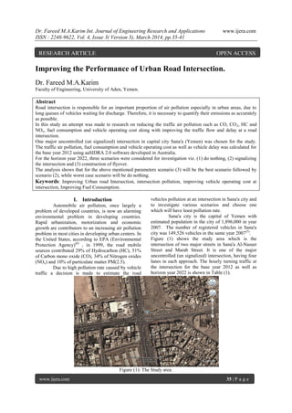
- 1. Dr. Fareed M.A.Karim Int. Journal of Engineering Research and Applications www.ijera.com ISSN : 2248-9622, Vol. 4, Issue 3( Version 3), March 2014, pp.35-41 www.ijera.com 35 | P a g e Improving the Performance of Urban Road Intersection. Dr. Fareed M.A.Karim Faculty of Engineering, University of Aden, Yemen. Abstract Road intersection is responsible for an important proportion of air pollution especially in urban areas, due to long queues of vehicles waiting for discharge. Therefore, it is necessary to quantify their emissions as accurately as possible. In this study an attempt was made to research on reducing the traffic air pollution such as CO, CO2, HC and NOx, fuel consumption and vehicle operating cost along with improving the traffic flow and delay at a road intersection. One major uncontrolled (un signalized) intersection in capital city Sana'a (Yemen) was chosen for the study. The traffic air pollution, fuel consumption and vehicle operating cost as well as vehicle delay was calculated for the base year 2012 using aaSIDRA 2.0 software developed in Australia. For the horizon year 2022, three scenarios were considered for investigation viz. (1) do nothing, (2) signalizing the intersection and (3) construction of flyover. The analysis shows that for the above mentioned parameters scenario (3) will be the best scenario followed by scenario (2), while worst case scenario will be do nothing. Keywords: Improving Urban road Intersection, intersection pollution, improving vehicle operating cost at intersection, Improving Fuel Consumption. I. Introduction Automobile air pollution, once largely a problem of developed countries, is now an alarming environmental problem in developing countries. Rapid urbanization, motorization and economic growth are contributors to an increasing air pollution problem in most cities in developing urban centers. In the United States, according to EPA (Environmental Protection Agency)(6) , in 1999, the road mobile sources contributed 29% of Hydrocarbon (HC), 51% of Carbon mono oxide (CO), 34% of Nitrogen oxides (NOx) and 10% of particulate matter PM(2.5). Due to high pollution rate caused by vehicle traffic a decision is made to estimate the road vehicles pollution at an intersection in Sana'a city and to investigate various scenarios and choose one which will have least pollution rate. Sana'a city is the capital of Yemen with estimated population in the city of 1,896,000 in year 2007. The number of registered vehicles in Sana'a city was 149,526 vehicles in the same year 2007(5) . Figure (1) shows the study area which is the intersection of two major streets in Sana'a Al-Nasser Street and Marab Street. It is one of the major uncontrolled (un signalized) intersection, having four lanes in each approach. The hourly turning traffic at the intersection for the base year 2012 as well as horizon year 2022 is shown in Table (1). Figure (1): The Study area. RESEARCH ARTICLE OPEN ACCESS
- 2. Dr. Fareed M.A.Karim Int. Journal of Engineering Research and Applications www.ijera.com ISSN : 2248-9622, Vol. 4, Issue 3( Version 3), March 2014, pp.35-41 www.ijera.com 36 | P a g e Table (1): Peak hour Turning Traffic at the Intersection for the year 2012 and 2022. Year Daily Peak Hour Turning Traffic Total North South East West E S W W N E S W N N E S 2012 90 760 127 540 566 23 25 30 26 172 65 619 3237 2022 152 1285 216 913 957 40 55 66 57 290 143 1362 5890 Figure (2) shows the peak hour turning traffic for the year 2012. Figure (2): Peak hour turning Traffic for the year 2012. II. MATERIAL AND METHOD Road intersection is responsible for an important proportion of air pollution especially in urban areas, due to long queues of vehicles waiting for discharge. It is, therefore, necessary to quantify their emissions as accurately as possible. To estimate pollutant quantities it is necessary to have reliable emission factors and reliable activity data. In Yemen there is no data available as to vehicle emission factors and traffic pollution. There is no systematic monitoring of road side pollutants concentration. In order to have a general overview of the traffic pollution at present and in the near future, the author made a case study of a major un signalized intersection in Sana'a city. Vehicular emission and fuel consumption as well as delays and vehicle operating cost were calculated for this un signalized intersection for the year 2012. To estimate the fuel consumption and vehicular emission such as CO2, HC, CO and NOx, the author used aaSIDRA 2.0 software (1) . aaSIDRA employs four-mode model that provides a highly reliable general method of estimating fuel consumption and pollutant emissions(2),(3),(4) . This method differs from the more commonly used but less accurate three-mode elemental model (cruise, idling and number of stops using excess fuel consumption, excess emission, or excess cost per stop) used by other softwares. For each lane of traffic, aaSIDRA derives drive cycles consisting of a series of cruise, acceleration, deceleration and idling (stopped) time elements for specific traffic conditions (geometry, control and demand flows). Fuel consumption and pollutant emissions are then calculated for each of the four driving modes, and the results added together for the entire driving maneuver. Fuel consumption and emissions are calculated for light and heavy vehicles in each lane separately, and then the total and average values are calculated for all traffic using the lane. Different vehicle parameters (vehicle mass, acceleration and deceleration rates) apply to light and heavy vehicles. To estimate the vehicle operating cost, aaSIDRA 2.0 software require appropriate data to be entered to the program in order to calculate the vehicle operating cost. The following data entered in the program which reflects the present values used in Yemen: Pump price of fuel $/Liter = 0.6 $/Liter Fuel resource cost factor = 0.7 Ratio of Running cost/ Fuel cost = 3 Time Value factor = 0.4 Average occupancy (person /vehicle) =3.4 Average Income = 1$/ hour
- 3. Dr. Fareed M.A.Karim Int. Journal of Engineering Research and Applications www.ijera.com ISSN : 2248-9622, Vol. 4, Issue 3( Version 3), March 2014, pp.35-41 www.ijera.com 37 | P a g e Saving in the value of time (travel time) is essential based on the average income of various individuals among vehicular passengers, the average vehicle occupancy, and the trip purpose. The average hourly rates for three groups were considered: professionals, skilled labor, and others. The proportion of each of the three groups among vehicular passengers in the study area was estimated at 15%, 25% and 60% respectively. Hourly Rate ($/hr) Professional 2.00 Skilled labor 1.20 Others 0.60 Weighing the hourly rates by the proportion of each group among the vehicle passengers results in the following weighted average. 2.0 x 0.15 = 0.30 1.2 x 0.25 = 0.30 0.6 x 0.60 = 0.36 Average income 0.96 $/hr ≈ 1$/hr. The average saving in travel time is applied to the average vehicle occupancy, to account for all the passenger savings resulting from one hour of reduction in vehicle-hours. Daily savings are multiplied by 332 (instead of 365) to account for annual savings. This ensures that time savings are not overestimated, by avoiding including any time savings for 33 days per year, accounting for days during which traffic levels are low and thus no actual savings are realized, with and without the proposed improvements. In order to minimize the future air pollution, fuel consumption, delay and vehicle operating cost, three scenarios were considered which are: 1) Do nothing scenario 2) Signalization 3) Construction of flyover. aaSIDRA 2.0 software were run for the above three scenarios with the horizon year traffic (2022). Figure (3) below shows the intersection with flyover in the north-south direction. Figure (3): Intersection with proposed fly over in North-South direction. III. Results and Conclusions The necessary input data of vehicular traffic such as number of vehicles entering the intersection, their composition, speed etc. were fed into the software as well as the geometric layout of the intersection such as turning radius, number entering lanes in each approach, width of lanes etc. The output of the software was fuel consumption at the intersection, emission rates of different pollutants, delays of vehicles and vehicle operating cost at the intersection. Figure (4) shows the yearly vehicle operating cost in million $ at the intersection for base year 2012 and for the three future scenarios 2022.
- 4. Dr. Fareed M.A.Karim Int. Journal of Engineering Research and Applications www.ijera.com ISSN : 2248-9622, Vol. 4, Issue 3( Version 3), March 2014, pp.35-41 www.ijera.com 38 | P a g e It Is Clear From The Figure That If Do Nothing Scenario Will Be Consider For This Intersection, The Future (2022) Vehicle Operating Cost Will Be Increased By 390% Than The Base Year, While If Scenario (2) Will Be Consider Then The Vehicle Operating Cost Will Be Increased Only By 14% With Respect To Base Year, The Best Solution Will Be Scenario (3) Where The Vehicle Operating Cost Will Be Decreased By 46% Compared To Base Year. Figure (5) Shows The Yearly Fuel Consumption In Million Liters At The Intersection For Base Year 2012 And For The Three Future Scenarios 2022. It Obvious From Figure That If Do Nothing Scenario Will Be Consider For This Intersection, The Future (2022) Vehicle Fuel Consumption Will Be Increased By 355% Than The Base Year, While If Scenario (2) Will Be Consider Then The Vehicle Fuel Consumption Will Be Increased By 41% With Respect To Base Year, The Best Solution Will Be Scenario (3) Where The Vehicle Fuel Consumption Will Be Decreased By 32% Compared To Base Year. Figure (6) shows the yearly delay in million vehicle-hours per year at the intersection for base year 2012 and for the three future scenarios 2022. The figure reveal that if do nothing scenario will be consider for this intersection, the future (2022) vehicle delays will be increased by 488% than the base year, while if scenario (2) will be consider 2.737 13.45 3.124 1.46 0 2 4 6 8 10 12 14 16 Base Year2012 Do Nothing2022 Signalizing2022 Fly over2022 VehicleOperatingCostMillion$ Fig (4): Vehice Operating Cost in Million $ 1.384 6.3 1.951 0.94 0 1 2 3 4 5 6 7 Base Year2012 Do Nothing2022 Signalizing2022 Fly over2022 FuelConsumptioninMillionLitres Fig. (5): Fuel Consumption in Million Litres
- 5. Dr. Fareed M.A.Karim Int. Journal of Engineering Research and Applications www.ijera.com ISSN : 2248-9622, Vol. 4, Issue 3( Version 3), March 2014, pp.35-41 www.ijera.com 39 | P a g e then the vehicle delays will be decreased by 60% with respect to base year, the best solution will be scenario (3) where the vehicle delays will be decreased by 87% compared to base year. Figure (7) shows the yearly CO2 emission in tons at the intersection for base year 2012 and for the three future scenarios 2022. It is clear from the figure that if do nothing scenario will be consider for this intersection, the future (2022) CO2 emission in tons will be increased by 350% than the base year, while if scenario (2) will be consider then the CO2 emission will be increased only by 41% with respect to base year, the best solution will be scenario (3) where the CO2 emission will be decreased by 32% compared to the base year. Figure (8) shows the yearly CO emission in tons at the intersection for base year 2012 and for the three future scenarios 2022. It is obvious from figure if do nothing scenario will be consider for this intersection, the future (2022) CO emission in tons will be increased by 190% than the base year, while if scenario (2) will be consider then the CO emission will be increased by 155% with respect to base year, the best solution will be scenario (3) where the CO emission will be increased only by 33% compared to base year. 0.66649 3.93324 0.267289 0.088877 0 0.5 1 1.5 2 2.5 3 3.5 4 4.5 Base Year2012 Do Nothing2022 Signalizing2022 Fly over2022 DelayinmillionVehicle-hourperyear Fig. (6): Delay in Million Vehicle-hour/Year 3463.5 15757 4884.43 2355.7 0 2000 4000 6000 8000 10000 12000 14000 16000 18000 Base Year2012 Do Nothing2022 Signalizing2022 Fly over2022 CO2EmissioninTonsperYear Fig.(7 ): CO2 Emission for Different Scenarios
- 6. Dr. Fareed M.A.Karim Int. Journal of Engineering Research and Applications www.ijera.com ISSN : 2248-9622, Vol. 4, Issue 3( Version 3), March 2014, pp.35-41 www.ijera.com 40 | P a g e Figure (9) shows the yearly HC emission in tons at the intersection for base year 2012 and for the three future scenarios 2022. Figure reveal if do nothing scenario will be consider for this intersection, the future (2022) HC emission in tons will be increased by 383% than the base year, while if scenario (2) will be consider then the HC emission will be increased by 19% with respect to base year, the best solution will be scenario (3) where the HC emission will be decreased by 43% compared to base year. Figure (10) shows the yearly NOx emission in tons at the intersection for base year 2012 and for the three future scenarios 2002. It is clear from figure that if do nothing scenario will be consider for this intersection, the future (2022) NOx emission in tons will be increased by 212% than the base year, while if scenario (2) will be consider then the NOx emission will be increased by 142% with respect to base year, the best solution will be scenario (3) where the NOx emission will be increased by 24% compared to base year. 146.95 425.2 374.9 196.3 0 50 100 150 200 250 300 350 400 450 Base Year2012 Do Nothing2022 Signalizing2022 Fly over2022 COEmissioninTonsperyear Fig. ( 8 ): CO Emission for Different Scenarios 7.32 35.376 8.727 4.135 0 5 10 15 20 25 30 35 40 Base Year2012 Do Nothing2022 Signalizing2022 Fly over2022 HCEmissionintonsperyear Fig. (9 ): HC Emissions for Different Scenarios
- 7. Dr. Fareed M.A.Karim Int. Journal of Engineering Research and Applications www.ijera.com ISSN : 2248-9622, Vol. 4, Issue 3( Version 3), March 2014, pp.35-41 www.ijera.com 41 | P a g e IV. Conclusion The intersection chosen for the study is one of the major uncontrolled intersections in Sana'a city. It is decided to improve the future performance of the intersection with three different scenarios. Scenario (1) do nothing, while scenario (2) will be signalizing the intersection and the third scenario will be constructing the flyover. The future year traffic (2022) fed into aaSIDRA 2.0 software. The analysis shows that if do nothing scenario is considered, the vehicle operating cost in million $, fuel consumption in million liters, delay in million vehicle-hour /year, CO2 , HC, CO and NOx emissions in tons will be increased in year 2022 by 390%, 355%,488%, 357%, 383%, 189% and 212% respectively. If scenario (2) will be considered which is signalizing the intersection, the vehicle operating cost in million $, fuel consumption in million liters, CO2 , HC , CO and NOx emissions in tons in year 2022 will be increased by only 14%, 41%,41%, 19%, 155%, and 142% respectively. Only vehicle delays in million vehicle-hour/ year will be reduced by 60%. If scenario (3) will be considered which is constructing the flyover in the north-south direction, the vehicle operating cost in million $, fuel consumption in million liters, delay in million vehicle-hour /year, CO2 , HC emissions in tons will be decreased in 2022 by 46%, 41%, 87%, 32%, 43%, and 142% respectively. Only CO and NOx emission in tons will be increased by 33% and 24% respectively. References [1] aaSIDRA User Guide (2002), Akçelik and Associates Private Limited, Australia. [2] Akçelik R and Biggs D C (1987), Acceleration Profile Models for Vehicles in Road Traffic, Transportation Science, 21 (1), pp 36-54. [3] Biggs, D C (1988), ARFCOM - Models for Estimating Light to Heavy Vehicle Fuel Consumption, Research Report ARR No 152, ARRB Transport Research Ltd, Vermont South, Australia. [4] Bowyer D P, Akçelik R and Biggs D C (1985), Guide to Fuel Consumption Analysis for Urban Traffic Management, Special Report SR No 32, ARRB Transport Research Ltd, Vermont South, Australia. [5] Statistical Year Book (2004), Ministry of Planning and Development, Central Statistical Organization, Republic of Yemen. [6] U.S. Environmental Protection Agency, http:// www.epa.gov 4.479 14.05 10.866 5.57 0 2 4 6 8 10 12 14 16 Base Year2012 Do Nothing2022 Signalizing2022 Fly over2022 NoxEmissionintonsperyear Fig. ( 10 ): Nox Emission for Different Scenarios