SlideShare a Scribd company logo
1 of 22
Download to read offline
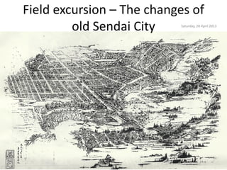
Field excursion – The changes of
         old Sendai City   Saturday, 20 April 2013
Field excursion map (Old Sendai City)


                           GIS : Fatwa Ramdani, Tohoku University, 2013
Modern administrative area


                    GIS : Fatwa Ramdani, Tohoku University, 2013
The main cross road in the ancient
              time
The changes of population
                  (A)         (A')         (B)         (C)
                                                                       A/A'          A/B          A'/B            B/C           A/C
   統計年月日         仙台市の      現・仙台市域         仙台圏の        宮城県の
                                                                       (%)           (%)          (%)             (%)           (%)
                 人口(人)     の人口(人)         人口(人)       人口(人)
1920年(大正9年)    118,984     190,013     320,770     961,768     62.6           37.1         59.2            33.4          12.4
1925年(大正14年)   142,894     221,709     364,002     1,044,036   64.5           39.3         60.9            34.9          13.7
1930年(昭和5年)    190,180     252,017     409,351     1,142,784   75.5           46.5         61.6            35.8          16.6
1935年(昭和10年)   219,547     278,821     450,591     1,234,801   78.7           48.7         61.9            36.5          17.8
1940年(昭和15年)   223,630     284,132     465,094     1,271,238   78.7           48.1         61.1            36.6          17.6
1947年(昭和22年)   293,816     331,570     563,727     1,566,831   88.6           52.1         58.8            36.0          18.8
1950年(昭和25年)   341,685     380,217     623,833     1,663,442   89.9           54.8         60.9            37.5          20.5
1955年(昭和30年)   375,844     414,775     669,422     1,727,065   90.6           56.1         62.0            38.8          21.8
1960年(昭和35年)   425,272     459,876     719,550     1,743,195   92.5           59.1         63.9            41.3          24.4
1965年(昭和40年)   480,925     520,059     784,615     1,753,126   92.5           61.3         66.3            44.8          27.4
1970年(昭和45年)   545,065     598,950     881,306     1,819,223   91.0           61.8         68.0            48.4          30.0
1975年(昭和50年)   615,473     709,326     1,018,375   1,955,267   86.8           60.4         69.7            52.1          31.5
1980年(昭和55年)   664,868     792,036     1,126,742   2,082,320   83.9           59.0         70.3            54.1          31.9
1985年(昭和60年)   700,254     857,335     1,209,050   2,176,295   81.7           57.9         70.9            55.6          32.2
1990年(平成2年)    918,398     918,398     1,292,282   2,248,558   100.0          71.1         71.1            57.5          40.8
1995年(平成7年)    971,297     971,297     1,381,877   2,328,739   100.0          70.3         70.3            59.3          41.7
2000年(平成12年)   1,008,130   1,008,130   1,437,181   2,365,320   100.0          70.1         70.1            60.8          42.6
2005年(平成17年)   1,025,098   1,025,098   1,463,279   2,360,218   100.0          70.1         70.1            62.0          43.4
2010年(平成22年)   1,045,986   1,045,986   1,490,098   2,348,165   100.0          70.2         70.2            63.5          44.5
2012年12月1日
               1,063,024   1,063,024   1,502,358   2,326,957   100.0          70.8         70.8            64.6          45.7
(推計人口)

                                                                                                  http://ja.wikipedia.org/wiki/仙台市
Sendai Subway Tozai Line
(仙台市営地下鉄東西線)


                            http://ja.wikipedia.org/wiki/
Poor transport condition


                       Miyamoto et al, 2010
Sendai after the 1945 air raid


                        http://ja.wikipedia.org/wiki/仙台市
Land use changes
Land use system?
Nagamachi-rifu fault
         •    Reverse fault
         •    Length: ~20 km
         •    Slip rate: 0.5-0.7m/1000 y
         •    Expected M: 7.0

         Source: Ito et al, 2003
Dainenjiyama fault


GIS : Fatwa Ramdani, Tohoku University, 2013
Earthquake history


                                                            GIS : Fatwa Ramdani, Tohoku University, 2013
                                                             Earthquake data: USGS Earthquake Database


In Miyagi a M8.2 earthquake occurred in 1793 nearby seas, and a series of M7.4
and above earthquakes followed this quake until 1978. The average interval
between these quakes was about 37 years
Fluvial system
Water control system
             • Water control system of many
               important river systems
               including Hirose River, the
               improvement and
               development of minor rivers
               to protect from suffered
               serious damage from floods.
             • Water control promote the
               preservation and restoration
               of precious waterside areas
               such as?
仙台 1972
Remote sensing: Fatwa Ramdani, Tohoku
           University, 2013
仙台 2013
Remote sensing: Fatwa Ramdani, Tohoku
           University, 2013
Sendai station 2nd main building early
             Showa era


                                 http://ja.wikipedia.org/wiki/
仙台 Urban
  planning - protect
lives from a tsunami


  Source: Post-Disaster Reconstruction Division of Sendai City
仙台 Urban planning – reconstruction zone


Source: Post-Disaster Reconstruction Division of Sendai City
仙台 2030


仙台 City structure: consolidated urban areas
on transit corridors


                                                        Miyamoto et al, 2010
Lessons learned today?
1.
2.
3.
4.
5.

More Related Content

Similar to Field excursion – the changes of old sendai

京都SWITCH 京都市電DVD鑑賞イベント資料
京都SWITCH 京都市電DVD鑑賞イベント資料京都SWITCH 京都市電DVD鑑賞イベント資料
京都SWITCH 京都市電DVD鑑賞イベント資料京都SWITCH
 
京都SWITCH 京都市電DVD鑑賞イベント資料
京都SWITCH 京都市電DVD鑑賞イベント資料京都SWITCH 京都市電DVD鑑賞イベント資料
京都SWITCH 京都市電DVD鑑賞イベント資料京都SWITCH
 
データで見る函館の公共交通の可能性20200218
データで見る函館の公共交通の可能性20200218データで見る函館の公共交通の可能性20200218
データで見る函館の公共交通の可能性20200218永澤 大樹
 
日本科学未来館 12.17 「科学者に言いたいこと、無いですか?」当日のビデオと併せて御覧下さい→ http://bit.ly/roNEeR
日本科学未来館 12.17 「科学者に言いたいこと、無いですか?」当日のビデオと併せて御覧下さい→ http://bit.ly/roNEeR 日本科学未来館 12.17 「科学者に言いたいこと、無いですか?」当日のビデオと併せて御覧下さい→ http://bit.ly/roNEeR
日本科学未来館 12.17 「科学者に言いたいこと、無いですか?」当日のビデオと併せて御覧下さい→ http://bit.ly/roNEeR Ryu Hayano
 
2908 沼津市のにぎわいづくりへの取り組み
2908 沼津市のにぎわいづくりへの取り組み2908 沼津市のにぎわいづくりへの取り組み
2908 沼津市のにぎわいづくりへの取り組み徹 長谷川
 
20021217 ku-librarians勉強会 #39 : 立命館大学図書館における取り組み : 学生とのかかわりを中心に
20021217 ku-librarians勉強会 #39 : 立命館大学図書館における取り組み : 学生とのかかわりを中心に20021217 ku-librarians勉強会 #39 : 立命館大学図書館における取り組み : 学生とのかかわりを中心に
20021217 ku-librarians勉強会 #39 : 立命館大学図書館における取り組み : 学生とのかかわりを中心にkulibrarians
 

Similar to Field excursion – the changes of old sendai (7)

京都SWITCH 京都市電DVD鑑賞イベント資料
京都SWITCH 京都市電DVD鑑賞イベント資料京都SWITCH 京都市電DVD鑑賞イベント資料
京都SWITCH 京都市電DVD鑑賞イベント資料
 
京都SWITCH 京都市電DVD鑑賞イベント資料
京都SWITCH 京都市電DVD鑑賞イベント資料京都SWITCH 京都市電DVD鑑賞イベント資料
京都SWITCH 京都市電DVD鑑賞イベント資料
 
コース導入講義(田代)
コース導入講義(田代)コース導入講義(田代)
コース導入講義(田代)
 
データで見る函館の公共交通の可能性20200218
データで見る函館の公共交通の可能性20200218データで見る函館の公共交通の可能性20200218
データで見る函館の公共交通の可能性20200218
 
日本科学未来館 12.17 「科学者に言いたいこと、無いですか?」当日のビデオと併せて御覧下さい→ http://bit.ly/roNEeR
日本科学未来館 12.17 「科学者に言いたいこと、無いですか?」当日のビデオと併せて御覧下さい→ http://bit.ly/roNEeR 日本科学未来館 12.17 「科学者に言いたいこと、無いですか?」当日のビデオと併せて御覧下さい→ http://bit.ly/roNEeR
日本科学未来館 12.17 「科学者に言いたいこと、無いですか?」当日のビデオと併せて御覧下さい→ http://bit.ly/roNEeR
 
2908 沼津市のにぎわいづくりへの取り組み
2908 沼津市のにぎわいづくりへの取り組み2908 沼津市のにぎわいづくりへの取り組み
2908 沼津市のにぎわいづくりへの取り組み
 
20021217 ku-librarians勉強会 #39 : 立命館大学図書館における取り組み : 学生とのかかわりを中心に
20021217 ku-librarians勉強会 #39 : 立命館大学図書館における取り組み : 学生とのかかわりを中心に20021217 ku-librarians勉強会 #39 : 立命館大学図書館における取り組み : 学生とのかかわりを中心に
20021217 ku-librarians勉強会 #39 : 立命館大学図書館における取り組み : 学生とのかかわりを中心に
 

More from Fatwa Ramdani

Semi-Automatic Classification Algorithm: The differences between Minimum Dist...
Semi-Automatic Classification Algorithm: The differences between Minimum Dist...Semi-Automatic Classification Algorithm: The differences between Minimum Dist...
Semi-Automatic Classification Algorithm: The differences between Minimum Dist...Fatwa Ramdani
 
PCA and Classification
PCA and ClassificationPCA and Classification
PCA and ClassificationFatwa Ramdani
 
Remote sensing e course (Geohydrology)
Remote sensing e course (Geohydrology)Remote sensing e course (Geohydrology)
Remote sensing e course (Geohydrology)Fatwa Ramdani
 
Pelatihan menulis blog dan website
Pelatihan menulis blog dan websitePelatihan menulis blog dan website
Pelatihan menulis blog dan websiteFatwa Ramdani
 
Could mount fuji erupt
Could mount fuji eruptCould mount fuji erupt
Could mount fuji eruptFatwa Ramdani
 
Disaster management and recovery in northeast japan
Disaster management and recovery in northeast japanDisaster management and recovery in northeast japan
Disaster management and recovery in northeast japanFatwa Ramdani
 

More from Fatwa Ramdani (8)

Semi-Automatic Classification Algorithm: The differences between Minimum Dist...
Semi-Automatic Classification Algorithm: The differences between Minimum Dist...Semi-Automatic Classification Algorithm: The differences between Minimum Dist...
Semi-Automatic Classification Algorithm: The differences between Minimum Dist...
 
PCA and Classification
PCA and ClassificationPCA and Classification
PCA and Classification
 
Remote sensing e course (Geohydrology)
Remote sensing e course (Geohydrology)Remote sensing e course (Geohydrology)
Remote sensing e course (Geohydrology)
 
Management bencana
Management bencanaManagement bencana
Management bencana
 
Yuk menulis
Yuk menulisYuk menulis
Yuk menulis
 
Pelatihan menulis blog dan website
Pelatihan menulis blog dan websitePelatihan menulis blog dan website
Pelatihan menulis blog dan website
 
Could mount fuji erupt
Could mount fuji eruptCould mount fuji erupt
Could mount fuji erupt
 
Disaster management and recovery in northeast japan
Disaster management and recovery in northeast japanDisaster management and recovery in northeast japan
Disaster management and recovery in northeast japan
 

Field excursion – the changes of old sendai

  • 1. Field excursion – The changes of old Sendai City Saturday, 20 April 2013
  • 2. Field excursion map (Old Sendai City) GIS : Fatwa Ramdani, Tohoku University, 2013
  • 3. Modern administrative area GIS : Fatwa Ramdani, Tohoku University, 2013
  • 4. The main cross road in the ancient time
  • 5. The changes of population (A) (A') (B) (C) A/A' A/B A'/B B/C A/C 統計年月日 仙台市の 現・仙台市域 仙台圏の 宮城県の (%) (%) (%) (%) (%) 人口(人) の人口(人) 人口(人) 人口(人) 1920年(大正9年) 118,984 190,013 320,770 961,768 62.6 37.1 59.2 33.4 12.4 1925年(大正14年) 142,894 221,709 364,002 1,044,036 64.5 39.3 60.9 34.9 13.7 1930年(昭和5年) 190,180 252,017 409,351 1,142,784 75.5 46.5 61.6 35.8 16.6 1935年(昭和10年) 219,547 278,821 450,591 1,234,801 78.7 48.7 61.9 36.5 17.8 1940年(昭和15年) 223,630 284,132 465,094 1,271,238 78.7 48.1 61.1 36.6 17.6 1947年(昭和22年) 293,816 331,570 563,727 1,566,831 88.6 52.1 58.8 36.0 18.8 1950年(昭和25年) 341,685 380,217 623,833 1,663,442 89.9 54.8 60.9 37.5 20.5 1955年(昭和30年) 375,844 414,775 669,422 1,727,065 90.6 56.1 62.0 38.8 21.8 1960年(昭和35年) 425,272 459,876 719,550 1,743,195 92.5 59.1 63.9 41.3 24.4 1965年(昭和40年) 480,925 520,059 784,615 1,753,126 92.5 61.3 66.3 44.8 27.4 1970年(昭和45年) 545,065 598,950 881,306 1,819,223 91.0 61.8 68.0 48.4 30.0 1975年(昭和50年) 615,473 709,326 1,018,375 1,955,267 86.8 60.4 69.7 52.1 31.5 1980年(昭和55年) 664,868 792,036 1,126,742 2,082,320 83.9 59.0 70.3 54.1 31.9 1985年(昭和60年) 700,254 857,335 1,209,050 2,176,295 81.7 57.9 70.9 55.6 32.2 1990年(平成2年) 918,398 918,398 1,292,282 2,248,558 100.0 71.1 71.1 57.5 40.8 1995年(平成7年) 971,297 971,297 1,381,877 2,328,739 100.0 70.3 70.3 59.3 41.7 2000年(平成12年) 1,008,130 1,008,130 1,437,181 2,365,320 100.0 70.1 70.1 60.8 42.6 2005年(平成17年) 1,025,098 1,025,098 1,463,279 2,360,218 100.0 70.1 70.1 62.0 43.4 2010年(平成22年) 1,045,986 1,045,986 1,490,098 2,348,165 100.0 70.2 70.2 63.5 44.5 2012年12月1日 1,063,024 1,063,024 1,502,358 2,326,957 100.0 70.8 70.8 64.6 45.7 (推計人口) http://ja.wikipedia.org/wiki/仙台市
  • 6. Sendai Subway Tozai Line (仙台市営地下鉄東西線) http://ja.wikipedia.org/wiki/
  • 7. Poor transport condition Miyamoto et al, 2010
  • 8. Sendai after the 1945 air raid http://ja.wikipedia.org/wiki/仙台市
  • 11. Nagamachi-rifu fault • Reverse fault • Length: ~20 km • Slip rate: 0.5-0.7m/1000 y • Expected M: 7.0 Source: Ito et al, 2003
  • 12. Dainenjiyama fault GIS : Fatwa Ramdani, Tohoku University, 2013
  • 13. Earthquake history GIS : Fatwa Ramdani, Tohoku University, 2013 Earthquake data: USGS Earthquake Database In Miyagi a M8.2 earthquake occurred in 1793 nearby seas, and a series of M7.4 and above earthquakes followed this quake until 1978. The average interval between these quakes was about 37 years
  • 15. Water control system • Water control system of many important river systems including Hirose River, the improvement and development of minor rivers to protect from suffered serious damage from floods. • Water control promote the preservation and restoration of precious waterside areas such as?
  • 16. 仙台 1972 Remote sensing: Fatwa Ramdani, Tohoku University, 2013
  • 17. 仙台 2013 Remote sensing: Fatwa Ramdani, Tohoku University, 2013
  • 18. Sendai station 2nd main building early Showa era http://ja.wikipedia.org/wiki/
  • 19. 仙台 Urban planning - protect lives from a tsunami Source: Post-Disaster Reconstruction Division of Sendai City
  • 20. 仙台 Urban planning – reconstruction zone Source: Post-Disaster Reconstruction Division of Sendai City
  • 21. 仙台 2030 仙台 City structure: consolidated urban areas on transit corridors Miyamoto et al, 2010