The Floods Of 2013 Remembering Some Of This Year's Lessons From Natural Disasters
•Transferir como PPTX, PDF•
0 gostou•576 visualizações

This document discusses flooding and lessons learned from past flood events. It covers the physical effects of floods including inundation, erosion, and economic losses. It also discusses causes of flood risk such as development in floodplains and interaction with hazardous materials. Case studies from flooding in Lebanon and Colorado are provided to illustrate impacts such as damage, evacuations, and deaths. The document advocates for integrating scientific and policy approaches to improve preparedness, protection, warnings, response and recovery from flooding through educational programs and risk assessment.

Recomendados
Mais conteúdo relacionado
Mais procurados
Mais procurados (20)
Destaque
Destaque (20)
Semelhante a The Floods Of 2013 Remembering Some Of This Year's Lessons From Natural Disasters
Semelhante a The Floods Of 2013 Remembering Some Of This Year's Lessons From Natural Disasters (20)
Mais de Professor Eric K. Noji, M.D., MPH, DTMH(Lon), FRCP(UK)hon
Mais de Professor Eric K. Noji, M.D., MPH, DTMH(Lon), FRCP(UK)hon (20)
Último
Último (20)
The Floods Of 2013 Remembering Some Of This Year's Lessons From Natural Disasters
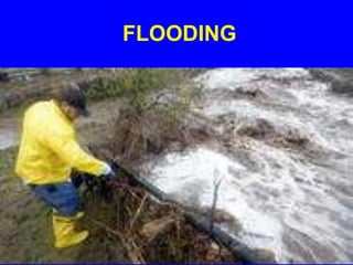
- 1. FLOODING
- 2. REMEMBERING SOME OF THE LESSONS FROM 2013’S DISASTERS PART 3: FLOODS
- 3. PHYSICAL EFFECTS OF FLOODS- A PART OF THE NATURAL WATER CYCLE INUNDATION, HIGH-VELOCITY FLOW OF WATER, HIGH-VOLUME DISCHARGE, EROSION, AND SCOUR
- 4. A RISK ASSESSMENT LETS DECISIONMAKERS KNOW WHAT WILL LIKELY HAPPEN IN A FLOOD DAMAGE FROM INUNDATION EROSION, SCOUR, AND LANDSLIDES RISK LOSS OF FUNCTION ECONOMIC LOSS
- 5. RISKS ASSOCIATED WITH FLOODS DAMAGE TO CONTENTS, LOSS OF FUNCTION OF BUILDINGS AND INFRASTRUCTURE, RELEASE OF HAZARDOUS MATERIALS, TRANSPORTATION OF DEBRIS, AUTOS, AND HOUSES, ENVIRONMENTAL DEAD ZONES, AND DISEASE
- 6. CAUSES OF RISK LOSS OF FUNCTION OF STRUCTURES IN FLOODPLAIN INUNDATION INTERACTION WITH HAZARDOUS MATERIALS FLOODS STRUCTURE & CONTENTS: DAMAGE FROM WATER DISASTER LABORATORIES WATER BORNE DISEASES (HEALTH PROBLEMS) EROSION AND MUDFLOWS CONTAMINATION OF GROUND WATER
- 7. An element’s vulnerability (fragility) is the result of either a community’s actions and/or nature’s actions that change some part of the regional water cycle (e.g., precipitation, storage, runoff, transpiration, evaporation).
- 8. LESSONS FROM THE COMMUNITY Vulnerabilities typically enter during the planning, design, and construction phases of a community’s building and critical infrastructure programs.
- 9. LESSONS FROM A COMMUNITY • Urban development or industrial development in areas that were formerly wetlands and locating buildings and infrastructure in a river floodplain will increase the risk (i.e., chance of loss).
- 10. LESSONS FROM NATURE • A flash flood, Ice jams/ice dams on the river, and rapid melt of snow and ice and the resultant runoff will usually lead to a flood disaster.
- 11. LESSONS FROM NATURE • Extreme or prolonged precipitation caused by a stalled low-pressure system, or after a long, hot, dry season, or after a wildfire will usually exacerbate flooding risks.
- 12. A COMMUNITY’S ACTIONS • Actions that increase or decrease river gradients (deforestation, dams, etc.,) and actions that change the runoff pattern or rate (e.g., the city’s concrete footprint) will exacerbate flood risks.
- 13. EXAMPLE SEVERE FLOODING IN LEBANON JANUARY 4, 2013
- 14. THE THAWING OF A WINTER STORM CAUSED FLOODING THAT CLOSED SCHOOLS THROUGHOUT THE COUNTRY AND LEFT FOUR DEAD
- 17. EXAMPLE HISTORIC MOUNTAIN FLOODING IN COLORADO AFTER A HOT, DRY SUMMER MARKED BY DROUGHT AND WILDFIRES SEPTEMBER, 15, 2013
- 18. RECORDS SET IN 1919 WERE BROKEN AFTER A WEEK-LONG RAINFALL
- 19. BOULDER, CO WAS HIT ESPECIALLY HARD
- 20. BOULDER
- 21. Boulder, with a population of about 100,000, is located 25 miles (40 km) northwest of Denver and sited at the base of the foothills of the Rocky Mountains at an elevation of 5,430 feet (1,655 m).
- 22. IMMEDIATE IMPACTS • • • • • • • WIDESPREAD POWER OUTAGES UNIVERSITY OF COLORADO CLOSED SCHOOLS CLOSED MUDSLIDES INUNDATION ISOLATED MTN. COMMUNITIES FOOD AND WATER DEPLETED
- 23. Miles from the Rocky Mountains, debris-filled rivers became muddy seas that overflowed banks and inundated farms and towns.
- 25. CUMMULATIVE IMPACTS • • • • • • • $ 150 MILLION IN DAMAGE THOUSANDS EVACUATED COMMUNITIES ISOLATED NATIONAL GUARD ACTIVATED FEDERAL ASSISTANCE APPROVED 1,200 STRANDED AT LEAST 5 DEAD
- 27. FLOODING
- 28. FLOODING
- 29. CONTINUING RAINFALL, DAMAGED ROADS, AND LANDSLIDES SLOWED SEARCH AND RESCUE OPERATIONS
- 30. ROADS DESTROYED
- 32. AIRLIFTING
- 34. FLOOD RISK • FLOOD HAZARDS •INVENTORY •VULNERABILITY •LOCATION ACCEPTABLE RISK RISK UNACCEPTABLE RISK FLOOD DISASTER RESILIENCE DATA BASES AND INFORMATION COMMUNITIES POLICY OPTIONS HAZARDS: GROUND SHAKING GROUND FAILURE SURFACE FAULTING TECTONIC DEFORMATION TSUNAMI RUN UP AFTERSHOCKS •PREPAREDNESS •PROTECTION •FORECASTS/WARNINGS •EMERGENCY RESPONSE •RECOVERY and RECONSTRUCTION
- 35. CREATING TURNING POINTS FOR FLOOD DISASTER RESILIENCE USING EDUCATIONAL SURGES CONTAINING THE PAST AND PRESENT LESSONS TO FOSTER AND ACCELERATE THE CREATION OF TURNING POINTS
- 36. 2014--2020 IS A GOOD TIME FOR A GLOBAL SURGE IN EDUCATIONAL, TECHNICAL, HEALTH CARE, AND POLITICAL CAPACITY BUILDING IN ALL FIVE PILLARS OF COMMUNITY DISASTER RESILIENCE
- 37. CREATING TURNING POINTS FOR FLOOD DISASTER RESILIENCE INTEGRATION OF SCIENTIFIC AND TECHNICAL SOLUTIONS WITH POLITICAL SOLUTIONS FOR POLICIES ON PREPAREDNESS, PROTECTION, EARLY WARNING, EMERGENCY RESPONSE, AND RECOVERY
- 38. INTEGRATION OF TECHNICAL AND POLITICAL CONSIDERATIONS OPPORTUNITIES FOR TURNING POINTS: For Disaster Resilience on local, regional, national, and global scales THE KNOWLEDGE BASE Real and Near- Real Time Monitoring Hazard, Vulnerability and Risk Characterization Best Practices for Mitigation Adaptation and Monitoring Situation Data Bases APPLICATIONS EDUCATIONAL SURGES Relocation/Rerouting of Cities and City Lifelines Enlighten Communities on Their Risks Create a Hazard Zonation Map as a Policy Tool Implement Modern Codes and Lifeline Standards Cause & Effect Relationships Introduce New Technologies Anticipatory Actions for all Events and Situations Move Towards A Disaster Intelligent Community Interfaces with all Real- and Near Real-Time Sources Gateways to a Deeper Understanding Build Strategic Equity Through Disaster Scenarios Involve Partners in Turning Point Experimemts Multiply Capability by International Twinning Update Knowledge Bases After Each Disaster