
Recomendados
Mais conteúdo relacionado
Mais procurados
Mais procurados (20)
Destaque
Semelhante a Colorado's Great Sand Dunes
Semelhante a Colorado's Great Sand Dunes (20)
Último
Último (17)
Colorado's Great Sand Dunes
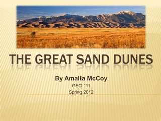
- 1. THE GREAT SAND DUNES By Amalia McCoy GEO 111 Spring 2012
- 2. The Great Sand dunes of Colorado are the tallest in North America. Rising about 750 feet Covering roughly 30 square miles
- 3. EARTH’S NATURAL PROCESS Formed by sand and soil deposits of the Rio Grande and other streams and smaller rivers which flow into the Rio Grande Western winds picked up the sand and soil deposits from the River’s flood plain The wind loses power right before crossing the Sangre de Cristo Range The sand was deposited on the eastern edge of the valley The wind changes the formation and shapes of the dunes daily
- 4. AEOLIAN DEPOSITION Definition: Sand and dust moved by the wind are eventually deposited when the wind dies down. Image taken from: http://web.ncf.ca/jim/sand/overview/grainflowAnimation.gif
- 5. SLIP FACE The steeper leeward face of a sand dune •Wind erodes the windward side of the dune which force the grains of sand up and over the crest to be deposited on the other side •Maintains an angle of 32 degrees- 34 degrees. Image taken from: http://www.geocaching.com/seek/cache_details.aspx?guid=c93e835c-617b- 4c33-bc61-1e2b484e267a
- 6. STAR DUNES BARCHAN DUNES • Formed by multidirectional winds • form in places where there is limited sand and a constant wind •Have 3 or 4 arms direction •Large pyramid shape dunes •crescent-shaped dunes that concave downwind •Face the prevailing wind Image taken from: http://www.nps.gov/grsa/naturescience/images/star_dune_form Image taken from: http://www.indiana.edu/~geol116/Week11/dunes2.jpg ation.jpg
- 7. TRANSVERSE DUNES SEIF DUNES •become aligned together along a plane •Linear or longitudinal dune perpendicular to the wind •Represents an intermediate direction •Occur where the supply of sand is greater between 2 dominate wind directions, blowing than that of where barchans are formed from one direction part of the year and another direction the rest of the year •Face the prevailing wind •Usually parallel Image taken from: http://icons- ak.wunderground.com/data/wximagenew/e/Eaglz/196.jpg Image taken from: http://giltphoto.com/images/Colorado/Great%20Sand%20Dune s%20National%20Park/GreatSandDunes35w.jpg Image taken from: Image taken from: http://digital-desert.com/natural-formations/SDGfig4.gif http://web.arc.losrios.edu/~borougt/DesertDiagrams.htm
- 8. FLUVIAL PROCESS •The Medano Creek that flows next to the Sand dunes, is an Intermittent Stream •Intermittent stream- is known as a seasonal stream where water flows for ONLY part of the year. •When the water level is low the stream has braided channels •Braided channels- consisting of multiple interwoven and interconnected channels that are separated by low bars or islands of sand, gravel and other lose debris. •During the winter and wet seasons the stream fills up •The stream carries and deposits sand •Deposition- whatever is picked up must be set down
- 9. DEFLATION AND ABRASION Deflation- the overall shifting of lose debris either through air or along the ground Abrasion- wind forces the particles of sand against the mountains with such force that a sand blasting effect takes place and erodes the surface of other rocks and the Sangre de Cristo Mountains. The landscape is constantly changing
- 10. BIBLIOGRAPHY http://en.wikipedia.org/wiki/Great_Sand_Dunes_National_Park_and_Preserve http://www.indiana.edu/~geol116/Week11/wk11.htm http://mycolorado.org/sand_dunes.html http://www.americansouthwest.net/colorado/great_sand_dunes/national_monument.html http://web.ncf.ca/jim/sand/overview/grainflowAnimation.gif http://www.geocaching.com/seek/cache_details.aspx?guid=c93e835c-617b-4c33-bc61- 1e2b484e267a http://www.nps.gov/grsa/naturescience/images/star_dune_formation.jpg http://www.indiana.edu/~geol116/Week11/dunes2.jpg http://giltphoto.com/images/Colorado/Great%20Sand%20Dunes%20National%20Park/Gre atSandDunes35w.jpg http://web.arc.losrios.edu/~borougt/DesertDiagrams.htm http://icons-ak.wunderground.com/data/wximagenew/e/Eaglz/196.jpg http://digital-desert.com/natural-formations/SDGfig4.gif