Scale - Geography Skill
•
2 likes•3,048 views

Scale is used from mapwork in Geography - NSW Curriculum

Recommended
More Related Content
What's hot
What's hot (20)
Similar to Scale - Geography Skill
Similar to Scale - Geography Skill (20)
More from Mr Shipp
More from Mr Shipp (20)
Recently uploaded
Recently uploaded (20)
Scale - Geography Skill
- 1. Scale Mr ShippGeography Skills and Tools
- 2. • To draw a map of any part of the world, the area must be reduced in size, or scaled down, so that it can fit on to a sheet of paper. • Therefore the scale on a map shows us how the distance on a map relates to the actual distance on the earths surface. • Scales allow you to work out distances between places as well as the size of large towns, lakes, forests and the map area. Border Orientation Legend Title Scale Source
- 3. • These were models because they represent the real thing – only on a smaller scale. • Similarly, a map is a drawing of an area that is at a smaller scale than in reality. • To draw a map of any part of the world, the area must be reduced in size, or scaled down, so that it can fit onto a sheet of paper.
- 4. • Map Scales can be expressed in 3 ways: 1. As a statement; for example: - 1 centimetre (on a map) represents 100 000 centimetres (in real life) or - 1 centimetre represents 1 Kilometre. 2. As a ratio or representative fraction; for example: - 1: 100 000 or 1 ______ 100 000 3. As a linear scale; for example: 0km 1 2 3 4 5 6 7 8 9 10 11 12
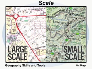
- 7. Small and Large Scales large-scale maps show a small area with a great amount of detail small-scale maps show a large area with a small amount of detail