SlideShare a Scribd company logo
1 of 13
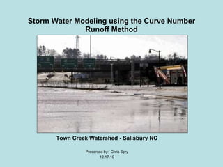
Storm Water Modeling using the Curve Number Runoff Method Town Creek Watershed - Salisbury NC Presented by:  Chris Spry 12.17.10
Context of Problem ,[object Object],[object Object],[object Object],[object Object]
 
Project Objectives ,[object Object],[object Object],[object Object],[object Object]
Methods (Data Collection) ,[object Object],[object Object],[object Object],[object Object],The following  data was required  to complete the project:
 
1978 Aerial vs. 2009 Satellite Imagery Zoomed
Methods (Incorporate data into GIS) ,[object Object],[object Object],[object Object],[object Object],[object Object],[object Object]
Methods: (CRN) Equation ,[object Object],[object Object],[object Object],[object Object],[object Object],[object Object],[object Object],[object Object],[object Object],[object Object],[object Object],[object Object],[object Object]
Results Land Use Statistics for the year (1978) Forest =  53% Open Space =  40% Urban = 7% Flow Accumulation  at Innes St. point from a 4 inch rainfall: 78,592 Land Use Statistics for the year (2009) Forest = 50 % Open Space = 35% Urban = 15% Flow Accumulation  at Innes St. point from a 4 inch rainfall:  92,131 Land Use Change between 1978 and 2009 Forest = -3%  Open Space = - 5% Urban = +8%
Project Significance and Encountered Issues ,[object Object],[object Object],[object Object],[object Object]
 
Thanks for your attention! Questions?

More Related Content

What's hot

TGS Arcis- 2014 Marketing Survey Threehills 3D
TGS Arcis- 2014 Marketing Survey Threehills 3DTGS Arcis- 2014 Marketing Survey Threehills 3D
TGS Arcis- 2014 Marketing Survey Threehills 3DTGS
 
The performance of portable mid-infrared spectroscopy for the prediction of s...
The performance of portable mid-infrared spectroscopy for the prediction of s...The performance of portable mid-infrared spectroscopy for the prediction of s...
The performance of portable mid-infrared spectroscopy for the prediction of s...ExternalEvents
 
AP Calculus AB March 12, 2009
AP Calculus AB March 12, 2009AP Calculus AB March 12, 2009
AP Calculus AB March 12, 2009Darren Kuropatwa
 
Land use classification using taxi gps traces
Land use classification using taxi gps tracesLand use classification using taxi gps traces
Land use classification using taxi gps tracesecwayerode
 
S-Plus: The Data Reduction Process
S-Plus: The Data Reduction ProcessS-Plus: The Data Reduction Process
S-Plus: The Data Reduction ProcessEduardo S. Pereira
 
Bouvet_IGARSS2011.ppt
Bouvet_IGARSS2011.pptBouvet_IGARSS2011.ppt
Bouvet_IGARSS2011.pptgrssieee
 
OESF Logging Road Sedimentation GIS
OESF Logging Road Sedimentation GISOESF Logging Road Sedimentation GIS
OESF Logging Road Sedimentation GISfireflytza
 
Surface Water modelling using Remote Sensing
Surface Water modelling using Remote SensingSurface Water modelling using Remote Sensing
Surface Water modelling using Remote SensingArk Arjun
 
Land use classification using taxi gps traces
Land use classification using taxi gps tracesLand use classification using taxi gps traces
Land use classification using taxi gps tracesEcwaytech
 
GENERATING FINE RESOLUTION LEAF AREA INDEX MAPS FOR BOREAL FORESTS OF FINLAND...
GENERATING FINE RESOLUTION LEAF AREA INDEX MAPS FOR BOREAL FORESTS OF FINLAND...GENERATING FINE RESOLUTION LEAF AREA INDEX MAPS FOR BOREAL FORESTS OF FINLAND...
GENERATING FINE RESOLUTION LEAF AREA INDEX MAPS FOR BOREAL FORESTS OF FINLAND...grssieee
 
A city to national-scale inverse modeling system to assess the potential of s...
A city to national-scale inverse modeling system to assess the potential of s...A city to national-scale inverse modeling system to assess the potential of s...
A city to national-scale inverse modeling system to assess the potential of s...Integrated Carbon Observation System (ICOS)
 
frison.ppt
frison.pptfrison.ppt
frison.pptgrssieee
 
EcoTas13 BradEvans e-MAST
EcoTas13 BradEvans e-MASTEcoTas13 BradEvans e-MAST
EcoTas13 BradEvans e-MASTTERN Australia
 
SURF_Poster_REU2016Team3
SURF_Poster_REU2016Team3SURF_Poster_REU2016Team3
SURF_Poster_REU2016Team3Pablo Valle
 
Nigtrogen Pollution Change Due to Land Use Changes in the Plano/Allen area.
Nigtrogen Pollution Change Due to Land Use Changes in the Plano/Allen area.Nigtrogen Pollution Change Due to Land Use Changes in the Plano/Allen area.
Nigtrogen Pollution Change Due to Land Use Changes in the Plano/Allen area.stoughne
 

What's hot (19)

TGS Arcis- 2014 Marketing Survey Threehills 3D
TGS Arcis- 2014 Marketing Survey Threehills 3DTGS Arcis- 2014 Marketing Survey Threehills 3D
TGS Arcis- 2014 Marketing Survey Threehills 3D
 
The performance of portable mid-infrared spectroscopy for the prediction of s...
The performance of portable mid-infrared spectroscopy for the prediction of s...The performance of portable mid-infrared spectroscopy for the prediction of s...
The performance of portable mid-infrared spectroscopy for the prediction of s...
 
AP Calculus AB March 12, 2009
AP Calculus AB March 12, 2009AP Calculus AB March 12, 2009
AP Calculus AB March 12, 2009
 
Land use classification using taxi gps traces
Land use classification using taxi gps tracesLand use classification using taxi gps traces
Land use classification using taxi gps traces
 
S-Plus: The Data Reduction Process
S-Plus: The Data Reduction ProcessS-Plus: The Data Reduction Process
S-Plus: The Data Reduction Process
 
Iwmo18 ueslei
Iwmo18 uesleiIwmo18 ueslei
Iwmo18 ueslei
 
Bouvet_IGARSS2011.ppt
Bouvet_IGARSS2011.pptBouvet_IGARSS2011.ppt
Bouvet_IGARSS2011.ppt
 
OESF Logging Road Sedimentation GIS
OESF Logging Road Sedimentation GISOESF Logging Road Sedimentation GIS
OESF Logging Road Sedimentation GIS
 
Surface Water modelling using Remote Sensing
Surface Water modelling using Remote SensingSurface Water modelling using Remote Sensing
Surface Water modelling using Remote Sensing
 
Land use classification using taxi gps traces
Land use classification using taxi gps tracesLand use classification using taxi gps traces
Land use classification using taxi gps traces
 
NGS Report
NGS ReportNGS Report
NGS Report
 
GENERATING FINE RESOLUTION LEAF AREA INDEX MAPS FOR BOREAL FORESTS OF FINLAND...
GENERATING FINE RESOLUTION LEAF AREA INDEX MAPS FOR BOREAL FORESTS OF FINLAND...GENERATING FINE RESOLUTION LEAF AREA INDEX MAPS FOR BOREAL FORESTS OF FINLAND...
GENERATING FINE RESOLUTION LEAF AREA INDEX MAPS FOR BOREAL FORESTS OF FINLAND...
 
A city to national-scale inverse modeling system to assess the potential of s...
A city to national-scale inverse modeling system to assess the potential of s...A city to national-scale inverse modeling system to assess the potential of s...
A city to national-scale inverse modeling system to assess the potential of s...
 
frison.ppt
frison.pptfrison.ppt
frison.ppt
 
EcoTas13 BradEvans e-MAST
EcoTas13 BradEvans e-MASTEcoTas13 BradEvans e-MAST
EcoTas13 BradEvans e-MAST
 
SURF_poster
SURF_posterSURF_poster
SURF_poster
 
SURF_Poster_REU2016Team3
SURF_Poster_REU2016Team3SURF_Poster_REU2016Team3
SURF_Poster_REU2016Team3
 
Nigtrogen Pollution Change Due to Land Use Changes in the Plano/Allen area.
Nigtrogen Pollution Change Due to Land Use Changes in the Plano/Allen area.Nigtrogen Pollution Change Due to Land Use Changes in the Plano/Allen area.
Nigtrogen Pollution Change Due to Land Use Changes in the Plano/Allen area.
 
Presentation
PresentationPresentation
Presentation
 

Viewers also liked

Group Final Project (Revised)
Group Final Project (Revised)Group Final Project (Revised)
Group Final Project (Revised)Wuzzy13
 
Chris Spry Final Rs Project
Chris Spry Final Rs ProjectChris Spry Final Rs Project
Chris Spry Final Rs ProjectWuzzy13
 
Group Final project
Group Final projectGroup Final project
Group Final projectWuzzy13
 
Chris Spry Ozone Project
Chris Spry Ozone ProjectChris Spry Ozone Project
Chris Spry Ozone ProjectWuzzy13
 
Apache Web Services
Apache Web ServicesApache Web Services
Apache Web Serviceslkurriger
 
Final project2
Final project2Final project2
Final project2Wuzzy13
 

Viewers also liked (9)

Group Final Project (Revised)
Group Final Project (Revised)Group Final Project (Revised)
Group Final Project (Revised)
 
Growing Your Own Herbs
Growing Your Own HerbsGrowing Your Own Herbs
Growing Your Own Herbs
 
Chris Spry Final Rs Project
Chris Spry Final Rs ProjectChris Spry Final Rs Project
Chris Spry Final Rs Project
 
Group Final project
Group Final projectGroup Final project
Group Final project
 
Chris Spry Ozone Project
Chris Spry Ozone ProjectChris Spry Ozone Project
Chris Spry Ozone Project
 
Apache Web Services
Apache Web ServicesApache Web Services
Apache Web Services
 
Final project2
Final project2Final project2
Final project2
 
Choosing A Garden That Is Perfect For You
Choosing A Garden That Is Perfect For YouChoosing A Garden That Is Perfect For You
Choosing A Garden That Is Perfect For You
 
Preparing Healthy Soil For Your Garden
Preparing Healthy Soil For Your GardenPreparing Healthy Soil For Your Garden
Preparing Healthy Soil For Your Garden
 

Similar to Chris Spry

Use of Satellite Data for Feasibility Study And Preliminary Design Project Re...
Use of Satellite Data for Feasibility Study And Preliminary Design Project Re...Use of Satellite Data for Feasibility Study And Preliminary Design Project Re...
Use of Satellite Data for Feasibility Study And Preliminary Design Project Re...IJERDJOURNAL
 
Flooding areas of Ofanto river using advanced topographic and hydraulic appro...
Flooding areas of Ofanto river using advanced topographic and hydraulic appro...Flooding areas of Ofanto river using advanced topographic and hydraulic appro...
Flooding areas of Ofanto river using advanced topographic and hydraulic appro...Lia Romano
 
Modeling the Effects of Land Use Change on Flooding
Modeling the Effects of Land Use Change on FloodingModeling the Effects of Land Use Change on Flooding
Modeling the Effects of Land Use Change on FloodingAdam Nayak
 
IRJET- Estimation of Surface Runoff using Curve Number Method- A Geospatial A...
IRJET- Estimation of Surface Runoff using Curve Number Method- A Geospatial A...IRJET- Estimation of Surface Runoff using Curve Number Method- A Geospatial A...
IRJET- Estimation of Surface Runoff using Curve Number Method- A Geospatial A...IRJET Journal
 
Watershed Anylsis for Sevenmile Creek
Watershed Anylsis for Sevenmile CreekWatershed Anylsis for Sevenmile Creek
Watershed Anylsis for Sevenmile CreekAaron King
 
Streamflow simulation using radar-based precipitation applied to the Illinois...
Streamflow simulation using radar-based precipitation applied to the Illinois...Streamflow simulation using radar-based precipitation applied to the Illinois...
Streamflow simulation using radar-based precipitation applied to the Illinois...Alireza Safari
 
Hydrological Risk Assessment at Praia, Cape Verde
Hydrological Risk Assessment at Praia, Cape VerdeHydrological Risk Assessment at Praia, Cape Verde
Hydrological Risk Assessment at Praia, Cape VerdeIJEAB
 
Birr - Identifying Critical Portions of the Landscape
Birr - Identifying Critical Portions of the LandscapeBirr - Identifying Critical Portions of the Landscape
Birr - Identifying Critical Portions of the LandscapeJose A. Hernandez
 
Rainfall Runoff Modelling on the Lower Tapi Basin using HEC-HMS
Rainfall Runoff Modelling on the Lower Tapi Basin using HEC-HMSRainfall Runoff Modelling on the Lower Tapi Basin using HEC-HMS
Rainfall Runoff Modelling on the Lower Tapi Basin using HEC-HMSAnkit Balyan MBA, B.Tech.
 
A GIS-Based Framework to Identify Opportunities to Use Surface Water to Offse...
A GIS-Based Framework to Identify Opportunities to Use Surface Water to Offse...A GIS-Based Framework to Identify Opportunities to Use Surface Water to Offse...
A GIS-Based Framework to Identify Opportunities to Use Surface Water to Offse...ASADULISLAMSORIF
 
IRJET- Estimation of Hydrological and Hydraulics Parameters for Bridge De...
IRJET-  	  Estimation of Hydrological and Hydraulics Parameters for Bridge De...IRJET-  	  Estimation of Hydrological and Hydraulics Parameters for Bridge De...
IRJET- Estimation of Hydrological and Hydraulics Parameters for Bridge De...IRJET Journal
 
Morphometric Analysis to Identify Erosion Prone Areas on the Upper Blue Nile ...
Morphometric Analysis to Identify Erosion Prone Areas on the Upper Blue Nile ...Morphometric Analysis to Identify Erosion Prone Areas on the Upper Blue Nile ...
Morphometric Analysis to Identify Erosion Prone Areas on the Upper Blue Nile ...IRJET Journal
 

Similar to Chris Spry (20)

Use of Satellite Data for Feasibility Study And Preliminary Design Project Re...
Use of Satellite Data for Feasibility Study And Preliminary Design Project Re...Use of Satellite Data for Feasibility Study And Preliminary Design Project Re...
Use of Satellite Data for Feasibility Study And Preliminary Design Project Re...
 
Flooding areas of Ofanto river using advanced topographic and hydraulic appro...
Flooding areas of Ofanto river using advanced topographic and hydraulic appro...Flooding areas of Ofanto river using advanced topographic and hydraulic appro...
Flooding areas of Ofanto river using advanced topographic and hydraulic appro...
 
Modeling the Effects of Land Use Change on Flooding
Modeling the Effects of Land Use Change on FloodingModeling the Effects of Land Use Change on Flooding
Modeling the Effects of Land Use Change on Flooding
 
IRJET- Estimation of Surface Runoff using Curve Number Method- A Geospatial A...
IRJET- Estimation of Surface Runoff using Curve Number Method- A Geospatial A...IRJET- Estimation of Surface Runoff using Curve Number Method- A Geospatial A...
IRJET- Estimation of Surface Runoff using Curve Number Method- A Geospatial A...
 
Hampton-Rds-MATS-Poster-2
Hampton-Rds-MATS-Poster-2Hampton-Rds-MATS-Poster-2
Hampton-Rds-MATS-Poster-2
 
Watershed Anylsis for Sevenmile Creek
Watershed Anylsis for Sevenmile CreekWatershed Anylsis for Sevenmile Creek
Watershed Anylsis for Sevenmile Creek
 
Streamflow simulation using radar-based precipitation applied to the Illinois...
Streamflow simulation using radar-based precipitation applied to the Illinois...Streamflow simulation using radar-based precipitation applied to the Illinois...
Streamflow simulation using radar-based precipitation applied to the Illinois...
 
Ijirt148701 paper
Ijirt148701 paperIjirt148701 paper
Ijirt148701 paper
 
Hydrological Risk Assessment at Praia, Cape Verde
Hydrological Risk Assessment at Praia, Cape VerdeHydrological Risk Assessment at Praia, Cape Verde
Hydrological Risk Assessment at Praia, Cape Verde
 
Birr - Identifying Critical Portions of the Landscape
Birr - Identifying Critical Portions of the LandscapeBirr - Identifying Critical Portions of the Landscape
Birr - Identifying Critical Portions of the Landscape
 
Ijciet 08 04_235
Ijciet 08 04_235Ijciet 08 04_235
Ijciet 08 04_235
 
Rainfall Runoff Modelling on the Lower Tapi Basin using HEC-HMS
Rainfall Runoff Modelling on the Lower Tapi Basin using HEC-HMSRainfall Runoff Modelling on the Lower Tapi Basin using HEC-HMS
Rainfall Runoff Modelling on the Lower Tapi Basin using HEC-HMS
 
06Surface_Runoff.pdf
06Surface_Runoff.pdf06Surface_Runoff.pdf
06Surface_Runoff.pdf
 
A GIS-Based Framework to Identify Opportunities to Use Surface Water to Offse...
A GIS-Based Framework to Identify Opportunities to Use Surface Water to Offse...A GIS-Based Framework to Identify Opportunities to Use Surface Water to Offse...
A GIS-Based Framework to Identify Opportunities to Use Surface Water to Offse...
 
IRJET- Estimation of Hydrological and Hydraulics Parameters for Bridge De...
IRJET-  	  Estimation of Hydrological and Hydraulics Parameters for Bridge De...IRJET-  	  Estimation of Hydrological and Hydraulics Parameters for Bridge De...
IRJET- Estimation of Hydrological and Hydraulics Parameters for Bridge De...
 
FLOODPLAIN HAZARD MAPPING AND ASSESSMENT OF RIVER KABUL USING HEC-RAS 2D MODEL
FLOODPLAIN HAZARD MAPPING AND ASSESSMENT OF RIVER KABUL USING HEC-RAS 2D MODELFLOODPLAIN HAZARD MAPPING AND ASSESSMENT OF RIVER KABUL USING HEC-RAS 2D MODEL
FLOODPLAIN HAZARD MAPPING AND ASSESSMENT OF RIVER KABUL USING HEC-RAS 2D MODEL
 
Goiul.ppt
Goiul.pptGoiul.ppt
Goiul.ppt
 
Work_Sample_Paper
Work_Sample_PaperWork_Sample_Paper
Work_Sample_Paper
 
2 ijsrms-02753
2 ijsrms-027532 ijsrms-02753
2 ijsrms-02753
 
Morphometric Analysis to Identify Erosion Prone Areas on the Upper Blue Nile ...
Morphometric Analysis to Identify Erosion Prone Areas on the Upper Blue Nile ...Morphometric Analysis to Identify Erosion Prone Areas on the Upper Blue Nile ...
Morphometric Analysis to Identify Erosion Prone Areas on the Upper Blue Nile ...
 

Recently uploaded

What Are The Drone Anti-jamming Systems Technology?
What Are The Drone Anti-jamming Systems Technology?What Are The Drone Anti-jamming Systems Technology?
What Are The Drone Anti-jamming Systems Technology?Antenna Manufacturer Coco
 
Data Cloud, More than a CDP by Matt Robison
Data Cloud, More than a CDP by Matt RobisonData Cloud, More than a CDP by Matt Robison
Data Cloud, More than a CDP by Matt RobisonAnna Loughnan Colquhoun
 
04-2024-HHUG-Sales-and-Marketing-Alignment.pptx
04-2024-HHUG-Sales-and-Marketing-Alignment.pptx04-2024-HHUG-Sales-and-Marketing-Alignment.pptx
04-2024-HHUG-Sales-and-Marketing-Alignment.pptxHampshireHUG
 
Automating Google Workspace (GWS) & more with Apps Script
Automating Google Workspace (GWS) & more with Apps ScriptAutomating Google Workspace (GWS) & more with Apps Script
Automating Google Workspace (GWS) & more with Apps Scriptwesley chun
 
Understanding Discord NSFW Servers A Guide for Responsible Users.pdf
Understanding Discord NSFW Servers A Guide for Responsible Users.pdfUnderstanding Discord NSFW Servers A Guide for Responsible Users.pdf
Understanding Discord NSFW Servers A Guide for Responsible Users.pdfUK Journal
 
A Year of the Servo Reboot: Where Are We Now?
A Year of the Servo Reboot: Where Are We Now?A Year of the Servo Reboot: Where Are We Now?
A Year of the Servo Reboot: Where Are We Now?Igalia
 
Boost PC performance: How more available memory can improve productivity
Boost PC performance: How more available memory can improve productivityBoost PC performance: How more available memory can improve productivity
Boost PC performance: How more available memory can improve productivityPrincipled Technologies
 
Boost Fertility New Invention Ups Success Rates.pdf
Boost Fertility New Invention Ups Success Rates.pdfBoost Fertility New Invention Ups Success Rates.pdf
Boost Fertility New Invention Ups Success Rates.pdfsudhanshuwaghmare1
 
From Event to Action: Accelerate Your Decision Making with Real-Time Automation
From Event to Action: Accelerate Your Decision Making with Real-Time AutomationFrom Event to Action: Accelerate Your Decision Making with Real-Time Automation
From Event to Action: Accelerate Your Decision Making with Real-Time AutomationSafe Software
 
Partners Life - Insurer Innovation Award 2024
Partners Life - Insurer Innovation Award 2024Partners Life - Insurer Innovation Award 2024
Partners Life - Insurer Innovation Award 2024The Digital Insurer
 
Mastering MySQL Database Architecture: Deep Dive into MySQL Shell and MySQL R...
Mastering MySQL Database Architecture: Deep Dive into MySQL Shell and MySQL R...Mastering MySQL Database Architecture: Deep Dive into MySQL Shell and MySQL R...
Mastering MySQL Database Architecture: Deep Dive into MySQL Shell and MySQL R...Miguel Araújo
 
Driving Behavioral Change for Information Management through Data-Driven Gree...
Driving Behavioral Change for Information Management through Data-Driven Gree...Driving Behavioral Change for Information Management through Data-Driven Gree...
Driving Behavioral Change for Information Management through Data-Driven Gree...Enterprise Knowledge
 
Powerful Google developer tools for immediate impact! (2023-24 C)
Powerful Google developer tools for immediate impact! (2023-24 C)Powerful Google developer tools for immediate impact! (2023-24 C)
Powerful Google developer tools for immediate impact! (2023-24 C)wesley chun
 
Strategies for Unlocking Knowledge Management in Microsoft 365 in the Copilot...
Strategies for Unlocking Knowledge Management in Microsoft 365 in the Copilot...Strategies for Unlocking Knowledge Management in Microsoft 365 in the Copilot...
Strategies for Unlocking Knowledge Management in Microsoft 365 in the Copilot...Drew Madelung
 
Tech Trends Report 2024 Future Today Institute.pdf
Tech Trends Report 2024 Future Today Institute.pdfTech Trends Report 2024 Future Today Institute.pdf
Tech Trends Report 2024 Future Today Institute.pdfhans926745
 
Histor y of HAM Radio presentation slide
Histor y of HAM Radio presentation slideHistor y of HAM Radio presentation slide
Histor y of HAM Radio presentation slidevu2urc
 
Strategies for Landing an Oracle DBA Job as a Fresher
Strategies for Landing an Oracle DBA Job as a FresherStrategies for Landing an Oracle DBA Job as a Fresher
Strategies for Landing an Oracle DBA Job as a FresherRemote DBA Services
 
A Domino Admins Adventures (Engage 2024)
A Domino Admins Adventures (Engage 2024)A Domino Admins Adventures (Engage 2024)
A Domino Admins Adventures (Engage 2024)Gabriella Davis
 
Workshop - Best of Both Worlds_ Combine KG and Vector search for enhanced R...
Workshop - Best of Both Worlds_ Combine  KG and Vector search for  enhanced R...Workshop - Best of Both Worlds_ Combine  KG and Vector search for  enhanced R...
Workshop - Best of Both Worlds_ Combine KG and Vector search for enhanced R...Neo4j
 

Recently uploaded (20)

What Are The Drone Anti-jamming Systems Technology?
What Are The Drone Anti-jamming Systems Technology?What Are The Drone Anti-jamming Systems Technology?
What Are The Drone Anti-jamming Systems Technology?
 
Data Cloud, More than a CDP by Matt Robison
Data Cloud, More than a CDP by Matt RobisonData Cloud, More than a CDP by Matt Robison
Data Cloud, More than a CDP by Matt Robison
 
04-2024-HHUG-Sales-and-Marketing-Alignment.pptx
04-2024-HHUG-Sales-and-Marketing-Alignment.pptx04-2024-HHUG-Sales-and-Marketing-Alignment.pptx
04-2024-HHUG-Sales-and-Marketing-Alignment.pptx
 
Automating Google Workspace (GWS) & more with Apps Script
Automating Google Workspace (GWS) & more with Apps ScriptAutomating Google Workspace (GWS) & more with Apps Script
Automating Google Workspace (GWS) & more with Apps Script
 
Understanding Discord NSFW Servers A Guide for Responsible Users.pdf
Understanding Discord NSFW Servers A Guide for Responsible Users.pdfUnderstanding Discord NSFW Servers A Guide for Responsible Users.pdf
Understanding Discord NSFW Servers A Guide for Responsible Users.pdf
 
A Year of the Servo Reboot: Where Are We Now?
A Year of the Servo Reboot: Where Are We Now?A Year of the Servo Reboot: Where Are We Now?
A Year of the Servo Reboot: Where Are We Now?
 
+971581248768>> SAFE AND ORIGINAL ABORTION PILLS FOR SALE IN DUBAI AND ABUDHA...
+971581248768>> SAFE AND ORIGINAL ABORTION PILLS FOR SALE IN DUBAI AND ABUDHA...+971581248768>> SAFE AND ORIGINAL ABORTION PILLS FOR SALE IN DUBAI AND ABUDHA...
+971581248768>> SAFE AND ORIGINAL ABORTION PILLS FOR SALE IN DUBAI AND ABUDHA...
 
Boost PC performance: How more available memory can improve productivity
Boost PC performance: How more available memory can improve productivityBoost PC performance: How more available memory can improve productivity
Boost PC performance: How more available memory can improve productivity
 
Boost Fertility New Invention Ups Success Rates.pdf
Boost Fertility New Invention Ups Success Rates.pdfBoost Fertility New Invention Ups Success Rates.pdf
Boost Fertility New Invention Ups Success Rates.pdf
 
From Event to Action: Accelerate Your Decision Making with Real-Time Automation
From Event to Action: Accelerate Your Decision Making with Real-Time AutomationFrom Event to Action: Accelerate Your Decision Making with Real-Time Automation
From Event to Action: Accelerate Your Decision Making with Real-Time Automation
 
Partners Life - Insurer Innovation Award 2024
Partners Life - Insurer Innovation Award 2024Partners Life - Insurer Innovation Award 2024
Partners Life - Insurer Innovation Award 2024
 
Mastering MySQL Database Architecture: Deep Dive into MySQL Shell and MySQL R...
Mastering MySQL Database Architecture: Deep Dive into MySQL Shell and MySQL R...Mastering MySQL Database Architecture: Deep Dive into MySQL Shell and MySQL R...
Mastering MySQL Database Architecture: Deep Dive into MySQL Shell and MySQL R...
 
Driving Behavioral Change for Information Management through Data-Driven Gree...
Driving Behavioral Change for Information Management through Data-Driven Gree...Driving Behavioral Change for Information Management through Data-Driven Gree...
Driving Behavioral Change for Information Management through Data-Driven Gree...
 
Powerful Google developer tools for immediate impact! (2023-24 C)
Powerful Google developer tools for immediate impact! (2023-24 C)Powerful Google developer tools for immediate impact! (2023-24 C)
Powerful Google developer tools for immediate impact! (2023-24 C)
 
Strategies for Unlocking Knowledge Management in Microsoft 365 in the Copilot...
Strategies for Unlocking Knowledge Management in Microsoft 365 in the Copilot...Strategies for Unlocking Knowledge Management in Microsoft 365 in the Copilot...
Strategies for Unlocking Knowledge Management in Microsoft 365 in the Copilot...
 
Tech Trends Report 2024 Future Today Institute.pdf
Tech Trends Report 2024 Future Today Institute.pdfTech Trends Report 2024 Future Today Institute.pdf
Tech Trends Report 2024 Future Today Institute.pdf
 
Histor y of HAM Radio presentation slide
Histor y of HAM Radio presentation slideHistor y of HAM Radio presentation slide
Histor y of HAM Radio presentation slide
 
Strategies for Landing an Oracle DBA Job as a Fresher
Strategies for Landing an Oracle DBA Job as a FresherStrategies for Landing an Oracle DBA Job as a Fresher
Strategies for Landing an Oracle DBA Job as a Fresher
 
A Domino Admins Adventures (Engage 2024)
A Domino Admins Adventures (Engage 2024)A Domino Admins Adventures (Engage 2024)
A Domino Admins Adventures (Engage 2024)
 
Workshop - Best of Both Worlds_ Combine KG and Vector search for enhanced R...
Workshop - Best of Both Worlds_ Combine  KG and Vector search for  enhanced R...Workshop - Best of Both Worlds_ Combine  KG and Vector search for  enhanced R...
Workshop - Best of Both Worlds_ Combine KG and Vector search for enhanced R...
 

Chris Spry

  • 1. Storm Water Modeling using the Curve Number Runoff Method Town Creek Watershed - Salisbury NC Presented by: Chris Spry 12.17.10
  • 2.
  • 3.  
  • 4.
  • 5.
  • 6.  
  • 7. 1978 Aerial vs. 2009 Satellite Imagery Zoomed
  • 8.
  • 9.
  • 10. Results Land Use Statistics for the year (1978) Forest = 53% Open Space = 40% Urban = 7% Flow Accumulation at Innes St. point from a 4 inch rainfall: 78,592 Land Use Statistics for the year (2009) Forest = 50 % Open Space = 35% Urban = 15% Flow Accumulation at Innes St. point from a 4 inch rainfall: 92,131 Land Use Change between 1978 and 2009 Forest = -3% Open Space = - 5% Urban = +8%
  • 11.
  • 12.  
  • 13. Thanks for your attention! Questions?