
Recomendados
Mais conteúdo relacionado
Mais procurados
Mais procurados (20)
Semelhante a Indian political geography
Semelhante a Indian political geography (20)
Último
Último (20)
Indian political geography
- 3. INTRODUCTION • India, officially known as the Republic of India, is a country of South Asia. • In Sanskrit, India is called. Bharat. The name comes from the legendary Bharata dynasty which ruled the northern part of the country 3,500 years. • India’s past is linked with the river Indus from where its present name originated. The people in the subcontinent called this river ;Sindhu’ and the Persians referred to it as the ‘Hindu’. The Greeks called it the Indus and gave the land its present name of India. • India is the seventh largest country in the world. It ranks second only to China among the most populous countries of the world. • Geographically speaking, the sub-continent of Asia is one unit. It is not possible to study the relief and drainage of any country of the sub-continent without a reference to the rest of the region. • Politically, the sub-continent is divided into several countries. India forms the main part of the sub-continent. The other countries that make up the sub-continent are Pakistan, Nepal, Bhutan, Bangladesh and Sri Lanka. • The lofty Himalayas, the Indian sub-continent from the rest of Asia. It forms a perfect physical and climatic barrier.
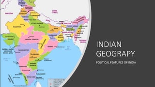
- 5. POLITICAL DIVISIONS OF INDIA • A large number of factors like geography, population, local cultures, languages and administrative convenience are the considerations for the political divisions of India. • India is divided into 28 states and 8 Union Territories. • The Union Territories are federally administered territories.
- 6. POLITICAL BACKGROUND • In 1947, India gained independence. • The Indian sub-continent was partitioned into India and Pakistan. • Pakistan was made up of two wings – West Pakistan and East Pakistan. • In 1971, East Pakistan separated from Pakistan and formed the independent country of Bangladesh.
- 7. LOCATION AND SIZE • India is centrally located in South Asia, at the head of the Indian Ocean. To the east is the peninsular of Indo-China and on the west is the peninsula of Arabia.
- 8. SIZE • India has an area of 3.2 million sq. km., making the seventh largest country in the world. The distance between the northern most part and the southernmost part of India is approximately 3214 km. The east- west extent also measures about 2933 km.
- 9. BOUNDARIES • India is a peninsula surrounded by water on three sides. It lies the head of the Indian Ocean with the Arabian Sea to the west and the Bay of Bengal on the east. • India is bordered by the countries of Pakistan, China, Nepal, Bhutan, Myanmar and Bangladesh. The island of Sri Lanka lies to the south of India, separated from it by the Palk Strait and the Gulf of Mannar.
- 10. COASTLINE India has a fairly regular coastline. That is why India does not have many natural harbours. The Gulf of Kachchh and the Gulf of Khambhat are found along the coast of Gujarat. Lake Chilka is found along the east coast of Orissa.
- 11. ISLANDS • The Andamans and the Nicobar Islands lie in the Bay of Bengal between latitudes 60 N and 140 N. • They are a group of many islands, some of them too small to be inhabited. Many of the islands are of volcanic origin. • The Lakshadweep is a group of islands in the Arabian Sea made up of Laccadive, Minicoy, Amindivi and many smaller islands. Most of the islands are of coral origin.
- 12. NOTE • Kanyakumari (also known as Cape Comorin) is the southern-most point of the Indian mainland. • The Bay of Bengal, the Indian Ocean and the Arabian Sea meet here. The beach sands are of different colours since they are deposited from different directions. • Kanyakumari is known for its spectacular sunrise, sunset and moonrise. Associated with the Goddess Kumari, Kanyakumari is a busy pilgrimage centre. • Indira Point is the Southern-most point of India. It is a part of the Andaman and Nicobar group of Islands.