SlideShare a Scribd company logo
1 of 2
National Aeronautics and
Space Administration
Water:
Sustaining Life
NASA–ISRO SAR Mission
NISAR will measure changes in groundwater over the Earth’s
vulnerable arid regions.
Over-exploitation of groundwater leads to lowering of the water
table and, in alluvial basins, compaction of aquifers leading to
sinking of the land surface (subsidence). Subsidence is often the
first indication of over-exploitation and can also cause problems
for infrastructure such as aqueducts, flood-control projects,
highways, bridges, and railways. If subsidence continues for too
long, it can lead to irreversible collapse of the aquifer system,
reducing its ability to recharge when water is available.
Understanding Aquifer Dynamics
Mapping and monitoring changes
in land surface elevation with
interferometric synthetic aperture
radar (InSAR) may help fill in the gaps
between monitoring wells. The ability
to map surface deformation of a few
millimeters monthly over large areas at
resolutions of a few tens of meters has
opened up new possibilities for remote
monitoring of groundwater resources.
Managing Water Resources
Water is necessary for life, both for drinking and for growing
food. In the more arid parts of the world, rainfall and surface
water can’t satisfy the growing demands of the people who live
in those regions. Groundwater makes up the difference, acting
as a reservoir that can be tapped through wells. Unfortunately,
climate change coupled with growing populations is causing
increasing stress on groundwater resources around the world.
The NISAR Mission — All-Weather Day and Night Imaging
Orbiting radar captures the extent and motions of land and sea ice over time and with enough detail to
reveal subtle changes. Radar penetrates clouds and operates day and night. It produces images that
are detailed enough to see local changes, and has broad enough coverage to measure regional trends.
The NASA–ISRO SAR (NISAR) mission will acquire images of surface changes globally with millimeter
accuracy and meter-scale resolution. It will capture images of the movements of the Earth over time
and with sufficient detail to reveal what is happening below the surface. Rapid sampling over years
to decades will allow for understanding groundwater dynamics. The detailed observations will reveal
information about the migration of water and the state of aquifers.
continued on back page
TO REDRAW
Area of Land Subsidence
Artist’s concept
For more information, visit: http://nisar.jpl.nasa.gov
JPL 400-1598 Rev. 1 12/16
National Aeronautics and Space Administration
Jet Propulsion Laboratory
California Institute of Technology
Pasadena, California
www.nasa.gov
Subsidence As a Measure of Groundwater Depletion
Water resource managers need to measure areas of continuing
subsidence and detect new regions of compaction in order
to adapt to changing water supply conditions and preserve
the integrity of the aquifers for future generations. Subsidence
permanently damages the aquifer, decreasing the amount
of water that can be stored. Land subsidence is typically
measured though periodic leveling or GPS surveys along with
limited monitoring wells, but the lack of frequent measurements
and the difficulty of mandating measurements at private wells
result in datasets that are sparse in space and time. NISAR will
provide systematic measurement across entire aquifers.
Managing Water Globally
NISAR offers the promise of detecting and measuring changes
to the land surface height above nearly every aquifer in the
world. This will provide information for large segments of the
global population that depend on groundwater to bridge gaps in
surface and rain water supply. It may allow us for the first time to
indirectly measure the volume of groundwater that is pumped and
recharged around the world. This will become more important
as Earth’s changing climate and the growing global population
outpaces the world’s supply of fresh water in aquifers.
Another capability of NISAR is its ability to easily identify and
map the extent of surface water in lakes and rivers. NISAR can
be used to track floods, even under cloud cover and vegetation
canopies. In some cases, NISAR can be used to measure
changes in the water surface height as water levels change with
rainfall, evaporation, and usage.
continued from front page
Copyright 2016 California Institute of Technology. U.S. Government sponsorship acknowledged.
Monitoring Subsidence
Total subsidence in the San Joaquin Valley, California, from 2007 to 2011 measured by InSAR. The subsidence bowl
to the north, just south of Merced, is a relatively recent feature caused by a change from row crops to trees, which
use more groundwater. Note how the California Aqueduct (purple) and the proposed High Speed Rail (blue) are both
affected by subsidence. NISAR will provide this information on a regular basis.

More Related Content

Similar to NISAR ( NASA-ISRO Synthetic Aperture Radar (NISAR) ) Water

NISAR NASA-ISRO Synthetic Aperture Radar (NISAR) Ice Sheets, Glaciers, and Oc...
NISAR NASA-ISRO Synthetic Aperture Radar (NISAR) Ice Sheets, Glaciers, and Oc...NISAR NASA-ISRO Synthetic Aperture Radar (NISAR) Ice Sheets, Glaciers, and Oc...
NISAR NASA-ISRO Synthetic Aperture Radar (NISAR) Ice Sheets, Glaciers, and Oc...Dr. Pankaj Dhussa
 
IRJET- Hydrological Modeling of Penganga Sub-Basin using Arc-SWAT
IRJET- Hydrological Modeling of Penganga Sub-Basin using Arc-SWATIRJET- Hydrological Modeling of Penganga Sub-Basin using Arc-SWAT
IRJET- Hydrological Modeling of Penganga Sub-Basin using Arc-SWATIRJET Journal
 
NISAR NASA-ISRO Synthetic Aperture Radar (NISAR) Sinkholes and Cavern Collapse
NISAR NASA-ISRO Synthetic Aperture Radar (NISAR) Sinkholes and Cavern CollapseNISAR NASA-ISRO Synthetic Aperture Radar (NISAR) Sinkholes and Cavern Collapse
NISAR NASA-ISRO Synthetic Aperture Radar (NISAR) Sinkholes and Cavern CollapseDr. Pankaj Dhussa
 
Bv31291295
Bv31291295Bv31291295
Bv31291295IJMER
 
NISAR NASA-ISRO Synthetic Aperture Radar (NISAR) Cryosphere
NISAR NASA-ISRO Synthetic Aperture Radar (NISAR) CryosphereNISAR NASA-ISRO Synthetic Aperture Radar (NISAR) Cryosphere
NISAR NASA-ISRO Synthetic Aperture Radar (NISAR) CryosphereDr. Pankaj Dhussa
 
SWOT_Fu_2011_IGARSS.ppt
SWOT_Fu_2011_IGARSS.pptSWOT_Fu_2011_IGARSS.ppt
SWOT_Fu_2011_IGARSS.pptgrssieee
 
Aquifer Mapping, Moni-ppt.pptx
Aquifer Mapping, Moni-ppt.pptxAquifer Mapping, Moni-ppt.pptx
Aquifer Mapping, Moni-ppt.pptxTejasKadam44
 
Dr. Jay Famiglietti - 21st Century Water Security and Implications for Animal...
Dr. Jay Famiglietti - 21st Century Water Security and Implications for Animal...Dr. Jay Famiglietti - 21st Century Water Security and Implications for Animal...
Dr. Jay Famiglietti - 21st Century Water Security and Implications for Animal...John Blue
 
WE1.L09 - AN OVERVIEW OF THE DESDYNI MISSION
WE1.L09 - AN OVERVIEW OF THE DESDYNI MISSIONWE1.L09 - AN OVERVIEW OF THE DESDYNI MISSION
WE1.L09 - AN OVERVIEW OF THE DESDYNI MISSIONgrssieee
 
#36068 Topic SCI 207 Our Dependence upon the EnvironmentNumber.docx
#36068 Topic SCI 207 Our Dependence upon the EnvironmentNumber.docx#36068 Topic SCI 207 Our Dependence upon the EnvironmentNumber.docx
#36068 Topic SCI 207 Our Dependence upon the EnvironmentNumber.docxAASTHA76
 
Investigation of groundwater flow direction using Geospatial technology: A ca...
Investigation of groundwater flow direction using Geospatial technology: A ca...Investigation of groundwater flow direction using Geospatial technology: A ca...
Investigation of groundwater flow direction using Geospatial technology: A ca...AI Publications
 
Stream MorphologyInvestigation ManualENVIRONMENTAL SCI.docx
Stream MorphologyInvestigation ManualENVIRONMENTAL SCI.docxStream MorphologyInvestigation ManualENVIRONMENTAL SCI.docx
Stream MorphologyInvestigation ManualENVIRONMENTAL SCI.docxcpatriciarpatricia
 
Stream MorphologyInvestigation ManualENVIRONMENTAL SCI.docx
Stream MorphologyInvestigation ManualENVIRONMENTAL SCI.docxStream MorphologyInvestigation ManualENVIRONMENTAL SCI.docx
Stream MorphologyInvestigation ManualENVIRONMENTAL SCI.docxsusanschei
 
NISAR NASA-ISRO Synthetic Aperture Radar (NISAR) Marine Hazards
NISAR NASA-ISRO Synthetic Aperture Radar (NISAR) Marine HazardsNISAR NASA-ISRO Synthetic Aperture Radar (NISAR) Marine Hazards
NISAR NASA-ISRO Synthetic Aperture Radar (NISAR) Marine HazardsDr. Pankaj Dhussa
 
TU2.L10 - THE AQUARIUS/SAC-D MISSION OVERVIEW
TU2.L10 - THE AQUARIUS/SAC-D MISSION OVERVIEWTU2.L10 - THE AQUARIUS/SAC-D MISSION OVERVIEW
TU2.L10 - THE AQUARIUS/SAC-D MISSION OVERVIEWgrssieee
 
IGARSS 2011_Temimi.pptx
IGARSS 2011_Temimi.pptxIGARSS 2011_Temimi.pptx
IGARSS 2011_Temimi.pptxgrssieee
 

Similar to NISAR ( NASA-ISRO Synthetic Aperture Radar (NISAR) ) Water (20)

NISAR NASA-ISRO Synthetic Aperture Radar (NISAR) Ice Sheets, Glaciers, and Oc...
NISAR NASA-ISRO Synthetic Aperture Radar (NISAR) Ice Sheets, Glaciers, and Oc...NISAR NASA-ISRO Synthetic Aperture Radar (NISAR) Ice Sheets, Glaciers, and Oc...
NISAR NASA-ISRO Synthetic Aperture Radar (NISAR) Ice Sheets, Glaciers, and Oc...
 
IRJET- Hydrological Modeling of Penganga Sub-Basin using Arc-SWAT
IRJET- Hydrological Modeling of Penganga Sub-Basin using Arc-SWATIRJET- Hydrological Modeling of Penganga Sub-Basin using Arc-SWAT
IRJET- Hydrological Modeling of Penganga Sub-Basin using Arc-SWAT
 
NISAR NASA-ISRO Synthetic Aperture Radar (NISAR) Sinkholes and Cavern Collapse
NISAR NASA-ISRO Synthetic Aperture Radar (NISAR) Sinkholes and Cavern CollapseNISAR NASA-ISRO Synthetic Aperture Radar (NISAR) Sinkholes and Cavern Collapse
NISAR NASA-ISRO Synthetic Aperture Radar (NISAR) Sinkholes and Cavern Collapse
 
Bv31291295
Bv31291295Bv31291295
Bv31291295
 
Impact of climate on groundwater
Impact of climate on groundwaterImpact of climate on groundwater
Impact of climate on groundwater
 
NISAR NASA-ISRO Synthetic Aperture Radar (NISAR) Cryosphere
NISAR NASA-ISRO Synthetic Aperture Radar (NISAR) CryosphereNISAR NASA-ISRO Synthetic Aperture Radar (NISAR) Cryosphere
NISAR NASA-ISRO Synthetic Aperture Radar (NISAR) Cryosphere
 
SWOT_Fu_2011_IGARSS.ppt
SWOT_Fu_2011_IGARSS.pptSWOT_Fu_2011_IGARSS.ppt
SWOT_Fu_2011_IGARSS.ppt
 
Aquifer Mapping, Moni-ppt.pptx
Aquifer Mapping, Moni-ppt.pptxAquifer Mapping, Moni-ppt.pptx
Aquifer Mapping, Moni-ppt.pptx
 
Dr. Jay Famiglietti - 21st Century Water Security and Implications for Animal...
Dr. Jay Famiglietti - 21st Century Water Security and Implications for Animal...Dr. Jay Famiglietti - 21st Century Water Security and Implications for Animal...
Dr. Jay Famiglietti - 21st Century Water Security and Implications for Animal...
 
fs20163037
fs20163037fs20163037
fs20163037
 
WE1.L09 - AN OVERVIEW OF THE DESDYNI MISSION
WE1.L09 - AN OVERVIEW OF THE DESDYNI MISSIONWE1.L09 - AN OVERVIEW OF THE DESDYNI MISSION
WE1.L09 - AN OVERVIEW OF THE DESDYNI MISSION
 
Awra poster
Awra posterAwra poster
Awra poster
 
#36068 Topic SCI 207 Our Dependence upon the EnvironmentNumber.docx
#36068 Topic SCI 207 Our Dependence upon the EnvironmentNumber.docx#36068 Topic SCI 207 Our Dependence upon the EnvironmentNumber.docx
#36068 Topic SCI 207 Our Dependence upon the EnvironmentNumber.docx
 
Investigation of groundwater flow direction using Geospatial technology: A ca...
Investigation of groundwater flow direction using Geospatial technology: A ca...Investigation of groundwater flow direction using Geospatial technology: A ca...
Investigation of groundwater flow direction using Geospatial technology: A ca...
 
L1 introduction
L1 introductionL1 introduction
L1 introduction
 
Stream MorphologyInvestigation ManualENVIRONMENTAL SCI.docx
Stream MorphologyInvestigation ManualENVIRONMENTAL SCI.docxStream MorphologyInvestigation ManualENVIRONMENTAL SCI.docx
Stream MorphologyInvestigation ManualENVIRONMENTAL SCI.docx
 
Stream MorphologyInvestigation ManualENVIRONMENTAL SCI.docx
Stream MorphologyInvestigation ManualENVIRONMENTAL SCI.docxStream MorphologyInvestigation ManualENVIRONMENTAL SCI.docx
Stream MorphologyInvestigation ManualENVIRONMENTAL SCI.docx
 
NISAR NASA-ISRO Synthetic Aperture Radar (NISAR) Marine Hazards
NISAR NASA-ISRO Synthetic Aperture Radar (NISAR) Marine HazardsNISAR NASA-ISRO Synthetic Aperture Radar (NISAR) Marine Hazards
NISAR NASA-ISRO Synthetic Aperture Radar (NISAR) Marine Hazards
 
TU2.L10 - THE AQUARIUS/SAC-D MISSION OVERVIEW
TU2.L10 - THE AQUARIUS/SAC-D MISSION OVERVIEWTU2.L10 - THE AQUARIUS/SAC-D MISSION OVERVIEW
TU2.L10 - THE AQUARIUS/SAC-D MISSION OVERVIEW
 
IGARSS 2011_Temimi.pptx
IGARSS 2011_Temimi.pptxIGARSS 2011_Temimi.pptx
IGARSS 2011_Temimi.pptx
 

More from Dr. Pankaj Dhussa

NASA Public Perception: Community Response to X-59 Quesst Mission: Phase 3
NASA Public Perception: Community Response to X-59 Quesst Mission: Phase 3NASA Public Perception: Community Response to X-59 Quesst Mission: Phase 3
NASA Public Perception: Community Response to X-59 Quesst Mission: Phase 3Dr. Pankaj Dhussa
 
NASA Overcoming the 50-Year Ban History of the Ban on Commercial Supersonic F...
NASA Overcoming the 50-Year Ban History of the Ban on Commercial Supersonic F...NASA Overcoming the 50-Year Ban History of the Ban on Commercial Supersonic F...
NASA Overcoming the 50-Year Ban History of the Ban on Commercial Supersonic F...Dr. Pankaj Dhussa
 
NASA Flight Demonstration and Capabilities Quesst Phase 3 Flight Operations
NASA Flight Demonstration and Capabilities Quesst Phase 3 Flight OperationsNASA Flight Demonstration and Capabilities Quesst Phase 3 Flight Operations
NASA Flight Demonstration and Capabilities Quesst Phase 3 Flight OperationsDr. Pankaj Dhussa
 
NASA Carbon Fiber Composites (CFC) Recycling Technology Enabled by the TuFF T...
NASA Carbon Fiber Composites (CFC) Recycling Technology Enabled by the TuFF T...NASA Carbon Fiber Composites (CFC) Recycling Technology Enabled by the TuFF T...
NASA Carbon Fiber Composites (CFC) Recycling Technology Enabled by the TuFF T...Dr. Pankaj Dhussa
 
NASA Urban Air Mobility Fatigue Prediction Aaron Crawford – NASA ULI Innovati...
NASA Urban Air Mobility Fatigue Prediction Aaron Crawford – NASA ULI Innovati...NASA Urban Air Mobility Fatigue Prediction Aaron Crawford – NASA ULI Innovati...
NASA Urban Air Mobility Fatigue Prediction Aaron Crawford – NASA ULI Innovati...Dr. Pankaj Dhussa
 
NASA Automated Repair Approaches for AAM
NASA Automated Repair Approaches for AAMNASA Automated Repair Approaches for AAM
NASA Automated Repair Approaches for AAMDr. Pankaj Dhussa
 
NASA Multiscale Analysis Tool (NASMAT) Robust, Integrated, Physics-based, Non...
NASA Multiscale Analysis Tool (NASMAT) Robust, Integrated, Physics-based, Non...NASA Multiscale Analysis Tool (NASMAT) Robust, Integrated, Physics-based, Non...
NASA Multiscale Analysis Tool (NASMAT) Robust, Integrated, Physics-based, Non...Dr. Pankaj Dhussa
 
NASA Materials Informatics Enables Rapid Materials Discovery
NASA Materials Informatics Enables Rapid Materials DiscoveryNASA Materials Informatics Enables Rapid Materials Discovery
NASA Materials Informatics Enables Rapid Materials DiscoveryDr. Pankaj Dhussa
 
NASA CFD Vision 2030: The Power of Exascale Computing
NASA CFD Vision 2030: The Power of Exascale ComputingNASA CFD Vision 2030: The Power of Exascale Computing
NASA CFD Vision 2030: The Power of Exascale ComputingDr. Pankaj Dhussa
 
NASA High Lift Common Research Model (CRM-HL) Ecosystem
NASA High Lift Common Research Model (CRM-HL) EcosystemNASA High Lift Common Research Model (CRM-HL) Ecosystem
NASA High Lift Common Research Model (CRM-HL) EcosystemDr. Pankaj Dhussa
 
NASA Aviary Open-source software tool for optimizing next-generation aircraft...
NASA Aviary Open-source software tool for optimizing next-generation aircraft...NASA Aviary Open-source software tool for optimizing next-generation aircraft...
NASA Aviary Open-source software tool for optimizing next-generation aircraft...Dr. Pankaj Dhussa
 
NASA Aircraft Certification by Analysis (CbA) 20-year Vision for Virtual Flig...
NASA Aircraft Certification by Analysis (CbA) 20-year Vision for Virtual Flig...NASA Aircraft Certification by Analysis (CbA) 20-year Vision for Virtual Flig...
NASA Aircraft Certification by Analysis (CbA) 20-year Vision for Virtual Flig...Dr. Pankaj Dhussa
 
NASA Self-Aligned Focusing Schlieren (SAFS) Flow Visualization Technique
NASA Self-Aligned Focusing Schlieren (SAFS) Flow Visualization TechniqueNASA Self-Aligned Focusing Schlieren (SAFS) Flow Visualization Technique
NASA Self-Aligned Focusing Schlieren (SAFS) Flow Visualization TechniqueDr. Pankaj Dhussa
 
NASA DECO CAS Research into a New Operating Mode for Digitally Enabled Cooper...
NASA DECO CAS Research into a New Operating Mode for Digitally Enabled Cooper...NASA DECO CAS Research into a New Operating Mode for Digitally Enabled Cooper...
NASA DECO CAS Research into a New Operating Mode for Digitally Enabled Cooper...Dr. Pankaj Dhussa
 
NASA Advanced Exploration of Reliable Operation at low Altitudes: meteorology...
NASA Advanced Exploration of Reliable Operation at low Altitudes: meteorology...NASA Advanced Exploration of Reliable Operation at low Altitudes: meteorology...
NASA Advanced Exploration of Reliable Operation at low Altitudes: meteorology...Dr. Pankaj Dhussa
 
NASA Self-Adaptation of Loosely Coupled Systems across a System of Small Uncr...
NASA Self-Adaptation of Loosely Coupled Systems across a System of Small Uncr...NASA Self-Adaptation of Loosely Coupled Systems across a System of Small Uncr...
NASA Self-Adaptation of Loosely Coupled Systems across a System of Small Uncr...Dr. Pankaj Dhussa
 
NASA Safety Case Approach for Automated Flight Authorization System
NASA Safety Case Approach for Automated Flight Authorization SystemNASA Safety Case Approach for Automated Flight Authorization System
NASA Safety Case Approach for Automated Flight Authorization SystemDr. Pankaj Dhussa
 
NASA RealWindDroneSim (RWDS) Enhancing Simulation Fidelity of small Uncrewed ...
NASA RealWindDroneSim (RWDS) Enhancing Simulation Fidelity of small Uncrewed ...NASA RealWindDroneSim (RWDS) Enhancing Simulation Fidelity of small Uncrewed ...
NASA RealWindDroneSim (RWDS) Enhancing Simulation Fidelity of small Uncrewed ...Dr. Pankaj Dhussa
 
NASA ARMD Test Data Portal (ATDP) Agile Development Method Introduction of an...
NASA ARMD Test Data Portal (ATDP) Agile Development Method Introduction of an...NASA ARMD Test Data Portal (ATDP) Agile Development Method Introduction of an...
NASA ARMD Test Data Portal (ATDP) Agile Development Method Introduction of an...Dr. Pankaj Dhussa
 
NASA ARMD Test Data Portal (ATDP) he ARMD Test Data Portal (ATDP) is a secure...
NASA ARMD Test Data Portal (ATDP) he ARMD Test Data Portal (ATDP) is a secure...NASA ARMD Test Data Portal (ATDP) he ARMD Test Data Portal (ATDP) is a secure...
NASA ARMD Test Data Portal (ATDP) he ARMD Test Data Portal (ATDP) is a secure...Dr. Pankaj Dhussa
 

More from Dr. Pankaj Dhussa (20)

NASA Public Perception: Community Response to X-59 Quesst Mission: Phase 3
NASA Public Perception: Community Response to X-59 Quesst Mission: Phase 3NASA Public Perception: Community Response to X-59 Quesst Mission: Phase 3
NASA Public Perception: Community Response to X-59 Quesst Mission: Phase 3
 
NASA Overcoming the 50-Year Ban History of the Ban on Commercial Supersonic F...
NASA Overcoming the 50-Year Ban History of the Ban on Commercial Supersonic F...NASA Overcoming the 50-Year Ban History of the Ban on Commercial Supersonic F...
NASA Overcoming the 50-Year Ban History of the Ban on Commercial Supersonic F...
 
NASA Flight Demonstration and Capabilities Quesst Phase 3 Flight Operations
NASA Flight Demonstration and Capabilities Quesst Phase 3 Flight OperationsNASA Flight Demonstration and Capabilities Quesst Phase 3 Flight Operations
NASA Flight Demonstration and Capabilities Quesst Phase 3 Flight Operations
 
NASA Carbon Fiber Composites (CFC) Recycling Technology Enabled by the TuFF T...
NASA Carbon Fiber Composites (CFC) Recycling Technology Enabled by the TuFF T...NASA Carbon Fiber Composites (CFC) Recycling Technology Enabled by the TuFF T...
NASA Carbon Fiber Composites (CFC) Recycling Technology Enabled by the TuFF T...
 
NASA Urban Air Mobility Fatigue Prediction Aaron Crawford – NASA ULI Innovati...
NASA Urban Air Mobility Fatigue Prediction Aaron Crawford – NASA ULI Innovati...NASA Urban Air Mobility Fatigue Prediction Aaron Crawford – NASA ULI Innovati...
NASA Urban Air Mobility Fatigue Prediction Aaron Crawford – NASA ULI Innovati...
 
NASA Automated Repair Approaches for AAM
NASA Automated Repair Approaches for AAMNASA Automated Repair Approaches for AAM
NASA Automated Repair Approaches for AAM
 
NASA Multiscale Analysis Tool (NASMAT) Robust, Integrated, Physics-based, Non...
NASA Multiscale Analysis Tool (NASMAT) Robust, Integrated, Physics-based, Non...NASA Multiscale Analysis Tool (NASMAT) Robust, Integrated, Physics-based, Non...
NASA Multiscale Analysis Tool (NASMAT) Robust, Integrated, Physics-based, Non...
 
NASA Materials Informatics Enables Rapid Materials Discovery
NASA Materials Informatics Enables Rapid Materials DiscoveryNASA Materials Informatics Enables Rapid Materials Discovery
NASA Materials Informatics Enables Rapid Materials Discovery
 
NASA CFD Vision 2030: The Power of Exascale Computing
NASA CFD Vision 2030: The Power of Exascale ComputingNASA CFD Vision 2030: The Power of Exascale Computing
NASA CFD Vision 2030: The Power of Exascale Computing
 
NASA High Lift Common Research Model (CRM-HL) Ecosystem
NASA High Lift Common Research Model (CRM-HL) EcosystemNASA High Lift Common Research Model (CRM-HL) Ecosystem
NASA High Lift Common Research Model (CRM-HL) Ecosystem
 
NASA Aviary Open-source software tool for optimizing next-generation aircraft...
NASA Aviary Open-source software tool for optimizing next-generation aircraft...NASA Aviary Open-source software tool for optimizing next-generation aircraft...
NASA Aviary Open-source software tool for optimizing next-generation aircraft...
 
NASA Aircraft Certification by Analysis (CbA) 20-year Vision for Virtual Flig...
NASA Aircraft Certification by Analysis (CbA) 20-year Vision for Virtual Flig...NASA Aircraft Certification by Analysis (CbA) 20-year Vision for Virtual Flig...
NASA Aircraft Certification by Analysis (CbA) 20-year Vision for Virtual Flig...
 
NASA Self-Aligned Focusing Schlieren (SAFS) Flow Visualization Technique
NASA Self-Aligned Focusing Schlieren (SAFS) Flow Visualization TechniqueNASA Self-Aligned Focusing Schlieren (SAFS) Flow Visualization Technique
NASA Self-Aligned Focusing Schlieren (SAFS) Flow Visualization Technique
 
NASA DECO CAS Research into a New Operating Mode for Digitally Enabled Cooper...
NASA DECO CAS Research into a New Operating Mode for Digitally Enabled Cooper...NASA DECO CAS Research into a New Operating Mode for Digitally Enabled Cooper...
NASA DECO CAS Research into a New Operating Mode for Digitally Enabled Cooper...
 
NASA Advanced Exploration of Reliable Operation at low Altitudes: meteorology...
NASA Advanced Exploration of Reliable Operation at low Altitudes: meteorology...NASA Advanced Exploration of Reliable Operation at low Altitudes: meteorology...
NASA Advanced Exploration of Reliable Operation at low Altitudes: meteorology...
 
NASA Self-Adaptation of Loosely Coupled Systems across a System of Small Uncr...
NASA Self-Adaptation of Loosely Coupled Systems across a System of Small Uncr...NASA Self-Adaptation of Loosely Coupled Systems across a System of Small Uncr...
NASA Self-Adaptation of Loosely Coupled Systems across a System of Small Uncr...
 
NASA Safety Case Approach for Automated Flight Authorization System
NASA Safety Case Approach for Automated Flight Authorization SystemNASA Safety Case Approach for Automated Flight Authorization System
NASA Safety Case Approach for Automated Flight Authorization System
 
NASA RealWindDroneSim (RWDS) Enhancing Simulation Fidelity of small Uncrewed ...
NASA RealWindDroneSim (RWDS) Enhancing Simulation Fidelity of small Uncrewed ...NASA RealWindDroneSim (RWDS) Enhancing Simulation Fidelity of small Uncrewed ...
NASA RealWindDroneSim (RWDS) Enhancing Simulation Fidelity of small Uncrewed ...
 
NASA ARMD Test Data Portal (ATDP) Agile Development Method Introduction of an...
NASA ARMD Test Data Portal (ATDP) Agile Development Method Introduction of an...NASA ARMD Test Data Portal (ATDP) Agile Development Method Introduction of an...
NASA ARMD Test Data Portal (ATDP) Agile Development Method Introduction of an...
 
NASA ARMD Test Data Portal (ATDP) he ARMD Test Data Portal (ATDP) is a secure...
NASA ARMD Test Data Portal (ATDP) he ARMD Test Data Portal (ATDP) is a secure...NASA ARMD Test Data Portal (ATDP) he ARMD Test Data Portal (ATDP) is a secure...
NASA ARMD Test Data Portal (ATDP) he ARMD Test Data Portal (ATDP) is a secure...
 

Recently uploaded

DBX First Quarter 2024 Investor Presentation
DBX First Quarter 2024 Investor PresentationDBX First Quarter 2024 Investor Presentation
DBX First Quarter 2024 Investor PresentationDropbox
 
MS Copilot expands with MS Graph connectors
MS Copilot expands with MS Graph connectorsMS Copilot expands with MS Graph connectors
MS Copilot expands with MS Graph connectorsNanddeep Nachan
 
Apidays New York 2024 - The value of a flexible API Management solution for O...
Apidays New York 2024 - The value of a flexible API Management solution for O...Apidays New York 2024 - The value of a flexible API Management solution for O...
Apidays New York 2024 - The value of a flexible API Management solution for O...apidays
 
Web Form Automation for Bonterra Impact Management (fka Social Solutions Apri...
Web Form Automation for Bonterra Impact Management (fka Social Solutions Apri...Web Form Automation for Bonterra Impact Management (fka Social Solutions Apri...
Web Form Automation for Bonterra Impact Management (fka Social Solutions Apri...Jeffrey Haguewood
 
Emergent Methods: Multi-lingual narrative tracking in the news - real-time ex...
Emergent Methods: Multi-lingual narrative tracking in the news - real-time ex...Emergent Methods: Multi-lingual narrative tracking in the news - real-time ex...
Emergent Methods: Multi-lingual narrative tracking in the news - real-time ex...Zilliz
 
Modular Monolith - a Practical Alternative to Microservices @ Devoxx UK 2024
Modular Monolith - a Practical Alternative to Microservices @ Devoxx UK 2024Modular Monolith - a Practical Alternative to Microservices @ Devoxx UK 2024
Modular Monolith - a Practical Alternative to Microservices @ Devoxx UK 2024Victor Rentea
 
MINDCTI Revenue Release Quarter One 2024
MINDCTI Revenue Release Quarter One 2024MINDCTI Revenue Release Quarter One 2024
MINDCTI Revenue Release Quarter One 2024MIND CTI
 
How to Troubleshoot Apps for the Modern Connected Worker
How to Troubleshoot Apps for the Modern Connected WorkerHow to Troubleshoot Apps for the Modern Connected Worker
How to Troubleshoot Apps for the Modern Connected WorkerThousandEyes
 
Apidays New York 2024 - The Good, the Bad and the Governed by David O'Neill, ...
Apidays New York 2024 - The Good, the Bad and the Governed by David O'Neill, ...Apidays New York 2024 - The Good, the Bad and the Governed by David O'Neill, ...
Apidays New York 2024 - The Good, the Bad and the Governed by David O'Neill, ...apidays
 
Biography Of Angeliki Cooney | Senior Vice President Life Sciences | Albany, ...
Biography Of Angeliki Cooney | Senior Vice President Life Sciences | Albany, ...Biography Of Angeliki Cooney | Senior Vice President Life Sciences | Albany, ...
Biography Of Angeliki Cooney | Senior Vice President Life Sciences | Albany, ...Angeliki Cooney
 
Strategies for Landing an Oracle DBA Job as a Fresher
Strategies for Landing an Oracle DBA Job as a FresherStrategies for Landing an Oracle DBA Job as a Fresher
Strategies for Landing an Oracle DBA Job as a FresherRemote DBA Services
 
Connector Corner: Accelerate revenue generation using UiPath API-centric busi...
Connector Corner: Accelerate revenue generation using UiPath API-centric busi...Connector Corner: Accelerate revenue generation using UiPath API-centric busi...
Connector Corner: Accelerate revenue generation using UiPath API-centric busi...DianaGray10
 
Polkadot JAM Slides - Token2049 - By Dr. Gavin Wood
Polkadot JAM Slides - Token2049 - By Dr. Gavin WoodPolkadot JAM Slides - Token2049 - By Dr. Gavin Wood
Polkadot JAM Slides - Token2049 - By Dr. Gavin WoodJuan lago vázquez
 
Exploring the Future Potential of AI-Enabled Smartphone Processors
Exploring the Future Potential of AI-Enabled Smartphone ProcessorsExploring the Future Potential of AI-Enabled Smartphone Processors
Exploring the Future Potential of AI-Enabled Smartphone Processorsdebabhi2
 
Spring Boot vs Quarkus the ultimate battle - DevoxxUK
Spring Boot vs Quarkus the ultimate battle - DevoxxUKSpring Boot vs Quarkus the ultimate battle - DevoxxUK
Spring Boot vs Quarkus the ultimate battle - DevoxxUKJago de Vreede
 
Cloud Frontiers: A Deep Dive into Serverless Spatial Data and FME
Cloud Frontiers:  A Deep Dive into Serverless Spatial Data and FMECloud Frontiers:  A Deep Dive into Serverless Spatial Data and FME
Cloud Frontiers: A Deep Dive into Serverless Spatial Data and FMESafe Software
 
Artificial Intelligence Chap.5 : Uncertainty
Artificial Intelligence Chap.5 : UncertaintyArtificial Intelligence Chap.5 : Uncertainty
Artificial Intelligence Chap.5 : UncertaintyKhushali Kathiriya
 
Manulife - Insurer Transformation Award 2024
Manulife - Insurer Transformation Award 2024Manulife - Insurer Transformation Award 2024
Manulife - Insurer Transformation Award 2024The Digital Insurer
 
TrustArc Webinar - Unlock the Power of AI-Driven Data Discovery
TrustArc Webinar - Unlock the Power of AI-Driven Data DiscoveryTrustArc Webinar - Unlock the Power of AI-Driven Data Discovery
TrustArc Webinar - Unlock the Power of AI-Driven Data DiscoveryTrustArc
 

Recently uploaded (20)

DBX First Quarter 2024 Investor Presentation
DBX First Quarter 2024 Investor PresentationDBX First Quarter 2024 Investor Presentation
DBX First Quarter 2024 Investor Presentation
 
MS Copilot expands with MS Graph connectors
MS Copilot expands with MS Graph connectorsMS Copilot expands with MS Graph connectors
MS Copilot expands with MS Graph connectors
 
Apidays New York 2024 - The value of a flexible API Management solution for O...
Apidays New York 2024 - The value of a flexible API Management solution for O...Apidays New York 2024 - The value of a flexible API Management solution for O...
Apidays New York 2024 - The value of a flexible API Management solution for O...
 
Web Form Automation for Bonterra Impact Management (fka Social Solutions Apri...
Web Form Automation for Bonterra Impact Management (fka Social Solutions Apri...Web Form Automation for Bonterra Impact Management (fka Social Solutions Apri...
Web Form Automation for Bonterra Impact Management (fka Social Solutions Apri...
 
Emergent Methods: Multi-lingual narrative tracking in the news - real-time ex...
Emergent Methods: Multi-lingual narrative tracking in the news - real-time ex...Emergent Methods: Multi-lingual narrative tracking in the news - real-time ex...
Emergent Methods: Multi-lingual narrative tracking in the news - real-time ex...
 
Modular Monolith - a Practical Alternative to Microservices @ Devoxx UK 2024
Modular Monolith - a Practical Alternative to Microservices @ Devoxx UK 2024Modular Monolith - a Practical Alternative to Microservices @ Devoxx UK 2024
Modular Monolith - a Practical Alternative to Microservices @ Devoxx UK 2024
 
MINDCTI Revenue Release Quarter One 2024
MINDCTI Revenue Release Quarter One 2024MINDCTI Revenue Release Quarter One 2024
MINDCTI Revenue Release Quarter One 2024
 
How to Troubleshoot Apps for the Modern Connected Worker
How to Troubleshoot Apps for the Modern Connected WorkerHow to Troubleshoot Apps for the Modern Connected Worker
How to Troubleshoot Apps for the Modern Connected Worker
 
Apidays New York 2024 - The Good, the Bad and the Governed by David O'Neill, ...
Apidays New York 2024 - The Good, the Bad and the Governed by David O'Neill, ...Apidays New York 2024 - The Good, the Bad and the Governed by David O'Neill, ...
Apidays New York 2024 - The Good, the Bad and the Governed by David O'Neill, ...
 
Biography Of Angeliki Cooney | Senior Vice President Life Sciences | Albany, ...
Biography Of Angeliki Cooney | Senior Vice President Life Sciences | Albany, ...Biography Of Angeliki Cooney | Senior Vice President Life Sciences | Albany, ...
Biography Of Angeliki Cooney | Senior Vice President Life Sciences | Albany, ...
 
Strategies for Landing an Oracle DBA Job as a Fresher
Strategies for Landing an Oracle DBA Job as a FresherStrategies for Landing an Oracle DBA Job as a Fresher
Strategies for Landing an Oracle DBA Job as a Fresher
 
Connector Corner: Accelerate revenue generation using UiPath API-centric busi...
Connector Corner: Accelerate revenue generation using UiPath API-centric busi...Connector Corner: Accelerate revenue generation using UiPath API-centric busi...
Connector Corner: Accelerate revenue generation using UiPath API-centric busi...
 
Polkadot JAM Slides - Token2049 - By Dr. Gavin Wood
Polkadot JAM Slides - Token2049 - By Dr. Gavin WoodPolkadot JAM Slides - Token2049 - By Dr. Gavin Wood
Polkadot JAM Slides - Token2049 - By Dr. Gavin Wood
 
Exploring the Future Potential of AI-Enabled Smartphone Processors
Exploring the Future Potential of AI-Enabled Smartphone ProcessorsExploring the Future Potential of AI-Enabled Smartphone Processors
Exploring the Future Potential of AI-Enabled Smartphone Processors
 
Spring Boot vs Quarkus the ultimate battle - DevoxxUK
Spring Boot vs Quarkus the ultimate battle - DevoxxUKSpring Boot vs Quarkus the ultimate battle - DevoxxUK
Spring Boot vs Quarkus the ultimate battle - DevoxxUK
 
Cloud Frontiers: A Deep Dive into Serverless Spatial Data and FME
Cloud Frontiers:  A Deep Dive into Serverless Spatial Data and FMECloud Frontiers:  A Deep Dive into Serverless Spatial Data and FME
Cloud Frontiers: A Deep Dive into Serverless Spatial Data and FME
 
Artificial Intelligence Chap.5 : Uncertainty
Artificial Intelligence Chap.5 : UncertaintyArtificial Intelligence Chap.5 : Uncertainty
Artificial Intelligence Chap.5 : Uncertainty
 
Manulife - Insurer Transformation Award 2024
Manulife - Insurer Transformation Award 2024Manulife - Insurer Transformation Award 2024
Manulife - Insurer Transformation Award 2024
 
+971581248768>> SAFE AND ORIGINAL ABORTION PILLS FOR SALE IN DUBAI AND ABUDHA...
+971581248768>> SAFE AND ORIGINAL ABORTION PILLS FOR SALE IN DUBAI AND ABUDHA...+971581248768>> SAFE AND ORIGINAL ABORTION PILLS FOR SALE IN DUBAI AND ABUDHA...
+971581248768>> SAFE AND ORIGINAL ABORTION PILLS FOR SALE IN DUBAI AND ABUDHA...
 
TrustArc Webinar - Unlock the Power of AI-Driven Data Discovery
TrustArc Webinar - Unlock the Power of AI-Driven Data DiscoveryTrustArc Webinar - Unlock the Power of AI-Driven Data Discovery
TrustArc Webinar - Unlock the Power of AI-Driven Data Discovery
 

NISAR ( NASA-ISRO Synthetic Aperture Radar (NISAR) ) Water

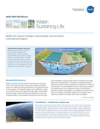
  • 1. National Aeronautics and Space Administration Water: Sustaining Life NASA–ISRO SAR Mission NISAR will measure changes in groundwater over the Earth’s vulnerable arid regions. Over-exploitation of groundwater leads to lowering of the water table and, in alluvial basins, compaction of aquifers leading to sinking of the land surface (subsidence). Subsidence is often the first indication of over-exploitation and can also cause problems for infrastructure such as aqueducts, flood-control projects, highways, bridges, and railways. If subsidence continues for too long, it can lead to irreversible collapse of the aquifer system, reducing its ability to recharge when water is available. Understanding Aquifer Dynamics Mapping and monitoring changes in land surface elevation with interferometric synthetic aperture radar (InSAR) may help fill in the gaps between monitoring wells. The ability to map surface deformation of a few millimeters monthly over large areas at resolutions of a few tens of meters has opened up new possibilities for remote monitoring of groundwater resources. Managing Water Resources Water is necessary for life, both for drinking and for growing food. In the more arid parts of the world, rainfall and surface water can’t satisfy the growing demands of the people who live in those regions. Groundwater makes up the difference, acting as a reservoir that can be tapped through wells. Unfortunately, climate change coupled with growing populations is causing increasing stress on groundwater resources around the world. The NISAR Mission — All-Weather Day and Night Imaging Orbiting radar captures the extent and motions of land and sea ice over time and with enough detail to reveal subtle changes. Radar penetrates clouds and operates day and night. It produces images that are detailed enough to see local changes, and has broad enough coverage to measure regional trends. The NASA–ISRO SAR (NISAR) mission will acquire images of surface changes globally with millimeter accuracy and meter-scale resolution. It will capture images of the movements of the Earth over time and with sufficient detail to reveal what is happening below the surface. Rapid sampling over years to decades will allow for understanding groundwater dynamics. The detailed observations will reveal information about the migration of water and the state of aquifers. continued on back page TO REDRAW Area of Land Subsidence Artist’s concept
  • 2. For more information, visit: http://nisar.jpl.nasa.gov JPL 400-1598 Rev. 1 12/16 National Aeronautics and Space Administration Jet Propulsion Laboratory California Institute of Technology Pasadena, California www.nasa.gov Subsidence As a Measure of Groundwater Depletion Water resource managers need to measure areas of continuing subsidence and detect new regions of compaction in order to adapt to changing water supply conditions and preserve the integrity of the aquifers for future generations. Subsidence permanently damages the aquifer, decreasing the amount of water that can be stored. Land subsidence is typically measured though periodic leveling or GPS surveys along with limited monitoring wells, but the lack of frequent measurements and the difficulty of mandating measurements at private wells result in datasets that are sparse in space and time. NISAR will provide systematic measurement across entire aquifers. Managing Water Globally NISAR offers the promise of detecting and measuring changes to the land surface height above nearly every aquifer in the world. This will provide information for large segments of the global population that depend on groundwater to bridge gaps in surface and rain water supply. It may allow us for the first time to indirectly measure the volume of groundwater that is pumped and recharged around the world. This will become more important as Earth’s changing climate and the growing global population outpaces the world’s supply of fresh water in aquifers. Another capability of NISAR is its ability to easily identify and map the extent of surface water in lakes and rivers. NISAR can be used to track floods, even under cloud cover and vegetation canopies. In some cases, NISAR can be used to measure changes in the water surface height as water levels change with rainfall, evaporation, and usage. continued from front page Copyright 2016 California Institute of Technology. U.S. Government sponsorship acknowledged. Monitoring Subsidence Total subsidence in the San Joaquin Valley, California, from 2007 to 2011 measured by InSAR. The subsidence bowl to the north, just south of Merced, is a relatively recent feature caused by a change from row crops to trees, which use more groundwater. Note how the California Aqueduct (purple) and the proposed High Speed Rail (blue) are both affected by subsidence. NISAR will provide this information on a regular basis.