
Recomendados
Mais conteúdo relacionado
Mais procurados
Mais procurados (20)
Destaque
Destaque (18)
Semelhante a US Weather Map Contour Lines
Semelhante a US Weather Map Contour Lines (20)
Mais de Lexume1
Mais de Lexume1 (20)
Último
Último (15)
US Weather Map Contour Lines
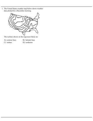
- 1. 1. The United States weather map below shows weather data plotted for a December morning. A) contour lines B) latitude lines C) isobars D) isotherms The isolines shown on the map most likely are
- 2. 2. Base your answer to the following question on the contour map below. Points A through F represent locations on the map. A) Rivers shown on maps generally flow southward. B) Rivers always flow toward large bodies of water. C) Contour lines bend upstream when crossing a river. D) A large body of water is generally the source of water for a river. If no elevation values were given, which general rule could be used to establish that Cedar River flows into Sunfish Lake?
- 3. 3. Base your answer to the following question on the topographic maps and block diagrams of two landscape regions shown below. The block diagrams show a three-dimensional view of the topographic maps directly above them. Elevations are measured in feet. Points A, B, C, and D are locations on Earth’s surface. A) B) C) D) A stream begins to flow downhill from point D toward the depression. After a period of time, the depression fills with water. Overflowing water from the depression moves downhill toward point C. Which topographic map shows the most likely resulting change in the contour lines?
- 4. Base your answers to questions 4 and 5 on the contour map below. Letters A through H represent locations in the area represented by the map. Contour lines are labeled in feet. 4. State how the shape of the contour lines crossing the Green River indicates that this river flows toward the southeast. 5. Which letter represents the highest elevation? 6. Base your answer to the following question on A topographic map of Mt. Rainier in Washington State is shown below. A) 20 ft B) 40 ft C) 100 ft D) 200 ft What is the contour interval of the map?
- 5. 7. Base your answer to the following question on the topographic map below, which shows three glaciers found in Alaska. Dashed lines show the inferred location of the front edge of each glacier in 1948, 1964, and 1980. Solid lines show the location of the front edge of each glacier in 1998. Points A and B show the location of the front edge of the Taku Glacier in 1948 and 1998. Elevations are in feet. What is the contour interval on this map?
- 6. 8. Base your answer to the following question on the topographic map below. Letters A through F represent locations on the map. A) 10 m B) 50 m C) 100 m D) 150 m What is the contour interval of this map? 9. Base your answer to the following question on the map below, which shows a portion of a drumlin field. Elevations are in feet. A) 5 ft B) 10 ft C) 20 ft D) 25 ft What is the contour interval of this map?
- 7. 10. Base your answer to the following question on the topographic map below. Points A through D are locations on the map. Elevations are in feet. Explain briefly how the map can be used to determine that Jones Creek is flowing westward into Jones Lake. A) A and B B) B and C C) C and D D) A and D 11. The diagram below is a contour map. Between which two points is the slope of the hill steepest? A) 12 m/km B) 40 m/km C) 120 m/km D) 160 m/km 12. A contour map shows two locations, X and Y, 5 kilometers apart. The elevation at location X is 800 meters and the elevation at location Y is 600 meters. What is the gradient between the two locations?
- 8. 13. Base your answer to the following question on the topographic map below. Points A through I are locations on the map. Elevations are shown in meters. A) northward out of Wolf Pond B) northward into Wolf Pond C) southward out of Wolf Pond D) southward into Wolf Pond The contour lines crossing Deer River show that the river flows
- 9. 14. Base your answer to the following question on the topographic map shown below. Letters A, B, C, D, and E represent locations on Earth's surface. Letters K, L, M, and N are locations along Copper Creek. Elevations are measured in meters.
- 11. 15. Base your answer to the following question on the topographic map below. Points A and B are reference points on the map. The symbols show the highest elevations on Eagle Hill and Timony Hill. Elevations are shown in feet. On the grid below, construct a topographic profile along line AB by plotting an X for the elevation of each contour line that crosses line AB. Connect the plotted Xs with a smooth, curved line to complete the profile. Points A and B have been plotted.
- 12. Base your answers to questions 16 and 17 on the topographic map below, which shows a small island in an ocean. Points A, B, C, and D represent surface locations on the island. The symbol 134 represents an elevation on the hilltop. Elevations are measured in feet and distances are measured in miles. 16. Explain how the contour lines on the map indicate that the north side of the island has the steepest slope. 17. On the grid below, construct a profile along line AB by plotting an X for the elevation of each contour line that crosses line AB. Connect the Xs with a smooth, curved line to complete the profile.
- 13. Base your answers to questions 18 and 19 on the reading passage and topographic map below. A group of Earth science students decided to take an adventurous camping trip, so they rode bicycles to a state park that was located in an isolated area. They traveled up a steep hill. When they reached the top, they looked at the landscape and noticed a lake at the bottom of the hill. They named it Hidden Lake. To the left of Hidden Lake was a large field with a small stream. They decided to set up their campsite in the field near Hidden Lake. To get to the field, they cycled down a very steep slope. The map below shows the location of the bicycle trail and the students' campsite. Points P and Q are reference points on the map. 18. State the evidence shown on the map that indicates that the area directly north of Hidden Lake is relatively flat. 19. On the grid provided above, draw a profile of the landscape along the bicycle trail from point P to point Q by following the directions below. a Plot the elevation along line PQ by marking with a dot each point where a contour line is crossed by line PQ. Point P and point Q have been plotted for you. b Connect the dots to complete the profile.
- 14. 20. Base your answer to the following question on the topographic map of an island shown below. Elevations are expressed in feet. Points A, B, C, and D are locations on the island. A triangulation point shows the highest elevation on the island. On the grid provided above, construct a topographic profile representing the cross-sectional view between point A and point B, following the directions below. a Plot the elevation of the land along line AB by marking, with a dot, the elevation of each point where a contour line is crossed by line AB. b Connect the dots with a smooth, curved line to complete the topographic profile.
- 15. Base your answers to questions 21 and 22 on the topographic map below. Points A, B, Y, and Z are reference points on the topographic map. The symbol 533 represents the highest elevation on Aurora Hill. 21. Describe the evidence shown on the map that indicates that the southern side of Holland Hill has the steepest slope. 22. On the grid provided,, construct a topographic profile from point A to point B by following the directions below. a Plot the elevation along line AB by marking with an X each point where a contour line is crossed by line AB. Points A and B have been plotted for you. b Complete the profile by correctly connecting the plotted points with a smooth, curved line.
- 16. 23. Base your answer to the following question on the diagrams below. The top diagram shows a depression ai hill on a gently sloping area. The bottom diagram is a topographic map of the same area. Points A, X, and Y a locations on Earth’s surface. A dashed line connects points X and Y. Elevation is indicated in feet. Construct a topographic profile along line XY on the grid by plotting a point for the elevation of each contour line that crosses line XY. Points X and Y have already been plotted on the grid. Connect the points with a smooth, curved line to complete the profile.