Mapping the risk of Rift Valley fever in Uganda
•
0 likes•84 views

This study analyzed data from Rift Valley fever (RVF) outbreaks and serological surveys in Uganda to map the risk of RVF transmission. Surveillance records, serological surveys of cattle, sheep and goats, and spatial data on climate/ecology were analyzed. Observed outbreaks were mapped to identify occurrence patterns. Serological data were modeled using logistic regression to identify animal-level exposure factors. A geostatistical model predicted spatial patterns of endemic infection. The final serological model was used to predict areas of exposure risk based on ecological variables. Results identified areas at high transmission risk, especially during wet seasons, and pointed to the need for active surveillance in predicted risk areas.
Recommended

Recommended
More Related Content
What's hot
What's hot (20)
Similar to Mapping the risk of Rift Valley fever in Uganda
Similar to Mapping the risk of Rift Valley fever in Uganda (20)
More from ILRI
More from ILRI (20)
Recently uploaded
Recently uploaded (20)
Mapping the risk of Rift Valley fever in Uganda
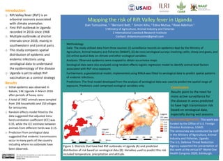
- 1. Methodology Data: The study utilized data from three sources: (i) surveillance records on epidemics kept by the Ministry of Agriculture, Animal Industry and Fisheries (MAAIF), (ii) de novo serological surveys involving cattle, sheep and goats, and (iii) online spatial data on climate and other ecological variables. Analyses: Observed epidemics were mapped to obtain occurrence maps. Serological data were also analyzed using random effects logistic regression model to identify animal-level factors associated with RVF virus exposure. Furthermore, a geostatistical model, implemented using RINLA was fitted to serological data to predict spatial patterns of endemic infections. Predictions: The final model developed from the analysis of serological data was used to predict the spatial range of exposure. Predictors used comprised ecological variables only. Conclusion Results point to the need for more active surveillance for the disease in areas predicted to have high transmission risk based on serological data, especially during wet seasons. Results o Initial epidemic was observed in Kabale, S.W. Uganda in March 2016 after periods of heavy rains. o A total of 3962 animals were sampled from 198 households and 150 villages for serosurvey. o Random effects model fitted to the data suggested that adjusted intra- herd correlation coefficient (ICC) was 0.35, while the ICC estimate between animals from different herds was 0.15. o Prediction from serological data suggested that endemic transmissions occur in many parts of the country including where no outbreaks have been observed. Introduction o Rift Valley fever (RVF) is an arboviral zoonosis associated with climate anomalies o First RVF outbreak in Uganda recorded in 2016 since 1968 o Multiple outbreaks at shorter intervals since 2016; mainly in southwestern and central parts o This study compares spatial distribution of epidemic and endemic infections using serological data to understand the epidemiology of the disease o Uganda is yet to adopt RVF vaccination as a control strategy Figure 1: Districts that have had RVF outbreaks in Uganda (A) and predicted distribution of risk based on serological data (B). Variables used to predict this risk included temperature, precipitation and altitude. Mapping the risk of Rift Valley fever in Uganda Dan Tumusiime, 1, 2 Bernard Bett,2 Simon Kihu, 2 Edna Mutua, 2 Rose Ademun 1 1 Ministry of Agriculture, Animal Industry and Fisheries 2 International Livestock Research Institute Contact: drdantumusiime@gmail.com Acknowledgments: This work was funded by the Office of U.S. Foreign Disaster Assistance, USAID. The serosurvey was conducted by staff in the Ministry of Agriculture, Animal Industry and Fisheries, Uganda. The U.S. Defence Threat Reduction Agency supported the presentation of this work at the virtual 6th World One Health Congress 2020, Edinburgh.This document is licensed for use under the Creative Commons Attribution 4.0 International Licence. October 2020