SlideShare uma empresa Scribd logo
1 de 8
Baixar para ler offline
contact@foodie-project.eu
Issue 8 (October 2016)
FOODIE Newsletter
FOODIE Team'scorner
Nice to see you again!
FOODIE project has just entered in the last 6 months of its lifetime. This issue intends to keep you updated about the
progress in pilot sites and technical activities. Scroll down and find out important dates to be saved in your agenda! Do
not miss the last occasions to meet project partners!
PILOT EXECUTION PROGRESS
Spanish Pilot
After ending the Proof-of-Concept and the Test stages, the Spanish Pilot is facing the Production stage which includes
significant improvements on the FOODIE dashboard. Now it is highly customizable for each agricultural exploitation and
it will count with a new bunch of widgets, pieces of advance visualization software for planning agricultural
interventions and for supporting the decision making processes. Both CTIC and SERESCO have been currently working
on the development of the new widgets and SERESCO has been also implementing the new services required by the
new features of the dashboard.
The most important new features incorporated are:
 Registration and Validation of Management Zones.
 A Visual Interface for Yield Forecasting and
Recommendation of Dates for Harvesting.
 Registration of Treatments and Treatment Plans.
Regarding the on-field
activities in the TERRAS
GAUDA vineyards, the
harvesting has just
finished and, although
the yield is not very high,
there are excellent
prospects in quality. The workers
gather with extreme care the grapes, in order not to damage the product.
We will soon have data about the yield production, which will be used for
validating the grape yield forecasting model based on our machine learning
algorithms.
It will be very interesting for tuning the model and improve next predictions.
Czech pilot
Year 2016 is the last vegetation period of the Czech pilot farm in Trsice covered by FOODIE project. For this reason, the
validation of satellite periodic monitoring and telematics of farm machinery has been started. A main effort of
WIRELESSINFO team in Scenario C is focused on the evaluation of Yield potential zones within the field crops, which
define the field variability from time-series satellite data. The evaluation is based on the comparison with the crop
growth status identified during the vegetation period by Sentinel 2A and Landsat 8 imagery and available yield data
recorded by agronomist. The results of evaluation will be presented in the final period of the project.
Yield potential zones delineated from time-series Landsat data Actual field variability defined by Sentinel 2A NDVI image valid for
25th June 2016
In Telematics of Farm Machinery scenario Wirelessinfo continued with integration of Management Zones (Yield
Potential Zones) and data from machinery monitoring.
As more farms have been added, which consequently resulted in increasing amount of data, it is necessary to focus on
optimizing performance.
German Pilot
35 machine cooperatives worked with WinGIS and more than 100 with mobGIS firstly on laptops and then using tablet-
PCs on machines like harvesters and pickup. After the upgrade they also received training for two new tools that PROGIS
will offer after the project end, in addition to the existing machine cooperatives. Moreover, the model for Precision
Farming has been improved by:
• Upgrading WinGIS as Windows 10 compatible version.
• Launching Mobile GIS app on WinPhone (Windows mobile).
• Open Transport Map (ATM) on OSM (Open Street Map) for a rural road network.
• Sentinell II NDVI + SDK (Software Development Kit) for software-houses.
• Developing a pattern recognition tool “IDIMA” (= IDentification of IMAges) ready by January 2017.
• Gathering first test-results with Phablets (Tablets+smart phones+Windows 10) that will be available in the next
weeks.
Let’s focus on Open Transport Map, Sentinel II and NDVI and IDIMA – IDentification of IMAges description.
Open Transport Map: the basic module has been done during the FOODIE project by WRLS as an upgrade to OSM, linked
to WinGIS and enabled the possibility to setup a rural road map with precise attribute definition. It has to be maintained
by an organization – e.g. Machine Cooperatives - that on a bottom up level also maintains the datasets, e.g. heavy rain
and not to use today, or work on this road until a special date etc. Besides agriculture the same tool will be tested for
further use in forestry.
Sentinel II and NDVI: Further Sentinel 2 tool including NDVI index (worldwide use) is ready for use during November
2016 – February 2017 at all cooperatives interested to take part. They will use WinGIS, BING maps (JRC-certified) and
Sentinel tools including NDVI for a period also after the end of FOODIE project. During the project lifetime PROGIS will
get feedback about usability of the tools
NDVI map of the south of VILLACH/A, July 2016 Orthoimage 25cm + LPIS polygons (either via Ministry or
digitized or GPS-Import)
NDVI Index from 0,4 – 1,0 in one field
New all 5-10 days, mail info if new
IDIMA – IDentification of IMAges: Cooperatives will also get end of the year an IDIMA WinGIS enhancement for pattern
recognition. The three modules are: (1) «RASTER» - carries out the processing and preparation of remote sensing data
for calculations and creation of the classifier; (2) «IDIMA» – creates automatic structure (classification) of digital image
and raster thematic layers of vegetation, with the direct participation of the Adjuster; (3) «VECTOR» - makes the
vectorization of thematic layers and exporting to shape files.
Out of three sensors – R, G, B – (1) a new image is created with better “resolution” for interpretation. Then (2) the
different structures are searched automatically and (3) put into different WinGIS layers and automatically digitized.
Left: the original orthoimages (25cm), digitized with “failures” in hours
Right: an automatically digitized image with precise m² meadow, bushes, stones, rocks, and roads etc., done in 2 seconds.
FOODIE OUTREACH
ISPRS 2016 Conference
12 - 19 July 2016, Prague, Czech Republic
WIRELESSINFO presented the yield potential zones
through a paper entitled “Monitoring of in-field
variability for site specific crop management through
open geospatial information” available on the FOODIE
repository “Download”. WRLS also participated in the
poster session.
MEDHackathon
13 - 15 July 2016, Patras, Greece
This hack event was focused on developing innovative
ideas on top of Open Data and technologies made
available by several projects. This event was also
supported by the CAPSELLA project. Did you miss it?
Here is the session on video. Watch & enjoy!
FOODIE at the 13th ICPA conference
31 July 2016 - 03 August 2016, St. Louis, Missouri, USA
Tomas Reznik from WIRELESSINFO introduced two oral
presentations entitled “Demonstration of FOODIE data
model for precision agriculture” and “Quo Vadis
Precision Farming?” Here the available papers:
https://ispag.org/proceedings/?action=author_abstract
s
FOODIE at the INSPIRE Conference
26 - 30 September 2016, Barcelona, Spain
WIRELESSINFO introduced the presentation VGI profile
for Precision Farming: unified data model and
applications. Volunteered Geographic Information
(VGI) is commonly defined as the harnessing of tools to
create, assemble, and disseminate geo-graphic data
provided voluntarily by individuals.
FOODIE participation in “VGI & Citizens’ Observatories Hackathon” part of the INSPIRE 2016 conference
26 - 27 September 2016, Barcelona, Spain
The VGI and Citizens Observatories INSPIRE Hack was the first hackathon combined with a INSPIRE
conference with the aim to create the space, where those with the interest in the potential of VGI and
Citizens Observatories could meet, present their tools and components from existing projects and discuss
and explore how results, ideas and knowledge could be combined in possible ways for new projects and
for new project ideas. Here the basic details!
http://inspire.ec.europa.eu/events/conferences/inspire_2016/schedule/submissions/365.html
FOODIE at the ISAF 2016
03 - 06 October 2016, Pilsen, Czech Republic
FOODIE representatives demonstrated Farm Telemetry
as a system to support farmers in the management
aspects of farming activities as well as the FOODIE Data
model.
Meeting at the Joint Research Centre (JRC) of the EC,
Ispra Italy
25-26 October 2016, Ispra, Italy
WIRELESSINFO demonstrated INSPIRE achievements
from FOODIE project at the European Commission, DG
Joint Research Centre trough the presentation entitled
“INSPIRE, COPERNICUS AND GEOSS in Precision
Farming: Economical and Ecological Synergies”. All the
details are available at the following link: https://ies-
svn.jrc.ec.europa.eu/projects/mig-inspire/wiki/MIG-
T_meeting_34
FOODIE at the 18th
edition of the International Agricultural Exhibition AGRO SHOW
PSNC disseminated FOODIE project results in the 18th
edition of the International Agricultural Exhibition AGRO SHOW
organized by the Polish Chamber of Commerce for Machinery and Equipment. During this event PSNC imparted a
seminar jointly with the Industrial Institute of Agricultural Engineering (PIMR) and the Wielkopolska Agricultural
Advisory Center (WODR) about savings and improvements in the farm using modern solutions in agriculture, where
results of FOODIE and Agro-IT projects where presented. In particular, the seminar talks included presentations about:
(i) effective management of the farm through AgroIT platform tools, (ii) pest management control with the decision
support system (DSS) of FOODIE Polish pilot, (iii) machinery tracking and monitoring with the farm telemetry
application of FOODIE Czech pilot. Additionally, PSNC had a stand in the exhibition area, where information about
FOODIE project, information about the DSS (co-developed by PSNC and WODR) and the FOODIE marketplace
(developed by PSNC) were provided.
AGRO SHOW for years is seen as the venue for presenting the latest and most modern machines and equipment. It is
also a comprehensive exhibition of the current offer regarding manufacture of fertilizers, seeds, pesticides, financial
firms and other industries related to agriculture. This year, AGRO SHOW statistics include: nearly 830 companies’
exhibitions, including 106 foreign exhibitors from 20 countries (Lithuania, Spain, Great Britain, Turkey, India, and
China); more than 140,000 visitors during the 4 days exhibition; 148 thousand m2 of exhibition space.
Meet members of the FOODIE consortium at the following events:
ISESS 2017, the International
Symposium on Environmental Software
Systems, 10 – 12 May 2017, Zadar,
Croatia
ICC 2017,the International Cartographic
Conference, 2 – 7 July 2017,
Washington, USA
PUBLIC DELIVERABLES
Check the FOODIE repository out which gathers all the project public deliverables. To learn more, please click the
following link: http://www.foodie-project.eu/downloads.php?idc=5
Join FOODIE on Twitter, Facebook, slideshare and LinkedIn and share your comments and opinions with us!
Learn about the project’s goal, its background and its strategy and download the FOODIE Flyer in:
English Spanish German Italian Polish Czech Turkish Latvian Portuguese French Greek
Please disseminate this newsletter amongst your potentially interested colleagues and networks.
This project is partially funded under the ICT Policy Support Programme (ICT PSP) as part of the Competitiveness and Innovation Framework
Programme by the European Commission under grant agreement no. 621074
If you do not want to receive this newsletter from FOODIE project in the future, please unsubscribe writing to contact@foodie-project.eu
Miguel Ángel Esbrí (Συντονιστής του έργου)
Atos Spain, S.A.
C/ Albarracín, 25 - 28037 Madrid (Spain)
Email: miguel.esbri@atos.net
contact@foodie-project.eu
«Το περιεχόμενο του φυλλαδίου αντανακλά
μόνο τις απόψεις του συγγραφέα
και η Ευρωπαϊκή Ένωση δεν είναι υπεύθυνη
για οποιαδήποτε χρήση
της πληροφορίας που περιέχεται σε αυτήν. »
www.foodie-project.eu
www.man.poznan.pl
www.tdf.lv
www.consorziobimpiave.bl.itwww.enco-consulting.it
www.mjm.cz www.progis.com
www.netcad.com
www.wirelessinfo.cz
www.atos.net
www.terrasgauda.com
ΤΟ ΚΊΝΗΤΡΟ
Ο τομέας της γεωργίας αποτελεί στρατηγικά μοναδικό
τομέα που θα πρέπει ιδανικά να αποτελείται από ένα
δίκτυο αλληλοεπιδρώντων οργανισμών. Κατά την εκτέλεση
των γεωργικών δραστηριοτήτων, οι ενδιαφερόμενοι πρέπει
να διαχειρίζονται πολλές διαφορετικές και ετερογενείς
πηγές πληροφοριών, όπως:
• ορισμός πολιτικών,
• αποτίμηση των οικολογικών επιδόσεων,
• ανάπτυξη της γεωργίας, καλλιεργειών, ορισμός του
χρόνου και τιμολόγηση,
• ανίχνευση μάστιγας
Στο πλαίσιο αυτό, το μέλλον των συστήματα διαχείρισης
γνώσης της γεωργίας θα πρέπει όχι μόνο να υποστηρίζει
την άμεση κερδοφορία της ή την προστασία του
περιβάλλοντος, αλλά πρέπει επίσης νασυνδυάσει και να
συντονίσει τις προσπάθειες και τις συμπεριφορές της
βιομηχανίας γεωργικών τροφίμων, τους καταναλωτές,
δημόσιων διοικήσεων και των ευρύτερων ενδιαφερόμενων
κοινοτήτων.
Το έργο αυτό συγχρηματοδοτείται από το πλαίσιο του προγράμματος
στήριξης της πολιτικής για τις ΤΠΕ (ICT PSP), ως μέρος του
προγράμματος πλαισίου ανταγωνιστικότητας και καινοτομίας από
την Ευρωπαϊκή Επιτροπή στο πλαίσιο της συμφωνίας επιχορήγησης
Νο. 621074
ΣΤΟΧΟΙ ΚΑΙΝΟΤΟΜΕΣ ΠΤΥΧΕΣ ΠΕΡΙΓΡΑΦΗ ΤΩΝ ΠΙΛΟΤΙΚΩΝ
Το έργο FOODIE στοχεύει:
• 	 στην δημιουργία μιας ανοικτής και διαλειτουργικής
cloud πλατφόρμας, εξιδεικευμένη στη γεωργία για την
διαχείριση των χωρικών και μη χωρικών
δεδομένων που προέρχονται από ετερογενείς πηγές
•	 ενσωμάτωση των υφιστάμενων ανοιχτών
δεδομένων που σχετίζονται με τη γεωργία, πολύτιμη
πληροφορία για την Ευρώπη
• 	 σύνδεση των δημοσιευμένων δεδομένων
με δεδομένα από εξωτερικές πηγές γεωργίας, μέσω
ηλεκτρονικών εφαρμογών (API)
• 	 παροχή συγκεκριμένων και υψηλής αξίας
εφαρμογών και υπηρεσιών για την υποστήριξη και τον
προγραμματισμό των διαδικασιών και των λήψεων
αποφάσεων, των εμπλεκόμενων ομάδων
• 	 παροχή μια ηλεκτρονικής αγοράς εταιρείες
μπορούν να ανακαλύψουν και να ανταλλάσσουν δεδομένα,
και να δημοσιεύουν τις δικές τους γεωργικές αίτησης με
βάση τα στοιχεία, τις υπηρεσίες και τις εφαρμογές που
παρέχονται από τους το FOODIE.
Το έργο FOODIE παρουσιάζει μια σειρά από καινοτόμες
πτυχές:
• Ανάπτυξη των βασικών και τυποποιημένων υπηρεσιών
σε Cloud εφαρμογές, μειώνοντας όχι μόνο το κόστους
ανάπτυξης αλλά και το κόστος παραγωγής και
συντήρησης
• Εύκολη δυνατότητα εντοπισμού των υπηρεσιών
• Μοντέλο “Pay as you go”
• Μηχανισμοί ανταμοιβής για την ανταλλαγή δεδομένων
• Οικονομικό όφελος για τον τελικό χρήστη
• Πολυ-συσκευή / πολλαπλών χρήσεων.
Το σενάριο του FOODIE και οι στόχοι θα υλοποιηθούν μέσα
από την πλατφόρμα υπηρεσιών, η οποία θα εφαρμοστεί σε
τρεις διαφορετικές πιλοτικές εφαρμογές στην Ευρώπη, τα
οποία θα έχουν ένα σύνολο από κοινές και ειδικές απαιτήσεις:
• 	 Πιλοτικό 1: Ακρίβεια Αμπελουργίας (Ισπανία)
επικεντρώνονται στην κατάλληλη διαχείριση και εγγενή
μεταβλητότητα των καλλιεργειών,
• 	 Πιλοτικό 2: Στρατηγικές και Τακτικές Σχεδιασμού
ανοιχτών δεδομένων (Τσεχία) θα επικεντρωθεί στη βελτίωση
της μελλοντικής διαχείρισης των γεωργικών επιχειρήσεων
(αγροκτήματα) εισάγοντας νέα εργαλεία και μεθόδους
διαχείρισης
• 	 Πιλοτικό 3: Η τεχνολογία επιτρέπει την ενσωμάτωση
των logistics μέσω υπηρεσιών και των γεωργικών
εκμεταλλεύσεων διαχείρισης, συμπεριλαμβανομένης της
ιχνηλασιμότητας(Γερμανία).Τοπιλοτικόαυτόθαεπικεντρωθεί
στην ενσωμάτωση των γερμανικών συνεταιρισμών
μηχανήματων στα υπάρχουσα συστήματα διαχείρισης των
γεωργικών εκμεταλλεύσεων και εφοδιασμού, καθώς και στην
ανάπτυξη και διεύρυνση της υφιστάμενης συνεργασίας και
επιχειρηματικών μοντέλων με διαφορετική αλυσίδα εταίρων.

Mais conteúdo relacionado

Semelhante a FOODIE newsletters issue #8

FOODIE newsletter issue #6
FOODIE newsletter issue #6FOODIE newsletter issue #6
FOODIE newsletter issue #6FOODIE_Project
 
Foodie newsletter issue #2
Foodie newsletter issue #2Foodie newsletter issue #2
Foodie newsletter issue #2FOODIE_Project
 
GI2014 ppt charvat+mayer_the-foodie-project_ dresden
GI2014 ppt charvat+mayer_the-foodie-project_ dresdenGI2014 ppt charvat+mayer_the-foodie-project_ dresden
GI2014 ppt charvat+mayer_the-foodie-project_ dresdenIGN Vorstand
 
Krijn Poppe IoF2020_smart_farming
Krijn Poppe IoF2020_smart_farmingKrijn Poppe IoF2020_smart_farming
Krijn Poppe IoF2020_smart_farmingKrijn Poppe
 
Foodie newsletter issue #1
Foodie newsletter   issue #1Foodie newsletter   issue #1
Foodie newsletter issue #1FOODIE_Project
 
FIWARE MEXICO WorkShop 2016 - 3. FIWARE: Open APIs for Open Cities
FIWARE MEXICO WorkShop 2016 - 3. FIWARE: Open APIs for Open CitiesFIWARE MEXICO WorkShop 2016 - 3. FIWARE: Open APIs for Open Cities
FIWARE MEXICO WorkShop 2016 - 3. FIWARE: Open APIs for Open CitiesFIWARE Mexico
 
AGINFRA+ on EOSCHubWeek
AGINFRA+ on EOSCHubWeekAGINFRA+ on EOSCHubWeek
AGINFRA+ on EOSCHubWeekAGINFRA
 
AGINFRA+ project (Agriculture and food)
AGINFRA+ project (Agriculture and food)AGINFRA+ project (Agriculture and food)
AGINFRA+ project (Agriculture and food)EOSC-hub project
 
05 exploitation platforms in support of agriculture monitoring erwin goor v...
05 exploitation platforms in support of agriculture monitoring   erwin goor v...05 exploitation platforms in support of agriculture monitoring   erwin goor v...
05 exploitation platforms in support of agriculture monitoring erwin goor v...plan4all
 
C. Santoro, Labour Market Areas Web application based on Istat SDP framework
C. Santoro, Labour Market Areas Web application based on Istat SDP frameworkC. Santoro, Labour Market Areas Web application based on Istat SDP framework
C. Santoro, Labour Market Areas Web application based on Istat SDP frameworkIstituto nazionale di statistica
 
An overview of weeding by robots – focus on European solutions
An overview of weeding by robots – focus on European solutionsAn overview of weeding by robots – focus on European solutions
An overview of weeding by robots – focus on European solutionsDavide Rizzo
 
SC4 Workshop 2: Soren Auer BDE project Overview
SC4 Workshop 2: Soren Auer BDE project OverviewSC4 Workshop 2: Soren Auer BDE project Overview
SC4 Workshop 2: Soren Auer BDE project OverviewBigData_Europe
 
CARTIF_CAPRI_sXAIPI_FIWARE_Summit2023_v4.pptx
CARTIF_CAPRI_sXAIPI_FIWARE_Summit2023_v4.pptxCARTIF_CAPRI_sXAIPI_FIWARE_Summit2023_v4.pptx
CARTIF_CAPRI_sXAIPI_FIWARE_Summit2023_v4.pptxFIWARE
 
SC2 Workshop 2: Big Data Europe Project
SC2 Workshop 2: Big Data Europe ProjectSC2 Workshop 2: Big Data Europe Project
SC2 Workshop 2: Big Data Europe ProjectBigData_Europe
 
Can a Smartphone deliver the accuracy for GIS data collection?
Can a Smartphone deliver the accuracy for GIS data collection?Can a Smartphone deliver the accuracy for GIS data collection?
Can a Smartphone deliver the accuracy for GIS data collection?The European GNSS Agency (GSA)
 
SC7 Workshop 3: Space-based applications and Big Data
SC7 Workshop 3: Space-based applications and Big DataSC7 Workshop 3: Space-based applications and Big Data
SC7 Workshop 3: Space-based applications and Big DataBigData_Europe
 
FOODIE Project Expo 2015
FOODIE Project Expo 2015 FOODIE Project Expo 2015
FOODIE Project Expo 2015 FOODIE_Project
 
BDE SC4 Hangout - Simon Scerri, Introduction
BDE SC4 Hangout - Simon Scerri, IntroductionBDE SC4 Hangout - Simon Scerri, Introduction
BDE SC4 Hangout - Simon Scerri, IntroductionBigData_Europe
 
BDE: Concepts, Platform and Pilots
BDE: Concepts, Platform and PilotsBDE: Concepts, Platform and Pilots
BDE: Concepts, Platform and PilotsBigData_Europe
 
Phidias: Steps forward in detection and identification of anomalous atmospher...
Phidias: Steps forward in detection and identification of anomalous atmospher...Phidias: Steps forward in detection and identification of anomalous atmospher...
Phidias: Steps forward in detection and identification of anomalous atmospher...Phidias
 

Semelhante a FOODIE newsletters issue #8 (20)

FOODIE newsletter issue #6
FOODIE newsletter issue #6FOODIE newsletter issue #6
FOODIE newsletter issue #6
 
Foodie newsletter issue #2
Foodie newsletter issue #2Foodie newsletter issue #2
Foodie newsletter issue #2
 
GI2014 ppt charvat+mayer_the-foodie-project_ dresden
GI2014 ppt charvat+mayer_the-foodie-project_ dresdenGI2014 ppt charvat+mayer_the-foodie-project_ dresden
GI2014 ppt charvat+mayer_the-foodie-project_ dresden
 
Krijn Poppe IoF2020_smart_farming
Krijn Poppe IoF2020_smart_farmingKrijn Poppe IoF2020_smart_farming
Krijn Poppe IoF2020_smart_farming
 
Foodie newsletter issue #1
Foodie newsletter   issue #1Foodie newsletter   issue #1
Foodie newsletter issue #1
 
FIWARE MEXICO WorkShop 2016 - 3. FIWARE: Open APIs for Open Cities
FIWARE MEXICO WorkShop 2016 - 3. FIWARE: Open APIs for Open CitiesFIWARE MEXICO WorkShop 2016 - 3. FIWARE: Open APIs for Open Cities
FIWARE MEXICO WorkShop 2016 - 3. FIWARE: Open APIs for Open Cities
 
AGINFRA+ on EOSCHubWeek
AGINFRA+ on EOSCHubWeekAGINFRA+ on EOSCHubWeek
AGINFRA+ on EOSCHubWeek
 
AGINFRA+ project (Agriculture and food)
AGINFRA+ project (Agriculture and food)AGINFRA+ project (Agriculture and food)
AGINFRA+ project (Agriculture and food)
 
05 exploitation platforms in support of agriculture monitoring erwin goor v...
05 exploitation platforms in support of agriculture monitoring   erwin goor v...05 exploitation platforms in support of agriculture monitoring   erwin goor v...
05 exploitation platforms in support of agriculture monitoring erwin goor v...
 
C. Santoro, Labour Market Areas Web application based on Istat SDP framework
C. Santoro, Labour Market Areas Web application based on Istat SDP frameworkC. Santoro, Labour Market Areas Web application based on Istat SDP framework
C. Santoro, Labour Market Areas Web application based on Istat SDP framework
 
An overview of weeding by robots – focus on European solutions
An overview of weeding by robots – focus on European solutionsAn overview of weeding by robots – focus on European solutions
An overview of weeding by robots – focus on European solutions
 
SC4 Workshop 2: Soren Auer BDE project Overview
SC4 Workshop 2: Soren Auer BDE project OverviewSC4 Workshop 2: Soren Auer BDE project Overview
SC4 Workshop 2: Soren Auer BDE project Overview
 
CARTIF_CAPRI_sXAIPI_FIWARE_Summit2023_v4.pptx
CARTIF_CAPRI_sXAIPI_FIWARE_Summit2023_v4.pptxCARTIF_CAPRI_sXAIPI_FIWARE_Summit2023_v4.pptx
CARTIF_CAPRI_sXAIPI_FIWARE_Summit2023_v4.pptx
 
SC2 Workshop 2: Big Data Europe Project
SC2 Workshop 2: Big Data Europe ProjectSC2 Workshop 2: Big Data Europe Project
SC2 Workshop 2: Big Data Europe Project
 
Can a Smartphone deliver the accuracy for GIS data collection?
Can a Smartphone deliver the accuracy for GIS data collection?Can a Smartphone deliver the accuracy for GIS data collection?
Can a Smartphone deliver the accuracy for GIS data collection?
 
SC7 Workshop 3: Space-based applications and Big Data
SC7 Workshop 3: Space-based applications and Big DataSC7 Workshop 3: Space-based applications and Big Data
SC7 Workshop 3: Space-based applications and Big Data
 
FOODIE Project Expo 2015
FOODIE Project Expo 2015 FOODIE Project Expo 2015
FOODIE Project Expo 2015
 
BDE SC4 Hangout - Simon Scerri, Introduction
BDE SC4 Hangout - Simon Scerri, IntroductionBDE SC4 Hangout - Simon Scerri, Introduction
BDE SC4 Hangout - Simon Scerri, Introduction
 
BDE: Concepts, Platform and Pilots
BDE: Concepts, Platform and PilotsBDE: Concepts, Platform and Pilots
BDE: Concepts, Platform and Pilots
 
Phidias: Steps forward in detection and identification of anomalous atmospher...
Phidias: Steps forward in detection and identification of anomalous atmospher...Phidias: Steps forward in detection and identification of anomalous atmospher...
Phidias: Steps forward in detection and identification of anomalous atmospher...
 

Mais de FOODIE_Project

D4.1.1 advanced decision support tools
D4.1.1 advanced decision support toolsD4.1.1 advanced decision support tools
D4.1.1 advanced decision support toolsFOODIE_Project
 
D3.4.2 data fusion tools
D3.4.2 data fusion toolsD3.4.2 data fusion tools
D3.4.2 data fusion toolsFOODIE_Project
 
D3.3.2 sematic tagging and open data publication tools
D3.3.2 sematic tagging and open data publication toolsD3.3.2 sematic tagging and open data publication tools
D3.3.2 sematic tagging and open data publication toolsFOODIE_Project
 
D3.1.2 heterogeneous data repositories and related services
D3.1.2 heterogeneous data repositories and related servicesD3.1.2 heterogeneous data repositories and related services
D3.1.2 heterogeneous data repositories and related servicesFOODIE_Project
 
D5.4.1 Training materials
D5.4.1 Training materialsD5.4.1 Training materials
D5.4.1 Training materialsFOODIE_Project
 
D5.1.1 Pilots description and requirements elicitation report
D5.1.1 Pilots description and requirements elicitation reportD5.1.1 Pilots description and requirements elicitation report
D5.1.1 Pilots description and requirements elicitation reportFOODIE_Project
 
D4.2.1 Advanced rich interfaces
D4.2.1 Advanced rich interfacesD4.2.1 Advanced rich interfaces
D4.2.1 Advanced rich interfacesFOODIE_Project
 
D3.4.1 Data fusion tools
D3.4.1 Data fusion toolsD3.4.1 Data fusion tools
D3.4.1 Data fusion toolsFOODIE_Project
 
D3.3.1 Sematic tagging and open data publication tools
D3.3.1 Sematic tagging and open data publication toolsD3.3.1 Sematic tagging and open data publication tools
D3.3.1 Sematic tagging and open data publication toolsFOODIE_Project
 
D3.2.1 Open and lightweight APIs
D3.2.1 Open and lightweight APIsD3.2.1 Open and lightweight APIs
D3.2.1 Open and lightweight APIsFOODIE_Project
 
D3.1.1 Heterogeneous data repositories and related-services
D3.1.1 Heterogeneous data repositories and related-servicesD3.1.1 Heterogeneous data repositories and related-services
D3.1.1 Heterogeneous data repositories and related-servicesFOODIE_Project
 
D2.1 State of the art analysis report
D2.1 State of the art analysis reportD2.1 State of the art analysis report
D2.1 State of the art analysis reportFOODIE_Project
 
Towards the development of smart agriculture infrastructure in Wielkopolska r...
Towards the development of smart agriculture infrastructure in Wielkopolska r...Towards the development of smart agriculture infrastructure in Wielkopolska r...
Towards the development of smart agriculture infrastructure in Wielkopolska r...FOODIE_Project
 
Open Data as an Opportunity for the Commercial Sector
Open Data as an Opportunity for the Commercial SectorOpen Data as an Opportunity for the Commercial Sector
Open Data as an Opportunity for the Commercial SectorFOODIE_Project
 
Open Data for Local and Regional Development
Open Data for Local and Regional DevelopmentOpen Data for Local and Regional Development
Open Data for Local and Regional DevelopmentFOODIE_Project
 
Foodie flyer Czech version
Foodie flyer Czech versionFoodie flyer Czech version
Foodie flyer Czech versionFOODIE_Project
 

Mais de FOODIE_Project (20)

D4.1.1 advanced decision support tools
D4.1.1 advanced decision support toolsD4.1.1 advanced decision support tools
D4.1.1 advanced decision support tools
 
D3.5.1 marketplace
D3.5.1 marketplaceD3.5.1 marketplace
D3.5.1 marketplace
 
D3.4.2 data fusion tools
D3.4.2 data fusion toolsD3.4.2 data fusion tools
D3.4.2 data fusion tools
 
D3.3.2 sematic tagging and open data publication tools
D3.3.2 sematic tagging and open data publication toolsD3.3.2 sematic tagging and open data publication tools
D3.3.2 sematic tagging and open data publication tools
 
D3.1.2 heterogeneous data repositories and related services
D3.1.2 heterogeneous data repositories and related servicesD3.1.2 heterogeneous data repositories and related services
D3.1.2 heterogeneous data repositories and related services
 
D5.4.1 Training materials
D5.4.1 Training materialsD5.4.1 Training materials
D5.4.1 Training materials
 
D5.1.1 Pilots description and requirements elicitation report
D5.1.1 Pilots description and requirements elicitation reportD5.1.1 Pilots description and requirements elicitation report
D5.1.1 Pilots description and requirements elicitation report
 
D4.2.1 Advanced rich interfaces
D4.2.1 Advanced rich interfacesD4.2.1 Advanced rich interfaces
D4.2.1 Advanced rich interfaces
 
D3.4.1 Data fusion tools
D3.4.1 Data fusion toolsD3.4.1 Data fusion tools
D3.4.1 Data fusion tools
 
D3.3.1 Sematic tagging and open data publication tools
D3.3.1 Sematic tagging and open data publication toolsD3.3.1 Sematic tagging and open data publication tools
D3.3.1 Sematic tagging and open data publication tools
 
D3.2.1 Open and lightweight APIs
D3.2.1 Open and lightweight APIsD3.2.1 Open and lightweight APIs
D3.2.1 Open and lightweight APIs
 
D3.1.1 Heterogeneous data repositories and related-services
D3.1.1 Heterogeneous data repositories and related-servicesD3.1.1 Heterogeneous data repositories and related-services
D3.1.1 Heterogeneous data repositories and related-services
 
D2.1 State of the art analysis report
D2.1 State of the art analysis reportD2.1 State of the art analysis report
D2.1 State of the art analysis report
 
FOODIE Data model
FOODIE Data modelFOODIE Data model
FOODIE Data model
 
Towards the development of smart agriculture infrastructure in Wielkopolska r...
Towards the development of smart agriculture infrastructure in Wielkopolska r...Towards the development of smart agriculture infrastructure in Wielkopolska r...
Towards the development of smart agriculture infrastructure in Wielkopolska r...
 
Open Data as an Opportunity for the Commercial Sector
Open Data as an Opportunity for the Commercial SectorOpen Data as an Opportunity for the Commercial Sector
Open Data as an Opportunity for the Commercial Sector
 
Open Data for Local and Regional Development
Open Data for Local and Regional DevelopmentOpen Data for Local and Regional Development
Open Data for Local and Regional Development
 
Foodie poster
Foodie posterFoodie poster
Foodie poster
 
Foodie poster
Foodie posterFoodie poster
Foodie poster
 
Foodie flyer Czech version
Foodie flyer Czech versionFoodie flyer Czech version
Foodie flyer Czech version
 

Último

Unveiling Design Patterns: A Visual Guide with UML Diagrams
Unveiling Design Patterns: A Visual Guide with UML DiagramsUnveiling Design Patterns: A Visual Guide with UML Diagrams
Unveiling Design Patterns: A Visual Guide with UML DiagramsAhmed Mohamed
 
SensoDat: Simulation-based Sensor Dataset of Self-driving Cars
SensoDat: Simulation-based Sensor Dataset of Self-driving CarsSensoDat: Simulation-based Sensor Dataset of Self-driving Cars
SensoDat: Simulation-based Sensor Dataset of Self-driving CarsChristian Birchler
 
Cloud Data Center Network Construction - IEEE
Cloud Data Center Network Construction - IEEECloud Data Center Network Construction - IEEE
Cloud Data Center Network Construction - IEEEVICTOR MAESTRE RAMIREZ
 
Post Quantum Cryptography – The Impact on Identity
Post Quantum Cryptography – The Impact on IdentityPost Quantum Cryptography – The Impact on Identity
Post Quantum Cryptography – The Impact on Identityteam-WIBU
 
Taming Distributed Systems: Key Insights from Wix's Large-Scale Experience - ...
Taming Distributed Systems: Key Insights from Wix's Large-Scale Experience - ...Taming Distributed Systems: Key Insights from Wix's Large-Scale Experience - ...
Taming Distributed Systems: Key Insights from Wix's Large-Scale Experience - ...Natan Silnitsky
 
Innovate and Collaborate- Harnessing the Power of Open Source Software.pdf
Innovate and Collaborate- Harnessing the Power of Open Source Software.pdfInnovate and Collaborate- Harnessing the Power of Open Source Software.pdf
Innovate and Collaborate- Harnessing the Power of Open Source Software.pdfYashikaSharma391629
 
How to submit a standout Adobe Champion Application
How to submit a standout Adobe Champion ApplicationHow to submit a standout Adobe Champion Application
How to submit a standout Adobe Champion ApplicationBradBedford3
 
Global Identity Enrolment and Verification Pro Solution - Cizo Technology Ser...
Global Identity Enrolment and Verification Pro Solution - Cizo Technology Ser...Global Identity Enrolment and Verification Pro Solution - Cizo Technology Ser...
Global Identity Enrolment and Verification Pro Solution - Cizo Technology Ser...Cizo Technology Services
 
Understanding Flamingo - DeepMind's VLM Architecture
Understanding Flamingo - DeepMind's VLM ArchitectureUnderstanding Flamingo - DeepMind's VLM Architecture
Understanding Flamingo - DeepMind's VLM Architecturerahul_net
 
Large Language Models for Test Case Evolution and Repair
Large Language Models for Test Case Evolution and RepairLarge Language Models for Test Case Evolution and Repair
Large Language Models for Test Case Evolution and RepairLionel Briand
 
Odoo 14 - eLearning Module In Odoo 14 Enterprise
Odoo 14 - eLearning Module In Odoo 14 EnterpriseOdoo 14 - eLearning Module In Odoo 14 Enterprise
Odoo 14 - eLearning Module In Odoo 14 Enterprisepreethippts
 
20240415 [Container Plumbing Days] Usernetes Gen2 - Kubernetes in Rootless Do...
20240415 [Container Plumbing Days] Usernetes Gen2 - Kubernetes in Rootless Do...20240415 [Container Plumbing Days] Usernetes Gen2 - Kubernetes in Rootless Do...
20240415 [Container Plumbing Days] Usernetes Gen2 - Kubernetes in Rootless Do...Akihiro Suda
 
Simplifying Microservices & Apps - The art of effortless development - Meetup...
Simplifying Microservices & Apps - The art of effortless development - Meetup...Simplifying Microservices & Apps - The art of effortless development - Meetup...
Simplifying Microservices & Apps - The art of effortless development - Meetup...Rob Geurden
 
Call Us🔝>༒+91-9711147426⇛Call In girls karol bagh (Delhi)
Call Us🔝>༒+91-9711147426⇛Call In girls karol bagh (Delhi)Call Us🔝>༒+91-9711147426⇛Call In girls karol bagh (Delhi)
Call Us🔝>༒+91-9711147426⇛Call In girls karol bagh (Delhi)jennyeacort
 
UI5ers live - Custom Controls wrapping 3rd-party libs.pptx
UI5ers live - Custom Controls wrapping 3rd-party libs.pptxUI5ers live - Custom Controls wrapping 3rd-party libs.pptx
UI5ers live - Custom Controls wrapping 3rd-party libs.pptxAndreas Kunz
 
SuccessFactors 1H 2024 Release - Sneak-Peek by Deloitte Germany
SuccessFactors 1H 2024 Release - Sneak-Peek by Deloitte GermanySuccessFactors 1H 2024 Release - Sneak-Peek by Deloitte Germany
SuccessFactors 1H 2024 Release - Sneak-Peek by Deloitte GermanyChristoph Pohl
 
Comparing Linux OS Image Update Models - EOSS 2024.pdf
Comparing Linux OS Image Update Models - EOSS 2024.pdfComparing Linux OS Image Update Models - EOSS 2024.pdf
Comparing Linux OS Image Update Models - EOSS 2024.pdfDrew Moseley
 
Salesforce Implementation Services PPT By ABSYZ
Salesforce Implementation Services PPT By ABSYZSalesforce Implementation Services PPT By ABSYZ
Salesforce Implementation Services PPT By ABSYZABSYZ Inc
 
Cyber security and its impact on E commerce
Cyber security and its impact on E commerceCyber security and its impact on E commerce
Cyber security and its impact on E commercemanigoyal112
 
GOING AOT WITH GRAALVM – DEVOXX GREECE.pdf
GOING AOT WITH GRAALVM – DEVOXX GREECE.pdfGOING AOT WITH GRAALVM – DEVOXX GREECE.pdf
GOING AOT WITH GRAALVM – DEVOXX GREECE.pdfAlina Yurenko
 

Último (20)

Unveiling Design Patterns: A Visual Guide with UML Diagrams
Unveiling Design Patterns: A Visual Guide with UML DiagramsUnveiling Design Patterns: A Visual Guide with UML Diagrams
Unveiling Design Patterns: A Visual Guide with UML Diagrams
 
SensoDat: Simulation-based Sensor Dataset of Self-driving Cars
SensoDat: Simulation-based Sensor Dataset of Self-driving CarsSensoDat: Simulation-based Sensor Dataset of Self-driving Cars
SensoDat: Simulation-based Sensor Dataset of Self-driving Cars
 
Cloud Data Center Network Construction - IEEE
Cloud Data Center Network Construction - IEEECloud Data Center Network Construction - IEEE
Cloud Data Center Network Construction - IEEE
 
Post Quantum Cryptography – The Impact on Identity
Post Quantum Cryptography – The Impact on IdentityPost Quantum Cryptography – The Impact on Identity
Post Quantum Cryptography – The Impact on Identity
 
Taming Distributed Systems: Key Insights from Wix's Large-Scale Experience - ...
Taming Distributed Systems: Key Insights from Wix's Large-Scale Experience - ...Taming Distributed Systems: Key Insights from Wix's Large-Scale Experience - ...
Taming Distributed Systems: Key Insights from Wix's Large-Scale Experience - ...
 
Innovate and Collaborate- Harnessing the Power of Open Source Software.pdf
Innovate and Collaborate- Harnessing the Power of Open Source Software.pdfInnovate and Collaborate- Harnessing the Power of Open Source Software.pdf
Innovate and Collaborate- Harnessing the Power of Open Source Software.pdf
 
How to submit a standout Adobe Champion Application
How to submit a standout Adobe Champion ApplicationHow to submit a standout Adobe Champion Application
How to submit a standout Adobe Champion Application
 
Global Identity Enrolment and Verification Pro Solution - Cizo Technology Ser...
Global Identity Enrolment and Verification Pro Solution - Cizo Technology Ser...Global Identity Enrolment and Verification Pro Solution - Cizo Technology Ser...
Global Identity Enrolment and Verification Pro Solution - Cizo Technology Ser...
 
Understanding Flamingo - DeepMind's VLM Architecture
Understanding Flamingo - DeepMind's VLM ArchitectureUnderstanding Flamingo - DeepMind's VLM Architecture
Understanding Flamingo - DeepMind's VLM Architecture
 
Large Language Models for Test Case Evolution and Repair
Large Language Models for Test Case Evolution and RepairLarge Language Models for Test Case Evolution and Repair
Large Language Models for Test Case Evolution and Repair
 
Odoo 14 - eLearning Module In Odoo 14 Enterprise
Odoo 14 - eLearning Module In Odoo 14 EnterpriseOdoo 14 - eLearning Module In Odoo 14 Enterprise
Odoo 14 - eLearning Module In Odoo 14 Enterprise
 
20240415 [Container Plumbing Days] Usernetes Gen2 - Kubernetes in Rootless Do...
20240415 [Container Plumbing Days] Usernetes Gen2 - Kubernetes in Rootless Do...20240415 [Container Plumbing Days] Usernetes Gen2 - Kubernetes in Rootless Do...
20240415 [Container Plumbing Days] Usernetes Gen2 - Kubernetes in Rootless Do...
 
Simplifying Microservices & Apps - The art of effortless development - Meetup...
Simplifying Microservices & Apps - The art of effortless development - Meetup...Simplifying Microservices & Apps - The art of effortless development - Meetup...
Simplifying Microservices & Apps - The art of effortless development - Meetup...
 
Call Us🔝>༒+91-9711147426⇛Call In girls karol bagh (Delhi)
Call Us🔝>༒+91-9711147426⇛Call In girls karol bagh (Delhi)Call Us🔝>༒+91-9711147426⇛Call In girls karol bagh (Delhi)
Call Us🔝>༒+91-9711147426⇛Call In girls karol bagh (Delhi)
 
UI5ers live - Custom Controls wrapping 3rd-party libs.pptx
UI5ers live - Custom Controls wrapping 3rd-party libs.pptxUI5ers live - Custom Controls wrapping 3rd-party libs.pptx
UI5ers live - Custom Controls wrapping 3rd-party libs.pptx
 
SuccessFactors 1H 2024 Release - Sneak-Peek by Deloitte Germany
SuccessFactors 1H 2024 Release - Sneak-Peek by Deloitte GermanySuccessFactors 1H 2024 Release - Sneak-Peek by Deloitte Germany
SuccessFactors 1H 2024 Release - Sneak-Peek by Deloitte Germany
 
Comparing Linux OS Image Update Models - EOSS 2024.pdf
Comparing Linux OS Image Update Models - EOSS 2024.pdfComparing Linux OS Image Update Models - EOSS 2024.pdf
Comparing Linux OS Image Update Models - EOSS 2024.pdf
 
Salesforce Implementation Services PPT By ABSYZ
Salesforce Implementation Services PPT By ABSYZSalesforce Implementation Services PPT By ABSYZ
Salesforce Implementation Services PPT By ABSYZ
 
Cyber security and its impact on E commerce
Cyber security and its impact on E commerceCyber security and its impact on E commerce
Cyber security and its impact on E commerce
 
GOING AOT WITH GRAALVM – DEVOXX GREECE.pdf
GOING AOT WITH GRAALVM – DEVOXX GREECE.pdfGOING AOT WITH GRAALVM – DEVOXX GREECE.pdf
GOING AOT WITH GRAALVM – DEVOXX GREECE.pdf
 

FOODIE newsletters issue #8

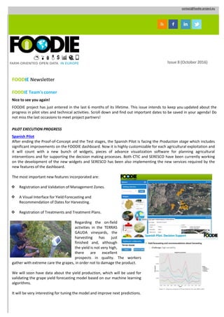
  • 1. contact@foodie-project.eu Issue 8 (October 2016) FOODIE Newsletter FOODIE Team'scorner Nice to see you again! FOODIE project has just entered in the last 6 months of its lifetime. This issue intends to keep you updated about the progress in pilot sites and technical activities. Scroll down and find out important dates to be saved in your agenda! Do not miss the last occasions to meet project partners! PILOT EXECUTION PROGRESS Spanish Pilot After ending the Proof-of-Concept and the Test stages, the Spanish Pilot is facing the Production stage which includes significant improvements on the FOODIE dashboard. Now it is highly customizable for each agricultural exploitation and it will count with a new bunch of widgets, pieces of advance visualization software for planning agricultural interventions and for supporting the decision making processes. Both CTIC and SERESCO have been currently working on the development of the new widgets and SERESCO has been also implementing the new services required by the new features of the dashboard. The most important new features incorporated are:  Registration and Validation of Management Zones.  A Visual Interface for Yield Forecasting and Recommendation of Dates for Harvesting.  Registration of Treatments and Treatment Plans. Regarding the on-field activities in the TERRAS GAUDA vineyards, the harvesting has just finished and, although the yield is not very high, there are excellent prospects in quality. The workers gather with extreme care the grapes, in order not to damage the product. We will soon have data about the yield production, which will be used for validating the grape yield forecasting model based on our machine learning algorithms. It will be very interesting for tuning the model and improve next predictions.
  • 2. Czech pilot Year 2016 is the last vegetation period of the Czech pilot farm in Trsice covered by FOODIE project. For this reason, the validation of satellite periodic monitoring and telematics of farm machinery has been started. A main effort of WIRELESSINFO team in Scenario C is focused on the evaluation of Yield potential zones within the field crops, which define the field variability from time-series satellite data. The evaluation is based on the comparison with the crop growth status identified during the vegetation period by Sentinel 2A and Landsat 8 imagery and available yield data recorded by agronomist. The results of evaluation will be presented in the final period of the project. Yield potential zones delineated from time-series Landsat data Actual field variability defined by Sentinel 2A NDVI image valid for 25th June 2016 In Telematics of Farm Machinery scenario Wirelessinfo continued with integration of Management Zones (Yield Potential Zones) and data from machinery monitoring. As more farms have been added, which consequently resulted in increasing amount of data, it is necessary to focus on optimizing performance. German Pilot 35 machine cooperatives worked with WinGIS and more than 100 with mobGIS firstly on laptops and then using tablet- PCs on machines like harvesters and pickup. After the upgrade they also received training for two new tools that PROGIS will offer after the project end, in addition to the existing machine cooperatives. Moreover, the model for Precision Farming has been improved by: • Upgrading WinGIS as Windows 10 compatible version. • Launching Mobile GIS app on WinPhone (Windows mobile). • Open Transport Map (ATM) on OSM (Open Street Map) for a rural road network. • Sentinell II NDVI + SDK (Software Development Kit) for software-houses. • Developing a pattern recognition tool “IDIMA” (= IDentification of IMAges) ready by January 2017. • Gathering first test-results with Phablets (Tablets+smart phones+Windows 10) that will be available in the next weeks. Let’s focus on Open Transport Map, Sentinel II and NDVI and IDIMA – IDentification of IMAges description. Open Transport Map: the basic module has been done during the FOODIE project by WRLS as an upgrade to OSM, linked to WinGIS and enabled the possibility to setup a rural road map with precise attribute definition. It has to be maintained by an organization – e.g. Machine Cooperatives - that on a bottom up level also maintains the datasets, e.g. heavy rain and not to use today, or work on this road until a special date etc. Besides agriculture the same tool will be tested for further use in forestry. Sentinel II and NDVI: Further Sentinel 2 tool including NDVI index (worldwide use) is ready for use during November 2016 – February 2017 at all cooperatives interested to take part. They will use WinGIS, BING maps (JRC-certified) and Sentinel tools including NDVI for a period also after the end of FOODIE project. During the project lifetime PROGIS will get feedback about usability of the tools
  • 3. NDVI map of the south of VILLACH/A, July 2016 Orthoimage 25cm + LPIS polygons (either via Ministry or digitized or GPS-Import) NDVI Index from 0,4 – 1,0 in one field New all 5-10 days, mail info if new IDIMA – IDentification of IMAges: Cooperatives will also get end of the year an IDIMA WinGIS enhancement for pattern recognition. The three modules are: (1) «RASTER» - carries out the processing and preparation of remote sensing data for calculations and creation of the classifier; (2) «IDIMA» – creates automatic structure (classification) of digital image and raster thematic layers of vegetation, with the direct participation of the Adjuster; (3) «VECTOR» - makes the vectorization of thematic layers and exporting to shape files. Out of three sensors – R, G, B – (1) a new image is created with better “resolution” for interpretation. Then (2) the different structures are searched automatically and (3) put into different WinGIS layers and automatically digitized. Left: the original orthoimages (25cm), digitized with “failures” in hours Right: an automatically digitized image with precise m² meadow, bushes, stones, rocks, and roads etc., done in 2 seconds.
  • 4. FOODIE OUTREACH ISPRS 2016 Conference 12 - 19 July 2016, Prague, Czech Republic WIRELESSINFO presented the yield potential zones through a paper entitled “Monitoring of in-field variability for site specific crop management through open geospatial information” available on the FOODIE repository “Download”. WRLS also participated in the poster session. MEDHackathon 13 - 15 July 2016, Patras, Greece This hack event was focused on developing innovative ideas on top of Open Data and technologies made available by several projects. This event was also supported by the CAPSELLA project. Did you miss it? Here is the session on video. Watch & enjoy! FOODIE at the 13th ICPA conference 31 July 2016 - 03 August 2016, St. Louis, Missouri, USA Tomas Reznik from WIRELESSINFO introduced two oral presentations entitled “Demonstration of FOODIE data model for precision agriculture” and “Quo Vadis Precision Farming?” Here the available papers: https://ispag.org/proceedings/?action=author_abstract s FOODIE at the INSPIRE Conference 26 - 30 September 2016, Barcelona, Spain WIRELESSINFO introduced the presentation VGI profile for Precision Farming: unified data model and applications. Volunteered Geographic Information (VGI) is commonly defined as the harnessing of tools to create, assemble, and disseminate geo-graphic data provided voluntarily by individuals. FOODIE participation in “VGI & Citizens’ Observatories Hackathon” part of the INSPIRE 2016 conference 26 - 27 September 2016, Barcelona, Spain The VGI and Citizens Observatories INSPIRE Hack was the first hackathon combined with a INSPIRE conference with the aim to create the space, where those with the interest in the potential of VGI and Citizens Observatories could meet, present their tools and components from existing projects and discuss and explore how results, ideas and knowledge could be combined in possible ways for new projects and for new project ideas. Here the basic details! http://inspire.ec.europa.eu/events/conferences/inspire_2016/schedule/submissions/365.html
  • 5. FOODIE at the ISAF 2016 03 - 06 October 2016, Pilsen, Czech Republic FOODIE representatives demonstrated Farm Telemetry as a system to support farmers in the management aspects of farming activities as well as the FOODIE Data model. Meeting at the Joint Research Centre (JRC) of the EC, Ispra Italy 25-26 October 2016, Ispra, Italy WIRELESSINFO demonstrated INSPIRE achievements from FOODIE project at the European Commission, DG Joint Research Centre trough the presentation entitled “INSPIRE, COPERNICUS AND GEOSS in Precision Farming: Economical and Ecological Synergies”. All the details are available at the following link: https://ies- svn.jrc.ec.europa.eu/projects/mig-inspire/wiki/MIG- T_meeting_34 FOODIE at the 18th edition of the International Agricultural Exhibition AGRO SHOW PSNC disseminated FOODIE project results in the 18th edition of the International Agricultural Exhibition AGRO SHOW organized by the Polish Chamber of Commerce for Machinery and Equipment. During this event PSNC imparted a seminar jointly with the Industrial Institute of Agricultural Engineering (PIMR) and the Wielkopolska Agricultural Advisory Center (WODR) about savings and improvements in the farm using modern solutions in agriculture, where results of FOODIE and Agro-IT projects where presented. In particular, the seminar talks included presentations about: (i) effective management of the farm through AgroIT platform tools, (ii) pest management control with the decision support system (DSS) of FOODIE Polish pilot, (iii) machinery tracking and monitoring with the farm telemetry application of FOODIE Czech pilot. Additionally, PSNC had a stand in the exhibition area, where information about FOODIE project, information about the DSS (co-developed by PSNC and WODR) and the FOODIE marketplace (developed by PSNC) were provided. AGRO SHOW for years is seen as the venue for presenting the latest and most modern machines and equipment. It is also a comprehensive exhibition of the current offer regarding manufacture of fertilizers, seeds, pesticides, financial firms and other industries related to agriculture. This year, AGRO SHOW statistics include: nearly 830 companies’ exhibitions, including 106 foreign exhibitors from 20 countries (Lithuania, Spain, Great Britain, Turkey, India, and China); more than 140,000 visitors during the 4 days exhibition; 148 thousand m2 of exhibition space. Meet members of the FOODIE consortium at the following events: ISESS 2017, the International Symposium on Environmental Software Systems, 10 – 12 May 2017, Zadar, Croatia ICC 2017,the International Cartographic Conference, 2 – 7 July 2017, Washington, USA
  • 6. PUBLIC DELIVERABLES Check the FOODIE repository out which gathers all the project public deliverables. To learn more, please click the following link: http://www.foodie-project.eu/downloads.php?idc=5 Join FOODIE on Twitter, Facebook, slideshare and LinkedIn and share your comments and opinions with us! Learn about the project’s goal, its background and its strategy and download the FOODIE Flyer in: English Spanish German Italian Polish Czech Turkish Latvian Portuguese French Greek Please disseminate this newsletter amongst your potentially interested colleagues and networks. This project is partially funded under the ICT Policy Support Programme (ICT PSP) as part of the Competitiveness and Innovation Framework Programme by the European Commission under grant agreement no. 621074 If you do not want to receive this newsletter from FOODIE project in the future, please unsubscribe writing to contact@foodie-project.eu
  • 7. Miguel Ángel Esbrí (Συντονιστής του έργου) Atos Spain, S.A. C/ Albarracín, 25 - 28037 Madrid (Spain) Email: miguel.esbri@atos.net contact@foodie-project.eu «Το περιεχόμενο του φυλλαδίου αντανακλά μόνο τις απόψεις του συγγραφέα και η Ευρωπαϊκή Ένωση δεν είναι υπεύθυνη για οποιαδήποτε χρήση της πληροφορίας που περιέχεται σε αυτήν. » www.foodie-project.eu www.man.poznan.pl www.tdf.lv www.consorziobimpiave.bl.itwww.enco-consulting.it www.mjm.cz www.progis.com www.netcad.com www.wirelessinfo.cz www.atos.net www.terrasgauda.com ΤΟ ΚΊΝΗΤΡΟ Ο τομέας της γεωργίας αποτελεί στρατηγικά μοναδικό τομέα που θα πρέπει ιδανικά να αποτελείται από ένα δίκτυο αλληλοεπιδρώντων οργανισμών. Κατά την εκτέλεση των γεωργικών δραστηριοτήτων, οι ενδιαφερόμενοι πρέπει να διαχειρίζονται πολλές διαφορετικές και ετερογενείς πηγές πληροφοριών, όπως: • ορισμός πολιτικών, • αποτίμηση των οικολογικών επιδόσεων, • ανάπτυξη της γεωργίας, καλλιεργειών, ορισμός του χρόνου και τιμολόγηση, • ανίχνευση μάστιγας Στο πλαίσιο αυτό, το μέλλον των συστήματα διαχείρισης γνώσης της γεωργίας θα πρέπει όχι μόνο να υποστηρίζει την άμεση κερδοφορία της ή την προστασία του περιβάλλοντος, αλλά πρέπει επίσης νασυνδυάσει και να συντονίσει τις προσπάθειες και τις συμπεριφορές της βιομηχανίας γεωργικών τροφίμων, τους καταναλωτές, δημόσιων διοικήσεων και των ευρύτερων ενδιαφερόμενων κοινοτήτων. Το έργο αυτό συγχρηματοδοτείται από το πλαίσιο του προγράμματος στήριξης της πολιτικής για τις ΤΠΕ (ICT PSP), ως μέρος του προγράμματος πλαισίου ανταγωνιστικότητας και καινοτομίας από την Ευρωπαϊκή Επιτροπή στο πλαίσιο της συμφωνίας επιχορήγησης Νο. 621074
  • 8. ΣΤΟΧΟΙ ΚΑΙΝΟΤΟΜΕΣ ΠΤΥΧΕΣ ΠΕΡΙΓΡΑΦΗ ΤΩΝ ΠΙΛΟΤΙΚΩΝ Το έργο FOODIE στοχεύει: • στην δημιουργία μιας ανοικτής και διαλειτουργικής cloud πλατφόρμας, εξιδεικευμένη στη γεωργία για την διαχείριση των χωρικών και μη χωρικών δεδομένων που προέρχονται από ετερογενείς πηγές • ενσωμάτωση των υφιστάμενων ανοιχτών δεδομένων που σχετίζονται με τη γεωργία, πολύτιμη πληροφορία για την Ευρώπη • σύνδεση των δημοσιευμένων δεδομένων με δεδομένα από εξωτερικές πηγές γεωργίας, μέσω ηλεκτρονικών εφαρμογών (API) • παροχή συγκεκριμένων και υψηλής αξίας εφαρμογών και υπηρεσιών για την υποστήριξη και τον προγραμματισμό των διαδικασιών και των λήψεων αποφάσεων, των εμπλεκόμενων ομάδων • παροχή μια ηλεκτρονικής αγοράς εταιρείες μπορούν να ανακαλύψουν και να ανταλλάσσουν δεδομένα, και να δημοσιεύουν τις δικές τους γεωργικές αίτησης με βάση τα στοιχεία, τις υπηρεσίες και τις εφαρμογές που παρέχονται από τους το FOODIE. Το έργο FOODIE παρουσιάζει μια σειρά από καινοτόμες πτυχές: • Ανάπτυξη των βασικών και τυποποιημένων υπηρεσιών σε Cloud εφαρμογές, μειώνοντας όχι μόνο το κόστους ανάπτυξης αλλά και το κόστος παραγωγής και συντήρησης • Εύκολη δυνατότητα εντοπισμού των υπηρεσιών • Μοντέλο “Pay as you go” • Μηχανισμοί ανταμοιβής για την ανταλλαγή δεδομένων • Οικονομικό όφελος για τον τελικό χρήστη • Πολυ-συσκευή / πολλαπλών χρήσεων. Το σενάριο του FOODIE και οι στόχοι θα υλοποιηθούν μέσα από την πλατφόρμα υπηρεσιών, η οποία θα εφαρμοστεί σε τρεις διαφορετικές πιλοτικές εφαρμογές στην Ευρώπη, τα οποία θα έχουν ένα σύνολο από κοινές και ειδικές απαιτήσεις: • Πιλοτικό 1: Ακρίβεια Αμπελουργίας (Ισπανία) επικεντρώνονται στην κατάλληλη διαχείριση και εγγενή μεταβλητότητα των καλλιεργειών, • Πιλοτικό 2: Στρατηγικές και Τακτικές Σχεδιασμού ανοιχτών δεδομένων (Τσεχία) θα επικεντρωθεί στη βελτίωση της μελλοντικής διαχείρισης των γεωργικών επιχειρήσεων (αγροκτήματα) εισάγοντας νέα εργαλεία και μεθόδους διαχείρισης • Πιλοτικό 3: Η τεχνολογία επιτρέπει την ενσωμάτωση των logistics μέσω υπηρεσιών και των γεωργικών εκμεταλλεύσεων διαχείρισης, συμπεριλαμβανομένης της ιχνηλασιμότητας(Γερμανία).Τοπιλοτικόαυτόθαεπικεντρωθεί στην ενσωμάτωση των γερμανικών συνεταιρισμών μηχανήματων στα υπάρχουσα συστήματα διαχείρισης των γεωργικών εκμεταλλεύσεων και εφοδιασμού, καθώς και στην ανάπτυξη και διεύρυνση της υφιστάμενης συνεργασίας και επιχειρηματικών μοντέλων με διαφορετική αλυσίδα εταίρων.