SlideShare a Scribd company logo
1 of 21
1 | P a g e
When disaster strikes
2001 GUJARAT EARTHQU AKE: WHEN INDIA FACED ONE OF
ITS WORST DISASTERS 16 YEARS AGO
DEMYSTIFYING A HIMALAYAN TRAGEDY: STUDY OF 2013
UTTARAKHAND DISASTER
BY: EMAAN SHARMA
2 | P a g e
BTCE 802 DISASTER MANAGEMENT
D E F I N I T I O N
This is defined as any catastrophic situation in which usual patterns of life or ecosystems are
disturbed, and extraordinary emergency measures become necessary to save and preserve human life
or the environment.
“A serious disruption of the functioning of a community or a society involving widespread human,
material, economic or environmental losses and impacts, which exceeds the ability of the affected
community or society to cope using its own resources.”
K E Y F A C T O R S
A disaster may have the following main features:-
 Unpredictability,
 Unfamiliarity,
 Speed,
 Urgency,
 Uncertainty and
 Threat
Vulnerability, Hazards and Risk are the main key points when ever disaster mitigation and
management is considered.
H A Z A R D A N D D I S A S T E R
Hazard and disaster are closely related terms. However, to be more precise, a hazard is a natural
condition while the disaster is its consequence.
Hazard refers to the situation which may cause disaster. They could be either man-made or naturally
occurring hazards in our environment. Hazards have been categorised as fast & slow impacting, and
as natural or man-made.
D I S A S T E R T Y P E S
CLASSIFICATIONS BASED ON CAUSE
 Natural hazards
 Man-made hazards
CLASSIFICATIONS BASED ON SPEED
 Sudden onset hazards
 Slow onset hazards
3 | P a g e
C H A R A C T E R I Z A T I O N O F H A Z A R D S
1) Water and climate related hazards
Floods, Droughts, Cyclones, Tornadoes & Hurricanes, Hailstorms, Cloud burst, Snow
avalanches, Heat & cold waves, Sea erosion, Thunder & lightening.
2) Geologically related hazards
Earthquakes, Mud flows, Dam failures, Landslides, Dam bursts.
3) Chemical, Industrial & Nuclear related hazards
Chemical and Industrial disasters, Industrial pollution, Nuclear disasters.
4) Accident related disasters
Road, Rail & other transportation accidents, Major building collapse, Serial Bomb blasts,
Fires, Forest fires.
5) Biologically related hazards
Biological disasters, Epidemics, Cattle epidemics, Pest attacks, Food poisoning.
D I S A S T E R F A C T O R S
Disasters result from a combination of hazards, vulnerable conditions and insufficient capacity or
insufficient measures to reduce the potential negative consequences of risk.
V U L E R A B I L I T Y
Vulnerability refers to a situation of physical, social, economic and environmental factors or
processes that increase the susceptibility of a community from the impact of a hazard.
C A P A C I T Y
Capacity is the combination of all forces and resources that are available within the community,
society or organization which can reduce the level of risk or the consequences of the disaster. This
includes physical, institutional, social or economic means as well as skilled employees or common
characteristics such as leadership and management. Endurance can also be described as capability.
R I S K
Risk is the probability of harmful consequences or expected losses (death, injuries, property,
livelihoods, economic activity disturbances or environmental damage) resulting from the interaction
between natural or man-made hazards and vulnerable conditions.
The load capacity is identified as an element which can reduce the consequences of hazards and
vulnerabilities at a dramatic rate so that the risk is minimized.
For example, a hazard caused by an intense earthquake would vary in degrees of destruction of human
life, property and economic activity in a sparsely populated village compared to a densely populated
city.
RISK = VULNERABILITY * HAZARD
4 | P a g e
H A Z A R D V U L N E R A B I L I T Y I N I N D I A
The land of India comprises of four regions, namely, the Great Mountain zone, Plains of the Ganges
and the Brahmaputra; the Desert region and the Southern Peninsula. Due to the vast diversity in its
geographical features, India is a major disaster prone area in the Asia-Pacific region. 85% of the land
area is vulnerable to one disaster or the other.
During 1991 census of India, risk to existing housing stock in various states and UT’s has been
estimated by an expert group set up by the ministry of Urban Affairs and Employment. According to
the committee, about 39 lacs houses are susceptible to earthquakes of very high intensity, about 2
crore houses are susceptible to winds and about 93 lakh houses are susceptible to floods. Some 49%
of the total housing stock is vulnerable from high to very high damage caused from one or the other
natural hazard; while about 1% of total housing stock gets destroyed every year. In earthquakes, 80%
deaths are caused when a building collapses. Still, non-engineered buildings continue to be built in the
areas prone to natural disasters. As per estimates, the number of people effected by disasters has been
increasing by 6% every year since 1960.
D I S A S T E R M A N A G E M E N T
Disaster management has a multidisciplinary and pro-active approach. Disaster management involves
a spectrum of activities designed to maintain control over disaster and emergency situations and to
provide a framework for helping persons at risk to avoid the impact of disaster. Disaster situations can
be easily divided into three distinct phases with regard to time.
1) PRE- DISASTER PHASE
It encompasses all the actions taken prior to the occurrence of any disaster. For example-
construction of buildings which can withstand the impact of disaster. It is also called
‘Mitigation phase’.
2) DURING- DISASTER PHASE
During this phase, timely warning is to be given to the people so that they can timely take
action to face the disaster. It is also called ‘Preparatory phase’.
3) POST – DISASTER PHASE
It includes the measures that are taken after the occurrence of a disaster. It further includes
three phases-
a) RELIEF PHASE
b) REHABILITATION PHASE
c) RECONSTRUCTION PHASE
D I S A S T E R M A N A G E M E N T P R O C E S S
DISASTER MITIGATION AND PREVENTION
 Multi-hazard risk assessment and mapping
 Manage the hazards, vulnerabilities and risks
 Enforce DRR-related laws/ orders/ regulations such as
building and structural codes, fire codes, mining laws,
etc.
5 | P a g e
DISASTER PREPAREDNESS
 Capacity building through training orientation, drills and exercises
 Establish and operate an end-to-end early warning system;
 Conduct of IEC/ Advocacy campaign
 Maintain a database of DRRM resources, location of critical infrastructures and their
capacities such as hospitals and evacuation centers
 Organize, train, equip and supervise local emergency response teams and accredited
community volunteers
 Promote and raise public awareness
DISASTER RESPONSE
 Continuous disaster monitoring and mobilizing instrument abilities and entities of the LGUs,
CSOs, private groups and organized volunteers for response
 Respond to and manage the adverse impacts of emergencies;
 Provision of emergency relief (food and non-food items, shelter, medical supplies, evacuation
camp management)
 Declaration of state of calamity; suspension of classes and work
 Conduct of rapid damage needs assessment and incident command system
DISASTER REHABILITATION
AND RECOVERY
 Food and cash-for-work
program
 Permanent housing
 Livelihood
 Healthcare and wellness
programs
6 | P a g e
R I S K M A P P I N G
• Mapping the community or area of risk
• Includes schools, hospitals, churches, fire stations, police stations, municipal
buildings
• Shows hazardous buildings
• Uses distinctive symbols
• May include significant infrastructure and disaster prone features
V U L N E R A B I L I T Y A N A L Y S I S
A process which results in an understanding of the types and levels of exposures of persons,
property and the environment to the effects of identified hazard at a particular time.
VULNERABILITY = PEOPLE + CONDITION + PLACE + TIME + EVENT
The process to identify physical, social and economic conditions susceptible to the effects of
hazard of a given intensity by focusing on the types of risks to which they are exposed.
R O L E O F N G O S I N D I S A S T E R M I T I G A T I O N A N D
M A N A G E M E N T
 Crucial, Essential and Vital
 To Reduce Communication gap
 In present scenario – Strengthening Disaster Preparedness and Mitigation.
 In Preparedness: To mobilize, organize training, linking, assessment, monitoring,
process and share data during and after disaster.
 In Mitigation: Awareness-strengthening disaster preparedness measures-Improving
Infrastructure-water and sanitation systems
7 | P a g e
EARTHQUAKES
Earthquakes are a naturally destructive effect of our earth's constantly changing surface, and
thousands of them happen every day.
Earthquakes, also called temblors, can be so tremendously destructive; it’s hard to imagine they
occur by the thousands every day around the world, usually in the form of small tremors.
Earthquakes are unpredictable and can strike with enough force to bring buildings down.
It is a geological disaster that occurs without warning and involves violent shaking of the ground and
everything over it. Earthquakes can range in size from those that are so weak that they cannot be felt
to those violent enough to toss people around and destroy whole cities. In its most general sense, the
word earthquake is used to describe any seismic event — whether natural or caused by humans —
that generates seismic waves.
W H E R E D O M O S T E A R T H Q U A K E S O C C U R ?
Some 80 percent of all the planet's earthquakes occur along the rim of the Pacific Ocean, called the
"Ring of Fire" because of the preponderance of volcanic activity there as well. Most earthquakes
occur at fault zones, where tectonic plates—giant rock slabs that make up the Earth's upper layer—
collide or slide against each other. These impacts are usually gradual and unnoticeable on the
surface; however, immense stress can build up between plates. When this stress is released quickly,
it sends massive vibrations, called seismic waves, often hundreds of miles through the rock and up
to the surface. Other quakes can occur far from faults zones when plates are stretched or squeezed.
E A R T H Q U A K E M A G N I T U D E R A T I N G S A N D T H E I R I M P A C T S
It's important to be able to distinguish between minor earthquakes that cause no damage or fatalities
and major earthquakes that result in horrific loss of life. That's why we usually describe earthquakes
by giving them a number on either the Richter scale or the Mercalli scale. A quake measuring 3 to 5
is considered minor or light; 5 to 7 is moderate to strong; 7 to 8 is major; and 8 or more is great.
C L A S S I F I C A T I O N O F E A R T H Q U A K E
Earthquakes are usually classified on the following bases:
(a) Cause of origin
(i) Tectonic
Earthquakes occur when the plates move against one another. This movement can create
stress that causes the Earth's exterior shell, the lithosphere, to shift or break.
(ii) Non-tectonic earthquakes.
The non-tectonic earthquakes are mainly of three types due to surface causes, volcanic
causes and collapse of cavity roofs.
(b) Depth of focus
(i) Surface-earthquakes: Surface-earthquakes are those in which the depth of the focus is less
than 10,000 meters.
(ii) Shallow-earthquakes: The earthquakes with the hypocenter at a depth of 10 to 50.
(iii) Intermediate-focus earthquakes: When the earthquake is originated at a depth of 50 to
300 Kms.
8 | P a g e
(iv) Deep-focus earthquakes: The deep-focus earthquakes or the plutonic earthquakes are
those with hypocenters located at depths more than 300 kms. Majority of the deep focus
earthquakes originate between 500 and 700 kms.
(c) Intensity and magnitude of earthquake
(i) Mercalli Scale: Although the Richter scale is the most common way of comparing
earthquakes, you might also see quakes described using the older Mercalli scale. While the
Richter scale has no upper limit, the Mercalli has a fixed range from I to XII.
(ii) Richter Scale: Richter scale measures total amount of energy released by an earthquake;
independent of intensity.
T Y P E S O F D A M A G E C A U S E B Y E A R T H Q U A K E
Ground shaking
Shaking of the ground caused by the passage of seismic waves, especially surface waves near
the epicentre of the earthquake are responsible for the most damage during an earthquake.
Faulting and Ground Rupture
When an earthquake event occurs, ground rupture is only where the fault zone moves. Those
constructions built adjacent to the fault will survive while structures built across these zones will
collapse.
Landslides and ground subsidence
Avalanches, landslides, slumps and rock slides are triggered by ground shaking. These landslides are
often more destructive than the earthquakes.
Fires
Fires, often associated with broken electrical and gas lines, is one of the common side effects of
earthquakes.
Liquefaction of water-laden sediments
Groundwater, sand and soil combine during seismic shaking to form liquefaction during a moderate to
powerful earthquake. A quicksand like soil is the result of this process. When liquefaction takes place
under buildings the foundations sink and the building collapse. After the earthquake has passed, the
soil firms again and the water settles deeper in the ground. Areas with sandy soil and groundwater
close to the surface are far more at risk of liquefaction.
Flooding
Flooding can come from many sources such as broken water main pipes, dams that fail due to the
earthquake and earthquake-generated tsunamis. When an earthquake breaks a dam or levee along a
river, the water from the river or the reservoir floods the area, damaging buildings and maybe
sweeping away or drowning people.
9 | P a g e
Tsunamis
For sure, one of the most dangerous effects of an earthquake is a Tsunami. Tsunamis are giant waves
that can cause floods and in some cases may reach up to 100 feet in height. These deadly waves strike
a great distance from the epicentre.
Damage to human structures
Earthquakes cause great damage to human structures such as buildings, roads, rails, factories, dams,
bridges etc, and thus cause heavy damage to human property.
Economic Impacts
The cost of rebuilding a settlement is high. Investment in the area may be focused only on repairing
the damage caused by the earthquake. Income could be lost.
Environmental impacts
Important natural and human landmarks may be lost.
M E A S U R E S A G A I N S T E A R T H Q U A K E S
Personal measures
 Seek shelter under stable tables or under door frames.
 If outside, stay away from buildings, bridges and electricity pylons and move to open areas.
 Avoid areas at risk from secondary processes, such as landslides, rock fall and soil liquefaction.
 After an earthquake, check gas, water and electricity pipes and lines for damage.
 Listen to the radio and follow the instructions issued by the authorities.
Technical/biological measures
 No measures can be taken to prevent earthquakes themselves, however limited measures exist that
can counteract their secondary effects like landslides, rock fall and soil liquefaction.
 Earthquake-proof planning and design of buildings
 The micro zoning of the local geological substratum provides indicators of areas in which tremors
will have a particularly strong or attenuated effect.
Organisational measures
 At present, earthquake prediction is insufficiently precise to provide the public with sufficient
advance warning. For this reason, adequate preparedness and assistance in catastrophes is
extremely important in areas affected by earthquakes. Measures of this nature enable numbers of
human lives to be saved.
10 | P a g e
P R O T E C T I N G B U I L D I N G S A G A I N S T E A R T H Q U A K E S
 Structures that sway but do not fall: - The earthquake-resistant bracing has been designed
for buildings with a mullion-and-transom design, and connects the horizontal beams with the
vertical post. When exposed to wind or tremors, the connectors must be rigid enough to keep
deformation to a minimum – but also elastic enough to withstand strong earthquakes. If
deformation does occur, it does not lead to critical stress. The trick is using friction to
dissipate the force. Even after a strong earthquake, such a structure maintains the same
capacity as before, and is still able to cope with the stress placed on a multi-storey building.
This means that buildings can withstand several quakes without suffering significant damage.
 Pendulum Power: - Also related to the shock absorbing technique is the pendulum power
technique. It involves suspending an enormous mass near the top of the structure. Steel cables
support the mass, while viscous fluid dampers lie between the mass and the building it's
trying to protect. When seismic activity causes the building to sway, the pendulum moves in
the opposite direction, balancing the energy. Each pendulum is tuned precisely to the natural
vibration frequency of the structure, thus, engineers call such systems tuned mass dampers.
Their function is to counteract resonance and to minimize the dynamic response of the
structure.
 Resisting elements, such as bracing or shear walls, must be provided evenly throughout the
building, in both directions side-to-side, as well as top to bottom. All structural elements, such
as walls, columns, beams and the roof structures, should be tied together so as to act as an
integrated unit during earthquake shaking, transferring forces across connections and
preventing separation.
 The building must be well connected to the foundation strata below. Wet and soft soils
should be avoided and the foundation must be well tied together. Where soft soils cannot be
avoided, special strengthening must be provided. Care must be taken that all materials used
are of good quality, and are protected from climatic conditions, insects and other weakening
agents so that their strength is preserved.
 Bind the walls to prevent them from falling apart during earthquakes. Walls should also be
tied together.
 Foundations should be as stiff as possible and linked by tie beams as a grid.
 The total area of the openings should be no more than 15 to 20 % of the wall surface. The
width should be limited as well, to no more than 35% of the length of the wall.
 Concrete lintel beams above doors and windows are necessary to bind the supporting walls
and prevent them from falling apart.
11 | P a g e
E A R T H Q U A K E R I S K I N I N D I A
As per the latest seismic zone map, around 59% of India’s land area is vulnerable to moderate or
severe seismic hazard, implying that it is prone to shaking of MSK intensity VII and above. India's
increasing population and extensive unscientific constructions mushrooming all over, including multi-
storeyed luxury apartments, huge factory buildings, gigantic malls, supermarkets as well as
warehouses and masonry buildings keep - India at high risk.
The entire Himalayan Region is considered to be vulnerable to high intensity earthquakes of a
magnitude exceeding 8.0 on the Richter Scale, and in a relatively short span of about 50 years, four
such earthquakes have occurred viz. Shillong, 1897 (M 8.7); Kangra, 1905 (M.8.0); Bihar–Nepal,
1934 (M 8.3); and Assam–Tibet, 1950 (M 8.6). Scientific publications have warned that very severe
earthquakes are likely to occur anytime in the Himalayan Region, which could adversely affect the
lives of several million people in India.
Today, majority of the buildings constructed in India, especially in suburban and rural areas, are non-
engineered and built without adhering to earthquake-resistant construction principles. Most
contractors and masons engaged in the construction of these buildings are also not familiar with the
earthquake-resistant features specified in the building codes. It is thus necessary to empower
communities to ensure the seismic safety of the built environment by encouraging the use of simple,
easy and affordable technical solutions and institutional arrangements. These make use of indigenous
technical knowledge and locally available materials in the construction of earthquake-resistant
buildings in suburban and rural areas.
M I T I G A T I O N S T R A T E G Y
Mitigation involves structural and non-structural measures undertaken to limit the adverse impact of
earthquakes. Structural measures include: engineering structures to withstand ground shaking,
architectural and engineering inputs put together to improve building design and construction
practices; analyse soil type before construction and do not build structures on soft soil; and to
accommodate on weak soils adopt safety measures in design. Non-structural measures include: land
use planning; which refers to controlling human activities in earthquake-prone communities to safer
locations.
12 | P a g e
C A S E S T U D Y : B H U J E A R T H Q U A K E , J A N U A R Y 2 6 , 2 0 0 1
I N T R O D U C T I O N
The 2001 Gujarat earthquake, also known as the Bhuj earthquake,
occurred on 26 January, India's 52nd Republic Day, at 08:46 AM
IST and lasted for over 2 minutes. The epicentre was about 9 km
south-southwest of the village of Chobari in Bhachau Taluka of Kutch District of Gujarat, India.
The intraplate earthquake reached 7.7 on the moment magnitude scale and had a maximum felt
intensity of X (Extreme) on the Mercalli intensity scale. The earthquake killed between 13,805 and
20,023 people, injured another 167,000 and destroyed nearly 400,000 homes.
E F F E C T S & D A M A G E S C A U S E D
The death toll in the Kutch region was 12,300. Bhuj, which was situated only 20 km away from the
epicentre, was devastated. Considerable damage also occurred in Bhachau and Anjar with hundreds of
villages flattened in Taluka of Anjar, Bhuj and Bhachau. Over a million structures were damaged or
destroyed, including many historic buildings and tourist attractions. The quake destroyed around 40%
of homes, eight schools, two hospitals and 4 km of road in Bhuj, and partly destroyed the city's
historic Swaminarayan temple and historic fort as well Prag Mahal and Aina Mahal. The Indian
National Trust for Arts and Cultural Heritage (INTACH) inspected more than 250 heritage buildings
in Kutch and Saurashtra and found that about 40% of them are either collapsed or seriously damaged.
Only 10% were undamaged.
In Ahmedabad, Gujarat's commercial capital with a population of 6.4 million, as many as 50 multi-
story buildings collapsed and several hundred people were killed. Total property damage was
estimated at $7.5 billion. In Kutch, the earthquake destroyed about 60% of food and water supplies
and around 258,000 houses, 90% of the district's housing stock. The biggest setback was the total
demolition of the Bhuj Civil hospital. The Indian military provided emergency support which was
later augmented by the International Federation of Red Cross and Red Crescent Society.
Type of damage Extent Number of casualties
Number of casualties 20,000+
Number of injured 167,000
Estimated cost 5 billion US$
Number of buildings destroyed ~ 300,000
Number of buildings damaged ~ 700,000
Number of earth dams damaged 14
Area involved in landslides ~ 10,000 sq km
Area involved in soil liquefaction ~ 10,000 sq km
13 | P a g e
L I F E L I N E S
W A T E R S U P P L Y
Water supply was disrupted in 18 towns and 1340 villages in the area. Damage was minor in
Banaskatha and Surendranagar, but severe in Kachchh, Jamnagar and Rajkot. Water supply in
Kachchh is largely groundwater based, with only the Tappar and Shivlakha dams providing surface
water supply. The affected areas in Jamnagar and Rajkot rely mainly on surface water supply from
Machhu II dam, with a few ground water schemes.
Tappar and Shivlakha dams suffered damage. Approximately 350 tube wells and 1500km of
distribution pipework are also severely damaged.
T E L E C O M M U N I C A T I O N S
Approximately 180 telephone exchanges were damaged, although no details are available. The
cellular systems also suffered damage to some aerial towers. The damage has been estimated by
BSNL at approximately £7.5 million.
E L E C T R I C A L P O W E R
Electricity in Gujarat is distributed by the Gujarat Electricity Board (GEB) from some 20 GEB and 7
private generating units. The power station at Panandhro was reported as having suffered cracking in
the walls, as did the station at Sikka. This may simply be cracking of masonry infill, but it was not
possible to arrange an inspection. Dhuvaran also suffered some cracking as well as a small fire.
Power supply to nine towns & 925 villages affected. It appears that the damage was superficial,
although no details are available.
E N G I N E E R E D B U I L D I N G S T R U C T U R E S - M O D E S O F F A I L U R E
Reinforced concrete framed residential buildings are prevalent throughout Gujarat particularly in the
more modern towns and cities, typically four to ten stories in height. Almost all of the modern
engineered buildings are constructed of reinforced concrete. Local engineers advised that, in general,
buildings were designed for gravity loads only. Poor construction and detailing, combined with soft
storey, improper configuration and short column effects, brought about widespread collapse and/or
structural damage
S O F T / W E A K S T O R I E S
Soft/weak storey collapses were observed in all the towns and cities throughout Gujarat. The almost
identical building in the background, although still standing, suffered severe damage. The reason for
one building to collapse and the other to remain standing may lie in the fact that the standing building
contained more infill walls. The surface ground motion in Ahmedabad affected several relatively tall
structures, like this one. Ground to first floor column failure due to the soft/weak storey effects
combined with lack of continuous reinforcement between attached buildings, caused this structure to
collapse.
14 | P a g e
W A T E R T A N K F A I L U R E S I N B H U J
The inclusion of extra mass due to the presence of a water tower on the top floor caused Mansi Tower
building apartment in Bhuj to collapse. The additional mass of the water tank, in combination with a
partial soft storey collapse over the failed half, caused the structure to rotate onto itself.
C O M B I N A T I O N O F C O L L A P S E S I N G A N D H I D H A M
In Ahmedabad, the first floor of many buildings was cantilevered out 1-2m beyond the ground floor.
In many cases, the cantilevered beams were substantially damaged in shear during the earthquake.
The lack of symmetry about any orthogonal axes generated torsion forces within the structure.
S H O R T C O L U M N F A I L U R E S
Classic short column failures could be found throughout the region.
L O C A L R E S P O N S E
The response within India was immediate. The national and state governments quickly provided
assistance in many forms including cash, medical supplies, communications teams, shelters, food,
clothing, transport and relief workers.
There were more than 185 non-government organizations (NGOs), mostly Indian charities, which
undertook earthquake-related activities.
R E L I E F
The short term rescue and relief operation were being undertaken, medium term and long term
recovery aspects were analyzed. Rehabilitation schemes Government of Gujarat tired to, known as
packages, were formulated. Several state governments came forward to participate in, the
reconstruction work in different villages.
The UN system, multilateral and bilateral agencies, NGOs and the corporate sector participated in the
relief and reconstruction work.
Government of Gujarat provided assistance in the form of materials and cash to about 218,000
families. NGOs supplemented the efforts by providing shelter to about 7000 families.
R E C O N S T R U C T I O N
A public private partnership program was started to help in reconstruction, which was undertaken by
GSDMA. A number of NGOs like FICCI-CARE venture, manav sadhana, rashtriya swabhiman, jai
prakash industries, etc. came forward to help. About 65 NGOs were active in Kutch alone who
adopted 211 villages and constructed 32,297 houses at the cost of Rs. 185.80 Cr.
Four months after the earthquake the Gujarat government announced the Gujarat Earthquake
Reconstruction and Rehabilitation Policy. The main objectives of the policy included repairing,
building, and strengthening houses and public buildings. Other objectives included the revival of the
economy, health support, and reconstruction of the community and social infrastructure.
AFTERMATH
There was a considerable increase in rainfall in the years following the earthquake.
15 | P a g e
F L O O D S
Floods are among Earth's most common–and most destructive–natural hazards.
Flood is a state of high water level along a river channel or on a coast that leads to inundation of land,
which is not usually submerged.
After earthquakes, flood is the second most severe natural hazard affecting a large part of our country
every year.
H O W F L O O D S D E V E L O P
A flood occurs when water overflows or inundates land that's normally dry. This can happen in a
multitude of ways. Most common is when rivers or streams overflow their banks. Excessive rain, a
ruptured dam or levee, rapid ice melting in the mountains, or even an unfortunately placed beaver
dam can overwhelm a river and send it spreading over the adjacent land, called a floodplain.
Coastal flooding occurs when a large storm or tsunami causes the sea to surge inland.
Most floods take hours or even days to develop, giving residents ample time to prepare or evacuate.
Others generate quickly and with little warning. These flash floods can be extremely dangerous,
instantly turning a babbling brook into a thundering wall of water and sweeping everything in its
path downstream.
I M P A C T O F F L O O D I N G
Moving water has awesome destructive power. When a river overflows its banks or the sea drives
inland, structures poorly equipped to withstand the water's strength are no match. Bridges, houses,
trees, and cars can be picked up and carried off. The erosive force of moving water can drag dirt
from under a building's foundation, causing it to crack and tumble.
When floodwaters recede, affected areas are often blanketed in silt and mud. The water and
landscape can be contaminated with hazardous materials, such as sharp debris, pesticides, fuel, and
untreated sewage. Potentially dangerous mold blooms can quickly overwhelm water-soaked
structures. Residents of flooded areas can be left without power and clean drinking water, leading
to outbreaks of deadly waterborne diseases like typhoid, hepatitis A, and cholera.
T H E P R O B L E M O F F L O O D S I N I N D I A
Floods have been a recurrent phenomenon in India and cause huge losses to lives, properties,
livelihood systems, infrastructure and public utilities. India’s high risk and vulnerability is highlighted
by the fact that 40 million hectares out of a geographical area of 3290 lakh hectares is prone to floods.
On an average every year, 75 lakh hectares of land is affected, 1600 lives are lost and the damage
caused to crops, houses and public utilities is Rs. 1805 Cr. due to floods. The maximum numbers of
lives (11,316) were lost in the year 1977. The frequency of major floods is more than once in five
years.
I N D I A - F L O O D P R O N E A R E A S
GANGA REGION: This system constitutes of the Ganga and its largest tributary the Yamuna, other
Himalayan rivers- RamGanga, Gomati, Ghaghara, Gandak, Rapti, Kosi, and some peninsular rivers,
like Chambal, Son, and Punpun. The Ganga river basin has one of the largest flood plain with high
density population. Every year this plain gets inundated. Every time losses get increase instead of
decreasing. It poses major development problem to the agrarian society of the great plain.
16 | P a g e
BRAHMAPUTRA REGION: This region consists of the river Brahmaputra and Barak and their
tributaries. The catchment of these rivers receives very high rainfall and, as a result of this, floods are
severe and frequent in this region. Secondly, the rocks of this region are susceptible to erosion,
thereby causing high silt deposits in the river, thus lowering the capacity of the rivers. Thirdly, this
region is subjected to severe and frequent earthquakes, which causes numerous landslides, which
change the course of the river, leading to floods.
NORTHWEST REGION: It includes the river Sutlej, Beas, Ravi, Chenab and Jhelum, the
tributaries of Indus etc. The flood problems are relatively less in this region.
CENTRAL INDIA & DECCAN REGION: It includes Narmada, Tapti, Mahanadi, Krishna and
Kaveri as the major rivers. This region does not have much of flood problem because the rivers have
almost well defined stable courses.
The major flood prone areas are Ganga, Brahmaputra and Meghana basins. These plains carry 60%
of the total river flow of the nation. The Ganga-Brahmaputra-Meghana basin is one of the largest in
the world. In India, it is spread out over 15 states. About 50% of the population resides in this basin.
F L O O D C O N T R O L
Some methods of flood control have been practiced since ancient times. These methods include
planting vegetation to retain extra water, terracing hillsides to slow flow downhill, and the
construction of floodway (man-made channels to divert floodwater).Other techniques include the
construction of levees, lakes, dams, reservoirs,retention ponds to hold extra water during times
of flooding.
G O V E R N M E N T ’ S I N I T I A T I V E S A N D P O L I C I E S O N F L O O D S
After the unprecedented floods of 1954, the Government of India took several initiatives and
constituted a number of Committees to study the problem of floods in the country.
National Flood Commission (Rashtriya Barh Ayog) – 1980.
The National Flood Commission (R.B.A.) submitted its comprehensive report in March,1980. This
contained a total of 207 recommendations covering the entire gamut of flood problem in the country.
National Water Policy (1987/ 2002/2012)
The National Water Policy (1987) adopted by the National Water Resources council, inter alia,
recommended that “adequate flood cushion should be provided in water storage projects wherever
feasible to facilitate better flood management”.
G E N E R A L F L O O D M A N A G E M E N T M E A S U R E S P R A C T I C E D I N
I N D I A
Engineering /Structural Measures
The engineering measures for flood control which bring relief to the flood prone areas by reducing
flood flows and thereby the flood levels are –
(a) An artificially created reservoir behind a dam across a river
(b) A natural depression suitably improved and regulated, if necessary or
17 | P a g e
(c) By diversion of a part of the peak flow to another river or basin, where such diversion would not
cause appreciable damage.
(d) By constructing a parallel channel bye passing a particular town/reach of the river prone to
flooding.
Administrative / Non-structural Measures
The administrative methods endeavour to mitigate the flood damages by;
(a) Facilitating timely evacuation of the people and shifting of their movable property to safer grounds
by having advance warning of incoming flood i.e. flood forecasting, flood warning in case of
threatened inundation
(b) Discouraging creation of valuable assets/settlement of the people in the areas subject to frequent
flooding i.e. enforcing flood plain zoning regulation.
18 | P a g e
C A S E S T U D Y : U T T A R A K H A N D FL A S H F L O O D S - J U N E 2 0 1 3
I N T R O D U C T I O N
The State of Uttarakhand, being part of the Himalayan region, is extremely vulnerable to natural
disasters. Natural hazards, like earthquakes, landslides, avalanches, cloudbursts, hailstorms, Glacial
Lake Outburst Floods (GLOFs), flash floods, lightning, and forest fires, etc. have been a cause of
major disasters in the State.
On 16 June 2013, the State suffered yet another mega disaster, one of the worst disasters in the living
memory, causing widespread damage and destruction, besides heavy casualties. The entire State was
hit by very heavy rainfall and flash floods. Though all the thirteen districts of the State were hit, five
districts, namely Bageshwar, Chamoli, Pithoragarh, Rudraprayag and Uttarkashi were the worst
affected. The disaster coincided with the peak tourist and pilgrimage season, significantly enhancing
the number of the casualties and adversely affecting the rescue and relief operations.
The impact of disaster was most pronounced in the Mandakini valley of the Rudraprayag district.
Torrential rains, coupled with the probable collapse of the Chorabari Lake, led to flooding at the
Kedarnath Shrine and the adjacent areas of Rambara, Agastyamuni, Tilwara, and Guptkashi.
Other pilgrimage centers in the region, including Gangotri, Yamunotri and Badrinath, which are
visited by thousands of devotees during the summer season, were also affected. People in important
locations, such as the Harsil, Roopkund and Hemkund Sahib, were stranded for days together. Over
one lakh people were stuck in various regions of the State due to damaged roads, landslides and flash
flood-induced debris.
C A U S E S O F T H E D I S A S T E R
The disaster essentially occurred due to wide spread heavy rains during the period 14-18 June, which
resulted in flash floods in all the major river vallies in the State. Heavy rains triggered major landslide
at numerous locations causing severe disruption in surface communications.Extreme rainfall is not an
uncommon phenomenon in the region. The historical record suggests that extreme precipitation in one
or the other districts of Uttarakhand is quite frequent. The heavy rainfall in the region was the result of
convergence of the southwest monsoon trough and westerly disturbances, which led to the formation
of dense clouds over the Uttarakhand Himalaya.
As per the Indian Meteorological Department (IMD), the rainfall in the State between 15 June and 18
June 2013 was measured at 385.1 mm, against the normal rainfall of 71.3 mm, which was in excess
by 440%. Thus, it can be inferred that the disaster was the result of extra precipitation in a very short
duration of time, which resulted in heavy water discharge in various rivers and streams. The worst
impact of the disaster on human settlements was in the Kedarnath shrine area (Gaurikund to
Kedarnath), the Mandakini valley, the Alaknanda valley (at Gobindghat and upstream), the Pindar
valley, and along the banks of the river Kali in Dharchula area. The Kedarnath area in particular was
impacted the most as it suffered unprecedented devastation with very heavy loss of life and property.
Kedarnath Dham Township is located at an altitude of 3583m on the banks of the river Mandakini,
which originates from the Chaurabari glacier - about 4 kilometres upstream. It is connected by a
motor able road from Rudraprayag up to Gaurikund (40 kms) and thereafter through a mule track,
19 | P a g e
running along the Mandakini river. The river Mandakini joins river Alaknanda at Rudraprayag. The
likely causes for the disaster in the area of Kedarnath have been a subject of several assessments.
As per the Geological Survey of India (GSI), heavy rainfall, which was about 375 per cent more than
the benchmark rainfall during normal monsoon, caused the melting of Chorabari Glacier at the height
of 3800 metres. This resulted into eruption of the Mandakini River causing heavy floods in the
Rudraprayag district and adjacent areas. It was also observed that the heavy rains between 15 and 17
June resulted in exceptionally high rise in the river discharges. The rise in the river level was of the
order of 5 - 7m, where the valley was wide and 10 – 12m where the valley was narrow. In the upper
stretches of the Mandakini River the stream gradient is high and valley profile is mostly narrow. The
gush of water running down from Kedarnath and Rambara areas brought mammoth sediment load
which consisted of huge rock boulders with diameter ranging from 3 - 10m. The heavy sediment load
along with big boulders acted as a tool of destruction and obliterated everything that came in its way.
The enormous volume of water also induced toe erosion along all the river valleys, which in turn,
triggered landslides at a number of places.
Torrential rains on 15 and 16 June flooded the Saraswati River and Dudh Ganga catchment area,
resulting in excessive flow across all the channels. The voluminous water studded with debris from
the surrounding regions and glacial moraines struck the Kedarnath town in the evening on 16 June,
washing off upper part of the city and leading to the biggest ever devastation seen in the region. Due
to heavy downpour, the town of Rambara was also completely washed away in the evening on 16
June.
On 17 June 2013 at 6:45 AM, after overflow and collapse of the Chorabari Lake which released large
volume of water that caused another flash flood in the Kedarnath town leading to further devastation
downstream (Gaurikund, Sonprayag, Phata, etc.). The moraine dammed lake collapsed essentially due
to torrential rains resulting in accumulation of millions of gallons of water in the lake within a short
span of three days.
The prolonged torrential rainfall was probably the main cause of the disaster in Uttarakhand. The loss
of human life in the districts of Uttarakashi, Bageshwar, Chamoli and Pithoragarh was relatively less
as compared to the Kedarnath valley.
I M P A C T O F T H E D I S A S T E R
The disaster caused heavy loss of precious lives and extensive damage to private properties and public
infrastructure. More than nine million people were affected by the flash floods. The five districts
namely, Bageshwar, Chamoli, Pithoragarh, Rudraprayag and Uttarkashi were the worst affected. As
far as casualty to human lives is concerned, as informed by the State Government on 09 May 2014, a
total of 169 people died and over 4,021 people were reported missing.
The suddenness of the flash floods coupled with the high velocity of flow laden with heavy sediment,
including boulders washed away pilgrims and locals. The difficult terrain and blockage of roads made
it difficult to provide necessary relief to the survivors stranded at isolated locations. The harsh
weather conditions i.e. continuous rainfall, chilling cold and non-availability of proper shelter/clothes
contributed to the misery endured by the survivors of the disaster. As per report made available by the
State Government, a total of 4,200 villages were affected, 11,091 livestock were lost and 2,513 houses
were fully damaged. More than 70,000 tourists and 1,00,000 local inhabitants were stranded in the
difficult mountain terrain of the upper reaches of the Himalaya.
20 | P a g e
E M E R G E N C Y R E S C U E A N D R E L I E F O P E R A T I O N S
The Army, Air Force, Navy, Indo-Tibetan Border Police (ITBP), Border Security Force, National
Disaster Response Force (NDRF), Public Works Department and local administrations worked
together for quick rescue operations. Several thousand soldiers were deployed for the rescue missions.
Various Central and State level government and non-government agencies played a significant role in
making this operation successful, despite difficult terrain, adverse weather conditions, disrupted roads
and lack of telecom connectivity. Several ministries/agencies of the Central Government,
departments/agencies of the State Government, governments of other states, NGOs, and corporate
sectors, all helped in the evacuation/relief operations. The efforts of the Indian Air Force, the Aviation
Corps of the Indian Army and the civil helicopters engaged by the Civil Aviation Department of the
State Government played a stellar role in the rescue operations. ITBP distributed food packets to
stranded pilgrims who were in a pathetic condition being not having any food for more than 72 hours
at many places.
All the essential supplies like food, drinking water, medicines, kerosene oil, solar lamps, etc. were
continuously provided by air dropping as well as by surface means. A total of 69 relief camps were
run, where 1, 51,629 pilgrims/ local residents were looked after. Some camps continued operating
beyond the emergency phase for the local residents. Approximately 900 trucks of relief material were
received from other states and dispatched to the affected districts from a nodal/ relief centre, set up at
Dehradun. Forty-three medical teams comprising of 313 doctors and 4977 para-medical staff, were
deployed and essential medicines, bleaching powder and chlorine were regularly supplied. The Health
Department of the State coordinated the effort to prevent outbreak of any epidemic. As a result, there
was no incidence of outbreak of any epidemic or infectious disease in the State, in spite of the mass
cremation of dead bodies and disposal of animal carcasses, or breakdown of potable water supply in
some areas.
To restore the communication, 105 satellite phones were distributed by the Government of India to
various Central and state agencies. Besides, the efforts of BSNL towards restoration of
communication were closely monitored by the National Crisis Management Committee.
R E S C U E A N D R E L I E F O P E R A T I O N S – O V E R V I E W
 NDRF deployed 14 teams for the operation and rescued more than 9,044 persons.
 ITBP had deployed about 1,600 personnel for the operation and rescued more than 33,000
persons.
 IAF had deployed about 45 helicopters for the operation and rescued more than 23,500
persons.
 Indian Army had deployed 8,000 personnel including 150 Special Forces Troops and rescued
more than 38,500 persons. 12 army helicopters were also deployed.
 Twenty civil aircrafts were utilized by the State Government in the operations which
evacuated approximately 12,000 persons.
 Nehru Institute of Mountaineering, Uttarkashi, formed five rescue teams of 20 instructors and
local youth, and evacuated more than 6,500 stranded persons.
 More than 1, 35,000 persons were evacuated from the affected areas in the shortest possible
time, notwithstanding widespread destruction of roads, difficult terrain and extremely hostile
weather.
21 | P a g e
On June 25, an IAF helicopter (Russian-built Mi-17V5) crashed near Gaurikund due to bad weather,
while dropping loads in the area. The chopper went down North of Gaurikund, at around 12.30 PM.
All the 20 rescuers (05 from IAF, 06 from ITBP and 09 from NDRF), perished in the mishap.
On the same day, a team of “GARUD” (The Indian Air Force Commandos) was deployed in the area
which recovered the mortal remains of the personnel killed in the accident.
A F T E R M A T H
The Prime Minister of India undertook an aerial survey of the affected areas and announced₹10
billion aid packages for disaster relief efforts in the state.
The Government of India also cancelled 9 batches, or half the annual batches of the Kailash-
Mansarovar Yatra, a Hindu pilgrimage. The Chardham Yatra pilgrimage, covering Gangotri,
Yamunotri, Kedarnath and Badrinath was cancelled for 2 years to repair damaged roads and
infrastructure, according to the Uttarakhand Government.

More Related Content

Similar to DISASTER MANAGEMENT

Comprehensive disastr management
Comprehensive disastr managementComprehensive disastr management
Comprehensive disastr managementShamim Hosen
 
англ измDisaster medicine
англ измDisaster medicineангл измDisaster medicine
англ измDisaster medicineAdnanZaaba
 
QUIPPER DRRR SHS ANSWER KEY
QUIPPER DRRR SHS ANSWER KEYQUIPPER DRRR SHS ANSWER KEY
QUIPPER DRRR SHS ANSWER KEYJohn Labrador
 
Disaster management ppt
Disaster management pptDisaster management ppt
Disaster management pptAniket Pingale
 
Disaster Management
Disaster ManagementDisaster Management
Disaster ManagementKanika Rai
 
Disaster management ppt
Disaster management pptDisaster management ppt
Disaster management pptMeely Panda
 
Disasters and Management
Disasters and ManagementDisasters and Management
Disasters and ManagementNancy Schwartz
 
DISASTER PREPAREDNESS
DISASTER PREPAREDNESSDISASTER PREPAREDNESS
DISASTER PREPAREDNESSmonaps1
 
environment disaster management concpt and application
environment disaster management concpt and applicationenvironment disaster management concpt and application
environment disaster management concpt and applicationTessaRaju
 
Disaster, types, classification, Disaster management
Disaster, types, classification, Disaster managementDisaster, types, classification, Disaster management
Disaster, types, classification, Disaster managementAshish Rawat
 
Disasters and Their Awareness in J&K
Disasters and Their Awareness in J&KDisasters and Their Awareness in J&K
Disasters and Their Awareness in J&KIRJAES Editor
 
Disaster management
Disaster management Disaster management
Disaster management Mahesh Chand
 
MX3084 DISASTER RISK REDUCTION AND MANAGEMENT.pptx
MX3084 DISASTER RISK REDUCTION AND MANAGEMENT.pptxMX3084 DISASTER RISK REDUCTION AND MANAGEMENT.pptx
MX3084 DISASTER RISK REDUCTION AND MANAGEMENT.pptxdvedha1975
 

Similar to DISASTER MANAGEMENT (20)

Comprehensive disastr management
Comprehensive disastr managementComprehensive disastr management
Comprehensive disastr management
 
англ измDisaster medicine
англ измDisaster medicineангл измDisaster medicine
англ измDisaster medicine
 
QUIPPER DRRR SHS ANSWER KEY
QUIPPER DRRR SHS ANSWER KEYQUIPPER DRRR SHS ANSWER KEY
QUIPPER DRRR SHS ANSWER KEY
 
Disaster management ppt
Disaster management pptDisaster management ppt
Disaster management ppt
 
Disaster Management
Disaster ManagementDisaster Management
Disaster Management
 
DM.pptx
DM.pptxDM.pptx
DM.pptx
 
Disaster management ppt
Disaster management pptDisaster management ppt
Disaster management ppt
 
Disasters and Management
Disasters and ManagementDisasters and Management
Disasters and Management
 
DISASTER MANAGEMENT
DISASTER MANAGEMENT DISASTER MANAGEMENT
DISASTER MANAGEMENT
 
DISASTER PREPAREDNESS
DISASTER PREPAREDNESSDISASTER PREPAREDNESS
DISASTER PREPAREDNESS
 
environment disaster management concpt and application
environment disaster management concpt and applicationenvironment disaster management concpt and application
environment disaster management concpt and application
 
Disaster, types, classification, Disaster management
Disaster, types, classification, Disaster managementDisaster, types, classification, Disaster management
Disaster, types, classification, Disaster management
 
Disasters and Their Awareness in J&K
Disasters and Their Awareness in J&KDisasters and Their Awareness in J&K
Disasters and Their Awareness in J&K
 
SIDDHARTH.pptx
SIDDHARTH.pptxSIDDHARTH.pptx
SIDDHARTH.pptx
 
DRRR week 1.pptx
DRRR week 1.pptxDRRR week 1.pptx
DRRR week 1.pptx
 
Disaster%202.pptx
Disaster%202.pptxDisaster%202.pptx
Disaster%202.pptx
 
DM_PPT_3.pdf
DM_PPT_3.pdfDM_PPT_3.pdf
DM_PPT_3.pdf
 
Disaster management
Disaster management Disaster management
Disaster management
 
MX3084 DISASTER RISK REDUCTION AND MANAGEMENT.pptx
MX3084 DISASTER RISK REDUCTION AND MANAGEMENT.pptxMX3084 DISASTER RISK REDUCTION AND MANAGEMENT.pptx
MX3084 DISASTER RISK REDUCTION AND MANAGEMENT.pptx
 
Ndmp seminar deepak
Ndmp seminar   deepakNdmp seminar   deepak
Ndmp seminar deepak
 

More from Emaan Sharma

10 BUSINESS SKILLS YOU MUST HAVE.pptx
10 BUSINESS SKILLS YOU MUST HAVE.pptx10 BUSINESS SKILLS YOU MUST HAVE.pptx
10 BUSINESS SKILLS YOU MUST HAVE.pptxEmaan Sharma
 
9 Steps to Start a Profitable Business.pptx
9 Steps to Start a Profitable Business.pptx9 Steps to Start a Profitable Business.pptx
9 Steps to Start a Profitable Business.pptxEmaan Sharma
 
Trending AI tools to kickstart your own Business.pptx
Trending AI tools to kickstart your own Business.pptxTrending AI tools to kickstart your own Business.pptx
Trending AI tools to kickstart your own Business.pptxEmaan Sharma
 
5 steps to get customer to yes faster.pptx
5 steps to get customer to yes faster.pptx5 steps to get customer to yes faster.pptx
5 steps to get customer to yes faster.pptxEmaan Sharma
 
Water logging.pptx
Water logging.pptxWater logging.pptx
Water logging.pptxEmaan Sharma
 
Pavement Analysis and Design.pptx
Pavement Analysis and Design.pptxPavement Analysis and Design.pptx
Pavement Analysis and Design.pptxEmaan Sharma
 
Safety on Indian Roads a Big Challenge.ppt
Safety on Indian Roads a Big Challenge.pptSafety on Indian Roads a Big Challenge.ppt
Safety on Indian Roads a Big Challenge.pptEmaan Sharma
 
AUTODESK REVIT - DESIGNING.pptx
AUTODESK REVIT - DESIGNING.pptxAUTODESK REVIT - DESIGNING.pptx
AUTODESK REVIT - DESIGNING.pptxEmaan Sharma
 
ROAD ACCIDENTS - NUMBERS AND PREVENTIVE MEASURES.ppt
ROAD ACCIDENTS - NUMBERS AND PREVENTIVE MEASURES.pptROAD ACCIDENTS - NUMBERS AND PREVENTIVE MEASURES.ppt
ROAD ACCIDENTS - NUMBERS AND PREVENTIVE MEASURES.pptEmaan Sharma
 
Critical Study Aspect of Urban Roads - A Push for an Intelligent Traffic System
Critical Study Aspect of Urban Roads - A Push for an Intelligent Traffic SystemCritical Study Aspect of Urban Roads - A Push for an Intelligent Traffic System
Critical Study Aspect of Urban Roads - A Push for an Intelligent Traffic SystemEmaan Sharma
 
Road Conditions, Traffic Characteristics, Road Accidents, Road Safety Slogans
Road Conditions, Traffic Characteristics, Road Accidents, Road Safety SlogansRoad Conditions, Traffic Characteristics, Road Accidents, Road Safety Slogans
Road Conditions, Traffic Characteristics, Road Accidents, Road Safety SlogansEmaan Sharma
 
Traffic congestion and Bottlenecks - Issues and Dimensions
Traffic congestion and Bottlenecks - Issues and DimensionsTraffic congestion and Bottlenecks - Issues and Dimensions
Traffic congestion and Bottlenecks - Issues and DimensionsEmaan Sharma
 
Special Repair of Roads in Patiala City
Special Repair of Roads in Patiala CitySpecial Repair of Roads in Patiala City
Special Repair of Roads in Patiala CityEmaan Sharma
 
Railway and Airport Engineering
Railway and Airport EngineeringRailway and Airport Engineering
Railway and Airport EngineeringEmaan Sharma
 

More from Emaan Sharma (14)

10 BUSINESS SKILLS YOU MUST HAVE.pptx
10 BUSINESS SKILLS YOU MUST HAVE.pptx10 BUSINESS SKILLS YOU MUST HAVE.pptx
10 BUSINESS SKILLS YOU MUST HAVE.pptx
 
9 Steps to Start a Profitable Business.pptx
9 Steps to Start a Profitable Business.pptx9 Steps to Start a Profitable Business.pptx
9 Steps to Start a Profitable Business.pptx
 
Trending AI tools to kickstart your own Business.pptx
Trending AI tools to kickstart your own Business.pptxTrending AI tools to kickstart your own Business.pptx
Trending AI tools to kickstart your own Business.pptx
 
5 steps to get customer to yes faster.pptx
5 steps to get customer to yes faster.pptx5 steps to get customer to yes faster.pptx
5 steps to get customer to yes faster.pptx
 
Water logging.pptx
Water logging.pptxWater logging.pptx
Water logging.pptx
 
Pavement Analysis and Design.pptx
Pavement Analysis and Design.pptxPavement Analysis and Design.pptx
Pavement Analysis and Design.pptx
 
Safety on Indian Roads a Big Challenge.ppt
Safety on Indian Roads a Big Challenge.pptSafety on Indian Roads a Big Challenge.ppt
Safety on Indian Roads a Big Challenge.ppt
 
AUTODESK REVIT - DESIGNING.pptx
AUTODESK REVIT - DESIGNING.pptxAUTODESK REVIT - DESIGNING.pptx
AUTODESK REVIT - DESIGNING.pptx
 
ROAD ACCIDENTS - NUMBERS AND PREVENTIVE MEASURES.ppt
ROAD ACCIDENTS - NUMBERS AND PREVENTIVE MEASURES.pptROAD ACCIDENTS - NUMBERS AND PREVENTIVE MEASURES.ppt
ROAD ACCIDENTS - NUMBERS AND PREVENTIVE MEASURES.ppt
 
Critical Study Aspect of Urban Roads - A Push for an Intelligent Traffic System
Critical Study Aspect of Urban Roads - A Push for an Intelligent Traffic SystemCritical Study Aspect of Urban Roads - A Push for an Intelligent Traffic System
Critical Study Aspect of Urban Roads - A Push for an Intelligent Traffic System
 
Road Conditions, Traffic Characteristics, Road Accidents, Road Safety Slogans
Road Conditions, Traffic Characteristics, Road Accidents, Road Safety SlogansRoad Conditions, Traffic Characteristics, Road Accidents, Road Safety Slogans
Road Conditions, Traffic Characteristics, Road Accidents, Road Safety Slogans
 
Traffic congestion and Bottlenecks - Issues and Dimensions
Traffic congestion and Bottlenecks - Issues and DimensionsTraffic congestion and Bottlenecks - Issues and Dimensions
Traffic congestion and Bottlenecks - Issues and Dimensions
 
Special Repair of Roads in Patiala City
Special Repair of Roads in Patiala CitySpecial Repair of Roads in Patiala City
Special Repair of Roads in Patiala City
 
Railway and Airport Engineering
Railway and Airport EngineeringRailway and Airport Engineering
Railway and Airport Engineering
 

Recently uploaded

NO1 Certified Black Magic Specialist Expert Amil baba in Uae Dubai Abu Dhabi ...
NO1 Certified Black Magic Specialist Expert Amil baba in Uae Dubai Abu Dhabi ...NO1 Certified Black Magic Specialist Expert Amil baba in Uae Dubai Abu Dhabi ...
NO1 Certified Black Magic Specialist Expert Amil baba in Uae Dubai Abu Dhabi ...Amil Baba Dawood bangali
 
Work Experience-Dalton Park.pptxfvvvvvvv
Work Experience-Dalton Park.pptxfvvvvvvvWork Experience-Dalton Park.pptxfvvvvvvv
Work Experience-Dalton Park.pptxfvvvvvvvLewisJB
 
Risk Assessment For Installation of Drainage Pipes.pdf
Risk Assessment For Installation of Drainage Pipes.pdfRisk Assessment For Installation of Drainage Pipes.pdf
Risk Assessment For Installation of Drainage Pipes.pdfROCENODodongVILLACER
 
IVE Industry Focused Event - Defence Sector 2024
IVE Industry Focused Event - Defence Sector 2024IVE Industry Focused Event - Defence Sector 2024
IVE Industry Focused Event - Defence Sector 2024Mark Billinghurst
 
Internet of things -Arshdeep Bahga .pptx
Internet of things -Arshdeep Bahga .pptxInternet of things -Arshdeep Bahga .pptx
Internet of things -Arshdeep Bahga .pptxVelmuruganTECE
 
Correctly Loading Incremental Data at Scale
Correctly Loading Incremental Data at ScaleCorrectly Loading Incremental Data at Scale
Correctly Loading Incremental Data at ScaleAlluxio, Inc.
 
Industrial Safety Unit-I SAFETY TERMINOLOGIES
Industrial Safety Unit-I SAFETY TERMINOLOGIESIndustrial Safety Unit-I SAFETY TERMINOLOGIES
Industrial Safety Unit-I SAFETY TERMINOLOGIESNarmatha D
 
UNIT III ANALOG ELECTRONICS (BASIC ELECTRONICS)
UNIT III ANALOG ELECTRONICS (BASIC ELECTRONICS)UNIT III ANALOG ELECTRONICS (BASIC ELECTRONICS)
UNIT III ANALOG ELECTRONICS (BASIC ELECTRONICS)Dr SOUNDIRARAJ N
 
complete construction, environmental and economics information of biomass com...
complete construction, environmental and economics information of biomass com...complete construction, environmental and economics information of biomass com...
complete construction, environmental and economics information of biomass com...asadnawaz62
 
Call Girls Narol 7397865700 Independent Call Girls
Call Girls Narol 7397865700 Independent Call GirlsCall Girls Narol 7397865700 Independent Call Girls
Call Girls Narol 7397865700 Independent Call Girlsssuser7cb4ff
 
Virtual memory management in Operating System
Virtual memory management in Operating SystemVirtual memory management in Operating System
Virtual memory management in Operating SystemRashmi Bhat
 
THE SENDAI FRAMEWORK FOR DISASTER RISK REDUCTION
THE SENDAI FRAMEWORK FOR DISASTER RISK REDUCTIONTHE SENDAI FRAMEWORK FOR DISASTER RISK REDUCTION
THE SENDAI FRAMEWORK FOR DISASTER RISK REDUCTIONjhunlian
 
Indian Dairy Industry Present Status and.ppt
Indian Dairy Industry Present Status and.pptIndian Dairy Industry Present Status and.ppt
Indian Dairy Industry Present Status and.pptMadan Karki
 
Mine Environment II Lab_MI10448MI__________.pptx
Mine Environment II Lab_MI10448MI__________.pptxMine Environment II Lab_MI10448MI__________.pptx
Mine Environment II Lab_MI10448MI__________.pptxRomil Mishra
 
Vishratwadi & Ghorpadi Bridge Tender documents
Vishratwadi & Ghorpadi Bridge Tender documentsVishratwadi & Ghorpadi Bridge Tender documents
Vishratwadi & Ghorpadi Bridge Tender documentsSachinPawar510423
 
Earthing details of Electrical Substation
Earthing details of Electrical SubstationEarthing details of Electrical Substation
Earthing details of Electrical Substationstephanwindworld
 
home automation using Arduino by Aditya Prasad
home automation using Arduino by Aditya Prasadhome automation using Arduino by Aditya Prasad
home automation using Arduino by Aditya Prasadaditya806802
 

Recently uploaded (20)

NO1 Certified Black Magic Specialist Expert Amil baba in Uae Dubai Abu Dhabi ...
NO1 Certified Black Magic Specialist Expert Amil baba in Uae Dubai Abu Dhabi ...NO1 Certified Black Magic Specialist Expert Amil baba in Uae Dubai Abu Dhabi ...
NO1 Certified Black Magic Specialist Expert Amil baba in Uae Dubai Abu Dhabi ...
 
Work Experience-Dalton Park.pptxfvvvvvvv
Work Experience-Dalton Park.pptxfvvvvvvvWork Experience-Dalton Park.pptxfvvvvvvv
Work Experience-Dalton Park.pptxfvvvvvvv
 
Risk Assessment For Installation of Drainage Pipes.pdf
Risk Assessment For Installation of Drainage Pipes.pdfRisk Assessment For Installation of Drainage Pipes.pdf
Risk Assessment For Installation of Drainage Pipes.pdf
 
young call girls in Green Park🔝 9953056974 🔝 escort Service
young call girls in Green Park🔝 9953056974 🔝 escort Serviceyoung call girls in Green Park🔝 9953056974 🔝 escort Service
young call girls in Green Park🔝 9953056974 🔝 escort Service
 
IVE Industry Focused Event - Defence Sector 2024
IVE Industry Focused Event - Defence Sector 2024IVE Industry Focused Event - Defence Sector 2024
IVE Industry Focused Event - Defence Sector 2024
 
Internet of things -Arshdeep Bahga .pptx
Internet of things -Arshdeep Bahga .pptxInternet of things -Arshdeep Bahga .pptx
Internet of things -Arshdeep Bahga .pptx
 
Correctly Loading Incremental Data at Scale
Correctly Loading Incremental Data at ScaleCorrectly Loading Incremental Data at Scale
Correctly Loading Incremental Data at Scale
 
Industrial Safety Unit-I SAFETY TERMINOLOGIES
Industrial Safety Unit-I SAFETY TERMINOLOGIESIndustrial Safety Unit-I SAFETY TERMINOLOGIES
Industrial Safety Unit-I SAFETY TERMINOLOGIES
 
UNIT III ANALOG ELECTRONICS (BASIC ELECTRONICS)
UNIT III ANALOG ELECTRONICS (BASIC ELECTRONICS)UNIT III ANALOG ELECTRONICS (BASIC ELECTRONICS)
UNIT III ANALOG ELECTRONICS (BASIC ELECTRONICS)
 
complete construction, environmental and economics information of biomass com...
complete construction, environmental and economics information of biomass com...complete construction, environmental and economics information of biomass com...
complete construction, environmental and economics information of biomass com...
 
Call Girls Narol 7397865700 Independent Call Girls
Call Girls Narol 7397865700 Independent Call GirlsCall Girls Narol 7397865700 Independent Call Girls
Call Girls Narol 7397865700 Independent Call Girls
 
Virtual memory management in Operating System
Virtual memory management in Operating SystemVirtual memory management in Operating System
Virtual memory management in Operating System
 
young call girls in Rajiv Chowk🔝 9953056974 🔝 Delhi escort Service
young call girls in Rajiv Chowk🔝 9953056974 🔝 Delhi escort Serviceyoung call girls in Rajiv Chowk🔝 9953056974 🔝 Delhi escort Service
young call girls in Rajiv Chowk🔝 9953056974 🔝 Delhi escort Service
 
THE SENDAI FRAMEWORK FOR DISASTER RISK REDUCTION
THE SENDAI FRAMEWORK FOR DISASTER RISK REDUCTIONTHE SENDAI FRAMEWORK FOR DISASTER RISK REDUCTION
THE SENDAI FRAMEWORK FOR DISASTER RISK REDUCTION
 
Indian Dairy Industry Present Status and.ppt
Indian Dairy Industry Present Status and.pptIndian Dairy Industry Present Status and.ppt
Indian Dairy Industry Present Status and.ppt
 
Mine Environment II Lab_MI10448MI__________.pptx
Mine Environment II Lab_MI10448MI__________.pptxMine Environment II Lab_MI10448MI__________.pptx
Mine Environment II Lab_MI10448MI__________.pptx
 
Vishratwadi & Ghorpadi Bridge Tender documents
Vishratwadi & Ghorpadi Bridge Tender documentsVishratwadi & Ghorpadi Bridge Tender documents
Vishratwadi & Ghorpadi Bridge Tender documents
 
Earthing details of Electrical Substation
Earthing details of Electrical SubstationEarthing details of Electrical Substation
Earthing details of Electrical Substation
 
POWER SYSTEMS-1 Complete notes examples
POWER SYSTEMS-1 Complete notes  examplesPOWER SYSTEMS-1 Complete notes  examples
POWER SYSTEMS-1 Complete notes examples
 
home automation using Arduino by Aditya Prasad
home automation using Arduino by Aditya Prasadhome automation using Arduino by Aditya Prasad
home automation using Arduino by Aditya Prasad
 

DISASTER MANAGEMENT

  • 1. 1 | P a g e When disaster strikes 2001 GUJARAT EARTHQU AKE: WHEN INDIA FACED ONE OF ITS WORST DISASTERS 16 YEARS AGO DEMYSTIFYING A HIMALAYAN TRAGEDY: STUDY OF 2013 UTTARAKHAND DISASTER BY: EMAAN SHARMA
  • 2. 2 | P a g e BTCE 802 DISASTER MANAGEMENT D E F I N I T I O N This is defined as any catastrophic situation in which usual patterns of life or ecosystems are disturbed, and extraordinary emergency measures become necessary to save and preserve human life or the environment. “A serious disruption of the functioning of a community or a society involving widespread human, material, economic or environmental losses and impacts, which exceeds the ability of the affected community or society to cope using its own resources.” K E Y F A C T O R S A disaster may have the following main features:-  Unpredictability,  Unfamiliarity,  Speed,  Urgency,  Uncertainty and  Threat Vulnerability, Hazards and Risk are the main key points when ever disaster mitigation and management is considered. H A Z A R D A N D D I S A S T E R Hazard and disaster are closely related terms. However, to be more precise, a hazard is a natural condition while the disaster is its consequence. Hazard refers to the situation which may cause disaster. They could be either man-made or naturally occurring hazards in our environment. Hazards have been categorised as fast & slow impacting, and as natural or man-made. D I S A S T E R T Y P E S CLASSIFICATIONS BASED ON CAUSE  Natural hazards  Man-made hazards CLASSIFICATIONS BASED ON SPEED  Sudden onset hazards  Slow onset hazards
  • 3. 3 | P a g e C H A R A C T E R I Z A T I O N O F H A Z A R D S 1) Water and climate related hazards Floods, Droughts, Cyclones, Tornadoes & Hurricanes, Hailstorms, Cloud burst, Snow avalanches, Heat & cold waves, Sea erosion, Thunder & lightening. 2) Geologically related hazards Earthquakes, Mud flows, Dam failures, Landslides, Dam bursts. 3) Chemical, Industrial & Nuclear related hazards Chemical and Industrial disasters, Industrial pollution, Nuclear disasters. 4) Accident related disasters Road, Rail & other transportation accidents, Major building collapse, Serial Bomb blasts, Fires, Forest fires. 5) Biologically related hazards Biological disasters, Epidemics, Cattle epidemics, Pest attacks, Food poisoning. D I S A S T E R F A C T O R S Disasters result from a combination of hazards, vulnerable conditions and insufficient capacity or insufficient measures to reduce the potential negative consequences of risk. V U L E R A B I L I T Y Vulnerability refers to a situation of physical, social, economic and environmental factors or processes that increase the susceptibility of a community from the impact of a hazard. C A P A C I T Y Capacity is the combination of all forces and resources that are available within the community, society or organization which can reduce the level of risk or the consequences of the disaster. This includes physical, institutional, social or economic means as well as skilled employees or common characteristics such as leadership and management. Endurance can also be described as capability. R I S K Risk is the probability of harmful consequences or expected losses (death, injuries, property, livelihoods, economic activity disturbances or environmental damage) resulting from the interaction between natural or man-made hazards and vulnerable conditions. The load capacity is identified as an element which can reduce the consequences of hazards and vulnerabilities at a dramatic rate so that the risk is minimized. For example, a hazard caused by an intense earthquake would vary in degrees of destruction of human life, property and economic activity in a sparsely populated village compared to a densely populated city. RISK = VULNERABILITY * HAZARD
  • 4. 4 | P a g e H A Z A R D V U L N E R A B I L I T Y I N I N D I A The land of India comprises of four regions, namely, the Great Mountain zone, Plains of the Ganges and the Brahmaputra; the Desert region and the Southern Peninsula. Due to the vast diversity in its geographical features, India is a major disaster prone area in the Asia-Pacific region. 85% of the land area is vulnerable to one disaster or the other. During 1991 census of India, risk to existing housing stock in various states and UT’s has been estimated by an expert group set up by the ministry of Urban Affairs and Employment. According to the committee, about 39 lacs houses are susceptible to earthquakes of very high intensity, about 2 crore houses are susceptible to winds and about 93 lakh houses are susceptible to floods. Some 49% of the total housing stock is vulnerable from high to very high damage caused from one or the other natural hazard; while about 1% of total housing stock gets destroyed every year. In earthquakes, 80% deaths are caused when a building collapses. Still, non-engineered buildings continue to be built in the areas prone to natural disasters. As per estimates, the number of people effected by disasters has been increasing by 6% every year since 1960. D I S A S T E R M A N A G E M E N T Disaster management has a multidisciplinary and pro-active approach. Disaster management involves a spectrum of activities designed to maintain control over disaster and emergency situations and to provide a framework for helping persons at risk to avoid the impact of disaster. Disaster situations can be easily divided into three distinct phases with regard to time. 1) PRE- DISASTER PHASE It encompasses all the actions taken prior to the occurrence of any disaster. For example- construction of buildings which can withstand the impact of disaster. It is also called ‘Mitigation phase’. 2) DURING- DISASTER PHASE During this phase, timely warning is to be given to the people so that they can timely take action to face the disaster. It is also called ‘Preparatory phase’. 3) POST – DISASTER PHASE It includes the measures that are taken after the occurrence of a disaster. It further includes three phases- a) RELIEF PHASE b) REHABILITATION PHASE c) RECONSTRUCTION PHASE D I S A S T E R M A N A G E M E N T P R O C E S S DISASTER MITIGATION AND PREVENTION  Multi-hazard risk assessment and mapping  Manage the hazards, vulnerabilities and risks  Enforce DRR-related laws/ orders/ regulations such as building and structural codes, fire codes, mining laws, etc.
  • 5. 5 | P a g e DISASTER PREPAREDNESS  Capacity building through training orientation, drills and exercises  Establish and operate an end-to-end early warning system;  Conduct of IEC/ Advocacy campaign  Maintain a database of DRRM resources, location of critical infrastructures and their capacities such as hospitals and evacuation centers  Organize, train, equip and supervise local emergency response teams and accredited community volunteers  Promote and raise public awareness DISASTER RESPONSE  Continuous disaster monitoring and mobilizing instrument abilities and entities of the LGUs, CSOs, private groups and organized volunteers for response  Respond to and manage the adverse impacts of emergencies;  Provision of emergency relief (food and non-food items, shelter, medical supplies, evacuation camp management)  Declaration of state of calamity; suspension of classes and work  Conduct of rapid damage needs assessment and incident command system DISASTER REHABILITATION AND RECOVERY  Food and cash-for-work program  Permanent housing  Livelihood  Healthcare and wellness programs
  • 6. 6 | P a g e R I S K M A P P I N G • Mapping the community or area of risk • Includes schools, hospitals, churches, fire stations, police stations, municipal buildings • Shows hazardous buildings • Uses distinctive symbols • May include significant infrastructure and disaster prone features V U L N E R A B I L I T Y A N A L Y S I S A process which results in an understanding of the types and levels of exposures of persons, property and the environment to the effects of identified hazard at a particular time. VULNERABILITY = PEOPLE + CONDITION + PLACE + TIME + EVENT The process to identify physical, social and economic conditions susceptible to the effects of hazard of a given intensity by focusing on the types of risks to which they are exposed. R O L E O F N G O S I N D I S A S T E R M I T I G A T I O N A N D M A N A G E M E N T  Crucial, Essential and Vital  To Reduce Communication gap  In present scenario – Strengthening Disaster Preparedness and Mitigation.  In Preparedness: To mobilize, organize training, linking, assessment, monitoring, process and share data during and after disaster.  In Mitigation: Awareness-strengthening disaster preparedness measures-Improving Infrastructure-water and sanitation systems
  • 7. 7 | P a g e EARTHQUAKES Earthquakes are a naturally destructive effect of our earth's constantly changing surface, and thousands of them happen every day. Earthquakes, also called temblors, can be so tremendously destructive; it’s hard to imagine they occur by the thousands every day around the world, usually in the form of small tremors. Earthquakes are unpredictable and can strike with enough force to bring buildings down. It is a geological disaster that occurs without warning and involves violent shaking of the ground and everything over it. Earthquakes can range in size from those that are so weak that they cannot be felt to those violent enough to toss people around and destroy whole cities. In its most general sense, the word earthquake is used to describe any seismic event — whether natural or caused by humans — that generates seismic waves. W H E R E D O M O S T E A R T H Q U A K E S O C C U R ? Some 80 percent of all the planet's earthquakes occur along the rim of the Pacific Ocean, called the "Ring of Fire" because of the preponderance of volcanic activity there as well. Most earthquakes occur at fault zones, where tectonic plates—giant rock slabs that make up the Earth's upper layer— collide or slide against each other. These impacts are usually gradual and unnoticeable on the surface; however, immense stress can build up between plates. When this stress is released quickly, it sends massive vibrations, called seismic waves, often hundreds of miles through the rock and up to the surface. Other quakes can occur far from faults zones when plates are stretched or squeezed. E A R T H Q U A K E M A G N I T U D E R A T I N G S A N D T H E I R I M P A C T S It's important to be able to distinguish between minor earthquakes that cause no damage or fatalities and major earthquakes that result in horrific loss of life. That's why we usually describe earthquakes by giving them a number on either the Richter scale or the Mercalli scale. A quake measuring 3 to 5 is considered minor or light; 5 to 7 is moderate to strong; 7 to 8 is major; and 8 or more is great. C L A S S I F I C A T I O N O F E A R T H Q U A K E Earthquakes are usually classified on the following bases: (a) Cause of origin (i) Tectonic Earthquakes occur when the plates move against one another. This movement can create stress that causes the Earth's exterior shell, the lithosphere, to shift or break. (ii) Non-tectonic earthquakes. The non-tectonic earthquakes are mainly of three types due to surface causes, volcanic causes and collapse of cavity roofs. (b) Depth of focus (i) Surface-earthquakes: Surface-earthquakes are those in which the depth of the focus is less than 10,000 meters. (ii) Shallow-earthquakes: The earthquakes with the hypocenter at a depth of 10 to 50. (iii) Intermediate-focus earthquakes: When the earthquake is originated at a depth of 50 to 300 Kms.
  • 8. 8 | P a g e (iv) Deep-focus earthquakes: The deep-focus earthquakes or the plutonic earthquakes are those with hypocenters located at depths more than 300 kms. Majority of the deep focus earthquakes originate between 500 and 700 kms. (c) Intensity and magnitude of earthquake (i) Mercalli Scale: Although the Richter scale is the most common way of comparing earthquakes, you might also see quakes described using the older Mercalli scale. While the Richter scale has no upper limit, the Mercalli has a fixed range from I to XII. (ii) Richter Scale: Richter scale measures total amount of energy released by an earthquake; independent of intensity. T Y P E S O F D A M A G E C A U S E B Y E A R T H Q U A K E Ground shaking Shaking of the ground caused by the passage of seismic waves, especially surface waves near the epicentre of the earthquake are responsible for the most damage during an earthquake. Faulting and Ground Rupture When an earthquake event occurs, ground rupture is only where the fault zone moves. Those constructions built adjacent to the fault will survive while structures built across these zones will collapse. Landslides and ground subsidence Avalanches, landslides, slumps and rock slides are triggered by ground shaking. These landslides are often more destructive than the earthquakes. Fires Fires, often associated with broken electrical and gas lines, is one of the common side effects of earthquakes. Liquefaction of water-laden sediments Groundwater, sand and soil combine during seismic shaking to form liquefaction during a moderate to powerful earthquake. A quicksand like soil is the result of this process. When liquefaction takes place under buildings the foundations sink and the building collapse. After the earthquake has passed, the soil firms again and the water settles deeper in the ground. Areas with sandy soil and groundwater close to the surface are far more at risk of liquefaction. Flooding Flooding can come from many sources such as broken water main pipes, dams that fail due to the earthquake and earthquake-generated tsunamis. When an earthquake breaks a dam or levee along a river, the water from the river or the reservoir floods the area, damaging buildings and maybe sweeping away or drowning people.
  • 9. 9 | P a g e Tsunamis For sure, one of the most dangerous effects of an earthquake is a Tsunami. Tsunamis are giant waves that can cause floods and in some cases may reach up to 100 feet in height. These deadly waves strike a great distance from the epicentre. Damage to human structures Earthquakes cause great damage to human structures such as buildings, roads, rails, factories, dams, bridges etc, and thus cause heavy damage to human property. Economic Impacts The cost of rebuilding a settlement is high. Investment in the area may be focused only on repairing the damage caused by the earthquake. Income could be lost. Environmental impacts Important natural and human landmarks may be lost. M E A S U R E S A G A I N S T E A R T H Q U A K E S Personal measures  Seek shelter under stable tables or under door frames.  If outside, stay away from buildings, bridges and electricity pylons and move to open areas.  Avoid areas at risk from secondary processes, such as landslides, rock fall and soil liquefaction.  After an earthquake, check gas, water and electricity pipes and lines for damage.  Listen to the radio and follow the instructions issued by the authorities. Technical/biological measures  No measures can be taken to prevent earthquakes themselves, however limited measures exist that can counteract their secondary effects like landslides, rock fall and soil liquefaction.  Earthquake-proof planning and design of buildings  The micro zoning of the local geological substratum provides indicators of areas in which tremors will have a particularly strong or attenuated effect. Organisational measures  At present, earthquake prediction is insufficiently precise to provide the public with sufficient advance warning. For this reason, adequate preparedness and assistance in catastrophes is extremely important in areas affected by earthquakes. Measures of this nature enable numbers of human lives to be saved.
  • 10. 10 | P a g e P R O T E C T I N G B U I L D I N G S A G A I N S T E A R T H Q U A K E S  Structures that sway but do not fall: - The earthquake-resistant bracing has been designed for buildings with a mullion-and-transom design, and connects the horizontal beams with the vertical post. When exposed to wind or tremors, the connectors must be rigid enough to keep deformation to a minimum – but also elastic enough to withstand strong earthquakes. If deformation does occur, it does not lead to critical stress. The trick is using friction to dissipate the force. Even after a strong earthquake, such a structure maintains the same capacity as before, and is still able to cope with the stress placed on a multi-storey building. This means that buildings can withstand several quakes without suffering significant damage.  Pendulum Power: - Also related to the shock absorbing technique is the pendulum power technique. It involves suspending an enormous mass near the top of the structure. Steel cables support the mass, while viscous fluid dampers lie between the mass and the building it's trying to protect. When seismic activity causes the building to sway, the pendulum moves in the opposite direction, balancing the energy. Each pendulum is tuned precisely to the natural vibration frequency of the structure, thus, engineers call such systems tuned mass dampers. Their function is to counteract resonance and to minimize the dynamic response of the structure.  Resisting elements, such as bracing or shear walls, must be provided evenly throughout the building, in both directions side-to-side, as well as top to bottom. All structural elements, such as walls, columns, beams and the roof structures, should be tied together so as to act as an integrated unit during earthquake shaking, transferring forces across connections and preventing separation.  The building must be well connected to the foundation strata below. Wet and soft soils should be avoided and the foundation must be well tied together. Where soft soils cannot be avoided, special strengthening must be provided. Care must be taken that all materials used are of good quality, and are protected from climatic conditions, insects and other weakening agents so that their strength is preserved.  Bind the walls to prevent them from falling apart during earthquakes. Walls should also be tied together.  Foundations should be as stiff as possible and linked by tie beams as a grid.  The total area of the openings should be no more than 15 to 20 % of the wall surface. The width should be limited as well, to no more than 35% of the length of the wall.  Concrete lintel beams above doors and windows are necessary to bind the supporting walls and prevent them from falling apart.
  • 11. 11 | P a g e E A R T H Q U A K E R I S K I N I N D I A As per the latest seismic zone map, around 59% of India’s land area is vulnerable to moderate or severe seismic hazard, implying that it is prone to shaking of MSK intensity VII and above. India's increasing population and extensive unscientific constructions mushrooming all over, including multi- storeyed luxury apartments, huge factory buildings, gigantic malls, supermarkets as well as warehouses and masonry buildings keep - India at high risk. The entire Himalayan Region is considered to be vulnerable to high intensity earthquakes of a magnitude exceeding 8.0 on the Richter Scale, and in a relatively short span of about 50 years, four such earthquakes have occurred viz. Shillong, 1897 (M 8.7); Kangra, 1905 (M.8.0); Bihar–Nepal, 1934 (M 8.3); and Assam–Tibet, 1950 (M 8.6). Scientific publications have warned that very severe earthquakes are likely to occur anytime in the Himalayan Region, which could adversely affect the lives of several million people in India. Today, majority of the buildings constructed in India, especially in suburban and rural areas, are non- engineered and built without adhering to earthquake-resistant construction principles. Most contractors and masons engaged in the construction of these buildings are also not familiar with the earthquake-resistant features specified in the building codes. It is thus necessary to empower communities to ensure the seismic safety of the built environment by encouraging the use of simple, easy and affordable technical solutions and institutional arrangements. These make use of indigenous technical knowledge and locally available materials in the construction of earthquake-resistant buildings in suburban and rural areas. M I T I G A T I O N S T R A T E G Y Mitigation involves structural and non-structural measures undertaken to limit the adverse impact of earthquakes. Structural measures include: engineering structures to withstand ground shaking, architectural and engineering inputs put together to improve building design and construction practices; analyse soil type before construction and do not build structures on soft soil; and to accommodate on weak soils adopt safety measures in design. Non-structural measures include: land use planning; which refers to controlling human activities in earthquake-prone communities to safer locations.
  • 12. 12 | P a g e C A S E S T U D Y : B H U J E A R T H Q U A K E , J A N U A R Y 2 6 , 2 0 0 1 I N T R O D U C T I O N The 2001 Gujarat earthquake, also known as the Bhuj earthquake, occurred on 26 January, India's 52nd Republic Day, at 08:46 AM IST and lasted for over 2 minutes. The epicentre was about 9 km south-southwest of the village of Chobari in Bhachau Taluka of Kutch District of Gujarat, India. The intraplate earthquake reached 7.7 on the moment magnitude scale and had a maximum felt intensity of X (Extreme) on the Mercalli intensity scale. The earthquake killed between 13,805 and 20,023 people, injured another 167,000 and destroyed nearly 400,000 homes. E F F E C T S & D A M A G E S C A U S E D The death toll in the Kutch region was 12,300. Bhuj, which was situated only 20 km away from the epicentre, was devastated. Considerable damage also occurred in Bhachau and Anjar with hundreds of villages flattened in Taluka of Anjar, Bhuj and Bhachau. Over a million structures were damaged or destroyed, including many historic buildings and tourist attractions. The quake destroyed around 40% of homes, eight schools, two hospitals and 4 km of road in Bhuj, and partly destroyed the city's historic Swaminarayan temple and historic fort as well Prag Mahal and Aina Mahal. The Indian National Trust for Arts and Cultural Heritage (INTACH) inspected more than 250 heritage buildings in Kutch and Saurashtra and found that about 40% of them are either collapsed or seriously damaged. Only 10% were undamaged. In Ahmedabad, Gujarat's commercial capital with a population of 6.4 million, as many as 50 multi- story buildings collapsed and several hundred people were killed. Total property damage was estimated at $7.5 billion. In Kutch, the earthquake destroyed about 60% of food and water supplies and around 258,000 houses, 90% of the district's housing stock. The biggest setback was the total demolition of the Bhuj Civil hospital. The Indian military provided emergency support which was later augmented by the International Federation of Red Cross and Red Crescent Society. Type of damage Extent Number of casualties Number of casualties 20,000+ Number of injured 167,000 Estimated cost 5 billion US$ Number of buildings destroyed ~ 300,000 Number of buildings damaged ~ 700,000 Number of earth dams damaged 14 Area involved in landslides ~ 10,000 sq km Area involved in soil liquefaction ~ 10,000 sq km
  • 13. 13 | P a g e L I F E L I N E S W A T E R S U P P L Y Water supply was disrupted in 18 towns and 1340 villages in the area. Damage was minor in Banaskatha and Surendranagar, but severe in Kachchh, Jamnagar and Rajkot. Water supply in Kachchh is largely groundwater based, with only the Tappar and Shivlakha dams providing surface water supply. The affected areas in Jamnagar and Rajkot rely mainly on surface water supply from Machhu II dam, with a few ground water schemes. Tappar and Shivlakha dams suffered damage. Approximately 350 tube wells and 1500km of distribution pipework are also severely damaged. T E L E C O M M U N I C A T I O N S Approximately 180 telephone exchanges were damaged, although no details are available. The cellular systems also suffered damage to some aerial towers. The damage has been estimated by BSNL at approximately £7.5 million. E L E C T R I C A L P O W E R Electricity in Gujarat is distributed by the Gujarat Electricity Board (GEB) from some 20 GEB and 7 private generating units. The power station at Panandhro was reported as having suffered cracking in the walls, as did the station at Sikka. This may simply be cracking of masonry infill, but it was not possible to arrange an inspection. Dhuvaran also suffered some cracking as well as a small fire. Power supply to nine towns & 925 villages affected. It appears that the damage was superficial, although no details are available. E N G I N E E R E D B U I L D I N G S T R U C T U R E S - M O D E S O F F A I L U R E Reinforced concrete framed residential buildings are prevalent throughout Gujarat particularly in the more modern towns and cities, typically four to ten stories in height. Almost all of the modern engineered buildings are constructed of reinforced concrete. Local engineers advised that, in general, buildings were designed for gravity loads only. Poor construction and detailing, combined with soft storey, improper configuration and short column effects, brought about widespread collapse and/or structural damage S O F T / W E A K S T O R I E S Soft/weak storey collapses were observed in all the towns and cities throughout Gujarat. The almost identical building in the background, although still standing, suffered severe damage. The reason for one building to collapse and the other to remain standing may lie in the fact that the standing building contained more infill walls. The surface ground motion in Ahmedabad affected several relatively tall structures, like this one. Ground to first floor column failure due to the soft/weak storey effects combined with lack of continuous reinforcement between attached buildings, caused this structure to collapse.
  • 14. 14 | P a g e W A T E R T A N K F A I L U R E S I N B H U J The inclusion of extra mass due to the presence of a water tower on the top floor caused Mansi Tower building apartment in Bhuj to collapse. The additional mass of the water tank, in combination with a partial soft storey collapse over the failed half, caused the structure to rotate onto itself. C O M B I N A T I O N O F C O L L A P S E S I N G A N D H I D H A M In Ahmedabad, the first floor of many buildings was cantilevered out 1-2m beyond the ground floor. In many cases, the cantilevered beams were substantially damaged in shear during the earthquake. The lack of symmetry about any orthogonal axes generated torsion forces within the structure. S H O R T C O L U M N F A I L U R E S Classic short column failures could be found throughout the region. L O C A L R E S P O N S E The response within India was immediate. The national and state governments quickly provided assistance in many forms including cash, medical supplies, communications teams, shelters, food, clothing, transport and relief workers. There were more than 185 non-government organizations (NGOs), mostly Indian charities, which undertook earthquake-related activities. R E L I E F The short term rescue and relief operation were being undertaken, medium term and long term recovery aspects were analyzed. Rehabilitation schemes Government of Gujarat tired to, known as packages, were formulated. Several state governments came forward to participate in, the reconstruction work in different villages. The UN system, multilateral and bilateral agencies, NGOs and the corporate sector participated in the relief and reconstruction work. Government of Gujarat provided assistance in the form of materials and cash to about 218,000 families. NGOs supplemented the efforts by providing shelter to about 7000 families. R E C O N S T R U C T I O N A public private partnership program was started to help in reconstruction, which was undertaken by GSDMA. A number of NGOs like FICCI-CARE venture, manav sadhana, rashtriya swabhiman, jai prakash industries, etc. came forward to help. About 65 NGOs were active in Kutch alone who adopted 211 villages and constructed 32,297 houses at the cost of Rs. 185.80 Cr. Four months after the earthquake the Gujarat government announced the Gujarat Earthquake Reconstruction and Rehabilitation Policy. The main objectives of the policy included repairing, building, and strengthening houses and public buildings. Other objectives included the revival of the economy, health support, and reconstruction of the community and social infrastructure. AFTERMATH There was a considerable increase in rainfall in the years following the earthquake.
  • 15. 15 | P a g e F L O O D S Floods are among Earth's most common–and most destructive–natural hazards. Flood is a state of high water level along a river channel or on a coast that leads to inundation of land, which is not usually submerged. After earthquakes, flood is the second most severe natural hazard affecting a large part of our country every year. H O W F L O O D S D E V E L O P A flood occurs when water overflows or inundates land that's normally dry. This can happen in a multitude of ways. Most common is when rivers or streams overflow their banks. Excessive rain, a ruptured dam or levee, rapid ice melting in the mountains, or even an unfortunately placed beaver dam can overwhelm a river and send it spreading over the adjacent land, called a floodplain. Coastal flooding occurs when a large storm or tsunami causes the sea to surge inland. Most floods take hours or even days to develop, giving residents ample time to prepare or evacuate. Others generate quickly and with little warning. These flash floods can be extremely dangerous, instantly turning a babbling brook into a thundering wall of water and sweeping everything in its path downstream. I M P A C T O F F L O O D I N G Moving water has awesome destructive power. When a river overflows its banks or the sea drives inland, structures poorly equipped to withstand the water's strength are no match. Bridges, houses, trees, and cars can be picked up and carried off. The erosive force of moving water can drag dirt from under a building's foundation, causing it to crack and tumble. When floodwaters recede, affected areas are often blanketed in silt and mud. The water and landscape can be contaminated with hazardous materials, such as sharp debris, pesticides, fuel, and untreated sewage. Potentially dangerous mold blooms can quickly overwhelm water-soaked structures. Residents of flooded areas can be left without power and clean drinking water, leading to outbreaks of deadly waterborne diseases like typhoid, hepatitis A, and cholera. T H E P R O B L E M O F F L O O D S I N I N D I A Floods have been a recurrent phenomenon in India and cause huge losses to lives, properties, livelihood systems, infrastructure and public utilities. India’s high risk and vulnerability is highlighted by the fact that 40 million hectares out of a geographical area of 3290 lakh hectares is prone to floods. On an average every year, 75 lakh hectares of land is affected, 1600 lives are lost and the damage caused to crops, houses and public utilities is Rs. 1805 Cr. due to floods. The maximum numbers of lives (11,316) were lost in the year 1977. The frequency of major floods is more than once in five years. I N D I A - F L O O D P R O N E A R E A S GANGA REGION: This system constitutes of the Ganga and its largest tributary the Yamuna, other Himalayan rivers- RamGanga, Gomati, Ghaghara, Gandak, Rapti, Kosi, and some peninsular rivers, like Chambal, Son, and Punpun. The Ganga river basin has one of the largest flood plain with high density population. Every year this plain gets inundated. Every time losses get increase instead of decreasing. It poses major development problem to the agrarian society of the great plain.
  • 16. 16 | P a g e BRAHMAPUTRA REGION: This region consists of the river Brahmaputra and Barak and their tributaries. The catchment of these rivers receives very high rainfall and, as a result of this, floods are severe and frequent in this region. Secondly, the rocks of this region are susceptible to erosion, thereby causing high silt deposits in the river, thus lowering the capacity of the rivers. Thirdly, this region is subjected to severe and frequent earthquakes, which causes numerous landslides, which change the course of the river, leading to floods. NORTHWEST REGION: It includes the river Sutlej, Beas, Ravi, Chenab and Jhelum, the tributaries of Indus etc. The flood problems are relatively less in this region. CENTRAL INDIA & DECCAN REGION: It includes Narmada, Tapti, Mahanadi, Krishna and Kaveri as the major rivers. This region does not have much of flood problem because the rivers have almost well defined stable courses. The major flood prone areas are Ganga, Brahmaputra and Meghana basins. These plains carry 60% of the total river flow of the nation. The Ganga-Brahmaputra-Meghana basin is one of the largest in the world. In India, it is spread out over 15 states. About 50% of the population resides in this basin. F L O O D C O N T R O L Some methods of flood control have been practiced since ancient times. These methods include planting vegetation to retain extra water, terracing hillsides to slow flow downhill, and the construction of floodway (man-made channels to divert floodwater).Other techniques include the construction of levees, lakes, dams, reservoirs,retention ponds to hold extra water during times of flooding. G O V E R N M E N T ’ S I N I T I A T I V E S A N D P O L I C I E S O N F L O O D S After the unprecedented floods of 1954, the Government of India took several initiatives and constituted a number of Committees to study the problem of floods in the country. National Flood Commission (Rashtriya Barh Ayog) – 1980. The National Flood Commission (R.B.A.) submitted its comprehensive report in March,1980. This contained a total of 207 recommendations covering the entire gamut of flood problem in the country. National Water Policy (1987/ 2002/2012) The National Water Policy (1987) adopted by the National Water Resources council, inter alia, recommended that “adequate flood cushion should be provided in water storage projects wherever feasible to facilitate better flood management”. G E N E R A L F L O O D M A N A G E M E N T M E A S U R E S P R A C T I C E D I N I N D I A Engineering /Structural Measures The engineering measures for flood control which bring relief to the flood prone areas by reducing flood flows and thereby the flood levels are – (a) An artificially created reservoir behind a dam across a river (b) A natural depression suitably improved and regulated, if necessary or
  • 17. 17 | P a g e (c) By diversion of a part of the peak flow to another river or basin, where such diversion would not cause appreciable damage. (d) By constructing a parallel channel bye passing a particular town/reach of the river prone to flooding. Administrative / Non-structural Measures The administrative methods endeavour to mitigate the flood damages by; (a) Facilitating timely evacuation of the people and shifting of their movable property to safer grounds by having advance warning of incoming flood i.e. flood forecasting, flood warning in case of threatened inundation (b) Discouraging creation of valuable assets/settlement of the people in the areas subject to frequent flooding i.e. enforcing flood plain zoning regulation.
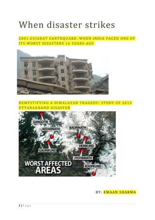
  • 18. 18 | P a g e C A S E S T U D Y : U T T A R A K H A N D FL A S H F L O O D S - J U N E 2 0 1 3 I N T R O D U C T I O N The State of Uttarakhand, being part of the Himalayan region, is extremely vulnerable to natural disasters. Natural hazards, like earthquakes, landslides, avalanches, cloudbursts, hailstorms, Glacial Lake Outburst Floods (GLOFs), flash floods, lightning, and forest fires, etc. have been a cause of major disasters in the State. On 16 June 2013, the State suffered yet another mega disaster, one of the worst disasters in the living memory, causing widespread damage and destruction, besides heavy casualties. The entire State was hit by very heavy rainfall and flash floods. Though all the thirteen districts of the State were hit, five districts, namely Bageshwar, Chamoli, Pithoragarh, Rudraprayag and Uttarkashi were the worst affected. The disaster coincided with the peak tourist and pilgrimage season, significantly enhancing the number of the casualties and adversely affecting the rescue and relief operations. The impact of disaster was most pronounced in the Mandakini valley of the Rudraprayag district. Torrential rains, coupled with the probable collapse of the Chorabari Lake, led to flooding at the Kedarnath Shrine and the adjacent areas of Rambara, Agastyamuni, Tilwara, and Guptkashi. Other pilgrimage centers in the region, including Gangotri, Yamunotri and Badrinath, which are visited by thousands of devotees during the summer season, were also affected. People in important locations, such as the Harsil, Roopkund and Hemkund Sahib, were stranded for days together. Over one lakh people were stuck in various regions of the State due to damaged roads, landslides and flash flood-induced debris. C A U S E S O F T H E D I S A S T E R The disaster essentially occurred due to wide spread heavy rains during the period 14-18 June, which resulted in flash floods in all the major river vallies in the State. Heavy rains triggered major landslide at numerous locations causing severe disruption in surface communications.Extreme rainfall is not an uncommon phenomenon in the region. The historical record suggests that extreme precipitation in one or the other districts of Uttarakhand is quite frequent. The heavy rainfall in the region was the result of convergence of the southwest monsoon trough and westerly disturbances, which led to the formation of dense clouds over the Uttarakhand Himalaya. As per the Indian Meteorological Department (IMD), the rainfall in the State between 15 June and 18 June 2013 was measured at 385.1 mm, against the normal rainfall of 71.3 mm, which was in excess by 440%. Thus, it can be inferred that the disaster was the result of extra precipitation in a very short duration of time, which resulted in heavy water discharge in various rivers and streams. The worst impact of the disaster on human settlements was in the Kedarnath shrine area (Gaurikund to Kedarnath), the Mandakini valley, the Alaknanda valley (at Gobindghat and upstream), the Pindar valley, and along the banks of the river Kali in Dharchula area. The Kedarnath area in particular was impacted the most as it suffered unprecedented devastation with very heavy loss of life and property. Kedarnath Dham Township is located at an altitude of 3583m on the banks of the river Mandakini, which originates from the Chaurabari glacier - about 4 kilometres upstream. It is connected by a motor able road from Rudraprayag up to Gaurikund (40 kms) and thereafter through a mule track,
  • 19. 19 | P a g e running along the Mandakini river. The river Mandakini joins river Alaknanda at Rudraprayag. The likely causes for the disaster in the area of Kedarnath have been a subject of several assessments. As per the Geological Survey of India (GSI), heavy rainfall, which was about 375 per cent more than the benchmark rainfall during normal monsoon, caused the melting of Chorabari Glacier at the height of 3800 metres. This resulted into eruption of the Mandakini River causing heavy floods in the Rudraprayag district and adjacent areas. It was also observed that the heavy rains between 15 and 17 June resulted in exceptionally high rise in the river discharges. The rise in the river level was of the order of 5 - 7m, where the valley was wide and 10 – 12m where the valley was narrow. In the upper stretches of the Mandakini River the stream gradient is high and valley profile is mostly narrow. The gush of water running down from Kedarnath and Rambara areas brought mammoth sediment load which consisted of huge rock boulders with diameter ranging from 3 - 10m. The heavy sediment load along with big boulders acted as a tool of destruction and obliterated everything that came in its way. The enormous volume of water also induced toe erosion along all the river valleys, which in turn, triggered landslides at a number of places. Torrential rains on 15 and 16 June flooded the Saraswati River and Dudh Ganga catchment area, resulting in excessive flow across all the channels. The voluminous water studded with debris from the surrounding regions and glacial moraines struck the Kedarnath town in the evening on 16 June, washing off upper part of the city and leading to the biggest ever devastation seen in the region. Due to heavy downpour, the town of Rambara was also completely washed away in the evening on 16 June. On 17 June 2013 at 6:45 AM, after overflow and collapse of the Chorabari Lake which released large volume of water that caused another flash flood in the Kedarnath town leading to further devastation downstream (Gaurikund, Sonprayag, Phata, etc.). The moraine dammed lake collapsed essentially due to torrential rains resulting in accumulation of millions of gallons of water in the lake within a short span of three days. The prolonged torrential rainfall was probably the main cause of the disaster in Uttarakhand. The loss of human life in the districts of Uttarakashi, Bageshwar, Chamoli and Pithoragarh was relatively less as compared to the Kedarnath valley. I M P A C T O F T H E D I S A S T E R The disaster caused heavy loss of precious lives and extensive damage to private properties and public infrastructure. More than nine million people were affected by the flash floods. The five districts namely, Bageshwar, Chamoli, Pithoragarh, Rudraprayag and Uttarkashi were the worst affected. As far as casualty to human lives is concerned, as informed by the State Government on 09 May 2014, a total of 169 people died and over 4,021 people were reported missing. The suddenness of the flash floods coupled with the high velocity of flow laden with heavy sediment, including boulders washed away pilgrims and locals. The difficult terrain and blockage of roads made it difficult to provide necessary relief to the survivors stranded at isolated locations. The harsh weather conditions i.e. continuous rainfall, chilling cold and non-availability of proper shelter/clothes contributed to the misery endured by the survivors of the disaster. As per report made available by the State Government, a total of 4,200 villages were affected, 11,091 livestock were lost and 2,513 houses were fully damaged. More than 70,000 tourists and 1,00,000 local inhabitants were stranded in the difficult mountain terrain of the upper reaches of the Himalaya.
  • 20. 20 | P a g e E M E R G E N C Y R E S C U E A N D R E L I E F O P E R A T I O N S The Army, Air Force, Navy, Indo-Tibetan Border Police (ITBP), Border Security Force, National Disaster Response Force (NDRF), Public Works Department and local administrations worked together for quick rescue operations. Several thousand soldiers were deployed for the rescue missions. Various Central and State level government and non-government agencies played a significant role in making this operation successful, despite difficult terrain, adverse weather conditions, disrupted roads and lack of telecom connectivity. Several ministries/agencies of the Central Government, departments/agencies of the State Government, governments of other states, NGOs, and corporate sectors, all helped in the evacuation/relief operations. The efforts of the Indian Air Force, the Aviation Corps of the Indian Army and the civil helicopters engaged by the Civil Aviation Department of the State Government played a stellar role in the rescue operations. ITBP distributed food packets to stranded pilgrims who were in a pathetic condition being not having any food for more than 72 hours at many places. All the essential supplies like food, drinking water, medicines, kerosene oil, solar lamps, etc. were continuously provided by air dropping as well as by surface means. A total of 69 relief camps were run, where 1, 51,629 pilgrims/ local residents were looked after. Some camps continued operating beyond the emergency phase for the local residents. Approximately 900 trucks of relief material were received from other states and dispatched to the affected districts from a nodal/ relief centre, set up at Dehradun. Forty-three medical teams comprising of 313 doctors and 4977 para-medical staff, were deployed and essential medicines, bleaching powder and chlorine were regularly supplied. The Health Department of the State coordinated the effort to prevent outbreak of any epidemic. As a result, there was no incidence of outbreak of any epidemic or infectious disease in the State, in spite of the mass cremation of dead bodies and disposal of animal carcasses, or breakdown of potable water supply in some areas. To restore the communication, 105 satellite phones were distributed by the Government of India to various Central and state agencies. Besides, the efforts of BSNL towards restoration of communication were closely monitored by the National Crisis Management Committee. R E S C U E A N D R E L I E F O P E R A T I O N S – O V E R V I E W  NDRF deployed 14 teams for the operation and rescued more than 9,044 persons.  ITBP had deployed about 1,600 personnel for the operation and rescued more than 33,000 persons.  IAF had deployed about 45 helicopters for the operation and rescued more than 23,500 persons.  Indian Army had deployed 8,000 personnel including 150 Special Forces Troops and rescued more than 38,500 persons. 12 army helicopters were also deployed.  Twenty civil aircrafts were utilized by the State Government in the operations which evacuated approximately 12,000 persons.  Nehru Institute of Mountaineering, Uttarkashi, formed five rescue teams of 20 instructors and local youth, and evacuated more than 6,500 stranded persons.  More than 1, 35,000 persons were evacuated from the affected areas in the shortest possible time, notwithstanding widespread destruction of roads, difficult terrain and extremely hostile weather.
  • 21. 21 | P a g e On June 25, an IAF helicopter (Russian-built Mi-17V5) crashed near Gaurikund due to bad weather, while dropping loads in the area. The chopper went down North of Gaurikund, at around 12.30 PM. All the 20 rescuers (05 from IAF, 06 from ITBP and 09 from NDRF), perished in the mishap. On the same day, a team of “GARUD” (The Indian Air Force Commandos) was deployed in the area which recovered the mortal remains of the personnel killed in the accident. A F T E R M A T H The Prime Minister of India undertook an aerial survey of the affected areas and announced₹10 billion aid packages for disaster relief efforts in the state. The Government of India also cancelled 9 batches, or half the annual batches of the Kailash- Mansarovar Yatra, a Hindu pilgrimage. The Chardham Yatra pilgrimage, covering Gangotri, Yamunotri, Kedarnath and Badrinath was cancelled for 2 years to repair damaged roads and infrastructure, according to the Uttarakhand Government.