Call Girls Ramtek Call Me 7737669865 Budget Friendly No Advance Booking
EOPS_2019_07_29.pdf
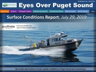
1. Up-to-date observations of water quality conditions in Puget Sound and coastal bays.
Surface Conditions Report: July 29, 2019
Eyes Over Puget Sound
Publication No. 19-03-074
Summary Stories Diving & critters Climate & streams Combined factors Marine water Aerial photos Info
Anchovies provide new
opportunities in South Sound
2. Guest contribution p.3
Anchovies provide new opportunities in South Sound.
Personal stories p. 8
Macroalgae growth is fueled by excessive nutrients and
sunshine. When it washes onto the beach, it is called beach
wrack, and it can turn into a health risk to beachgoers.
Climate & streams p. 10
In July, some recent trends of warm, dry conditions
weaken, but river flows remain low.
Water temperature and food web p. 14
In June, average surface water temperatures were slightly
warmer with good temperatures for geoduck growth.
South Sound exceeded water temperatures needed for
herring to spawn. Inching now toward optimum anchovy
spawning temperatures.
Aerial photography p. 15
There were large numbers of fish in South Sound and
southern Hood Canal, and lots of macroalgae on the water
in South and Central Sound. Hood Canal was bright
turquoise, stained from a bloom of coccolithophore.
LONG-TERM
MARINE
MONITORING
UNIT
Editorial assistance provided by: Julianne Ruffner, Suzan Pool, Ruth Froese.
Summary conditions at a glance
Summary Stories Diving & critters Climate & streams Combined factors Marine water Aerial photos Info
Skip Albertson
Dr. Christopher
Krembs (Editor)
Tyler Burks
Jim Shedd
Julianne Ruffner
Laura Hermanson
Phillip Dionne
Steve Jeffries
Todd Sandell
3. DFW staff are documenting anchovies in high numbers in winter 2019, and numbers remain high in July.
Location: A., B. Budd Inlet, C. Peale Passage, D. Eld Inlet (South Sound)
A. B.
C. D.
1:57 PM
DFW staff in winter 2019
1:54 PM
3:16 PM
fish
fish
fish
boat
Large schools of anchovy in Budd Inlet, Eld Inlet, and Peale Passage
Anchovies provide new opportunities in South Sound
Summary Stories Diving & critters Climate & streams Combined factors Marine water Aerial photos Info
How do we know it’s fish?
fish
fish
fish
fish fish
jellyfish
fish
fish
fish
fish
boat
4. DFW staff are documenting anchovies in high numbers in winter 2019, and numbers remain high in July.
Location: A. and B. Totten Inlet (South Sound) How do we know it’s fish?
Todd Sandell, DFW
Steve Jeffries, DFW
Phillip Dionne, DFW
A.
B.
Large schools of anchovy in Totten Inlet
Summary Stories Diving & critters Climate & streams Combined factors Marine water Aerial photos Info
Anchovies provide new opportunities in South Sound
pens
fish
fish
fish
fish
fish
fish
fish
fish
5. In July, fish schools in Totten Inlet (A) outnumbered
those in Case Inlet (B), where fish schools occurred
in high numbers in May and supported a huge
group of California sea lions (C) and other mammals
during late winter 2019.
A. B.
C.
Large schools of anchovy in Totten Inlet
Summary Stories Diving & critters Climate & streams Combined factors Marine water Aerial photos Info
Anchovies provide new opportunities in South Sound
fish
fish
fish
fish
fish
fish
fish
fish
fish
fish
fish
fish
fish
fish
fish
fish
fish
6. Large schools of fish are also present in Hood Canal
Summary Stories Diving & critters Climate & streams Combined factors Marine water Aerial photos Info
Anchovies provide new opportunities in Hood Canal
Many small fish schools and a coccolithophore bloom in Southern Hood Canal.
Location: 3 miles west of Sun Beach (Hood Canal), 2:08 PM
fish
boat
fish
fish
fish
fish
7. B.
B.
A. Google images help us figure it out.
Fish move around—seagrass beds do not.
A. Round dark patches in photos taken on 7-29-2019 in Totten Inlet are
not present in Google images (date unknown) and therefore very likely
schooling fish.
How can we tell what might be schooling fish vs. seagrass?
Summary Stories Diving & critters Climate & streams Combined factors Marine water Aerial photos Info
Google image
schooling
fish
B. The dark patches are missing in Google images yet other nearshore features are preserved.
?
Anchovies provide new opportunities in Hood Canal
8. Advisories are
issued if we
see high levels
of bacteria in
the water.
Washed up wrack
on the beach can
harbor bacteria.
Macroalgae washed ashore at Dash Point State Park
Beach wrack can be a health risk to beachgoers.
Julianne Ruffner & Laura Hermanson
Signs warn of exposure risk
Personal Field Impression
Summary Stories Diving & critters Climate & streams Combined factors Marine water Aerial photos Info
Washington BEACH Program – Eyes on the Beach
Read swimming tips to minimize your risk of illness while visiting our beaches.
“
Large piles of organic debris can wash up on beaches. This wrack lingers on
beaches and in shallow waters and can act as a reservoir for bacteria. If you
come in contact with bacteria in wrack, sand, or water, your risk of getting sick
increases. To prevent you and your family from getting exposed, the BEACH
program monitors fecal indicator bacteria and advises beachgoers when
bacteria numbers are high. At normal levels, beach wrack provides food and
shelter for many invertebrates and should not be removed. Read more
9. Critter of the Month – The Striped Nudibranch
Dany Burgess & Angela Eagleston,
Marine Sediment Monitoring Team
Fun Striped Nudibranch Facts
• They hide beneath the sand
during the day, emerging at night
to hunt.
• Sensory organs on their heads,
called rhinophores, help them
“smell” the location of their sea
pen prey.
• They incorporate toxins from sea
pens into their tissues, making
them distasteful to other
animals.
Armina californica
July’s critter may look cute
and innocent, but beneath the
squishy sea slug body and
beautiful stripes lies a
ferocious predator. Meet the
striped nudibranch: a
taxonomist’s dream and a sea
pen’s nightmare!
Image by Dave Cowles, wallawalla.edu
Learn more about the striped nudibranch and other critters on Ecology’s EcoConnect blog.
Eyes Under Puget Sound - Critter of the month
Summary Stories Diving & critters Climate & streams Combined factors Marine water Aerial photos Info
10. Best and worst horizontal visibility
at corresponding vertical depth
This is a new feature and we are soliciting feedback
(skip.albertson@ecy.wa.gov).
Good Poor
Visibility
What was the water visibility like for divers?
Location
Best Visibility Worst Visibility
Horizontal
Distance
(ft.)
Vertical
Depth
(ft.)
Horizontal
Distance
(ft.)
Vertical
Depth
(ft.)
1 22 97 5 11
2 11 23 6 3
3 17 2 14 98
4 26 77 7 7
5 18 41 15 3
6 32 98 9 3
7 30 54 13 3
8 40 79 14 3
9 46 61 12 3
10 25 7 7 46
11 61 79 5 10
12 32 98 8 11
13 23 41 2 16
14 49 61 14 5
15 5 5 5 33
16 44 67 29 7
17 44 97 15 10
18 11 28 1 8
(only best visibility shown)
Best visibility in July Find depths with high/low
visibility
• Best visibility occurred in Hood
Canal near Octopus Hole
(location 11) with 61 ft visibility
(at 79 ft depth), despite having
poor visibility near the surface.
• Poor visibility (no diver icon)
occurred in Oakland Bay near
Shelton (location 18) with 1 ft
visibility at a depth of 8 ft.
• The poster, “Underwater Visibility
Maps – a Tool for Scuba Divers,”
is available here.
Personal Field Impression
Summary Stories Diving & critters Climate & streams Combined factors Marine water Aerial photos Info
What can you find underwater?
11. During the last 30 days, Puget Sound air temperatures and precipitation were generally dependent
on elevation (A). It was cooler at high elevations with some precipitation, and drier and warm in the
lowlands. During the next 30 days, temperatures are expected to be moderately warmer than
normal, and precipitation is expected to be normal with some deficits in the Cascades (B).
How much water did we get and what can we expect?
Summary Stories Diving & critters Climate & streams Combined factors Marine water Aerial photos Info
A. Northwest Climate Toolbox (Previous 30 days) B. Northwest Climate Toolbox (Next 30 days)
Temperature Anomaly
from historical mean ranged
from -4 to +3 °F in the Puget
Sound region during the
past 30 days.
Precipitation Anomaly
from historical mean
ranged from -2 to +3 inches
in the Puget Sound region
during the past 30 days.
Temperature Precipitation Temperature Precipitation
Precipitation Anomaly
from historical mean is
forecasted to be up 0 to -1
inches in the Puget Sound
region during the next 30
days.
Temperature Anomaly
from historical mean is
forecasted to be +2 °F in the
Puget Sound region during
the next 30 days.
12. Moderate temperatures and variable precipitation conditions have resulted in below-normal freshwater inputs
to Puget Sound (trend charts, left). Current flow distribution across the watershed is mixed (map, right), due to
variable rates of decline after recent precipitation in mid-July. Precipitation has slowed steep declines after
early snowmelt, but may not sustain flows for the remainder of the summer.
How much water flows into Puget Sound?
Summary Stories Diving & critters Climate & streams Combined factors Marine water Aerial photos Info
Daily
average
discharge,
in
cubic
feet
per
second
Select Puget Sound Streamflow Trends
Daily
average
discharge,
in
cubic
feet
per
second
Current Streamflow Conditions as of 7/30/2019
Current conditions: CLICK HERE!
USGS WaterWatch: CLICK HERE!
Skagit River near Mt. Vernon
(12200500)
Snohomish River near Monroe
(12150800)
Puyallup River at Puyallup
(12101500)
13. Climateinfluences:HowwellisPugetSoundexchangingits water?
The Fraser River is the major driver of
estuarine circulation and water
exchange between the Salish Sea and
the ocean. Fraser River flows are below
expected levels. Dramatic snow melt
in May resulted in well below normal
flows.
Historically, the peaks of coastal upwelling and the freshet are in sync. In 2019, the freshet is weak.
NPGO
(x10)
PDO/Upwelling
Index
How do ocean boundary conditions
affect the quality of water we
exchange with the ocean?
Recent years’ warm water is gone
(PDO) and upwelling is expected
(Upwelling Index anomaly). NPGO,
which reflects the surface productivity
along the coast, is expected as well.
Pacific Decadal Oscillation Index (PDO, temperature, explanation). Upwelling Index (anomalies) (Upwelling, low
oxygen, explanation). North Pacific Gyre Oscillation Index (NPGO, productivity, explanation).
Three-year running average of PDO, Upwelling, and NPGO Indices
Summary Stories Diving & critters Climate & streams Combined factors Marine water Aerial photos Info
Fraser River (at midnight)
Higher than normal
Lower than normal
Expected
-25
-15
-5
5
15
25
-2
-1
0
1
2
1945 1950 1955 1960 1965 1970 1975 1980 1985 1990 1995 2000 2005 2010 2015
14. What influences Puget Sound’s water quality?
higher No data
lower
expected
*Upwelling/downwelling Anomalies (PFEL)
PDO = Pacific Decadal Oscillation
ENSO = El Niño Southern Oscillation
In the anomaly plot, we want to connect different factors influencing water quality in the
context of space and time. Conditions leading up to June 2019 were drier with lower river
flows than in Spring 2018. The past winter was consistently warmer than the previous two
winters, although February was much colder. Early onset upwelling was a factor in both 2018
and 2019. For recent river and stream inflow, see page 12.
Summary Stories Diving & critters Climate & streams Combined factors Marine water Aerial photos Info
All data are from public sources: UW GRAYSKIES; river
flows from USGS and Environment Canada; indices from
NOAA & UW (PDO).
Conditions leading up to August:
Air temperatures were again generally
warmer this year, except in February
and early March.
Precipitation for the past five months
was lower than in 2018, but July was
wet and provided a break.
Sunshine (opposite of cloud cover) has
been generally high, except in July.
River flows into Puget Sound have
been generally low since June 2018.
Upwelling started earlier in spring both
in 2018 and 2019. ENSO has showed
warming.
15. Summary Stories Diving & critters Climate & streams Combined factors Marine water Aerial photos Info
Water temperature affects ecosystem performance
Warmer than expected
Cooler than expected
Expected 18-year average
Legend:
Can organisms
thrive and survive?
The life cycles of organisms
respond to temperature. To
be successful, the timing of
early life stages must line up
with good growth conditions.
Temperature is important for
growth, but also dictates if
certain organisms can
overwinter in Puget Sound
(e.g., Northern anchovy).
* Help us get these right. We scoured the
literature for temperatures important to
the success and survival of marine
organisms.
Lifecycles
Temperature
Climate
In June, average surface water temperatures (0 – 30 m deep) were slightly
warmer than the baseline (1999 – 2016). Optimal temperatures for geoduck
growth were reached inside Puget Sound and Hood Canal. South Sound
surpassed water temperatures for herring to spawn but is inching toward
optimum anchovy spawning temperatures.
Optimal temperatures for
Puget Sound organisms*
16. What are the conditions at the surface?
Start here
Bloom
Debris
Front
Plume
Narrow Hammersley Inlet connecting Oakland Bay
Mixing and fronts:
Tidal eddies near Blake Island, Liberty Bay, and Dyes Inlet.
Several fronts in Nisqually Reach.
Debris:
Orange-colored organic material of Noctiluca in Central Sound,
Dyes Inlet, and Case Inlet. Extensive rafts of macroalgae in
Central and South Sound.
Visible blooms:
Brown-green blooms in Central Sound and Sinclair Inlet.
Red-brown bloom in Totten Inlet, Henderson Inlet, Budd Inlet,
and Keyport Bay.
Turquoise bloom in Southern Hood Canal.
Green bloom in Oro Bay.
Jellyfish and fish:
Jellyfish patches in Quartermaster Harbor. Schools of fish in
Totten, Eld, Budd, Case Inlets, Peale Passage and southern
Hood Canal.
Suspended sediment:
Glacial flour from the Puyallup River flowing into the Tacoma
Narrows.
Macroalgae on the water are very abundant in South and Central Sound. Noctiluca are still active in
Central Sound and Case Inlet. A large coccolithophore bloom is present in Southern Hood Canal.
Totten and other finger inlets in South Sound and Southern Hood Canal enjoy a huge number of fish.
Jellyfish are abundant in Quartermaster Harbor.
Summary Stories Diving & critters Climate & streams Combined factors Marine water Aerial photos Info
Macroalgae in Capitol Lake, Olympia 7/29/2019
Red-brown bloom Keyport Lagoon, 6/26/2019
Bloom
17. Flight
Strait of
Juan de Fuca
San Juan Islands
Main Basin
Hood Canal
Whidbey Basin
Sunny and hazy
Flight Observations
Aerial navigation guide
South Sound
Summary Stories Diving & critters Climate & streams Combined factors Marine water Aerial photos Info
Padilla Bay
Tide data from 7/29/2019 (Seattle):
Time Pred High/Low
2:07 AM 10.6 H
9:22 AM -1.48 L
5:07 PM 10.62 H
10:03 PM 7.49 L
11
12
13
14
16
17
18
6
10
15
1
3
2
4
7
8
9
5
People sharing images
20
19
3 8 13
18. Red-brown bloom, schooling fish, and a patch of jellyfish.
Location: Eld Inlet (South Sound), 1:49 PM
1 Aerial photography 7-29-2019 Navigate
Summary Stories Diving & critters Climate & streams Combined factors Marine water Aerial photos Info
Flapjack Point
Green Cove
fish
jellyfish
Bloom
boat
19. Schools of fish and bloom contrasted by incoming clear tidal water via Squaxin Passage.
Location: Hope Island (South Sound), 1:56 PM
2 Navigate
Summary Stories Diving & critters Climate & streams Combined factors Marine water Aerial photos Info
Aerial photography 7-29-2019
Potlatch Point
Hope Island
Arcadia Point
fish
fish
fish
fish
Bloom
Debris
Front
boat
20. A. Schools of fish, red-brown bloom at the entrance to Pickering Passage. B. Noctiluca bloom on July 23.
Location: Pickering Passage, Case Inlet (South Sound), 2:02 PM
Stretch Island
McLane Cove
A. B.
3 Navigate
Summary Stories Diving & critters Climate & streams Combined factors Marine water Aerial photos Info
Aerial photography 7-29-2019
7/23/2019
Bloom
Debris
boat
cabin reflections
Citizen contribution
Bloom
fish
seagrass seagrass
21. Strong coccolithophore bloom stretching from Union (A) to Lynch Cove (B). C. Twanoh State Park.
Location: A–D. Southern Hood Canal (Hood Canal)
A. B.
C.
D.
2:13 PM
2:13 PM
2:14 PM
E.
4 Navigate
Summary Stories Diving & critters Climate & streams Combined factors Marine water Aerial photos Info
Aerial photography 7-29-2019
D. NASA satellite image southern Hood Canal E. Microscopic coccolithophore
Twanoh
Forest Beach
Ayres Point
Ayres Point
7/13/2019
Bloom
Bloom
Bloom
boat
boat
boat
22. Noctiluca and tidal eddies bringing in algal bloom from Sinclair Inlet and mixing into water of Dyes Inlet.
Location: Dyes Inlet (Central Sound), 2:30 PM
5 Navigate
Summary Stories Diving & critters Climate & streams Combined factors Marine water Aerial photos Info
Aerial photography 7-29-2019
Rocky Point
Bloom
Debris
Debris
boat
boat
23. Large tidal eddy with bloom in Liberty Bay.
Location: Liberty Bay (Central Sound), 2:34 PM
6 Navigate
Summary Stories Diving & critters Climate & streams Combined factors Marine water Aerial photos Info
Aerial photography 7-29-2019
Bloom
boat
boat
eddy
24. 7 Navigate
Summary Stories Diving & critters Climate & streams Combined factors Marine water Aerial photos Info
Aerial photography 7-29-2019
Large rafts of macroalgae stretching along Suquamish shoreline into the bay.
Location: Port Madison (Central Sound), 2:36 PM
Suquamish
Agate Point
Debris
boat
boat
boat
macroalgae
25. A. & B. Large rafts of macroalgae. C. Macroalgae washing onto beaches. D. Beachgoers touching macroalgae.
Location: A. Across Discovery Park, B. Blakely Harbor, C. Burien, D. Dash Point (Central Sound), 2:39 PM
Discovery Park
A. B.
C.
D.
8 Navigate
Summary Stories Diving & critters Climate & streams Combined factors Marine water Aerial photos Info
Aerial photography 7-29-2019
Citizen contribution
Citizen contribution
Debris
macroalgae
boat
26. A.
B.
9 Navigate
Summary Stories Diving & critters Climate & streams Combined factors Marine water Aerial photos Info
Aerial photography 7-29-2019
Discovery Park
Debris
macroalgae
A. Large rafts of macroalgae. B. Macroalgae stretching across Central Basin to Murdon Cove.
Location: A. Across Discovery Park, Seattle, B. Murden Cove, Bainbridge Island (Central Sound), 2:40 PM
boat
27. Large rafts of macroalgae stretching along the shores of Manchester.
Location: Manchester (Central Sound), 2:41 PM
10 Navigate
Summary Stories Diving & critters Climate & streams Combined factors Marine water Aerial photos Info
Aerial photography 7-29-2019
Ford Ward
Manchester
Debris
macroalgae
boat
28. Blake Island
A.
B.
11 Navigate
Summary Stories Diving & critters Climate & streams Combined factors Marine water Aerial photos Info
Aerial photography 7-29-2019
Water lined with macroalgae and stained by bloom circulating in large eddy.
Location: Blake Island A. looking North B. looking East (Central Sound), 2:46 PM
Bloom
Debris
macroalgae
boat
ship
29. Multiple large rafts of macroalgae stretching along the shores of Vashon Island.
Location: Vashon Island (Central Sound), 2:48 PM
12 Navigate
Summary Stories Diving & critters Climate & streams Combined factors Marine water Aerial photos Info
Aerial photography 7-29-2019
Vashon Island
Bloom
Debris
macroalgae
30. A. Large aggregations of moon jellies in several locations of the inner bay. B. Citizen contribution.
Location: Quartermaster Harbor (Central Sound), 2:53 PM
Portage
boat
A. B.
13 Navigate
Summary Stories Diving & critters Climate & streams Combined factors Marine water Aerial photos Info
Aerial photography 7-29-2019
Citizen contribution
jellyfish
Citizen contribution
31. Puyallup River plume lined by macroalgae flowing into the Tacoma Narrows during incoming tide.
Location: Vashon Island (Central Sound), 2:57 PM
14 Navigate
Summary Stories Diving & critters Climate & streams Combined factors Marine water Aerial photos Info
Aerial photography 7-29-2019
Point Defiance
Vashon Island
Plume
Debris
macroalgae
ship
32. Puyallup River plume flowing into the Tacoma Narrows during incoming tide.
Location: Vashon Island (Central Sound), 2:57 PM
15 Navigate
Summary Stories Diving & critters Climate & streams Combined factors Marine water Aerial photos Info
Aerial photography 7-29-2019
Point Defiance
Vashon Island
Plume
ferry
33. Nisqually River delta and Mount Rainier. A place worth protecting for generations to come.
Location: Nisqually Reach (South Sound), 3:10 PM
16 Navigate
Summary Stories Diving & critters Climate & streams Combined factors Marine water Aerial photos Info
Aerial photography 7-29-2019
34. Bloom in Oro Bay.
Location: Anderson Island (South Sound), 3:09 PM
17 Navigate
Summary Stories Diving & critters Climate & streams Combined factors Marine water Aerial photos Info
Aerial photography 7-29-2019
Oro Bay
Ketron Island
Bloom
Bloom
Bloom
boat
35. Macroalgae accumulating along tidal front.
Location: Nisqually Reach (South Sound), 3:10 PM
18 Navigate
Summary Stories Diving & critters Climate & streams Combined factors Marine water Aerial photos Info
Aerial photography 7-29-2019
Bloom
Bloom
macroalgae
Anderson
Island
boat
36. Red-brown bloom and green bloom.
Location: Henderson Inlet (South Sound), 3:14 PM
19 Navigate
Summary Stories Diving & critters Climate & streams Combined factors Marine water Aerial photos Info
Aerial photography 7-29-2019
Gahm Peninsula
boat
Bloom
Bloom
Bloom
37. Noctiluca in various places documented by engaged citizens.
Location: A. Vashon Island, B. Commencement Bay, C. Smith Cove, Elliot Bay (Central Sound).
Maury Island
A. B. C.
6/25/2019
7/29/2019 6/24/2019
20 Navigate
Summary Stories Diving & critters Climate & streams Combined factors Marine water Aerial photos Info
Aerial photography 7-29-2019
Citizen contribution
Citizen contribution
Debris
boat
38. Find past editions of EOPS on the next pages
Summary Stories Diving & critters Climate & streams Combined factors Marine water Aerial photos Info
We have published 82 editions!
Recommended Citation (example for September 2018 edition):
Washington State Department of Ecology. 2018. Eyes Over Puget Sound: Surface Conditions
Report, September 17, 2018. Publication No. 18-03-075. Olympia, WA.
https://fortress.wa.gov/ecy/publications/documents/1803075.pdf.
Find all previous Eyes Over Puget Sound editions at the end of this document.
Contact:
Dr. Christopher Krembs
Christopher.Krembs@ecy.wa.gov
Marine Monitoring Unit
Environmental Assessment Program
Washington State
Department of Ecology
Subscribe to the Eyes Over
Puget Sound email listserv.
Many thanks to our business partners:
Shannon Point Marine Lab (WWU), Jorgensen Air