Natural Disasters Topic 4 (Earthquakes)
•Transferir como PPTX, PDF•
6 gostaram•3,720 visualizações

Earthquake basics for a GE-level course in natural disasters.

Recomendados
Mais conteúdo relacionado
Mais procurados
Mais procurados (20)
Destaque
Destaque (20)
Semelhante a Natural Disasters Topic 4 (Earthquakes)
Semelhante a Natural Disasters Topic 4 (Earthquakes) (20)
Mais de William W. Little
Mais de William W. Little (20)
Último
Último (20)
Natural Disasters Topic 4 (Earthquakes)
- 1. Earthquakes
- 2. What is an Earthquake?
- 4. Stress vs. Time Stress
- 8. Types of Seismic Waves Body Waves Surface Waves
- 9. Primary (P) Waves •Longitudinal (forward) motion •Move by compression & expansion •Fastest of the wave types •Travel through solids & liquids
- 10. Secondary (S) Waves •Shear (sideways) motion •Move by lateral displacement •Second fastest of the wave types •Travel through solids only
- 11. Love (L) Waves •Shear (sideways) motion •Move by lateral displacement •Second slowest of the wave types •Travel through solids only
- 12. Rayleigh (R) Waves •Elliptical motion •Move by rotational displacement •Slowest of the wave types •Travel through solids and liquids
- 14. Where Do Earthquakes Occur?
- 16. Plate Boundaries From Tarbuck and Lutgens Divergent Transform Convergent
- 18. Benioff Zones
- 19. Types of Movement Divergent Plate Boundary Convergent Plate Boundary Transform Plate Boundary
- 20. Faults Faults are fractures along which there has been vertical and/or horizontal movement.
- 21. Normal Reverse Types of Faults Strike-slip Faults are classified by the relative direction of movement of the rocks on either side with respect to each other side.
- 22. Normal Faults Normal faults form as a result of tension. The hanging wall moves downward with respect to the footwall. They are referred to as normal because they appear to have “slipped” in response to gravitational forces.
- 30. Mountain and Valley Topography A characteristic of normal faulting in highly extensional terrains, such as continental divergent plate boundaries, is that of alternating mountain ranges (horsts) and valleys (grabens).
- 33. Reverse Faults Reverse faults form as a result of compression. The hanging wall moves upward with respect to the footwall. They are referred to as reverse because they demonstrate the opposite motion of normal faults.
- 35. Thrust Faults Thrust faults are reverse faults with a low dip angle. They are often associated with folding and are typically found in association with convergent plate boundaries.
- 37. Strike-slip Faults Strike-slip faults form as a result of lateral shearing. The two sides of the fault move laterally past one another.
- 40. Methods of Measurement Richter Scale Mercalli Scale Charles Richter Giuseppe Mercalli •Measures energy released •Determined by wave amplitude •Measures “intensity” •Determined by degree of damage We now use the “moment magnitude Now referred to as the modified Mercalli Scale
- 43. QuickTime™ and a Photo - JPEG decompressor are needed to see this picture.
- 46. Qui ckTi me™ and a Photo - JPEG decompressor are needed to see this picture. The largest recorded earthquakes: Chile, 1960 – 8.3 on the Richter Scale, Mw= 9.5 Alaska, 1964 – 8.4 on the Richter Scale, Mw= 9.2 For each unit-increase in magnitude: Ground Shaking increases by a power of 10 (10x) Energy released increases by a power of 30 (30x)
- 47. Largest Earthquakes in the World Since 1900 Location Date UTC Magnitude Coordinates 1. Chile 1960 05 22 9.5 38.24 S 73.05 W 2. Prince William Sound, Alaska 1964 03 28 9.2 61.02 N 147.65 W 3. Andreanof Islands, Alaska 1957 03 09 9.1 51.56 N 175.39 W 4. Kamchatka 1952 11 04 9.0 52.76 N 160.06 E 5. Off the West Coast of Northern Sumatra 2004 12 26 9.0* 3.30 N 95.78 E 6. Off the Coast of Ecuador 1906 01 31 8.8 1.0 N 81.5 W 7. Rat Islands, Alaska 1965 02 04 8.7 51.21 N 178.50 E 8. Assam - Tibet 1950 08 15 8.6 28.5 N 96.5 E 9. Kamchatka 1923 02 03 8.5 54.0 N 161.0 E 10. Banda Sea, Indonesia 1938 02 01 8.5 5.05 S 131.62 E 11. Kuril Islands 1963 10 13 8.5 44.9 N 149.6 E *now 9.3
- 48. Table 4-1, p. 87 (possibly 750,000)
- 53. Qui c kTi me™ and a Photo - JPEG decompressor are needed to see this picture.
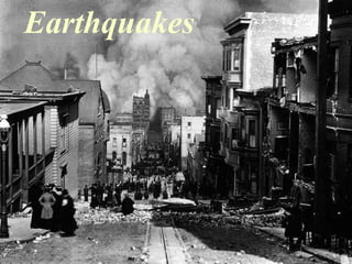
- 55. Earthquake Destruction Intensity map for the 1886 Charleston Earthquake Earthquake destruction takes a variety of forms, depending upon geological setting, strength of the quake, and the nature of construction.
- 59. Ground Rupture
- 60. Qui ckTi me™ and a Photo - JPEG decompressor are needed to see this picture.
- 62. QuickTime™ and a Photo - JPEG decompressor are needed to see this picture.
- 64. Ground Shaking QuickTime™ and a Photo - JPEG decompressor are needed to see this picture.
- 69. Mexico City 1985
- 70. Indirect Damage
- 72. Landslides Q uickT ime™ and a Photo - JPEG decompressor are needed to see this picture.
- 73. Landslides (slumping) Alaska 1964 Alaska 1964
- 74. Tsunamis
- 80. Historical Records Plotting of historical earthquakes (location and size) can be used to predict the degree of likely hazard for a given area.
- 81. Geologic History Trenching and drilling along and across a fault can give us an idea of how often and how frequently it has moved in the past. Video 11:38 – 15:32
- 82. Seismic Gaps
- 83. Stress vs. Time Stress
- 84. M 9.1 Dec. 2004 M 8.8 Feb. 2010 M 7.0 Jan. 2010 M 8.1 Sep. 2009 M 9.0 Mar. 2011
- 85. Fault Asperity
- 86. Characterisic Quakes 1910 AD 200 AD
- 88. Earthquake Frequency USGS PAGERCAT 1900-2008, USGS-NEIC & gCMT 2008-present Plot of number of earthquakes M7.5 and larger since 1900.
- 89. Fore- and Aftershocks Timing and magnitude of earthquakes for Tohoku, Japan.
- 90. Mitigation
- 92. p. 105c
- 93. Fig. 4-40, p. 101 Base Isolators
- 94. p. 105b
- 95. p. 105a
- 96. p. 105d
- 98. Tsunami Detection Video 24:19 – 35:23